[{"name":"Everest Base Camp Helicopter Tour","duration":"1","image_url":"https:\/\/www.havenholidaysnepal.com\/storage\/trip-galleries\/1\/thumb_6cd53005d75a86e373d31419d1b14d78.webp","offer_price":1195,"url":"https:\/\/www.havenholidaysnepal.com\/trips\/everest-base-camp-helicopter-tour"},{"name":"Everest Mountain Flight","duration":"1","image_url":"https:\/\/www.havenholidaysnepal.com\/storage\/trip-galleries\/4\/thumb_3b0b4f1d6f72b0ad224daf4752f2c6e0.jpg","offer_price":285,"url":"https:\/\/www.havenholidaysnepal.com\/trips\/everest-mountain-flight"},{"name":"Everest Short Trek","duration":"9","image_url":"https:\/\/www.havenholidaysnepal.com\/storage\/trip-galleries\/5\/thumb_BXPP3621.JPEG0.02033800 1727957098.webp","offer_price":995,"url":"https:\/\/www.havenholidaysnepal.com\/trips\/everest-short-trek"},{"name":"Gokyo Valley Trek","duration":"12","image_url":"https:\/\/www.havenholidaysnepal.com\/storage\/trip-galleries\/6\/thumb_10bc469b14731f23d3ce84a7092ad53f.jpg","offer_price":1195,"url":"https:\/\/www.havenholidaysnepal.com\/trips\/gokyo-valley-trek"},{"name":"15 days Annapurna Base Camp Trek","duration":"15","image_url":"https:\/\/www.havenholidaysnepal.com\/storage\/trip-galleries\/7\/thumb_87d1533bc45faf070990aef0579e4be4.jpg0.81855100 1728285496.webp","offer_price":785,"url":"https:\/\/www.havenholidaysnepal.com\/trips\/15-days-annapurna-base-camp-trek"},{"name":"Nepal Pilgrimage Tour","duration":"14","image_url":"https:\/\/www.havenholidaysnepal.com\/storage\/trip-galleries\/8\/thumb_02c3bcf2ad2e8a4c1703e90ae747b5f1.jpg","offer_price":1475,"url":"https:\/\/www.havenholidaysnepal.com\/trips\/nepal-pilgrimage-tour"},{"name":"UNESCO World Heritage Site Tour","duration":"10","image_url":"https:\/\/www.havenholidaysnepal.com\/storage\/trip-galleries\/9\/thumb_unesco-world-heritage-site-Lumbani-temple-buddhists-hindus-kathmandu-nepal0.36988600 17347617740.93089500 1737469667.webp","offer_price":715,"url":"https:\/\/www.havenholidaysnepal.com\/trips\/unesco-world-heritage-site-tour"},{"name":"Island Peak Climbing","duration":"16","image_url":"https:\/\/www.havenholidaysnepal.com\/storage\/trip-galleries\/11\/thumb_Island peak0.53947000 1734692503.webp","offer_price":2495,"url":"https:\/\/www.havenholidaysnepal.com\/trips\/island-peak-climbing"},{"name":"Upper Mustang Trek","duration":"18","image_url":"https:\/\/www.havenholidaysnepal.com\/storage\/trip-galleries\/12\/thumb_upper mustang 7 Oct-2024.jpg0.95398900 1728286166.webp","offer_price":2995,"url":"https:\/\/www.havenholidaysnepal.com\/trips\/upper-mustang-trek"},{"name":"Annapurna Circuit Trek","duration":"16","image_url":"https:\/\/www.havenholidaysnepal.com\/storage\/trip-galleries\/15\/thumb_tibetan-flags.jpg0.04843900 1728289138.webp","offer_price":985,"url":"https:\/\/www.havenholidaysnepal.com\/trips\/annapurna-circuit-trek"},{"name":"Gosainkunda Lake Trek","duration":"10","image_url":"https:\/\/www.havenholidaysnepal.com\/storage\/trip-galleries\/16\/thumb_5A8083B3-C007-41A8-853F-D0C37C97D235_1_105_c.jpeg0.52581200 1731845258.webp","offer_price":595,"url":"https:\/\/www.havenholidaysnepal.com\/trips\/gosainkunda-lake-trek"},{"name":"Zip-lining in Pokhara and Dhulikhel","duration":"1","image_url":"https:\/\/www.havenholidaysnepal.com\/storage\/trip-galleries\/18\/thumb_215f765e2ebc995dd5c800b4bfdbacc3.jpg","offer_price":82,"url":"https:\/\/www.havenholidaysnepal.com\/trips\/zip-lining-in-pokhara-and-dhulikhel"},{"name":"Annapurna Heli Tour","duration":"1","image_url":"https:\/\/www.havenholidaysnepal.com\/storage\/trip-galleries\/19\/thumb_d71a6bbb9fd4da8d1b567a5cdbdec85d.jpg","offer_price":555,"url":"https:\/\/www.havenholidaysnepal.com\/trips\/annapurna-heli-tour"},{"name":"Paragliding in Pokhara","duration":"1","image_url":"https:\/\/www.havenholidaysnepal.com\/storage\/trip-galleries\/20\/thumb_de788d2dd9726783431f882c007efae1.jpg","offer_price":65,"url":"https:\/\/www.havenholidaysnepal.com\/trips\/paragliding-in-pokhara"},{"name":"Ultra-Flight in Pokhara","duration":"1","image_url":"https:\/\/www.havenholidaysnepal.com\/storage\/trip-galleries\/21\/thumb_e27a9fb572a5c21611bb2a3c18e4b8f0.jpeg","offer_price":175,"url":"https:\/\/www.havenholidaysnepal.com\/trips\/ultra-flight-in-pokhara"},{"name":"Sarangkot Hiking","duration":"1","image_url":"https:\/\/www.havenholidaysnepal.com\/storage\/trip-galleries\/22\/thumb_100ef822fea19987166c6c1366215f15.jpg","offer_price":55,"url":"https:\/\/www.havenholidaysnepal.com\/trips\/sarangkot-hiking"},{"name":"Mera Peak Climbing","duration":"18","image_url":"https:\/\/www.havenholidaysnepal.com\/storage\/trip-galleries\/24\/thumb_d16ae3895f678cf26ffbf2455f541fb5.jpg0.31883400 1732617790.webp","offer_price":2475,"url":"https:\/\/www.havenholidaysnepal.com\/trips\/mera-peak-climbing"},{"name":"Lower Dolpo Trek","duration":"18","image_url":"https:\/\/www.havenholidaysnepal.com\/storage\/trip-galleries\/26\/thumb_Dolpo Galary - 1.JPG0.37725200 1727939952.webp","offer_price":2995,"url":"https:\/\/www.havenholidaysnepal.com\/trips\/lower-dolpo-trek"},{"name":"Nagarkot Sunrise\/Sunset Tour","duration":"1","image_url":"https:\/\/www.havenholidaysnepal.com\/storage\/trip-galleries\/27\/thumb_5147a5532644283a380f2e86f3857c13.jpg0.17748000 1728488108.webp","offer_price":30,"url":"https:\/\/www.havenholidaysnepal.com\/trips\/nagarkot-sunrise-sunset-tour"},{"name":"16 day Everest Base Camp Trek","duration":"16","image_url":"https:\/\/www.havenholidaysnepal.com\/storage\/trip-galleries\/28\/thumb_IMG_4311.JPG0.64984800 1727942213.webp","offer_price":1475,"url":"https:\/\/www.havenholidaysnepal.com\/trips\/16-day-everest-base-camp-trek"},{"name":"Ghorepani Poon Hill trek with Jungle Safari and Trishuli River Rafting -13 days","duration":"13","image_url":"https:\/\/www.havenholidaysnepal.com\/storage\/trip-galleries\/29\/thumb_Ghorepani Poon hill.jpg0.48460800 1728281439.webp","offer_price":795,"url":"https:\/\/www.havenholidaysnepal.com\/trips\/ghorepani-poon-hill-trek-with-jungle-safari-and-trishuli-river-rafting--13-days"},{"name":"Mardi Himal Trek","duration":"12","image_url":"https:\/\/www.havenholidaysnepal.com\/storage\/trip-galleries\/30\/thumb_s1.jpg0.62112600 1728200721.webp","offer_price":795,"url":"https:\/\/www.havenholidaysnepal.com\/trips\/mardi-himal-trek"},{"name":"Langtang Valley Trekking","duration":"10","image_url":"https:\/\/www.havenholidaysnepal.com\/storage\/trip-galleries\/31\/thumb_IMG_4702.JPG0.84916500 1727958504.webp","offer_price":685,"url":"https:\/\/www.havenholidaysnepal.com\/trips\/langtang-valley-trekking"},{"name":"Real Adventure Tour in Nepal","duration":"9","image_url":"https:\/\/www.havenholidaysnepal.com\/storage\/trip-galleries\/32\/thumb_ebd1b8cc78d90abe8b9003dd9a2f25bf.jpg0.82151300 1728213516.webp","offer_price":695,"url":"https:\/\/www.havenholidaysnepal.com\/trips\/real-adventure-tour-in-nepal"},{"name":"Luxury Tour in Nepal","duration":"10","image_url":"https:\/\/www.havenholidaysnepal.com\/storage\/trip-galleries\/33\/thumb_8574e61b252b18676b042caf30d830df.jpg","offer_price":1675,"url":"https:\/\/www.havenholidaysnepal.com\/trips\/luxury-tour-in-nepal"},{"name":"Luxury Everest Panorama Trek With EBC Heli Sightseeing","duration":"8","image_url":"https:\/\/www.havenholidaysnepal.com\/storage\/trip-galleries\/34\/thumb_URZL2397.JPEG0.01209600 1728027820.webp","offer_price":2575,"url":"https:\/\/www.havenholidaysnepal.com\/trips\/luxury-everest-panorama-trek-with-ebc-heli-sightseeing"},{"name":"13 day Everest Base Camp Trek with Helicopter","duration":"13","image_url":"https:\/\/www.havenholidaysnepal.com\/storage\/trip-galleries\/35\/thumb_IMG_4292.JPG0.70131500 1728029276.webp","offer_price":2095,"url":"https:\/\/www.havenholidaysnepal.com\/trips\/13-day-everest-base-camp-trek-with-helicopter"},{"name":"Manaslu Circuit Trek","duration":"16","image_url":"https:\/\/www.havenholidaysnepal.com\/storage\/trip-galleries\/36\/thumb_Mt Manaslu 03-Oct-2024.jpg0.65804900 1727938470.webp","offer_price":955,"url":"https:\/\/www.havenholidaysnepal.com\/trips\/manaslu-circuit-trek"},{"name":"Kanchenjunga Base Camp Trek","duration":"21","image_url":"https:\/\/www.havenholidaysnepal.com\/storage\/trip-galleries\/37\/thumb_Kanchanjunga Trek -!.jpg0.54744400 1727938497.webp","offer_price":2275,"url":"https:\/\/www.havenholidaysnepal.com\/trips\/kanchenjunga-base-camp-trek"},{"name":"Ganesh Himal and Sing-La Trek","duration":"18","image_url":"https:\/\/www.havenholidaysnepal.com\/storage\/trip-galleries\/38\/thumb_Ganesh Himal slider-1.jpg0.43764500 1727937722.webp","offer_price":2975,"url":"https:\/\/www.havenholidaysnepal.com\/trips\/ganesh-himal-and-sing-la-trek"},{"name":"Island Peak Climb with Everest Base Camp Trek","duration":"21","image_url":"https:\/\/www.havenholidaysnepal.com\/storage\/trip-galleries\/39\/thumb_2be428730fe83525bc85a010564f99de.jpg","offer_price":2750,"url":"https:\/\/www.havenholidaysnepal.com\/trips\/island-peak-climb-with-everest-base-camp-trek"},{"name":"Students' Adventure Tour in Nepal","duration":"12","image_url":"https:\/\/www.havenholidaysnepal.com\/storage\/trip-galleries\/41\/thumb_a926d22fbfe08cba271c41ac289b3fd2.jpg","offer_price":995,"url":"https:\/\/www.havenholidaysnepal.com\/trips\/students-adventure-tour-in-nepal"},{"name":"7 Day Poonhill Trek","duration":"7","image_url":"https:\/\/www.havenholidaysnepal.com\/storage\/trip-galleries\/42\/thumb_6196bd69036473293a2c24cc21ed57d7.jpg0.10880600 1728205378.webp","offer_price":555,"url":"https:\/\/www.havenholidaysnepal.com\/trips\/7-day-poonhill-trek"},{"name":"7 Days Annapurna Base Camp Trek","duration":"7","image_url":"https:\/\/www.havenholidaysnepal.com\/storage\/trip-galleries\/43\/thumb_IMG_2214.JPG0.08204900 1728202033.webp","offer_price":355,"url":"https:\/\/www.havenholidaysnepal.com\/trips\/7-days-annapurna-base-camp-trek"},{"name":"3 days Poonhill Trek","duration":"3","image_url":"https:\/\/www.havenholidaysnepal.com\/storage\/trip-galleries\/44\/thumb_Poon hill.jpg0.60816600 1731412954.webp","offer_price":165,"url":"https:\/\/www.havenholidaysnepal.com\/trips\/3-days-poonhill-trek"},{"name":"Poon Hill Luxury Trek with Chitwan-12 days","duration":"12","image_url":"https:\/\/www.havenholidaysnepal.com\/storage\/trip-galleries\/45\/thumb_Poom hill.jpg0.52074500 1730180532.webp","offer_price":1175,"url":"https:\/\/www.havenholidaysnepal.com\/trips\/poon-hill-luxury-trek-with-chitwan-12-days"},{"name":"Everest Luxury Trek-7 days","duration":"7","image_url":"https:\/\/www.havenholidaysnepal.com\/storage\/trip-galleries\/46\/thumb_ACRX9330.JPEG0.93236200 1728031275.webp","offer_price":1975,"url":"https:\/\/www.havenholidaysnepal.com\/trips\/everest-luxury-trek-7-days"},{"name":"Hindu Pilgrimage Tour in Nepal-10 days","duration":"10","image_url":"https:\/\/www.havenholidaysnepal.com\/storage\/trip-galleries\/47\/thumb_a94bf96a4d31decb419f6f828a3280d2.jpg","offer_price":995,"url":"https:\/\/www.havenholidaysnepal.com\/trips\/hindu-pilgrimage-tour-in-nepal-10-days"},{"name":"Everest Base Camp Short Trek-12 days","duration":"12","image_url":"https:\/\/www.havenholidaysnepal.com\/storage\/trip-galleries\/48\/thumb_IMG_4311.JPG0.52680100 1727945154.webp","offer_price":995,"url":"https:\/\/www.havenholidaysnepal.com\/trips\/everest-base-camp-short-trek-12-days"},{"name":"Everest Base Camp Hike 12 Days","duration":"12","image_url":"https:\/\/www.havenholidaysnepal.com\/storage\/trip-galleries\/49\/thumb_IMG_4260.JPG0.51729100 1728061234.webp","offer_price":1295,"url":"https:\/\/www.havenholidaysnepal.com\/trips\/everest-base-camp-hike-12-days"},{"name":"11 Days Everest Base Camp Trek","duration":"11","image_url":"https:\/\/www.havenholidaysnepal.com\/storage\/trip-galleries\/50\/thumb_IMG_4249.JPG0.21392500 1727946959.webp","offer_price":985,"url":"https:\/\/www.havenholidaysnepal.com\/trips\/11-days-everest-base-camp-trek"},{"name":"6 Days Annapurna Base Camp Trek","duration":"6","image_url":"https:\/\/www.havenholidaysnepal.com\/storage\/trip-galleries\/51\/thumb_6 days Abc.jpg0.58185400 1728200798.webp","offer_price":285,"url":"https:\/\/www.havenholidaysnepal.com\/trips\/6-days-annapurna-base-camp-trek"},{"name":"Annapurna Base Camp Trek","duration":"8","image_url":"https:\/\/www.havenholidaysnepal.com\/storage\/trip-galleries\/52\/thumb_IMG_2214.JPG0.29415700 1729487656.webp","offer_price":585,"url":"https:\/\/www.havenholidaysnepal.com\/trips\/annapurna-base-camp-trek"},{"name":"Everest Base Camp Trek with Helicopter Fly Out 10 Days","duration":"10","image_url":"https:\/\/www.havenholidaysnepal.com\/storage\/trip-galleries\/53\/thumb_IMG_4328.JPG0.52056600 1728058444.webp","offer_price":1875,"url":"https:\/\/www.havenholidaysnepal.com\/trips\/everest-base-camp-trek-with-helicopter-fly-out-10-days"},{"name":"Everest Base Camp Trek 14 Days","duration":"14","image_url":"https:\/\/www.havenholidaysnepal.com\/storage\/trip-galleries\/54\/thumb_Everest Base Camp Trek 14 days Oct 3 2024.JPG0.43202700 1727939745.webp","offer_price":1455,"url":"https:\/\/www.havenholidaysnepal.com\/trips\/everest-base-camp-trek-14-days"},{"name":"ABC Trek with Poonhill 11 Days","duration":"11","image_url":"https:\/\/www.havenholidaysnepal.com\/storage\/trip-galleries\/55\/thumb_ABC with fishtail.JPG0.21441100 1728277965.webp","offer_price":555,"url":"https:\/\/www.havenholidaysnepal.com\/trips\/abc-trek-with-poonhill-11-days"},{"name":"Muldai Hill Trek 9 Days","duration":"9","image_url":"https:\/\/www.havenholidaysnepal.com\/storage\/trip-galleries\/56\/thumb_7efee59f0a8c6817c8255bd2b9f3539d.jpeg0.19479300 1728213091.webp","offer_price":675,"url":"https:\/\/www.havenholidaysnepal.com\/trips\/muldai-hill-trek-9-days"},{"name":"Mardi Himal Trek 6 days","duration":"6","image_url":"https:\/\/www.havenholidaysnepal.com\/storage\/trip-galleries\/57\/thumb_slider 1.jpeg0.36909700 1728184981.webp","offer_price":590,"url":"https:\/\/www.havenholidaysnepal.com\/trips\/mardi-himal-trek-6-days"},{"name":"Mardi Himal Trek 7 days","duration":"7","image_url":"https:\/\/www.havenholidaysnepal.com\/storage\/trip-galleries\/58\/thumb_slider1.jpg0.61666600 1728206414.webp","offer_price":620,"url":"https:\/\/www.havenholidaysnepal.com\/trips\/mardi-himal-trek-7-days"},{"name":"Mardi Himal Trek 8 Days","duration":"8","image_url":"https:\/\/www.havenholidaysnepal.com\/storage\/trip-galleries\/59\/thumb_sli1.jpg0.38569100 1728206631.webp","offer_price":695,"url":"https:\/\/www.havenholidaysnepal.com\/trips\/mardi-himal-trek-8-days"},{"name":"14 Days Manaslu Trek","duration":"14","image_url":"https:\/\/www.havenholidaysnepal.com\/storage\/trip-galleries\/60\/thumb_sunrise-mt-manaslu-during-manaslu-circuit-larke-pass-trekking-himalaya-nepal (1)0.81855800 1738673284.webp","offer_price":885,"url":"https:\/\/www.havenholidaysnepal.com\/trips\/14-days-manaslu-trek"},{"name":"Dhampus-Sarangkot Trek with Chitwan 8 days","duration":"8","image_url":"https:\/\/www.havenholidaysnepal.com\/storage\/trip-galleries\/61\/thumb_Sarangkot Bhangyang.jpg0.75461400 1728210333.webp","offer_price":790,"url":"https:\/\/www.havenholidaysnepal.com\/trips\/dhampus-sarangkot-trek-with-chitwan-8-days"},{"name":"7 Days Golden Triangle Tour","duration":"7","image_url":"https:\/\/www.havenholidaysnepal.com\/storage\/trip-galleries\/62\/thumb_311ce1d117ee0ba75402a7c301bcdf830.73532400 1739179809.webp","offer_price":845,"url":"https:\/\/www.havenholidaysnepal.com\/trips\/7-days-golden-triangle-tour"},{"name":"Annapurna Circuit Trek 12 days","duration":"12","image_url":"https:\/\/www.havenholidaysnepal.com\/storage\/trip-galleries\/63\/thumb_IMG_20161024_092237.jpg0.57796600 1728289938.webp","offer_price":695,"url":"https:\/\/www.havenholidaysnepal.com\/trips\/annapurna-circuit-trek-12-days"},{"name":"Everest Base Camp Budget Trek 16 Days","duration":"16","image_url":"https:\/\/www.havenholidaysnepal.com\/storage\/trip-galleries\/64\/thumb_IMG_4423.JPG0.92579200 1728144669.webp","offer_price":958,"url":"https:\/\/www.havenholidaysnepal.com\/trips\/everest-base-camp-budget-trek-16-days"},{"name":"Poonhill Budget Trek 7 Days","duration":"7","image_url":"https:\/\/www.havenholidaysnepal.com\/storage\/trip-galleries\/65\/thumb_5be067852d0c5228d6f3155bc425c6b5.jpg","offer_price":395,"url":"https:\/\/www.havenholidaysnepal.com\/trips\/poonhill-budget-trek-7-days"},{"name":"Annapurna Base Camp Budget Trek 8 Days","duration":"8","image_url":"https:\/\/www.havenholidaysnepal.com\/storage\/trip-galleries\/66\/thumb_Pokhara.jpg0.16188000 1728212001.webp","offer_price":375,"url":"https:\/\/www.havenholidaysnepal.com\/trips\/annapurna-base-camp-budget-trek-8-days"},{"name":"The Real UNESCO Seven World Heritage Tour in Kathmandu 4 days","duration":"4","image_url":"https:\/\/www.havenholidaysnepal.com\/storage\/trip-galleries\/67\/thumb_Baudha Stupa.JPG0.63906900 1728201021.webp","offer_price":380,"url":"https:\/\/www.havenholidaysnepal.com\/trips\/the-real-unesco-seven-world-heritage-tour-in-kathmandu-4-days"},{"name":"Everest Base Camp Jeep Ride with Helicopter Return","duration":"14","image_url":"https:\/\/www.havenholidaysnepal.com\/storage\/trip-galleries\/68\/thumb_788ee5b63a6efb6f3c3d048b4270daca.JPG","offer_price":1895,"url":"https:\/\/www.havenholidaysnepal.com\/trips\/everest-base-camp-jeep-ride-with-helicopter-return"},{"name":"Annapurna Base Camp Jeep Ride with Helicopter Return 7 days","duration":"7","image_url":"https:\/\/www.havenholidaysnepal.com\/storage\/trip-galleries\/69\/thumb_abc jeep.jpg0.10280600 1728204064.webp","offer_price":1455,"url":"https:\/\/www.havenholidaysnepal.com\/trips\/annapurna-base-camp-jeep-ride-with-helicopter-return-7-days"},{"name":"Everest Base Camp Trek","duration":"15","image_url":"https:\/\/www.havenholidaysnepal.com\/storage\/trip-galleries\/70\/thumb_Everest Base Camp Trek 3 oct- 2024.JPG0.58445300 1727941472.webp","offer_price":1575,"url":"https:\/\/www.havenholidaysnepal.com\/trips\/everest-base-camp-trek"},{"name":"7 UNESCO World Heritage Tour Kathmandu 2 days","duration":"2","image_url":"https:\/\/www.havenholidaysnepal.com\/storage\/trip-galleries\/72\/thumb_Bhaktipur 3.jpg0.05559600 1728201496.webp","offer_price":150,"url":"https:\/\/www.havenholidaysnepal.com\/trips\/7-unesco-world-heritage-tour-kathmandu-2-days"},{"name":"Day Tour to UNESCO Heritage Sites","duration":"1","image_url":"https:\/\/www.havenholidaysnepal.com\/storage\/trip-galleries\/73\/thumb_228A1018.jpg0.79892500 1728199793.webp","offer_price":55,"url":"https:\/\/www.havenholidaysnepal.com\/trips\/day-tour-to-unesco-heritage-sites"},{"name":"Golden Triangle Tour in Nepal","duration":"8","image_url":"https:\/\/www.havenholidaysnepal.com\/storage\/trip-galleries\/74\/thumb_f54139cf9100f00015ffe0400687e946.webp","offer_price":588,"url":"https:\/\/www.havenholidaysnepal.com\/trips\/golden-triangle-tour-in-nepal"},{"name":"Everest Base Camp Honeymoon Tour by Helicopter with Pokhara","duration":"7 days","image_url":"https:\/\/www.havenholidaysnepal.com\/storage\/trip-galleries\/76\/thumb_RJTL7517.JPEG0.40261600 1731499989.webp","offer_price":9999,"url":"https:\/\/www.havenholidaysnepal.com\/trips\/everest-base-camp-honeymoon-tour-by-helicopter-with-pokhara"},{"name":"Yoga and Meditation Retreat Tour in Nepal","duration":"10 days","image_url":"https:\/\/www.havenholidaysnepal.com\/storage\/trip-galleries\/77\/thumb_decf8e33-6617-4400-9df0-63bf75509adf.JPG0.51948300 1731574810.webp","offer_price":2575,"url":"https:\/\/www.havenholidaysnepal.com\/trips\/yoga-and-meditation-retreat-tour-in-nepal"},{"name":"Chisapani-Nagarkot Trek","duration":"3","image_url":"https:\/\/www.havenholidaysnepal.com\/storage\/trip-galleries\/78\/thumb_0b64dfceaeab48ac36d685476bdebafb.webp","offer_price":165,"url":"https:\/\/www.havenholidaysnepal.com\/trips\/chisapani-nagarkot-trek"},{"name":"Chitwan Jungle Safari Tour","duration":"2","image_url":"https:\/\/www.havenholidaysnepal.com\/storage\/trip-galleries\/79\/thumb_IMG_1696.JPG0.28467800 1733054554.webp","offer_price":175,"url":"https:\/\/www.havenholidaysnepal.com\/trips\/chitwan-jungle-safari-tour"},{"name":"Kailash Overland Tour","duration":"16","image_url":"https:\/\/www.havenholidaysnepal.com\/storage\/trip-galleries\/80\/thumb_PA2605230.68496700 1735818657.webp","offer_price":2495,"url":"https:\/\/www.havenholidaysnepal.com\/trips\/kailash-overland-tour"},{"name":"4 nights 5 days Bhutan Tour","duration":"5","image_url":"https:\/\/www.havenholidaysnepal.com\/storage\/trip-galleries\/81\/thumb_PB0508470.23069500 1735828937.webp","offer_price":1265,"url":"https:\/\/www.havenholidaysnepal.com\/trips\/4-nights-5-days-bhutan-tour"},{"name":"Everest Base Camp Trek Without Flying","duration":"16","image_url":"https:\/\/www.havenholidaysnepal.com\/storage\/trip-galleries\/82\/thumb_308b054484eddc042e092e1ae2ae5586.webp","offer_price":685,"url":"https:\/\/www.havenholidaysnepal.com\/trips\/everest-base-camp-trek-without-flying"},{"name":"Everest Base Camp Trek by Land","duration":"16","image_url":"https:\/\/www.havenholidaysnepal.com\/storage\/trip-galleries\/83\/thumb_8f0f2784a3ae7343d193b64fe8d47c96.webp","offer_price":675,"url":"https:\/\/www.havenholidaysnepal.com\/trips\/everest-base-camp-trek-by-land"},{"name":"Everest Base Camp Trek by Jeep","duration":"16","image_url":"https:\/\/www.havenholidaysnepal.com\/storage\/trip-galleries\/84\/thumb_f82b3acdfc933bc3e0197624c001b0a6.webp","offer_price":675,"url":"https:\/\/www.havenholidaysnepal.com\/trips\/everest-base-camp-trek-by-jeep"},{"name":"Everest Base Camp Trek without Lukla Flight","duration":"16","image_url":"https:\/\/www.havenholidaysnepal.com\/storage\/trip-galleries\/85\/thumb_2d0acc76dc958e3122a3745074989914.webp","offer_price":675,"url":"https:\/\/www.havenholidaysnepal.com\/trips\/everest-base-camp-trek-without-lukla-flight"},{"name":"Langtang Valley Trek","duration":"7","image_url":"https:\/\/www.havenholidaysnepal.com\/storage\/trip-galleries\/86\/thumb_a845db06c5feada1478e8aed659fce97.webp","offer_price":199,"url":"https:\/\/www.havenholidaysnepal.com\/trips\/langtang-valley-trek"},{"name":"Everest Base Camp Trek with Gokyo Lake","duration":"17","image_url":"https:\/\/www.havenholidaysnepal.com\/storage\/trip-galleries\/87\/thumb_c6aa32f7654f2eda78134bc84ac70b79.webp","offer_price":1885,"url":"https:\/\/www.havenholidaysnepal.com\/trips\/everest-base-camp-trek-with-gokyo-lake"},{"name":"Everest Three Passes Trek","duration":"19","image_url":"https:\/\/www.havenholidaysnepal.com\/storage\/trip-galleries\/88\/thumb_db5364eaab56f5755da55868f8ca4258.webp","offer_price":1735,"url":"https:\/\/www.havenholidaysnepal.com\/trips\/everest-three-passes-trek"},{"name":"Annapurna Base Camp Trek From Pokhara","duration":"5","image_url":"https:\/\/www.havenholidaysnepal.com\/storage\/trip-galleries\/89\/thumb_49c813cf1054ff06108963924a78ee88.webp","offer_price":255,"url":"https:\/\/www.havenholidaysnepal.com\/trips\/annapurna-base-camp-trek-from-pokhara"},{"name":"Sarangkot Sunrise Tour from Pokhara","duration":"1","image_url":"https:\/\/www.havenholidaysnepal.com\/storage\/trip-galleries\/90\/thumb_932d995b8fb702634a23e8f9a0432c6e.webp","offer_price":35,"url":"https:\/\/www.havenholidaysnepal.com\/trips\/sarangkot-sunrise-tour-from-pokhara"},{"name":"Langtang Valley Trek-8 days","duration":"8","image_url":"https:\/\/www.havenholidaysnepal.com\/storage\/trip-galleries\/91\/thumb_81d3d0a6979c9ed01f65d5ade53820b2.webp","offer_price":250,"url":"https:\/\/www.havenholidaysnepal.com\/trips\/langtang-valley-trek-8-days"},{"name":"Manaslu Circuit Trek 12 days","duration":"12","image_url":"https:\/\/www.havenholidaysnepal.com\/storage\/trip-galleries\/92\/thumb_d8251bbef0c8a246a02bda5c150a27c2.webp","offer_price":675,"url":"https:\/\/www.havenholidaysnepal.com\/trips\/manaslu-circuit-trek-12-days"},{"name":"2 Days Poon Hill Trek","duration":"2","image_url":"https:\/\/www.havenholidaysnepal.com\/storage\/trip-galleries\/93\/thumb_9d8fa8f60767538857d6c7cb3a7fee8b.webp","offer_price":150,"url":"https:\/\/www.havenholidaysnepal.com\/trips\/2-days-poon-hill-trek"},{"name":"Upper Mustang Jeep Tour","duration":"6","image_url":"https:\/\/www.havenholidaysnepal.com\/storage\/trip-galleries\/94\/thumb_9a3098a6c860b87ad3339773ef5435b9.webp","offer_price":1095,"url":"https:\/\/www.havenholidaysnepal.com\/trips\/upper-mustang-jeep-tour"},{"name":"Tsum Valley Trek","duration":"11","image_url":"https:\/\/www.havenholidaysnepal.com\/storage\/trip-galleries\/95\/thumb_704a6a1eb293553827633dbd8ad7d22c.webp","offer_price":775,"url":"https:\/\/www.havenholidaysnepal.com\/trips\/tsum-valley-trek"},{"name":"Mardi Himal Trek from Pokhara","duration":"4","image_url":"https:\/\/www.havenholidaysnepal.com\/storage\/trip-galleries\/96\/thumb_c92e9ee49c2564a11c7a9ba593439efc.webp","offer_price":295,"url":"https:\/\/www.havenholidaysnepal.com\/trips\/mardi-himal-trek-from-pokhara"},{"name":"4 Days Poon Hill Trek","duration":"4","image_url":"https:\/\/www.havenholidaysnepal.com\/storage\/trip-galleries\/97\/thumb_c349e182edd0858f3e3409d945f0d2ec.webp","offer_price":215,"url":"https:\/\/www.havenholidaysnepal.com\/trips\/4-days-poon-hill-trek"},{"name":"Poon Hill Sunrise Jeep Tour from Pokhara","duration":"2","image_url":"https:\/\/www.havenholidaysnepal.com\/storage\/trip-galleries\/98\/thumb_509875052b16f6f9156db386e3592eb8.webp","offer_price":260,"url":"https:\/\/www.havenholidaysnepal.com\/trips\/poon-hill-sunrise-jeep-tour-from-pokhara"},{"name":"Muktinath Jeep Tour from Pokhara","duration":"3","image_url":"https:\/\/www.havenholidaysnepal.com\/storage\/trip-galleries\/99\/thumb_1651790cb7422703fe86d472a35d4f90.webp","offer_price":255,"url":"https:\/\/www.havenholidaysnepal.com\/trips\/muktinath-jeep-tour-from-pokhara"},{"name":"Ghorepani Poon Hill Trek from Pokhara","duration":"5","image_url":"https:\/\/www.havenholidaysnepal.com\/storage\/trip-galleries\/100\/thumb_27fa62452af4ea8e08544aaa035cc446.webp","offer_price":295,"url":"https:\/\/www.havenholidaysnepal.com\/trips\/ghorepani-poon-hill-trek-from-pokhara"},{"name":"Ghandruk, Poon Hill, Muktinath and Upper Mustang Tour","duration":"7 days","image_url":"https:\/\/www.havenholidaysnepal.com\/storage\/trip-galleries\/101\/thumb_a7dd15032cd9693005233b1df7dc63d3.webp","offer_price":685,"url":"https:\/\/www.havenholidaysnepal.com\/trips\/ghandruk-poon-hill-muktinath-and-upper-mustang-tour"},{"name":"Nar Phu Valley Trek with Annapurna Circuit","duration":"16 days","image_url":"https:\/\/www.havenholidaysnepal.com\/storage\/trip-galleries\/102\/thumb_21f5af1d6f698a6898b64413bcc19c69.webp","offer_price":1395,"url":"https:\/\/www.havenholidaysnepal.com\/trips\/nar-phu-valley-trek-with-annapurna-circuit"},{"name":"Poon Hill-Jhino Danda Hot Spring Trek","duration":"4","image_url":"https:\/\/www.havenholidaysnepal.com\/storage\/trip-galleries\/103\/thumb_b1a8563edaf102468aab613332282c6c.webp","offer_price":215,"url":"https:\/\/www.havenholidaysnepal.com\/trips\/poon-hill-jhino-danda-hot-spring-trek"},{"name":"Annapurna Base Camp Trek with Helicopter Return","duration":"4","image_url":"https:\/\/www.havenholidaysnepal.com\/storage\/trip-galleries\/104\/thumb_928d650987e2db5f449127b41966da53.webp","offer_price":895,"url":"https:\/\/www.havenholidaysnepal.com\/trips\/annapurna-base-camp-trek-with-helicopter-return"},{"name":"Annapurna Circuit with Tilicho Lake Trek","duration":"10","image_url":"https:\/\/www.havenholidaysnepal.com\/storage\/trip-galleries\/105\/thumb_a8c9d8bf4041c0fa676d6c239abfd24c.webp","offer_price":595,"url":"https:\/\/www.havenholidaysnepal.com\/trips\/annapurna-circuit-with-tilicho-lake-trek"}]
Introduction: Why Deurali to MBC Is the Most Avalanche-Prone Section of ABC
Learn why the ABC route from Deurali to Machhapuchhre Base Camp is the avalanche-prone zone in this region.
Significantly, the following are why the above section remains the most dangerous:
Steep snow-loaded slopes above the trail.
Narrow valley funneling avalanche debris.
Weather changes in the Annapurna Sanctuary.
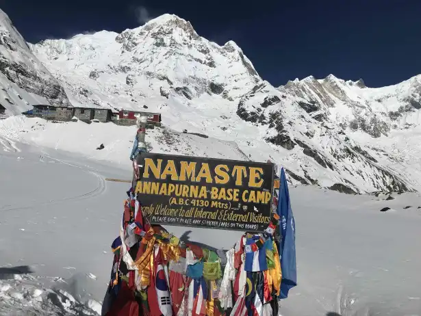
These factors bring together the Avalanche Hazard, Terrain Exposure, and Climatic Instability. First of all, the route from Deurali (3,230 m) to Machhapuchhre Base Camp (MBC) at 3,700 m represents the most critical avalanche risk along the ABC trek route. This route passes within the Annapurna Sanctuary area, which contains avalanche risk, fragile snow, and alpine terrain to a critical degree. As a result, anyone attempting this route must be aware of avalanche hazards, the dangers at Deurali, and the realities at Machhapuchhre Base Camp.
Furthermore, the elevation gain between Deurali (3,230 m) and MBC (3,700 m) also increases the risk of avalanches in winter and spring. The higher the elevation, the lower the temperature, which keeps the unstable snow intact and delays the melting phase. As such, the risk associated with avalanches, altitude exposure, and the conditions on the Himalayan mountain interact in this part.
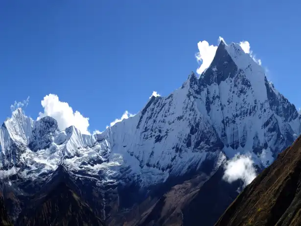
Additionally, the peripheral peaks facilitate the buildup of avalanches along the trail corridor. Annapurna South (7,219m), Hiunchuli (6,441m), and Machhapuchhre (6,993m) loom above the trail. The snow-loading slopes formed by these peaks nourish the avalanche chutes to the valleys below. In summary, the risk of avalanches, geography, and the alignment of the ABC trail can never be separated.
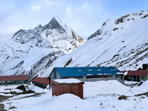
Winter at Machapuchare Base Camp (MBC) on the way to Annapurna Base Camp reveals a stark, frozen Himalayan landscape. The trail is covered in snow and ice, offering a dramatic and challenging yet breathtaking trekking experience in the heart of the Annapurna region.
n addition, the topographical formation of the Annapurna Sanctuary creates a basin-like character, where cold air and snowfall get entrapped. Such topography depresses the penetration of sunlight in the area in the afternoon and morning during the winter months. Consequently, weak layers of snow take longer to disappear along the Deurali-MBC route.
Nevertheless, certain months with weather conditions tend to be more dangerous. Avalanche risks are high because of the high snowfall in the winter months, which adds to the formation of a slab above Deurali (3,230 m) from December to February. Sudden warmth in March causes instability in the accumulated snow.At the same time, the pattern of human movements makes this vulnerable route even more so. Trekking routes tend to have people trekking at a slower pace due to altitude and cold temperatures. This further means that the more take place in this route, the higher the likelihood of being caught in an avalanche due to the increased exposure time for these treks.
In particular, rescue transportation between Deurali (3,230m) and MBC (3,700m) is difficult. Helicopter rescue costs may go beyond USD 2,000-4,000 depending upon weather conditions and availability of insurance. Avalanche danger, rescue costs, and inaccessibility can contribute to overall risk in trekking.
As a result, trekkers are monitored for any changes in snow conditions before setting out from Deurali (3,230m). Sometimes, it is left to the discretion of an experienced guide as to whether the trekker will ascend or wait. Therefore, comprehending the relevance of Deurali to MBC being an avalanche-prone area ensures improved planning during the ABC trek. The ability to understand the conditions unlocks the ability for adventurers to take heed when they encounter a section such as Deurali to MBC.
The Geographical Layout of Deurali-MBC Corridor & Natural Avalanche FunnelsI
Explore how the topographic features between Deurali and MBC influence the naturally formed avalanche pathnels beneath the influence of the Himalayan peaks.
Feature
Elevation | Avalanche Impact
Deurali
3,230 m | Entry into funnel zone
MBC
3,700 m | Maximum debris concentration
Machhapuchhre
6,993 m | Wind-loaded snow source
Worthily, the following table describes major geographical factors:
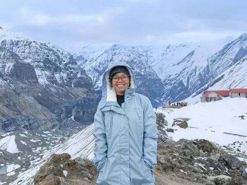
The Deurali–Machapuchare Base Camp corridor in the Annapurna region is a narrow alpine passage shaped by steep terrain and glacial history. Surrounded by towering cliffs and hanging valleys, this section naturally funnels snow and debris, making it one of the key avalanche-prone zones on the route to Annapurna Base Camp.
Here, from Deurali (3,230m) to MBC (3,700m), the corridor remains within a narrow glacial valley where the snow is channeled directly towards the trekking trail. As a direct result of this phenomenon, natural avalanche funnels are formed along the trail of ABC, and topography and avalanche danger become irrevocably intertwined along this route as well.
Lateral walls on both sides of the valley are very steep, and the slopes on each side have an inclination of well over 35 degrees. Such a condition promotes slab avalanches when heavy snowfall occurs. Hence, the area supports a combination of avalanche funnels, slope angles, and snow accumulation.
Now, the surrounding peaks also control the snow movements. Machhapuchhre (6,993 m) directs the wind-borne snow to the MBC point (3,700 m), whereas Annapurna South (7,219 m) directs the substantial snow slopes above the Deurali (3,230 m) point. Avalanche funnels, peak orientation, and wind direction are hence linked.
Further, moraines formed by glaciers introduce another element, which influences the direction debris moves. Debris left by past avalanches exhibits recurring routes crossing the trail, illustrating the pattern formed in the funnel. Therefore, the danger posed by an avalanche, the moraine formation, and the terrain’s memory help in safety analysis.
Likewise, sun intensity is very variable in the region. The south slopes take a direct sun hit in the morning, making for a warm start to the day, but the north slope retains more ice. In this region, there is a variety of funnelled avalanche paths, solar radiation influences, and snow slope aspects.
In the region near MBC, the valley narrows significantly, increasing the speed of the snow motion during a release. The increased debris impact speed increases the hazard near the trail and makes funneling, constriction, and debris kinetic energy even more important factors.
These factors incorporate avalanche funnels, elevation gain, and hazard concentration.
Crucially, snowfield-installing glacial streams cause instability in snow bases. Melt beneath the snow weakens bonding layers. Such an event leads to natural release. Avalanche funnels, glacial melt, and snowpack failure show consistency.
Actually, this results in route elevation remaining intentionally low in the valley basin. This route does not avoid higher exposure zones but rather enhances the probability of funneling. Therefore, avalanche funnels and route engineering exist together. On a final note, Deurali-MBC geographical knowledge increases mountain safety consciousness. Recognizing geographical avalanche channels helps in determining the timeline and pace of movement. Consequently, geographical knowledge, avalanche safety management, or ABC trekking safety continue to intermingle.
Understanding Avalanche Formation in the Annapurna Sanctuary Region
Know how avalanches occur in the Annapurna Sanctuary by understanding snow-pack behavior, considering prevailing weather conditions, elevations, and Himalayan terrain—pivotal for safer ABC trekking.
Three large factors drive the formation of avalanches:
Heavy snowfall above 3,000 meters
Extreme temperature fluctuations
Wind loading on alpine slopes
These factors tie together the weather patterns with the rugged Himalayan terrain.
Meanwhile, avalanche formation in the Annapurna Sanctuary begins with heavy snowfall with plenty of moisture at high altitudes. Clouds deposit dense snow above Deurali, at 3,230 meters, on steep slopes that create unstable layers. Hence, the intensities of snowfall, altitude, and avalanche probability are all interfaced with one another.
In fact, the biggest driver for snowpack stability here is temperature swings. Daylight heat from the sun warms surface layers quickly, while night-time freezing locks weaker layers beneath. The result is dangerous combinations of avalanche potential, freeze-thaw cycles, and temperature gradients.
Now, the wind also makeover how snow is deposited on exposed slopes. Strong alpine winds push snow from the ridges toward leeward faces to form wind slabs above the trekking route. Avalanche formation, therefore, is closely related to wind loading and slab development.
Further, slope angle is a very serious factor when it comes to the release of avalanches. The sanctuary has numerous slopes especially within the 30 to 45-degree range, which are angles that favor slab avalanches following storms. Thus, the slope gradient, terrain geometry, and avalanche formation are critically in alignment.
Next, ground conditions below the snow determine its bonding performance. Rocky surfaces and glacial ice provide a poor anchoring surface for snow to anchor well, and consequently allow for weak basal layers to form above frozen ground. Avalanche formation, therefore, is an interdependent process with the snow–ground interface as well as overall snow cohesion.
Finally, the surrounding peaks act as focal points to enhance snow accumulations: Annapurna South at 7,219 m and Hiunchuli at 6,441 m channel snow toward the sanctuary floor, while Machhapuchhre at 6,993 m winds block to produce deeper deposits. In short, mountain barriers, wind patterns, and snow loading all correlate with avalanche formation in this region.
An avalanche is a rapid flow of snow, ice, and debris that rushes down steep mountain slopes, often triggered by heavy snowfall or unstable snow layers. In the Annapurna region, areas near Machapuchare Base Camp and the route toward Annapurna Base Camp can become vulnerable in winter and early spring, especially in steep corridors like the Deurali–MBC section.
Not every day does an avalanche behave the same. The type of precipitation makes a difference: wet snow tends to produce bigger slides in spring when it warms; after a heavy winter storm, it's dry, layered slabs that slide most often. So, how avalanches form, what kind of precipitation you get, and the season all shape the risk.
In glacial valleys, cold air gets trapped in the sheltered bowls, slowing how snow stabilizes. Those weak layers stick around longer than they would on exposed slopes, which means avalanche risk climbs in these valleys. The combination of cold-air pooling and the valley's shape makes avalanches more likely there.
Having said that, most large avalanches here aren't started by people trampling around. Natural releases dominate because of the scale of the landscape. Still, trekkers do run a risk when they're underneath potential release zones, so the link between natural triggers, avalanche formation, and trail exposure matters. In the end, understanding the formation of an avalanche in the Annapurna Sanctuary sharpens risk awareness by helping with better timing and safer choices. So, avalanche science, trekking safety from ABC routes, and careful planning are crucial for responsible trekking.
Large Avalanche-Prone Areas Deurali to Bagar to Machhapuchhre Base Camp
Analysis of the major avalanche prone areas from Deurali, Bagar, and Machhapuchhre Base Camp, based on elevation, land funneling, and risk hours during different seasons.
Within the Annapurna Sanctuary, there are a number of well-named avalanche zones. A quick overview of those is given below:
Location: Deurali, 3,230 m — the trail slips right into an avalanche corridor.
Location: Bagar, 3,310 m — a funnel-shaped debris field.
Location: MBC, 3,700 m - many chutes here, all converge to one.
These places blend avalanche danger with how much uphill you've gained and traps the terrain can throw at you.
From Deurali (3,230 m) to Bagar (3,310 m), this marks the first serious introduction to avalanches. The snow walls tower directly above the trail and avalanche paths cross over and over again. It is here that alignments, exposure to danger, and avalanche paths converge.
Continuing into Bagar (3,310 m), the land narrows within a hanging valley. Avalanche paths compress in this constriction to funnel the snowled avalanche material directly to the bottoms of the valleys through the concentration of the snowavalanche paths. In this case, there is an increased hazard in the danger zones.
Aside from Bagar, the exposed portion has trekkers traversing over different avalanche paths. Natural shelter sites are negligible in this location, and wind-blown snow usually collects above the trekker paths. In this area, wind slabs, exposure, and avenues of avalanches compound the danger potential.
To reach the Machhapuchhre Base Camp (3,700 m) represents the maximum level of peril. There are a number of avalanche chutes on the mountain of Machhapuchhre (6,993 m) which are close to the route corridor.
Here, the timing of weather events is a highly important, daily factor. Crossing during the morning hours will restrict warming-induced releases, while afternoon warming will enhance the chances of wet avalanches. Hence, changes in daily temperatures, risk areas, and trekking times affect safety.
Meanwhile, the historical avalanche deposition indicates the existence of persistent hazard patterns. Historical deposits of debris are found around Bagar (3,310 m) and below the base camp of Machhapuchhre (3,700 m). In summary, avalanche danger areas, terrain memory, and safety analysis correspond with these historical indicators.
Rescue realities make things even tougher here. Evacuating by helicopter can run roughly USD 2,000–4,000, and weather often drags out delays once cloud cover moves in. All of this pushes the risk factor higher when you combine danger with cost and remoteness.
The journey from Deurali to Machapuchare Base Camp follows a dramatic alpine corridor carved between steep Himalayan slopes. As trekkers ascend, the landscape becomes more rugged and snowy, with narrowing valleys leading deeper into the heart of the Annapurna Base Camp region.
Therefore, guides often keep trekkers at Deurali, which is at 3,230 meters, when the risk is high. Safety decisions often swing toward protecting the group over rushing the itinerary. This decision is an intersection of avalanche risk, professional judgment, and trek management. Ultimately, the knowledge of where big avalanche areas lie sharpens survival awareness. With that knowledge, trekkers are more apt to heed warnings and time their moves wisely. In short, avalanche zoning, trek safety practices, and informed travel decisions remain crucial in the Annapurna Sanctuary.
Seasonal Patterns of Avalanche: Winter Snowfall and Wet Slides in Spring
Learn how winter snow accumulation and springtime wet slides create different avalanche patterns in the Annapurna Sanctuary-affecting safety between Deurali and Machhapuchhre Base Camp.
A quick seasonal contrast underlines the variation:
Spring: wet slides; solar heating; meltwater intrusion.
These contrasts map directly to avalanche patterns, seasonal hazards, and trekking choices. Actually, the avalanche behavior in the Annapurna Sanctuary develops during winter after consistent snowfall above Deurali at 3,230 meters. With a cold temperature, it tends to lock loose snow layers into place, making them fragile on steep inclines. In its result, it has a strong interaction between cold snowpack, winter conditions, and high elevations, which feed on avalanches.
From December to February, dry slab avalanches dominate. The wind stompers powder from ridges onto lee slopes, building dense slabs over weaker layers. This formula—winter pattern, wind load, and slab instability—combines to form a deadly concoction.
Limited winter sunlight slows the stabilization of new snow. Cold air trapped in the Annapurna Sanctuary bowl keeps weak layers active for weeks. Consequently, winter avalanche patterns include cold-air pooling and delayed bonding.
Here, during ABC Trek in peak winter and spring, alternative route is opened from Deurali to the main trail near Machhapuchhre Base Camp through the other side via wider valley. So, that trekkers can walk past Bagar area safely without the risks of avalanches and rock fall.
Likewise, winter snowfall frequency also increases the risk, since storms recycle and continue building layers of instability. Every new storm stresses the old snowpack, increasing winter avalanche potential along with storm cycles and layered instability.
By March, spring changes everything. With warming temperatures, snowpack rapidly changes as meltwater percolates into deeper layers; wet snow avalanches become the primary hazard. Spring patterns at or below the elevation of melting snow and rising temperatures.
Wet slides in spring often release in the afternoons due to the need for solar heating on south-facing slopes. The heat weakens bonds near the snow surface and increases the likelihood of a release. Spring avalanche patterns, therefore, increase with solar exposure and wet instability.
Notably, ABC Trek in spring avalanches move slower but carry more mass, and wet debris flows race across valley floors. These slides threaten trails near Bagar (3,310 m), so spring patterns, heavy debris, and the shape of valley funnels all push danger upward. Therefore, there is a temporary trail from Deurali to connect the main trail near Machhapuchhre Base Camp to avoid the risk of avalanche.
During the walk from Deurali to the main trail near Machhapuchhre Base Camp, you can see some temporary huts and the resting places where local people transfer their cattle to the safe zones during the avalanches.
As always, timing sets the seasonal safety bar. Traveling in the early hours reduces exposure to springs' wet slides, while midday movement ramps up risk markedly. So avalanche behavior, trekking plans, and the daily heating cycle remain tightly connected.
Consequently, hiring guides adjust departure times according to the season. Winter demands post-storm checks; early crossings are favored in spring. In other words, guiding tactics, avalanche patterns, and risk management all collide. In the end, understanding seasonal avalanche behavior promotes safety on the ABC trek. The pattern knowledge helps trekkers choose months that are appropriate, and with seasonal awareness, forecasting, and careful planning, lives are protected in the Annapurna Sanctuary.
Real Trail Experiences: Past Avalanche Incidents and Near-Miss Stories
The Deurali to Machhapuchhare Base Camp trek has seen some close calls and tragedies related to avalanches, which can provide lessons for trekking to ABC safely.
Location
Elevation | Incident Type
Deurali
3,230 m | track blockade
Bagar
3,310 m | Near-miss release
MBC
3,700 m | Wet debris flow
A quick snapshot of reported experiences in the table:
These entries tie avalanche events to height and exposure.
To start with, tracing back avalanches between Deurali and MBC, starting at 3,230m and ending at 3,700m, one can observe a certain danger that re-emerges repeatedly. Winter snowfall has triggered a number of avalanches on this trail when least anticipated.
Locally, guides mention a series of close calls around Bagar (3,310 m). Avalanche incidents occur just minutes after trekkers cross the dangerous areas, emphasizing the unpredictability of snow conditions. In this regard, the series of close calls at Bagar indicates that risks associated with timing and terrain are essential lessons.
Moreover, in Bagar Area there are occasional rock fall along with avalanches during the time for hiking from Deurali to MBC.
A serious event involved the sweep of debris over the trail as it passed below the mountain Machhapuchhre (6,993 m). Trekkers were saved from harm by their decision to halt at the village Deurali (3,230 m), which saved their lives.
In fact, "In spring, there are wet slides that come down through valleys near MBC (3,700 m)." Such occurrences usually happen during warm afternoon hours, accompanied by a deep rumble noise before discharge. Practical experiences emphasize the need to listen for warning signals and learn about wet avalanche characteristics.
Incidents are more likely to be delays than injuries, though the dispersal of debris makes it difficult to avoid them. Nevertheless, the earlier one moves, the less one is exposed to the risk, relating the history of avalanches, timing, and protection.
Here, helicopter rescue operations are a less common occurrence, costing dearly after such events, with evacuation fees ranging from USD 4,000-6,000. Delays caused by weather variations make such incidents even more challenging, thus making avalanches, rescue costs, and inaccessibility compound the situation.
Specifically, guides record every year's avalanche history, and such records are what dictate how we route for the current season. The moment a path keeps coming up, that is an indication of a permanent hazard zone. In other words, real experiences, terrain memory, and risk mapping shape how we go about the trek.
So, it's to the trekkers' advantage to pay attention to local advice. Itineraries are modified by guides in light of recent happenings. Disregarding warnings only enhances danger. The avalanche stories, local wisdom, and careful decision-making come together for a conclusion. At the end, real trail experiences deepen avalanche awareness. Past incidents teach respect for the raw power of nature. By learning from history, prioritizing trek safety, and traveling responsibly, Himalayan journeys are safer.
Weather, Snow Condition, and Time-of-Day Factors that Influence Crash Risk
Understand the impact of weather patterns, snow conditions, and the time of day on avalanche risk from Deurali to Machhapuchhre Base Camp in the Annapurna Sanctuary.
Below is a brief summary of the core risk factors:
Snowfall: Heavy snowfall in the evening, high slab stability
Temperature: Fast warming, increases risk of wet slide.
Time: Afternoon, peak instability
These include the combination of weather force, snow condition, and time. Initially, the prevailing patterns of the weather on ABC Trek are one of the forces that determine the potential for avalanches within the Annapurna Sanctuary. Snow falling too quickly beyond the point at Deurali (3,230 m) threatens to fall on its own accord because the storms come from the Bay of Bengal with snow that is saturated with moisture.
Here, the temperature variations during a day also influence the snow conditions. A weak layer on the snow can be preserved when it gets cold at night; on the other hand, it gets destabilized very easily when it gets warm during the daytime due to a rapid rise in temperature.
Likewise, clouds also make an issue, as they determine how solar radiation reaches the slopes. In areas where the sun shines brightly, it warms the surface of the ice, and this accelerates the process of bond failure between ice masses. In summary, solar radiation, melt, and Avalanche danger occur in rhythm.
Moreover, wind is also a factor that has a snow-pack redistributive effect. Strong alpine vents the snow to the slopes that lie below the trail. The resulting wind slab stays in a position that is characterized by instability for rather long periods. Wind load, slab formation, and avalanche formation therefore go side by side.
Here, it also matters in terms of snow conditions. South-facing slopes in Bagar on the Annapurna Base Camp Trail, which are around 3,310 m, get more warm compared to north-facing ones that remain cold. This leads to large variations in terms of snow conditions, orientation, and avalanche patterns between the eastern and western counterparts.
Similarly, the time of day also impacts exposure to risk. The morning tends to have a more solid and cold snowpack, while a warm. This afternoon tends to increase the possibility of wet avalanches, thereby linking timing of avalanche, snow melting, and time of day.
In spring, the danger of a normal day increases in variations. In the initial stages of spring, the danger is a hard snowmass, and as midday approaches, it melts rapidly. This meltwater seeps down, and thus the danger from the time of day, warmth of spring, and wet slides increases.
In the high altitude of Annapurna Region, weather predictions may not always be accurate. Local communities rely on what they can see with their own eyes rather than computer simulations. Mountain guides read the signs from clouds and winds to figure out what is going on. Thus, weather smarts and ground truth remain tied closely together.
Thus, the format of trekking from Deurali to Machhapuchhre Base Camp gets modulated according to the conditions. Early departure is the key to avoiding the risk of landslides when it comes to slopes; chances are stacked against the later the departure is. Thus, the conditions regarding the weather, timing, and avalanche risks collide. In the end, being able to understand the interaction of weather, snow conditions, and the time of day is helpful for decision-making in general. It is always important to exercise this knowledge for safer travel when crossing the exposed areas. This fact still plays a crucial role in the trekking process of the Annapurna Sanctuary.
Safe Trekking Practices While Crossing Open Avalanche Slopes
Practical tips for safely crossing open avalanche slopes between Deurali and Machhapuchhre Base Camp, including information on timing, spacing, and risk awareness.
Along with this, the following practices ensure crossings are made safely:
Early, especially when it is cold
Works on cross-sloping one person at a time
Do what the GUIDE says to the letter.
Do not linger while walking past Bagar Area.
Be careful while walking past Bagar Area to avoid possible avalanches and rockfall.
These traditions infuse avalanche awareness, discipline, and protection with every move. Actually, safe trekking starts with the choice of the right moment to move across slopes that may avalanche. Early crossings tend to yield firmer snow, and cooler temperatures keep snow from shifting as easily. In short, timing, snow stability, and avalanche risk are inextricably linked.
Moreover, another important protection is spacing the group. Individuals should cross one at a time through open sections, which helps prevent numerous casualties if any kind of slide occurs. This is how group management, spacing, and avalanche safety all come together in one.
The regular pace matters: the slower the movement or stopping in one place, the more time people are staying under unstable parts of the rock face, while smooth and continuous movement reduces exposure time. Pace and exposure duration stay connected with safety discipline.
Here, guides naturally head to the lowest, most-protected line across a slope from Deurali to MBC. They will often use valley-bottom routes to avoid exposed overhead chutes, minimizing their exposure to a hit. Route choice, terrain awareness, and avalanche mitigation all come into play with these considerations.
Further, visual snow assessment adds another layer of safety. Watch out for signs, such as new debris, whooping noises in the snow, or hollow sounds, which can show that it is unstable. The ability to observe snow conditions, recognize hazards, and take precautions goes hand in hand.
Likewise, communication during crossings between Deurali to MBC is key. Obvious signals are used to control spacing and motion; calm, attentive listening for natural sounds of an avalanche can cue the group. In general, strong group communication, heightened awareness, and coordinated safety boost overall effectiveness.
In fact, it's also important to remain prepared equipped with right gear while walking from Deurali to MBC. When you know that you're properly equipped, you can be more prepared for the mountain environment, such as having trekking poles that can help with balance when hiking on icy surfaces, as well as emergency tools that ensure help is available in case of an emergency. Essentially, being safe, having balance control, and being prepared for an emergency are interrelated concepts.
Guides may err on the side of caution in exposed spots. Stopping at Deurali (3,230 meters) may save one from exposure, and that's a lesson that caution can be more important than timetables.
If you disregard safety guidelines, and the risk of accidents increases. Many accidents have occurred while passing through Bagar from Deurali to Machhapuchhre Base Camp because of rushed decision-making. Disciplined individuals reduce unnecessary exposure. Thus, safe practices, self-control, and avalanche avoidance continue to be important. Therefore, to be safe while trekking in avalanche-prone slopes, the key is to be alert and self-disciplined. Knowing what to do translates to walking through the mountains calmly. Hence, practicing safe trekking methods, demonstrating trekking responsibility, and observing Himalayan conditions are responsible steps to safer treks.
The Role of Local Guides, Teahouse Advice, and Risk Assessment Every Day
Get knowledge on how local guides, teahouse information, and daily risk assessments reduce the risk of an avalanche from Deurali to Machhapuchhre Base Camp on the ABC trek.
Critical components to ensure effective daily risk evaluation are the following:
Recent avalanche activity reports.
Snowpack surface testing.
Weather trend analysis.
All these elements influence day-to-day risk assessment, avalanche prediction, and enhanced decision-making. Meanwhile, the first thing to note here is that it's the local guides that play the crucial role with regard to avalanche risk when it comes to the Deurali pass at 3,230m and MBC pass at 3,700m. Their knowledge of the mountain behavior and avalanche risk patterns comes from numerous crossings. In sum, their expertise and knowledge of avalanche risk and the route are closely linked.
After that, the daily snow conditions evaluation is carried out by the guides prior to departure. The guides take into consideration the snowfall in the previous hours, the wind loading, as well as the variations in temperatures during the night. Visual indicators are also utilized in the evaluation to identify the instability on the slab above the trail.
Moreover, guides also interpret the movement of the weather based on natural indicators. Cloud speed, wind direction, and changes in humidity levels are involved in the process. Computerized forecasts may assist, but they will never substitute human judgment. This means that forecast interpretation and avalanche forecasting will always remain intertwined.
In addition, there is safety information coming from the teahouse operators too. The operators track avalanches around Bagar (3,310 m) and MBC (3,700 m). The reports frequently describe overnight avalanches and trail blockages. As such, the information from the teahouses and local observation can be valuable.
Nevertheless, the process of daily risk evaluation involves combining different information streams. Guides consult teahouse staff, porters, and other climbing parties. This shared knowledge gives a clearer risk perspective. Thus, teamwork, daily risk evaluation, and awareness of avalanches enhance decision-making.
Thirdly, decision timing depends on local advice. The teahouse owners recommend an early departure in spring. The guide confirms the safe window for crossing accordingly. Thus, decision timing, local advice, and risk mitigation are interlinked.
In reality, route adjustment from Deurali to Machhapuchhre Base Camp is another frequently used safety measure. The guides can adjust crossing lines to avoid new debris areas. Moreover, small route variations can minimize exposure to risk. Therefore, route adjustment and terrain awareness, together with avalanche safety measures, can be used collectively.
Here, guides also add worth beyond just showing the way. The cost of engaging a qualified guide will add up to between 25-35 USD per day for a licensed guide. All these factors—guide’s fee, investment in safety measures, and prevention of dangers—make the guides invaluable.
Consequently, solo trekkers are more prone to exposure risk of avalanche between Deurali to Machhpuchhre Base Camp. This is because they tend to mistake timing and snow conditions. Local wisdom can fill this knowledge gap. There is a connection between guide dependence, teahouse knowledge, and safety awareness. Nevertheless, guides and teahouses are always crucial to avalanche safety. Their knowledge and wisdom protect adventurers from unseen dangers. Local knowledge and expert insight prevent disasters and facilitate safe travel to Machhapuchre Base Camp.
Conclusion: Reducing Avalanche Risk from Deurali to MBC
Learn to minimize avalanche risks while trekking from Deurali to Machhapuchre Base Camp with some planning and insight into trekking techniques.
Equally, these methods reduce the risk of avalanches effectively:
Hire licensed local guides
Cross sloping starts with one slope at a time
Follow teahouse safety guidelines
Do not delay while crossing Bagar Area
Be alert of rock fall and avalanches while walking in Bagar Area
Ask local people if they have built a new trail for the safety
This mix offers a combination of avalanche prevention, discipline, and local knowledge.
First, avalanche risk reduction on this trajectory between Deurali (3,230m) and MBC (3,700m) begins with being alert. Let trekkers remain cautious because this section can be labeled as the most perilous on this ABC trek. Even here, you will still be exposed, and planning, alertness, and preparedness are needed.
Second, awareness of the territory can reduce unnecessary risk of exposure. The avalanche slopes flow down from the peaks of Machhapuchhre (6,993m) and Annapurna South (7,219m), channeling the detritus into the valley floor. By familiarizing oneself with the terrain, risk assessment of the area, and sticking to the path, one can minimize risk.
Third, seasonality plays a significant role in influencing safety results. There are dry slab avalanches during winter when the snow is wet from a storm. There are wet avalanches during spring after a warm afternoon. It thus means being attuned to the season and knowing the avalanche cycles to stay safe.
Specifically, Spring ( March-May) is the main season to cause the risk of avalanches to the trekkers between Deurali to Machhapuchhre Base Camp.
Fourth, regular weather checks enhance decision-making. Snowfall at night, wind pressure, and increasing temperatures are used as risk factors. Ground-level reality can surpass internet weather predictions. So, it’s important to remain alert and aware of the weather and snow conditions.
Fifth, how one treks matters for exposure to avalanches. Trekkers who get an early start reduce exposure to warming-related instability. Trekkers who keep going limit their exposure time to slopes. Trekkers need trekking discipline, trekking timing, and knowledge of how to avoid avalanches.
Finally, the element of professional advice has always remained a foundation for being safe on these routes. Guides are able to read environments correctly and change plans accordingly. The most important factor for them is ensuring that they are safe rather than reaching their destination quickly.
Worldly chatter is what refines real-time situational awareness. Sounds of overnight avalanches and glimpses of debris help direct morning activity. Ignoring such local advice elevates risks. Therefore, falling back on local advice, shared knowledge, and safety culture is anything but optional.
Preparing for emergency situations reduces the risks involved when catastrophe strikes. Rescue activities at MBC (3,700m) remain expensive and are also slow. Helicopter evacuation may cost between USD 2,000 and 4,000. This explains the importance of prevention and being informed of the costs involved to avoid taking unnecessary risks.
So, the trekkers who have knowledge make better decisions, every single day while they are on Annapurna Base Camp Trek. They nudge the schedule when required instead of going ahead according to their impulse. Knowledge overpowers the need to take pressure-driven action. Knowledge, flexible action, and reduced avalanche risks work side by side. Ultimately, avalanche danger from Deurali to MBC can be mitigated only by respecting nature and planning ahead of the trek for the particular day. The mountains dictate the pace, and not the trekking plan. Knowledge, patience, and prudent hiking ensure that holidays in the Annapurna Sanctuary remain a memorable one.
FAQs for " Avalanche Risk Zone Between Deurali to MBC "
1. What is the Avalanche Risk Zone Between Deurali and MBC? The part of the trail from Deurali to Machapuchhre Base Camp is really bad for avalanches. This is because the valleys are narrow and the snow from the slopes of Machhapuchhre and the surrounding mountains comes down right onto the trail. We have been guiding people in the Annapurna region for a time so we know that this area is very dangerous. If you understand the geography of this place you can make choices and have a more responsible trek.
2. Why is the Deurali to Machapuchhre Base Camp Trail So Dangerous? This trail is bad because it goes through a valley where the paths of the avalanches meet. The slopes are steep the snow is loaded with wind. The rocks are not stable. Our team of experts has guided people safely by being careful when we cross these areas. If you are prepared and know the area you can manage the risks. Still enjoy the beauty of the place.
3. When is the Highest Avalanche Risk on ABC Trek? The risk of avalanches is highest after it snows a lot in the winter and in the spring when the sun's warm and the snow gets wet. From December to May the conditions change every day. We think it is an idea to check the weather all the time and use different routes when we need to. This is how we have kept our trekkers safe for years.
4. How Do Avalanches Form in the Annapurna Sanctuary? Avalanches happen because of snow changes in temperature and wind on the slopes. When the snow freezes and thaws it gets weak. The wind makes it even more dangerous. We know a lot about the conditions in the Himalayas so we can tell when it is not safe. This helps the trekkers plan their trip and avoid getting in harms way.
5. What Are the Main Avalanche Prone Areas from Deurali to MBC? There are an areas that are really bad for avalanches like the part where you enter Deurali, the narrow part at Bagar and the areas near Machapuchhre Base Camp. The snow walls are really high above the trail. There is often a lot of debris there. We have guided people through these areas times so we teach them how to recognize the dangers and be safe.
6. How Does Season Affect Avalanche Danger on ABC Trek? In the winter the snow is dry. Can slide easily because of the wind. In the spring the sun makes the snow wet. It can slide too. We have guided people safely in both seasons by changing our schedule and using trails, for a short time. This means that you can trek at the time and be safe.
7. What Safety Tips Help Cross Avalanche Zones Safely? Crossing avalanche zones early in the morning is an idea because the snow is stable then. It is also an idea to move one person at a time and maintain a steady pace. Follow your guides instructions carefully. Do not stop in areas that are exposed. Our team of guides always follows these safety tips. They have helped many trekkers cross avalanche zones safely on this route.
8. Should I Trek Deurali to MBC Without a Guide? We think it is an idea to trek Deurali to MBC without a guide. A local guide knows the area well and can tell you about any dangers. They know about the conditions of the terrain in time and can show you alternative paths if needed. Our guides have a lot of experience. Have helped many people cross safely. Trekking alone can be very risky in this area.
9. What Weather Conditions Increase Avalanche Risk? Heavy snowfall, weather, strong winds and sunlight on south-facing slopes can all increase the risk of an avalanche. Our team checks the weather every day to stay informed. We use our knowledge of the area to make decisions and cross avalanche zones safely. Understanding the weather helps us plan treks through the Deurali-MBC section.
10. Have There Been Avalanche Incidents on This Route? Yes there have been avalanches on this route in the past. Some of these incidents happened near Bagar and MBC. Our team learns from these incidents. Uses the knowledge to improve our safety protocols. We use this experience to guide trekkers and prevent similar incidents from happening again.
11. What is the Best Time of Day to Cross High-Risk Sections? The best time to cross high-risk sections is early in the morning. The temperatures are lower. The snow is more stable then. It is not an idea to cross in the afternoon especially in the spring. Our guides have found that crossing in the morning is the time. We plan our treks accordingly to minimize the risk of an avalanche.
12. Are There Alternative Routes to Avoid Avalanches? Yes during times of risk our team opens temporary trails on the wider valley side from Deurali to MBC. These trails avoid the dangerous areas. Our guides know these routes very well and use them to keep our treks safe and enjoyable.
13. How Can I Prepare for Avalanche Risks Before the Trek? To prepare for avalanche risks you should pack clothing check the weather forecast and choose a reputable tour operator. It is also important to listen to the -trek briefing and be physically and mentally prepared. Our team provides preparation to help you feel confident and safe on the trek.
14. What Should I Do If an Avalanche Occurs? If an avalanche happens stay calm. Try to move sideways if you can. Look for something to hide behind and call for help. Follow your guides instructions. Let them lead you to safety. Our teams are trained to respond safely in case of an avalanche.
15. Is the ABC Trek Safe for Beginners Considering Avalanche Zones? Yes the ABC trek can be safe, for beginners if they have a guide and are physically fit. It is also important to time the trek to avoid high-risk periods. Our team has helped many beginners complete the trek safely by managing the risks. We believe that with the guidance anyone can enjoy this trek safely.