[{"name":"Everest Base Camp Helicopter Tour","duration":"1","image_url":"https:\/\/www.havenholidaysnepal.com\/storage\/trip-galleries\/1\/thumb_6cd53005d75a86e373d31419d1b14d78.webp","offer_price":1195,"url":"https:\/\/www.havenholidaysnepal.com\/trips\/everest-base-camp-helicopter-tour"},{"name":"Everest Mountain Flight","duration":"1","image_url":"https:\/\/www.havenholidaysnepal.com\/storage\/trip-galleries\/4\/thumb_3b0b4f1d6f72b0ad224daf4752f2c6e0.jpg","offer_price":285,"url":"https:\/\/www.havenholidaysnepal.com\/trips\/everest-mountain-flight"},{"name":"Everest Short Trek","duration":"9","image_url":"https:\/\/www.havenholidaysnepal.com\/storage\/trip-galleries\/5\/thumb_BXPP3621.JPEG0.02033800 1727957098.webp","offer_price":895,"url":"https:\/\/www.havenholidaysnepal.com\/trips\/everest-short-trek"},{"name":"Gokyo Valley Trek","duration":"12","image_url":"https:\/\/www.havenholidaysnepal.com\/storage\/trip-galleries\/6\/thumb_10bc469b14731f23d3ce84a7092ad53f.jpg","offer_price":1195,"url":"https:\/\/www.havenholidaysnepal.com\/trips\/gokyo-valley-trek"},{"name":"15 days Annapurna Base Camp Trek","duration":"15","image_url":"https:\/\/www.havenholidaysnepal.com\/storage\/trip-galleries\/7\/thumb_87d1533bc45faf070990aef0579e4be4.jpg0.81855100 1728285496.webp","offer_price":785,"url":"https:\/\/www.havenholidaysnepal.com\/trips\/15-days-annapurna-base-camp-trek"},{"name":"Nepal Pilgrimage Tour","duration":"14","image_url":"https:\/\/www.havenholidaysnepal.com\/storage\/trip-galleries\/8\/thumb_02c3bcf2ad2e8a4c1703e90ae747b5f1.jpg","offer_price":1475,"url":"https:\/\/www.havenholidaysnepal.com\/trips\/nepal-pilgrimage-tour"},{"name":"UNESCO World Heritage Site Tour","duration":"10","image_url":"https:\/\/www.havenholidaysnepal.com\/storage\/trip-galleries\/9\/thumb_unesco-world-heritage-site-Lumbani-temple-buddhists-hindus-kathmandu-nepal0.36988600 17347617740.93089500 1737469667.webp","offer_price":715,"url":"https:\/\/www.havenholidaysnepal.com\/trips\/unesco-world-heritage-site-tour"},{"name":"Island Peak Climbing","duration":"16","image_url":"https:\/\/www.havenholidaysnepal.com\/storage\/trip-galleries\/11\/thumb_Island peak0.53947000 1734692503.webp","offer_price":2495,"url":"https:\/\/www.havenholidaysnepal.com\/trips\/island-peak-climbing"},{"name":"Upper Mustang Trek","duration":"18","image_url":"https:\/\/www.havenholidaysnepal.com\/storage\/trip-galleries\/12\/thumb_upper mustang 7 Oct-2024.jpg0.95398900 1728286166.webp","offer_price":2995,"url":"https:\/\/www.havenholidaysnepal.com\/trips\/upper-mustang-trek"},{"name":"Annapurna Circuit Trek","duration":"16","image_url":"https:\/\/www.havenholidaysnepal.com\/storage\/trip-galleries\/15\/thumb_tibetan-flags.jpg0.04843900 1728289138.webp","offer_price":985,"url":"https:\/\/www.havenholidaysnepal.com\/trips\/annapurna-circuit-trek"},{"name":"Gosainkunda Lake Trek","duration":"10","image_url":"https:\/\/www.havenholidaysnepal.com\/storage\/trip-galleries\/16\/thumb_5A8083B3-C007-41A8-853F-D0C37C97D235_1_105_c.jpeg0.52581200 1731845258.webp","offer_price":595,"url":"https:\/\/www.havenholidaysnepal.com\/trips\/gosainkunda-lake-trek"},{"name":"Zip-lining in Pokhara and Dhulikhel","duration":"1","image_url":"https:\/\/www.havenholidaysnepal.com\/storage\/trip-galleries\/18\/thumb_215f765e2ebc995dd5c800b4bfdbacc3.jpg","offer_price":82,"url":"https:\/\/www.havenholidaysnepal.com\/trips\/zip-lining-in-pokhara-and-dhulikhel"},{"name":"Annapurna Heli Tour","duration":"1","image_url":"https:\/\/www.havenholidaysnepal.com\/storage\/trip-galleries\/19\/thumb_d71a6bbb9fd4da8d1b567a5cdbdec85d.jpg","offer_price":555,"url":"https:\/\/www.havenholidaysnepal.com\/trips\/annapurna-heli-tour"},{"name":"Paragliding in Pokhara","duration":"1","image_url":"https:\/\/www.havenholidaysnepal.com\/storage\/trip-galleries\/20\/thumb_de788d2dd9726783431f882c007efae1.jpg","offer_price":65,"url":"https:\/\/www.havenholidaysnepal.com\/trips\/paragliding-in-pokhara"},{"name":"Ultra-Flight in Pokhara","duration":"1","image_url":"https:\/\/www.havenholidaysnepal.com\/storage\/trip-galleries\/21\/thumb_e27a9fb572a5c21611bb2a3c18e4b8f0.jpeg","offer_price":175,"url":"https:\/\/www.havenholidaysnepal.com\/trips\/ultra-flight-in-pokhara"},{"name":"Sarangkot Hiking","duration":"1","image_url":"https:\/\/www.havenholidaysnepal.com\/storage\/trip-galleries\/22\/thumb_100ef822fea19987166c6c1366215f15.jpg","offer_price":55,"url":"https:\/\/www.havenholidaysnepal.com\/trips\/sarangkot-hiking"},{"name":"Mera Peak Climbing","duration":"18","image_url":"https:\/\/www.havenholidaysnepal.com\/storage\/trip-galleries\/24\/thumb_d16ae3895f678cf26ffbf2455f541fb5.jpg0.31883400 1732617790.webp","offer_price":2475,"url":"https:\/\/www.havenholidaysnepal.com\/trips\/mera-peak-climbing"},{"name":"Lower Dolpo Trek","duration":"18","image_url":"https:\/\/www.havenholidaysnepal.com\/storage\/trip-galleries\/26\/thumb_Dolpo Galary - 1.JPG0.37725200 1727939952.webp","offer_price":2995,"url":"https:\/\/www.havenholidaysnepal.com\/trips\/lower-dolpo-trek"},{"name":"Nagarkot Sunrise\/Sunset Tour","duration":"1","image_url":"https:\/\/www.havenholidaysnepal.com\/storage\/trip-galleries\/27\/thumb_5147a5532644283a380f2e86f3857c13.jpg0.17748000 1728488108.webp","offer_price":30,"url":"https:\/\/www.havenholidaysnepal.com\/trips\/nagarkot-sunrise-sunset-tour"},{"name":"16 day Everest Base Camp Trek","duration":"16","image_url":"https:\/\/www.havenholidaysnepal.com\/storage\/trip-galleries\/28\/thumb_IMG_4311.JPG0.64984800 1727942213.webp","offer_price":1475,"url":"https:\/\/www.havenholidaysnepal.com\/trips\/16-day-everest-base-camp-trek"},{"name":"Ghorepani Poon Hill trek with Jungle Safari and Trishuli River Rafting -13 days","duration":"13","image_url":"https:\/\/www.havenholidaysnepal.com\/storage\/trip-galleries\/29\/thumb_Ghorepani Poon hill.jpg0.48460800 1728281439.webp","offer_price":795,"url":"https:\/\/www.havenholidaysnepal.com\/trips\/ghorepani-poon-hill-trek-with-jungle-safari-and-trishuli-river-rafting--13-days"},{"name":"Mardi Himal Trek","duration":"12","image_url":"https:\/\/www.havenholidaysnepal.com\/storage\/trip-galleries\/30\/thumb_s1.jpg0.62112600 1728200721.webp","offer_price":795,"url":"https:\/\/www.havenholidaysnepal.com\/trips\/mardi-himal-trek"},{"name":"Langtang Valley Trekking","duration":"10","image_url":"https:\/\/www.havenholidaysnepal.com\/storage\/trip-galleries\/31\/thumb_IMG_4702.JPG0.84916500 1727958504.webp","offer_price":685,"url":"https:\/\/www.havenholidaysnepal.com\/trips\/langtang-valley-trekking"},{"name":"Real Adventure Tour in Nepal","duration":"9","image_url":"https:\/\/www.havenholidaysnepal.com\/storage\/trip-galleries\/32\/thumb_ebd1b8cc78d90abe8b9003dd9a2f25bf.jpg0.82151300 1728213516.webp","offer_price":695,"url":"https:\/\/www.havenholidaysnepal.com\/trips\/real-adventure-tour-in-nepal"},{"name":"Luxury Tour in Nepal","duration":"10","image_url":"https:\/\/www.havenholidaysnepal.com\/storage\/trip-galleries\/33\/thumb_8574e61b252b18676b042caf30d830df.jpg","offer_price":1675,"url":"https:\/\/www.havenholidaysnepal.com\/trips\/luxury-tour-in-nepal"},{"name":"Luxury Everest Panorama Trek With EBC Heli Sightseeing","duration":"8","image_url":"https:\/\/www.havenholidaysnepal.com\/storage\/trip-galleries\/34\/thumb_URZL2397.JPEG0.01209600 1728027820.webp","offer_price":2395,"url":"https:\/\/www.havenholidaysnepal.com\/trips\/luxury-everest-panorama-trek-with-ebc-heli-sightseeing"},{"name":"13 day Everest Base Camp Trek with Helicopter","duration":"13","image_url":"https:\/\/www.havenholidaysnepal.com\/storage\/trip-galleries\/35\/thumb_IMG_4292.JPG0.70131500 1728029276.webp","offer_price":2095,"url":"https:\/\/www.havenholidaysnepal.com\/trips\/13-day-everest-base-camp-trek-with-helicopter"},{"name":"Manaslu Circuit Trek","duration":"16","image_url":"https:\/\/www.havenholidaysnepal.com\/storage\/trip-galleries\/36\/thumb_Mt Manaslu 03-Oct-2024.jpg0.65804900 1727938470.webp","offer_price":955,"url":"https:\/\/www.havenholidaysnepal.com\/trips\/manaslu-circuit-trek"},{"name":"Kanchenjunga Base Camp Trek","duration":"21","image_url":"https:\/\/www.havenholidaysnepal.com\/storage\/trip-galleries\/37\/thumb_Kanchanjunga Trek -!.jpg0.54744400 1727938497.webp","offer_price":2275,"url":"https:\/\/www.havenholidaysnepal.com\/trips\/kanchenjunga-base-camp-trek"},{"name":"Ganesh Himal and Sing-La Trek","duration":"18","image_url":"https:\/\/www.havenholidaysnepal.com\/storage\/trip-galleries\/38\/thumb_Ganesh Himal slider-1.jpg0.43764500 1727937722.webp","offer_price":2975,"url":"https:\/\/www.havenholidaysnepal.com\/trips\/ganesh-himal-and-sing-la-trek"},{"name":"Island Peak Climb with Everest Base Camp Trek","duration":"21","image_url":"https:\/\/www.havenholidaysnepal.com\/storage\/trip-galleries\/39\/thumb_2be428730fe83525bc85a010564f99de.jpg","offer_price":2750,"url":"https:\/\/www.havenholidaysnepal.com\/trips\/island-peak-climb-with-everest-base-camp-trek"},{"name":"Students' Adventure Tour in Nepal","duration":"12","image_url":"https:\/\/www.havenholidaysnepal.com\/storage\/trip-galleries\/41\/thumb_a926d22fbfe08cba271c41ac289b3fd2.jpg","offer_price":995,"url":"https:\/\/www.havenholidaysnepal.com\/trips\/students-adventure-tour-in-nepal"},{"name":"7 Day Poonhill Trek","duration":"7","image_url":"https:\/\/www.havenholidaysnepal.com\/storage\/trip-galleries\/42\/thumb_6196bd69036473293a2c24cc21ed57d7.jpg0.10880600 1728205378.webp","offer_price":555,"url":"https:\/\/www.havenholidaysnepal.com\/trips\/7-day-poonhill-trek"},{"name":"7 Days Annapurna Base Camp Trek","duration":"7","image_url":"https:\/\/www.havenholidaysnepal.com\/storage\/trip-galleries\/43\/thumb_IMG_2214.JPG0.08204900 1728202033.webp","offer_price":355,"url":"https:\/\/www.havenholidaysnepal.com\/trips\/7-days-annapurna-base-camp-trek"},{"name":"3 days Poonhill Trek","duration":"3","image_url":"https:\/\/www.havenholidaysnepal.com\/storage\/trip-galleries\/44\/thumb_Poon hill.jpg0.60816600 1731412954.webp","offer_price":165,"url":"https:\/\/www.havenholidaysnepal.com\/trips\/3-days-poonhill-trek"},{"name":"Poon Hill Luxury Trek with Chitwan-12 days","duration":"12","image_url":"https:\/\/www.havenholidaysnepal.com\/storage\/trip-galleries\/45\/thumb_Poom hill.jpg0.52074500 1730180532.webp","offer_price":1175,"url":"https:\/\/www.havenholidaysnepal.com\/trips\/poon-hill-luxury-trek-with-chitwan-12-days"},{"name":"Everest Luxury Trek-7 days","duration":"7","image_url":"https:\/\/www.havenholidaysnepal.com\/storage\/trip-galleries\/46\/thumb_ACRX9330.JPEG0.93236200 1728031275.webp","offer_price":2395,"url":"https:\/\/www.havenholidaysnepal.com\/trips\/everest-luxury-trek-7-days"},{"name":"Hindu Pilgrimage Tour in Nepal-10 days","duration":"10","image_url":"https:\/\/www.havenholidaysnepal.com\/storage\/trip-galleries\/47\/thumb_a94bf96a4d31decb419f6f828a3280d2.jpg","offer_price":995,"url":"https:\/\/www.havenholidaysnepal.com\/trips\/hindu-pilgrimage-tour-in-nepal-10-days"},{"name":"Everest Base Camp Short Trek-12 days","duration":"12","image_url":"https:\/\/www.havenholidaysnepal.com\/storage\/trip-galleries\/48\/thumb_IMG_4311.JPG0.52680100 1727945154.webp","offer_price":995,"url":"https:\/\/www.havenholidaysnepal.com\/trips\/everest-base-camp-short-trek-12-days"},{"name":"Everest Base Camp Hike 12 Days","duration":"12","image_url":"https:\/\/www.havenholidaysnepal.com\/storage\/trip-galleries\/49\/thumb_IMG_4260.JPG0.51729100 1728061234.webp","offer_price":1295,"url":"https:\/\/www.havenholidaysnepal.com\/trips\/everest-base-camp-hike-12-days"},{"name":"11 Days Everest Base Camp Trek","duration":"11","image_url":"https:\/\/www.havenholidaysnepal.com\/storage\/trip-galleries\/50\/thumb_IMG_4249.JPG0.21392500 1727946959.webp","offer_price":985,"url":"https:\/\/www.havenholidaysnepal.com\/trips\/11-days-everest-base-camp-trek"},{"name":"6 Days Annapurna Base Camp Trek","duration":"6","image_url":"https:\/\/www.havenholidaysnepal.com\/storage\/trip-galleries\/51\/thumb_6 days Abc.jpg0.58185400 1728200798.webp","offer_price":285,"url":"https:\/\/www.havenholidaysnepal.com\/trips\/6-days-annapurna-base-camp-trek"},{"name":"Annapurna Base Camp Trek","duration":"8","image_url":"https:\/\/www.havenholidaysnepal.com\/storage\/trip-galleries\/52\/thumb_IMG_2214.JPG0.29415700 1729487656.webp","offer_price":585,"url":"https:\/\/www.havenholidaysnepal.com\/trips\/annapurna-base-camp-trek"},{"name":"Everest Base Camp Trek with Helicopter Fly Out 10 Days","duration":"10","image_url":"https:\/\/www.havenholidaysnepal.com\/storage\/trip-galleries\/53\/thumb_IMG_4328.JPG0.52056600 1728058444.webp","offer_price":1875,"url":"https:\/\/www.havenholidaysnepal.com\/trips\/everest-base-camp-trek-with-helicopter-fly-out-10-days"},{"name":"Everest Base Camp Trek 14 Days","duration":"14","image_url":"https:\/\/www.havenholidaysnepal.com\/storage\/trip-galleries\/54\/thumb_Everest Base Camp Trek 14 days Oct 3 2024.JPG0.43202700 1727939745.webp","offer_price":1235,"url":"https:\/\/www.havenholidaysnepal.com\/trips\/everest-base-camp-trek-14-days"},{"name":"ABC Trek with Poonhill 11 Days","duration":"11","image_url":"https:\/\/www.havenholidaysnepal.com\/storage\/trip-galleries\/55\/thumb_ABC with fishtail.JPG0.21441100 1728277965.webp","offer_price":555,"url":"https:\/\/www.havenholidaysnepal.com\/trips\/abc-trek-with-poonhill-11-days"},{"name":"Muldai Hill Trek 9 Days","duration":"9","image_url":"https:\/\/www.havenholidaysnepal.com\/storage\/trip-galleries\/56\/thumb_7efee59f0a8c6817c8255bd2b9f3539d.jpeg0.19479300 1728213091.webp","offer_price":675,"url":"https:\/\/www.havenholidaysnepal.com\/trips\/muldai-hill-trek-9-days"},{"name":"Mardi Himal Trek 6 days","duration":"6","image_url":"https:\/\/www.havenholidaysnepal.com\/storage\/trip-galleries\/57\/thumb_slider 1.jpeg0.36909700 1728184981.webp","offer_price":590,"url":"https:\/\/www.havenholidaysnepal.com\/trips\/mardi-himal-trek-6-days"},{"name":"Mardi Himal Trek 7 days","duration":"7","image_url":"https:\/\/www.havenholidaysnepal.com\/storage\/trip-galleries\/58\/thumb_slider1.jpg0.61666600 1728206414.webp","offer_price":620,"url":"https:\/\/www.havenholidaysnepal.com\/trips\/mardi-himal-trek-7-days"},{"name":"Mardi Himal Trek 8 Days","duration":"8","image_url":"https:\/\/www.havenholidaysnepal.com\/storage\/trip-galleries\/59\/thumb_sli1.jpg0.38569100 1728206631.webp","offer_price":695,"url":"https:\/\/www.havenholidaysnepal.com\/trips\/mardi-himal-trek-8-days"},{"name":"14 Days Manaslu Trek","duration":"14","image_url":"https:\/\/www.havenholidaysnepal.com\/storage\/trip-galleries\/60\/thumb_sunrise-mt-manaslu-during-manaslu-circuit-larke-pass-trekking-himalaya-nepal (1)0.81855800 1738673284.webp","offer_price":885,"url":"https:\/\/www.havenholidaysnepal.com\/trips\/14-days-manaslu-trek"},{"name":"Dhampus-Sarangkot Trek with Chitwan 8 days","duration":"8","image_url":"https:\/\/www.havenholidaysnepal.com\/storage\/trip-galleries\/61\/thumb_Sarangkot Bhangyang.jpg0.75461400 1728210333.webp","offer_price":790,"url":"https:\/\/www.havenholidaysnepal.com\/trips\/dhampus-sarangkot-trek-with-chitwan-8-days"},{"name":"7 Days Golden Triangle Tour","duration":"7","image_url":"https:\/\/www.havenholidaysnepal.com\/storage\/trip-galleries\/62\/thumb_311ce1d117ee0ba75402a7c301bcdf830.73532400 1739179809.webp","offer_price":845,"url":"https:\/\/www.havenholidaysnepal.com\/trips\/7-days-golden-triangle-tour"},{"name":"Annapurna Circuit Trek 12 days","duration":"12","image_url":"https:\/\/www.havenholidaysnepal.com\/storage\/trip-galleries\/63\/thumb_IMG_20161024_092237.jpg0.57796600 1728289938.webp","offer_price":695,"url":"https:\/\/www.havenholidaysnepal.com\/trips\/annapurna-circuit-trek-12-days"},{"name":"Everest Base Camp Budget Trek 16 Days","duration":"16","image_url":"https:\/\/www.havenholidaysnepal.com\/storage\/trip-galleries\/64\/thumb_IMG_4423.JPG0.92579200 1728144669.webp","offer_price":958,"url":"https:\/\/www.havenholidaysnepal.com\/trips\/everest-base-camp-budget-trek-16-days"},{"name":"Poonhill Budget Trek 7 Days","duration":"7","image_url":"https:\/\/www.havenholidaysnepal.com\/storage\/trip-galleries\/65\/thumb_5be067852d0c5228d6f3155bc425c6b5.jpg","offer_price":395,"url":"https:\/\/www.havenholidaysnepal.com\/trips\/poonhill-budget-trek-7-days"},{"name":"Annapurna Base Camp Budget Trek 8 Days","duration":"8","image_url":"https:\/\/www.havenholidaysnepal.com\/storage\/trip-galleries\/66\/thumb_Pokhara.jpg0.16188000 1728212001.webp","offer_price":375,"url":"https:\/\/www.havenholidaysnepal.com\/trips\/annapurna-base-camp-budget-trek-8-days"},{"name":"The Real UNESCO Seven World Heritage Tour in Kathmandu 4 days","duration":"4","image_url":"https:\/\/www.havenholidaysnepal.com\/storage\/trip-galleries\/67\/thumb_Baudha Stupa.JPG0.63906900 1728201021.webp","offer_price":380,"url":"https:\/\/www.havenholidaysnepal.com\/trips\/the-real-unesco-seven-world-heritage-tour-in-kathmandu-4-days"},{"name":"Everest Base Camp Jeep Ride with Helicopter Return","duration":"14","image_url":"https:\/\/www.havenholidaysnepal.com\/storage\/trip-galleries\/68\/thumb_788ee5b63a6efb6f3c3d048b4270daca.JPG","offer_price":1895,"url":"https:\/\/www.havenholidaysnepal.com\/trips\/everest-base-camp-jeep-ride-with-helicopter-return"},{"name":"Annapurna Base Camp Jeep Ride with Helicopter Return 7 days","duration":"7","image_url":"https:\/\/www.havenholidaysnepal.com\/storage\/trip-galleries\/69\/thumb_abc jeep.jpg0.10280600 1728204064.webp","offer_price":1455,"url":"https:\/\/www.havenholidaysnepal.com\/trips\/annapurna-base-camp-jeep-ride-with-helicopter-return-7-days"},{"name":"Everest Base Camp Trek","duration":"15","image_url":"https:\/\/www.havenholidaysnepal.com\/storage\/trip-galleries\/70\/thumb_Everest Base Camp Trek 3 oct- 2024.JPG0.58445300 1727941472.webp","offer_price":1355,"url":"https:\/\/www.havenholidaysnepal.com\/trips\/everest-base-camp-trek"},{"name":"7 UNESCO World Heritage Tour Kathmandu 2 days","duration":"2","image_url":"https:\/\/www.havenholidaysnepal.com\/storage\/trip-galleries\/72\/thumb_Bhaktipur 3.jpg0.05559600 1728201496.webp","offer_price":150,"url":"https:\/\/www.havenholidaysnepal.com\/trips\/7-unesco-world-heritage-tour-kathmandu-2-days"},{"name":"Day Tour to UNESCO Heritage Sites","duration":"1","image_url":"https:\/\/www.havenholidaysnepal.com\/storage\/trip-galleries\/73\/thumb_228A1018.jpg0.79892500 1728199793.webp","offer_price":55,"url":"https:\/\/www.havenholidaysnepal.com\/trips\/day-tour-to-unesco-heritage-sites"},{"name":"Golden Triangle Tour in Nepal","duration":"8","image_url":"https:\/\/www.havenholidaysnepal.com\/storage\/trip-galleries\/74\/thumb_f54139cf9100f00015ffe0400687e946.webp","offer_price":588,"url":"https:\/\/www.havenholidaysnepal.com\/trips\/golden-triangle-tour-in-nepal"},{"name":"Everest Base Camp Honeymoon Tour by Helicopter with Pokhara","duration":"7 days","image_url":"https:\/\/www.havenholidaysnepal.com\/storage\/trip-galleries\/76\/thumb_RJTL7517.JPEG0.40261600 1731499989.webp","offer_price":9999,"url":"https:\/\/www.havenholidaysnepal.com\/trips\/everest-base-camp-honeymoon-tour-by-helicopter-with-pokhara"},{"name":"Yoga and Meditation Retreat Tour in Nepal","duration":"10 days","image_url":"https:\/\/www.havenholidaysnepal.com\/storage\/trip-galleries\/77\/thumb_decf8e33-6617-4400-9df0-63bf75509adf.JPG0.51948300 1731574810.webp","offer_price":2575,"url":"https:\/\/www.havenholidaysnepal.com\/trips\/yoga-and-meditation-retreat-tour-in-nepal"},{"name":"Chisapani-Nagarkot Trek","duration":"3","image_url":"https:\/\/www.havenholidaysnepal.com\/storage\/trip-galleries\/78\/thumb_0b64dfceaeab48ac36d685476bdebafb.webp","offer_price":165,"url":"https:\/\/www.havenholidaysnepal.com\/trips\/chisapani-nagarkot-trek"},{"name":"Chitwan Jungle Safari Tour","duration":"2","image_url":"https:\/\/www.havenholidaysnepal.com\/storage\/trip-galleries\/79\/thumb_IMG_1696.JPG0.28467800 1733054554.webp","offer_price":175,"url":"https:\/\/www.havenholidaysnepal.com\/trips\/chitwan-jungle-safari-tour"},{"name":"Kailash Overland Tour","duration":"16","image_url":"https:\/\/www.havenholidaysnepal.com\/storage\/trip-galleries\/80\/thumb_PA2605230.68496700 1735818657.webp","offer_price":2495,"url":"https:\/\/www.havenholidaysnepal.com\/trips\/kailash-overland-tour"},{"name":"4 nights 5 days Bhutan Tour","duration":"5","image_url":"https:\/\/www.havenholidaysnepal.com\/storage\/trip-galleries\/81\/thumb_PB0508470.23069500 1735828937.webp","offer_price":1265,"url":"https:\/\/www.havenholidaysnepal.com\/trips\/4-nights-5-days-bhutan-tour"},{"name":"Everest Base Camp Trek Without Flying","duration":"16","image_url":"https:\/\/www.havenholidaysnepal.com\/storage\/trip-galleries\/82\/thumb_308b054484eddc042e092e1ae2ae5586.webp","offer_price":685,"url":"https:\/\/www.havenholidaysnepal.com\/trips\/everest-base-camp-trek-without-flying"},{"name":"Everest Base Camp Trek by Land","duration":"16","image_url":"https:\/\/www.havenholidaysnepal.com\/storage\/trip-galleries\/83\/thumb_8f0f2784a3ae7343d193b64fe8d47c96.webp","offer_price":675,"url":"https:\/\/www.havenholidaysnepal.com\/trips\/everest-base-camp-trek-by-land"},{"name":"Everest Base Camp Trek by Jeep","duration":"16","image_url":"https:\/\/www.havenholidaysnepal.com\/storage\/trip-galleries\/84\/thumb_f82b3acdfc933bc3e0197624c001b0a6.webp","offer_price":675,"url":"https:\/\/www.havenholidaysnepal.com\/trips\/everest-base-camp-trek-by-jeep"},{"name":"Everest Base Camp Trek without Lukla Flight","duration":"16","image_url":"https:\/\/www.havenholidaysnepal.com\/storage\/trip-galleries\/85\/thumb_2d0acc76dc958e3122a3745074989914.webp","offer_price":675,"url":"https:\/\/www.havenholidaysnepal.com\/trips\/everest-base-camp-trek-without-lukla-flight"},{"name":"Langtang Valley Trek","duration":"7","image_url":"https:\/\/www.havenholidaysnepal.com\/storage\/trip-galleries\/86\/thumb_a845db06c5feada1478e8aed659fce97.webp","offer_price":199,"url":"https:\/\/www.havenholidaysnepal.com\/trips\/langtang-valley-trek"},{"name":"Everest Base Camp Trek with Gokyo Lake","duration":"17","image_url":"https:\/\/www.havenholidaysnepal.com\/storage\/trip-galleries\/87\/thumb_c6aa32f7654f2eda78134bc84ac70b79.webp","offer_price":1885,"url":"https:\/\/www.havenholidaysnepal.com\/trips\/everest-base-camp-trek-with-gokyo-lake"},{"name":"Everest Three Passes Trek","duration":"19","image_url":"https:\/\/www.havenholidaysnepal.com\/storage\/trip-galleries\/88\/thumb_db5364eaab56f5755da55868f8ca4258.webp","offer_price":1735,"url":"https:\/\/www.havenholidaysnepal.com\/trips\/everest-three-passes-trek"},{"name":"Annapurna Base Camp Trek From Pokhara","duration":"5","image_url":"https:\/\/www.havenholidaysnepal.com\/storage\/trip-galleries\/89\/thumb_49c813cf1054ff06108963924a78ee88.webp","offer_price":255,"url":"https:\/\/www.havenholidaysnepal.com\/trips\/annapurna-base-camp-trek-from-pokhara"},{"name":"Sarangkot Sunrise Tour from Pokhara","duration":"1","image_url":"https:\/\/www.havenholidaysnepal.com\/storage\/trip-galleries\/90\/thumb_932d995b8fb702634a23e8f9a0432c6e.webp","offer_price":35,"url":"https:\/\/www.havenholidaysnepal.com\/trips\/sarangkot-sunrise-tour-from-pokhara"},{"name":"Langtang Valley Trek-8 days","duration":"8","image_url":"https:\/\/www.havenholidaysnepal.com\/storage\/trip-galleries\/91\/thumb_81d3d0a6979c9ed01f65d5ade53820b2.webp","offer_price":250,"url":"https:\/\/www.havenholidaysnepal.com\/trips\/langtang-valley-trek-8-days"},{"name":"Manaslu Circuit Trek 12 days","duration":"12","image_url":"https:\/\/www.havenholidaysnepal.com\/storage\/trip-galleries\/92\/thumb_d8251bbef0c8a246a02bda5c150a27c2.webp","offer_price":675,"url":"https:\/\/www.havenholidaysnepal.com\/trips\/manaslu-circuit-trek-12-days"},{"name":"2 Days Poon Hill Trek","duration":"2","image_url":"https:\/\/www.havenholidaysnepal.com\/storage\/trip-galleries\/93\/thumb_9d8fa8f60767538857d6c7cb3a7fee8b.webp","offer_price":135,"url":"https:\/\/www.havenholidaysnepal.com\/trips\/2-days-poon-hill-trek"},{"name":"Upper Mustang Jeep Tour","duration":"6","image_url":"https:\/\/www.havenholidaysnepal.com\/storage\/trip-galleries\/94\/thumb_9a3098a6c860b87ad3339773ef5435b9.webp","offer_price":1095,"url":"https:\/\/www.havenholidaysnepal.com\/trips\/upper-mustang-jeep-tour"},{"name":"Tsum Valley Trek","duration":"11","image_url":"https:\/\/www.havenholidaysnepal.com\/storage\/trip-galleries\/95\/thumb_704a6a1eb293553827633dbd8ad7d22c.webp","offer_price":775,"url":"https:\/\/www.havenholidaysnepal.com\/trips\/tsum-valley-trek"},{"name":"Mardi Himal Trek from Pokhara","duration":"4","image_url":"https:\/\/www.havenholidaysnepal.com\/storage\/trip-galleries\/96\/thumb_c92e9ee49c2564a11c7a9ba593439efc.webp","offer_price":295,"url":"https:\/\/www.havenholidaysnepal.com\/trips\/mardi-himal-trek-from-pokhara"},{"name":"4 Days Poon Hill Trek","duration":"4","image_url":"https:\/\/www.havenholidaysnepal.com\/storage\/trip-galleries\/97\/thumb_c349e182edd0858f3e3409d945f0d2ec.webp","offer_price":215,"url":"https:\/\/www.havenholidaysnepal.com\/trips\/4-days-poon-hill-trek"},{"name":"Poon Hill Sunrise Jeep Tour from Pokhara","duration":"2","image_url":"https:\/\/www.havenholidaysnepal.com\/storage\/trip-galleries\/98\/thumb_509875052b16f6f9156db386e3592eb8.webp","offer_price":260,"url":"https:\/\/www.havenholidaysnepal.com\/trips\/poon-hill-sunrise-jeep-tour-from-pokhara"},{"name":"Muktinath Jeep Tour from Pokhara","duration":"3","image_url":"https:\/\/www.havenholidaysnepal.com\/storage\/trip-galleries\/99\/thumb_1651790cb7422703fe86d472a35d4f90.webp","offer_price":255,"url":"https:\/\/www.havenholidaysnepal.com\/trips\/muktinath-jeep-tour-from-pokhara"},{"name":"Ghorepani Poon Hill Trek from Pokhara","duration":"5","image_url":"https:\/\/www.havenholidaysnepal.com\/storage\/trip-galleries\/100\/thumb_27fa62452af4ea8e08544aaa035cc446.webp","offer_price":295,"url":"https:\/\/www.havenholidaysnepal.com\/trips\/ghorepani-poon-hill-trek-from-pokhara"},{"name":"Ghandruk, Poon Hill, Muktinath and Upper Mustang Tour","duration":"7 days","image_url":"https:\/\/www.havenholidaysnepal.com\/storage\/trip-galleries\/101\/thumb_a7dd15032cd9693005233b1df7dc63d3.webp","offer_price":685,"url":"https:\/\/www.havenholidaysnepal.com\/trips\/ghandruk-poon-hill-muktinath-and-upper-mustang-tour"},{"name":"Nar Phu Valley Trek with Annapurna Circuit","duration":"16 days","image_url":"https:\/\/www.havenholidaysnepal.com\/storage\/trip-galleries\/102\/thumb_21f5af1d6f698a6898b64413bcc19c69.webp","offer_price":1395,"url":"https:\/\/www.havenholidaysnepal.com\/trips\/nar-phu-valley-trek-with-annapurna-circuit"},{"name":"Poon Hill-Jhino Danda Hot Spring Trek","duration":"4","image_url":"https:\/\/www.havenholidaysnepal.com\/storage\/trip-galleries\/103\/thumb_b1a8563edaf102468aab613332282c6c.webp","offer_price":215,"url":"https:\/\/www.havenholidaysnepal.com\/trips\/poon-hill-jhino-danda-hot-spring-trek"},{"name":"Annapurna Base Camp Trek with Helicopter Return","duration":"4","image_url":"https:\/\/www.havenholidaysnepal.com\/storage\/trip-galleries\/104\/thumb_928d650987e2db5f449127b41966da53.webp","offer_price":895,"url":"https:\/\/www.havenholidaysnepal.com\/trips\/annapurna-base-camp-trek-with-helicopter-return"},{"name":"Annapurna Circuit with Tilicho Lake Trek","duration":"10","image_url":"https:\/\/www.havenholidaysnepal.com\/storage\/trip-galleries\/105\/thumb_a8c9d8bf4041c0fa676d6c239abfd24c.webp","offer_price":615,"url":"https:\/\/www.havenholidaysnepal.com\/trips\/annapurna-circuit-with-tilicho-lake-trek"}]
Discover day hikes in the Langtang Valley including Kyanjin ri and Tserko ri that portray scenic alpine trails, cultural villages, glacier views, and iconic Himalayan peaks around Kyanjin Gompa.
Highlights
Langtang National Park biodiversity and protected landscapes
Kyanjin Gompa 3,870m as the principle hiking base.
Scenic views of Langtang Lirung-7,227m, Dorje Lakpa-6,966 m
Value For Money Langtang Valley Trek cost structure
Ideal acclimatization hikes during Langtang itineraries
Meanwhile, day hikes in the Langtang Valley offer accessible Himalayan adventures within a compact trekking corridor north of Kathmandu. The valley lies inside Langtang National Park, protecting glaciers, forests, and Tamang heritage. These hikes start from Kyanjin Gompa, at 3,870 meters, the alpine heart of the region.
Therefore, trekkers enjoy flexible itineraries that suit acclimatization days during the Langtang Valley Trek. Short ascents provide panoramic rewards without relocating camps. Most trails remain well-marked and safe in stable weather.
Moreover, day hikes of Langtang Valley display dramatic mountain scenery within one day. The views include the Langtang Lirung (7,227m), Dorje Lakpa (6,966m), and Yala Peak (5,520m). Glaciers add to prayer flags and yak pastures in enriching every ascent.
Thus, concurrently with nature exploration, the hikers experience very strong cultural immersion. Kyanjin village reveals Tibetan Buddhist traditions through monasteries and stone houses, while locals manage yak cheese factories that support sustainable livelihoods in the mountains.
Besides this, altitude-friendly distances make these hikes perfect for any moderate fitness. Trails reach in the elevation gradually with regular rest points. Trekkers usually get back before the afternoon cloud buildup.
Meanwhile, spring and autumn provide the best conditions for day hikes in Langtang Valley. It is during the months of March to May that the rhododendrons are in bloom. During September to November, skies are predominantly clear.
Also, winter hikes from Kyanjin Gompa are possible, but with great caution and local guidance only. Trails above 4,500m may be snow-covered during this period. Guides check the avalanche risks before any departures.
Notably, the costs for the day hikes to Langtang Valley and around Langtang Valley like a hike to Kyajin ri and Tserko ri remain reasonable against the restricted areas. The guide's day cost is around 25 to 35 USD per day. The national park permit requires around USD 30 per head.
Then, acclimatization during Langtang Valley Day Hikes allows for great safety and enjoyment. Usually, trekkers make a schedule of hiking after two nights in Kyanjin Gompa, at an altitude of 3,870 meters. Hydration and slow pacing reduce discomfort at high altitudes.
Ultimately, Langtang Valley day hikes deliver great Himalayan value in a very short time frame. They strike a fine balance between scenery and culture, with just the right dose of physical challenge. It perfectly complements longer Langtang trekking packages.
Why Kyanjin Ri and Tserko Ri are the highlights of Day Hikes in Langtang Valley
Understand why the Kyanjin Ri and Tserko Ri hikes define the Langtang Valley Trek with unparalleled panoramas and altitude challenges.
Comparing With This Better Understanding:
Feature
Kyanjin Ri (4,773m) | Tserko Ri (4,984m)
Difficulty
Moderate | Challenging
Time Needed
4–5 hours | 6–7 hours
Best Purpose
Acclimatization | Panoramic summit
Key Views
Langtang Lirung(7,227m) | Dorje Lakpa (6,966m)
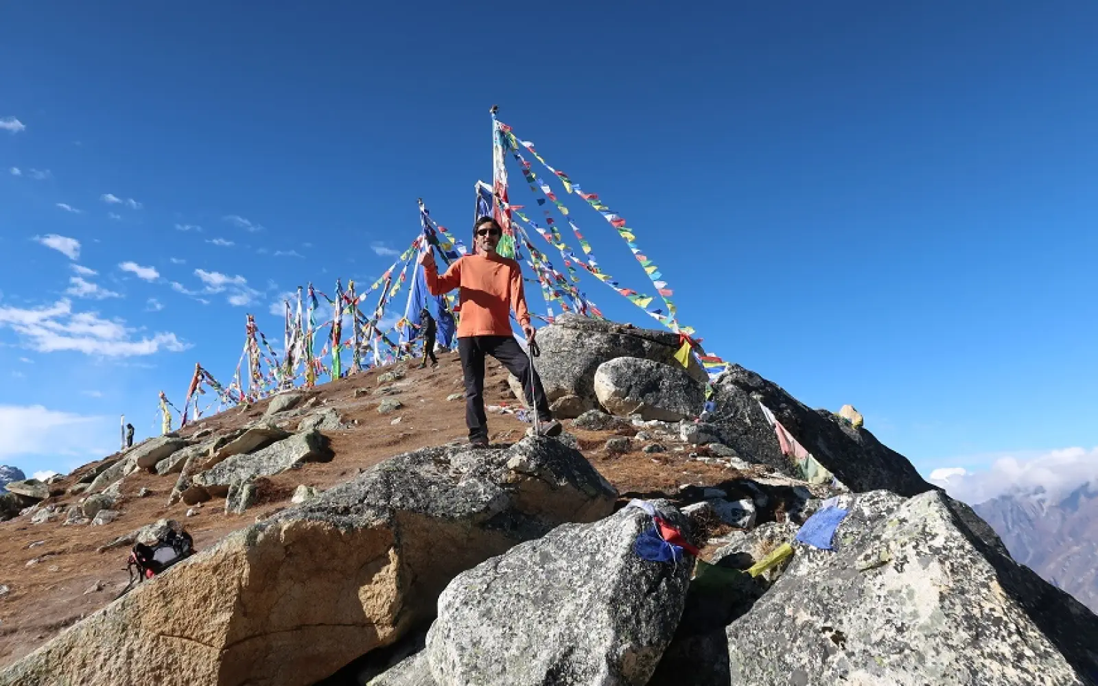
First is Kyanjin Ri, the most accessible viewpoint above Kyanjin Gompa, which stands at a height of 4,773m. The trail ascends upward gradually over yak pastures and rocky ridges. Most hikers complete the round trip within five hours.
Therefore, Kyanjin Ri is fit for acclimatization as well as for sunrise photography. Trekkers can have very close up views of Langtang Lirung (7,227m) and Langshisa Ri (6,427m). The summit offers various options of safe descent on the same route.
Meanwhile, Tserko Ri-4,984m, offers the highest day hike in the Langtang Valley. The climb demands endurance as the gradient is really steep and the air is thin. However, this is compensated for by the panoramic view of glaciers and mountains.
Consequently, Tserko Ri offers wider Himalayan vistas than Kyanjin Ri. In sight are Yala Peak at 5,520m, Naya Kanga at 5,844m, and Dorje Lakpa at 6,966m. Visibility is best during clear mornings.
Here, these hikes also build altitude adaptation for longer Himalayan treks. The gain from Kyanjin Gompa at 3,870 meters is nearly 1,100 meters. The controlled ascent helps in improving the efficiency of oxygen.
Also, trail conditions remain manageable with proper footwear and pacing. Both routes stay free from technical climbing sections. Trekking poles can be useful to assist balance over loose scree.
However, the weather assessment remains necessary before attempting Tserko Ri 4,984 m. Afternoon winds are stronger near the summit. Early starts ensure safer descents.
Besides that, costs remain at a minimum since no extra permits apply. Guides charge normal trekking day rates. The usual scenario is that porters are not needed for these hikes.
More Importantly, these peaks define the Langtang Valley Trek experience; they deliver iconic imagery often used in promotional packages, and many trekkers consider them itinerary highlights.
Finally, doing the two hikes together maximizes the scenic and acclimatization benefits of Kyanjin Ri; building confidence before attempting the more challenging views from Tserko Ri completes the Langtang Valley trekking story.
Best time to hike Kyanjin Ri & Tserko Ri
Learn when it is best to ascend Kyanjin Ri, Tserko Ri, with proper climatic conditions and during good times to trek into the valley based on recommendations.
Comparison of Seasons:
Spring (Mar–May): Blooms, temperate climates, distinct
Autumn (September – November): Visibility is good, and trails are dry.
Summer (Jun-Aug): Heavy vegetation, clouds, increased danger.
Winter Season (Dec–Feb): Snow, inaccessibility.
To begin with, time remains a major factor for hiking Kyanjin Ri with a height of 4,773m and Tserko Ri with a height of 4,984m. The two mountains tower above Kyanjin Gompa, which is at a height of 3,870m in the valley of Langtang.
As a result, spring is among the most suitable times of the year to go on such treks. The months of March to May have a suitable climate with rhododendron forests in bloom below Kyanjin Gompa at an altitude of 3,870m. The clearer mornings provide views of Mount Langtang Lirung.
Further, snow in spring starts melting in higher trails, resulting in improved pathways. Chances of encountering animals in Langtang National Park are higher. The warmest time of the day remains suitable for trekking in higher regions.
However, September to November is when autumn offers the most favorable hiking environments in the Langtang Valley. During this time, hikers can expect a cool atmosphere and a cloudless sky. Mountain views will be excellent all day long.
Therefore, autumn is ideal for photographers and beginners taking high altitude treks. The trails are quick to dry up after monsoons. The winds on ridges are less fierce.
Monsoons during summer, from June to August, are a reality in this region. Landslide chances are higher with high rainfall beneath Lama Hotel, which is at an altitude of 2,470m. Internet access can be very weak during your stay at Lama Hotel.
Furthermore, leeches and slippery rocks exist in lower portions of the forests. Also, fewer trekkers mean less noise in trails. Experienced trekkers make early morning climbs.
Moreover, in winter, isolation and privacy is the best thing to experience but trekking in this time can be a challenge. The months of December, January, and February have snow beyond Kyanjin Gompa up to 3,870 meters. Therefore, it is not suggested to go for Kyanjin Gompa and Tserko ri hiking during winter season.
As a consequence, micro-spikes and weather forecasts are necessary for hikers during the winter season. The days are short with early sunsets. Sky clearance can sometimes reward trekkers.
In conclusion, spring and autumn offer the best combination of safety and sight for Kyanjin and Tserko ri day hikes. Such seasons allow a higher rate of both summit successes. Most trekking packages in the Langtang Valley organize climbing during these times.
Level of Difficulty of Tserko and Kyanjin ri Hikes
Learn Kyanjin Ri & Tserko Ri difficulty, altitude gain, fitness level, & requirements for safe day hikes in the Langtang Valley.
To begin with, Kyanjin Ri (4,773m) is of moderate difficulty. One begins hiking right from Kyanjin Gompa (3,870m). Therefore, most trekkers take five hours to complete Kyanjin Ri. Additionally, the trekking path involves ridges and slopes with grass. Technical climbing is no longer a skill that is required.
Moreover, altitude acquired remains feasible at a speed of 900 meters. Breathing difficulties are experienced by trekkers towards the peak. Staying hydrated prevents altitude sickness.
Meanwhile, Tserko Ri (4,984m) is a rather tough high altitude trek. The climb is steeper with more miles to walk. Thin air leads to exhaustion above 4,500 meters.
Therefore, trekkers need excellent cardiovascular health for Tserko Ri. Climbs can last over six hours round trip. Exposure to the elements is common when approaching the summit ridge.
Nevertheless, this trail remains non-technical with rugged elements. Scree slopes have loose rocks. Hikers need to be extra careful. Trekking poles help in balance.
Likewise, pre-existing acclimatization is an important factor in both hikes. Trekkers will have two nights at Kyanjin Gompa at 3,870 meters. Gradual exposure prevents AMS.
Additionally, guided support provides safety and pacing advantages. They are in charge of clients’ symptoms and any weather changes. The cost is affordable in packages offered for a trek in the Langtang Valley.
Importantly, difficulty level varies with fitness and altitude exposure. Kyanjin Ri is ideal for beginners with acclimatization. Tserko Ri is a treat for seasoned trekkers.
Lastly, both treks complement each other in a perfect way. Kyanjin Ri gives you confidence before embarking on Tserko Ri. They both make up the Langtang Valley trekking experience.
Preparing for Your Day Hike: Fitness & Acclimatization Tips
Get ready for Kyanjin Ri and Tserko Ri day hikes with tested fitness training, acclimatization strategies, and safe altitude practices.
Key Tips to Prepare
Cardiovascular endurance training before Langtang Valley Trek
Acclimatization in Kyanjin Gompa (3,870m) for two nights
High Altitude Day Hike Hydrating Strategy
Acclimatization to AMS for Kyanjin Ri, 4,773m, Tserko Ri, 4,984m
Affordable guide support for safer trekking
First and foremost, success on Kyanjin Ri at 4,773m and Tserko Ri at 4,984m requires proper preparation. A few hours' day hikes for both the peaks originate from Kyanjin Gompa, which lies in the Langtang Valley at an altitude of 3,870m. Fitness and acclimatization directly affect safety and enjoyment.
It is therefore wise to start cardiovascular training several weeks before embarking on the Langtang Valley Trek. Hiking, cycling, and climbing stairs enhance endurance levels. When the lungs and legs are strong, fatigue at altitude becomes less.
Secondly, leg strength will support long uphill sections above Kyanjin Gompa (3,870m). Squats and lunges prepare muscles for steep gradients. Core stability improves balance on rocky terrain.
While acclimatization means the gradual altitude exposition during the trek: a couple of nights usually are spent at Kyanjin Gompa (3,870m); this allows for natural adaptation to be achieved by the body.
Consequently, hydration is most important at high altitude. Dry mountain air increases fluid loss. It is important to drink three to four liters a day to support acclimatization.
Besides, slow pace prevents AMS in an ascent. Trekkers must feel conversational breathing. Rest stops regulate heart rates.
Additionally, nutrition aids in energy levels on day hikes. Carbohydrate-laden meals increase endurance at altitude. Warm soups nourish through digestion and hydration.
However, it is still important to recognize the symptoms of altitude. Headache, nausea, and dizziness are symptoms that indicate rest is necessary. Most symptoms of mild cases are resolved by immediate descent.
Importantly, guided support improves safety and decision-making. Guides monitor physical condition and changes in the weather. Daily guide costs average USD 25-35.
In the end, it is balanced fitness and acclimatization that guarantee successful summit attempts. Prepared trekkers have not only much safer ascents but also clearer views. These strategies maximize the Langtang Valley hiking experience.
The trail from Kyanjin Gompa to the Viewpoints:
Get an overview of the Kyanjin Gompa to Kyanjin Ri and Tserko Ri trail, with route information, elevation gain, and the best vistas.
Feature
Kyanjin Ri (4,773m) | Tserko Ri (4,984m)
Starting Point
Kyanjin Gompa (3,870m) | Kyanjin Gompa (3,870m)
Trail Type
Gradual ridge | Steep alpine slope
Key Views
Langtang Lirung (7,227m) | Dolje Lakpa (6,966m)
Difficulty
Moderate | Challenging
Average Time
4–5 hours | 6–7 hours
Basically, all viewpoint hikes start from Kyanjin Gompa (3,870m), which is the last settlement in the Langtang Valley. The village lies beneath glaciers and alpine ridges. Trails branch clearly toward Kyanjin Ri and Tserko Ri.
Therefore, the Kyanjin Ri (4,773m) trail starts east of the monastery. The path goes up grassy slopes and stone steps. Gradual elevation gain supports acclimatization.
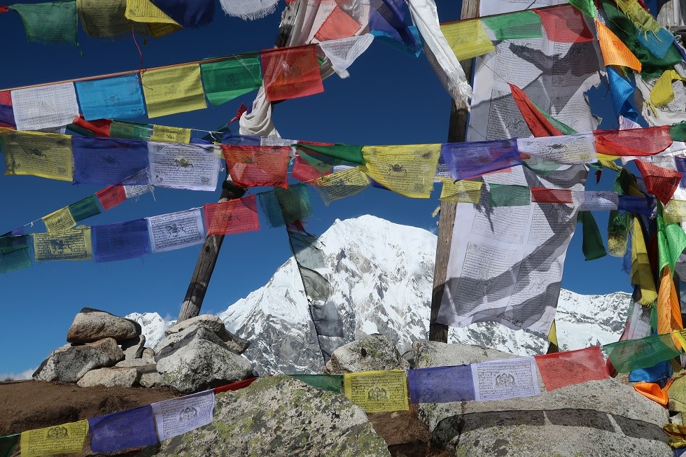
Besides, trekkers get stunning views of Langtang Lirung 7,227m while ascending. Rest points on the ridge are marked by prayer flags. The summit reveals views of the valleys in all directions.
Meanwhile, the trail to Tserko Ri (4,984m) starts north of Kyanjin Gompa (3,870m). The trail is along yak pasture and glacial moraines. Above 4,500 meters, steeper sections appear.
Consequently, both trails remain non-technical but physically demanding. Scrambling over loose rocks demands careful footing. Trekking poles enhance stability.
Besides that, meteorological conditions are prone to sudden changes of weather around the viewpoints. Early morning starts ensure less wind exposure, whereas clear skies provide better visibility of the mountains.
Moreover, the descent also follows the same routes back to Kyanjin Gompa 3,870m. Knees get badly hurt in case of improper pace on downhill sections. Controlled steps avert injuries.
Importantly, landmarks give navigation without confusion. The stone cairns and worn paths guide the hikers to their correct trails. Guides ensure the correct choice of route on snow.
These, finally, are the trails that define the Langtang Valley Trek experience: a mix of accessibility with dramatic Himalayan scenery. Meaningful viewpoints complete the hikes and make the journey come full circle in meaning.
Compare Kyanjin Ri and Tserko Ri routes based on elevation gain, distance, difficulty, scenery, and suitability for Langtang Valley trekkers.
Route Comparison:
Factor
Kyanjin Ri (4,773m) | Tserko Ri (4,984m)
Distance
Shorter | Longer
Elevation Gain
Moderate | High
Difficulty
Easy-to-Moderate | Challenging
Best Use
Acclimatization | Panoramic summit
Actually, both routes start from Kyanjin Gompa, at 3,870m, the alpine hub of the Langtang Valley Trek. Each trail delivers panoramic Himalayan viewpoints within a single day. However, route character and effort differ significantly.
In fact, the Kyanjin Ri route, therefore, focuses on a gradually increasing altitude gain with a shorter distance of 4,773m. The trail follows grassy slopes and a defined ridge east of the monastery. Through this steady elevation gain, hikers build their confidence.
Moreover, Kyanjin Ri suits acclimatization days during the Langtang Valley Trek. The route allows frequent pauses and easy turnaround options. Clear views of Langtang Lirung (7,227m) dominate the skyline.
While the latter, Tserko Ri (4,984m) requires much more time and endurance. The trail proceeds north across yak pastures and glacial moraines; steep gradients appear above 4,500 meters.
Accordingly, Tserko Ri offers a persistence reward with broader Himalayan vistas. Peaks include Dorje Lakpa (6,966m), Langshisa Ri (6,427m), and Yala Peak (5,520m). The summit offers a 360-degree panorama.
Moreover, the exposure on the trail is different in both routes. Kyanjin Ri remains partially protected by ridges. Tserko Ri has stronger winds closer to the summit.
Here, route marking also favors Kyanjin Ri. Tserko Ri demands attention in snowy conditions. Guides make both trails much safer.
Time management, however, separates these hikes clearly: Kyanjin Ri averages five hours round trip; Tserko Ri often requires seven hours.
Importantly, costs remain similar since no extra permits apply. Standard guide fees range between USD 25 and 35. Equipment needs remain basic for both hikes.
Ultimately, the choice of route does depend on fitness, weather, and acclimatization. Kyanjin Ri does build readiness efficiently. Tserko Ri completes the Langtang Valley experience.
Kyanjin Ri Trek: How to Do It?
Follow a step-by-step guide to hiking Kyanjin Ri with route stages, time factor, elevation gain, and safety tips starting from Kyanjin Gompa.
Summary Steps:
Start early from Kyanjin Gompa (3,870m)
Follow eastern ridge trail to Kyanjin Ri (4,773m)
Do not rush-keep a slow pace to acclimatize.
Summit views of Langtang Lirung (7,227m)
Descend safely before afternoon winds
Start early from Kyanjin Gompa (3,870m) in order to gain clear weather windows. It is less windy when the morning starts, and cloud build-up is minimal. A light breakfast for steady energy.
Likewise, follow the eastern path behind the monastery towards open slopes. The trail rises gently across yak pastures; prayer flags show the right direction.
Besides, a slow, rhythmic gait over the initial hour is a recommendation; the gentle gradient ensures comfortable breathing; small breaks further support acclimatization.
Meanwhile, reach the mid-ridge viewpoint at about 4,300 meters. The views of Langtang Lirung at 7,227m increase tremendously. Hydration remains essential here as well.
Consequently, follow the narrowing ridge ahead to steeper sections. The trail continues to be clear but rocky. Trekking poles improve the balance.
Also, progress towards the summit ridge with controlled steps. Thin air promotes tiredness near Kyanjin Ri (4,773 m). Focus on your breathing rhythm.
Moreover, reach the top and have some rest. You can see panoramas of Dorje Lakpa (6,966m) and Langshisa Ri (6,427m). Photography time should not be longer since you feel cold.
However, be sure to descend early in order to beat the afternoon weather changes. Downhill parts are rough on knees if not taken at a good pace. Poles should be used consistently.
Importantly, return to Kyanjin Gompa (3,870m) along the same route. Warm fluids aid recovery. Light stretching reduces soreness.
Finally, this structured approach ensures safety and enjoyment. Kyanjin Ri does build altitude confidence effectively. The hike completes a key Langtang Valley highlight.
Hiking Tserko Ri-Step by Step
Follow a full step-by-step guide to hiking Tserko Ri with route stages, timing, altitude gain, safety tips, and Langtang Valley views.
Overview of Steps:
Start early from Kyanjin Gompa, 3,870m.
Gradual ascent across yak pastures
Steeper climb above 4,400m
Trek to Summit at Tserko Ri (4,984m)
Descent on the same route for safety
Start early from Kyanjin Gompa (3,870m), while much of the day's weather is still stable. Early departures reduce wind exposure and cloud buildup. A warm breakfast supports sustained energy.
Follow the northern trail leaving Kyanjin Gompa at 3,870 meters across open yak pastures. The path climbs easily during the first hour. This section helps warm the muscles up gradually.
Besides, walk slowly and steadily to let acclimatization take place. Controlled breathing at altitude saves energy. Frequent short rests ward off early exhaustion.
Meanwhile, get to the mid-slope zone at about 4,400 meters where the gradients increase. The terrain then changes into rocky alpine ground. It is here that trekking poles improve one's balance.
Consequently, from here on, make your way up very carefully since the levels of oxygen are strikingly dropped. The trail is visible but steeper. Mental focus becomes important above this point.
Besides, have a gentle, well-structured approach towards the last ridge. Generally, there are strong winds close to Tserko Ri (4,984m). Put on clothes in layers to guard against cold suddenly.
Further, go to the top and take a few minutes to rest. The views include Langtang Lirung (7,227m), Dorje Lakpa (6,966m), Langshisa Ri (6,427m), and Yala Peak (5,520 m). Photography should not take any longer because of wind chill.
However, start your descent early to avoid meteorological changes in the afternoon. Slow descent avoids shocking knees and ankles. There is a need for careful placement of feet since the way down contains loose stones.
Importantly, return to Kyanjin Gompa (3,870m) along the same route. Warm drinks assist recovery after exertion. Light stretching reduces muscle stiffness.
Finally, this structured ascent ensures safety and success. Tserko Ri is considered the highest viewpoint on the Langtang Valley Trek. Proper pacing transforms challenge into achievement.
What to Pack for a Day Hike in High Altitude
Below is a discussion on what to pack for high-altitude day hikes, including essentials in clothing, gear, safety, and packing tips for Langtang Valley trails.
Essential Things to Pack
Insulated jacket and waterproof shell
Trekking boots and warm socks
Trekking poles and gloves
Water bottles and energy snacks
Sunglasses, sunscreen, hat
First-aid kit and headlamp
These essentials ensure safe and enjoyable high-altitude day hikes in Langtang Valley.
First of all, proper packing means comfort and safety during any high-altitude day hike. For example, Kyanjin Ri (4,773m) and Tserko Ri (4,984m) expose trekkers to sudden and fast weather changes. Lightweight and functional gear remains important.
Hence, layered clothing comprises the base of your packing list. A temperature-regulating base layer made of moisture-wicking material gets you started. Insulating layers trap warmth very well.
Besides, it is an outer shell that windproofs or waterproofs against cold gusts. The weather above Kyanjin Gompa, 3,870m, changes pretty fast. It's quality jackets that will prevent heat loss.
Meanwhile, footwear plays an important role in trail safety: sturdy trekking boots provide ankle support on rocky paths, while wool socks reduce the risk of blistering.
Consequently, balance improves and knee strain becomes much less extreme, which is made better by using trekking poles. Steep descents require joint support. At altitude, poles also improve rhythm.
More importantly, hydration equipment is not optional. Bring a minimum of two liters of water. Insulated bottles do not freeze in cold conditions.
In addition, nutrition favors energy output. Pack high-carbohydrate snacks like energy bars and dried fruits. Warm drinks raise comfort.
However, sun protection is often forgotten at altitude. UV exposure increases dramatically above 4,000 meters. Sunglasses and sunscreen prevent injury.
Safety items importantly provide reassurance on exposed routes. A basic first-aid kit handles minor issues. Headlamps support early starts and late returns.
Finally, pack light but smart to create efficiency. A small daypack works best-between 20-30 liters. Balanced packing improves hiking performance.
Preventing Altitude Sickness on Day Hikes
Explore the different ways to prevent altitude sickness in the high-altitude day hike through the Langtang Valley, including acclimatization, speed, hydration, and safety concerns.
Key Prevention Measures:
Acclimatization at Kyanjin Gompa for two nights (3,870m)
Slow ascent to Kyanjin Ri (4,773m) and Tserko Ri (4,984m)
High hydration and carbohydrate intake
Early recognition of symptoms, early descent
Supported monitoring
Actually, it is highly recommended that, during day hikes above Kyanjin Gompa, which is at an altitude of 3,870m, precautions against altitude sickness be considered. When someone is out of their comfort zone, their body is affected fast when oxygen is low. Therefore, being well-informed about it is a protection for trekkers on Kyanjin Ri, 4,773m, and Tserko Ri, 4,984m.
Therefore, the main protection against AMS is represented by the principle of gradual acclimatization. The trekkers must spend at least two nights at Kyanjin Gompa-3,870m to gain time for physiological adjustment.
In addition, slow pacing during ascent reduces the stress on the respiratory system. Throughout the climb, hikers should breathe conversationally. Heart rate is stabilized with frequent short breaks.
At the same time, hydration directly contributes to altitude adaptation. The dry alpine air contributes to quick dehydration. Drinking three to four liters a day can improve oxygen circulation.
Hence, nutrition also acts as a key factor in altitude tolerance. Carbohydrate-rich foods produce effective energy at altitude. Light, frequent snacks help avoid exhaustion.
Here, the other factor that affects the process of acclimatization is adequate sleep. Rest days are helpful in improving oxygen saturation naturally. Avoid exhausting yourself before attempting summits.
Besides, noticing the symptoms in time makes people respond to them in good time. Headache, nausea, and dizziness are symptoms of mild Acute Mountain Sickness, and rest must be taken immediately to prevent further aggravation.
But ignoring symptoms increases risk in a hurry. Further ascent worsens the condition. Descent is still the best treatment.
Importantly, acclimatization is impaired by alcohol and smoking. Both reduce the efficiency of oxygen absorption. Avoid both before high-altitude hikes.
Meanwhile, medicines such as acetazolamide may help some trekkers. Consult your doctor. It is important to remember that medications are never a substitute for acclimatization.
In addition, guided trekking enhances altitude safety. The guides will monitor the physical condition and pacing. The daily cost of a guide ranges between USD 25 and USD 35.
Ultimately, safe and enjoyable day hikes require informed preparation. Altitude awareness changes risk into manageable challenge. Prevention strategies define successful Langtang Valley trekking.
Sunrise Hikes: Catch the Golden Hour at the Summit
Enjoy sunrise hikes in Langtang Valley and golden-hour views from Kyanjin Ri and Tserko Ri under clear Himalayan skies.
Essentials for Sunrise Hiking:
Early start from Kyanjin Gompa (3,870m)
Headlamp and warm layers
Target Kyanjin Ri (4,773m), or Tserko Ri (4,984m),
Clear views of Langtang Lirung (7,227m)
Guided timing for safety and success
Actually, sunrise hikes are the most rewarding experiences in the Langtang Valley. Early light transforms snow peaks into golden landscapes. Calm morning weather enhances safety.
Thus, Kyanjin Ri-4,773m is the most popular sunrise viewpoint because its shorter route allows for pre-dawn ascents from Kyanjin Gompa-3,870m. Trekkers often start around 4:30 AM.
Then, sunrise brings out the dramatic colors across Langtang Lirung-7,227m. Shadows and light create exceptional depth. Photographers prefer this timing.
Meanwhile, sunrise hikes to Tserko Ri (4,984m) require stronger fitness. It is necessary to make earlier starts because of the longer distance. Headlamps will light the initial ascent.
Here, the prize involves panoramic Himalayan illumination. Peaks such as Dorje Lakpa view at 6,966 above sea level and Langshisa Ri at 6,427 above sea level shine bright. Wind conditions stay pretty calm during dawn.
Besides that, before daybreak, the temperatures are very low. Proper layering certainly ensures comfort at rest stops. Gloves and hats become insulated gloves and hats.
Besides, early starts reduce afternoon cloud interference. The best visibility in the first two hours. Weather stability improves summit success.
Timing, however, is usually crucial. It depends on how well a trekker can plan his or her time of ascent, for which guides are available to help the trekkers regarding the schedules of departure.
Importantly, safety remains critical during low-light conditions. Headlamps with spare batteries ensure visibility, while trekking poles improve balance on rocky paths.
Meanwhile, decent happens after sunrise warmth returns. Softer light improves depth perception. Descending in daylight reduces risk.
Further, sunrise hikes boost itinerary efficiency. Trekkers return early for rest and meals, which helps support longer treks because the energy is conserved.
Ultimately, the golden hour at summits defines Langtang Valley memories. Sunrise hikes combine beauty, clarity, and tranquility. They are the highlight of day hiking at high altitude.
Panoramic views you will see from the peaks
Enjoy panoramic Himalayan views from Kyanjin Ri and Tserko Ri, featuring glaciers, valleys, and iconic peaks in Langtang Valley.
Key Panoramic Highlights:
Langtang Lirung-7,227m-dominating the eastern skyline
Dorje Lakpa visible from Tserko Ri (6,966-4,984m)
Langtang Glacier from both peaks
Kyanjin Gompa (3,870m) valley view
Yala Peak 5,520m Alpine Prominence
Meanwhile, the panorama from the peaks of Langtang Valley is the ultimate reward for day hikes at high altitude. Kyanjin Ri at 4,773 meters and Tserko Ri at 4,984 meters above sea level tower over Kyanjin Gompa at 3,870 meters. Their summits assure the onslaught of uninterrupted Himalayan horizons.
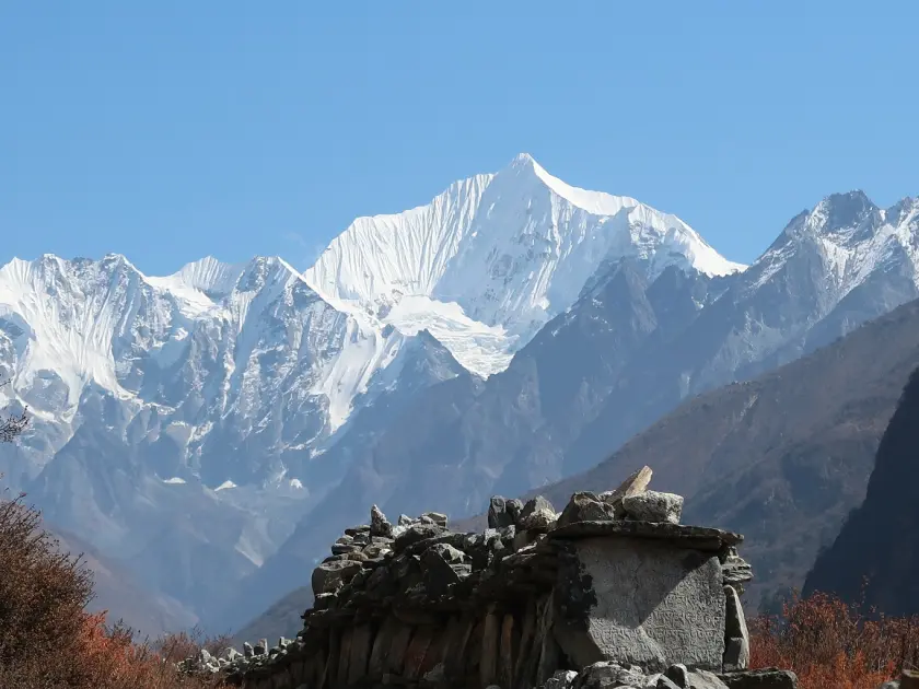
Therefore, Kyanjin Ri-4,773m offers extensive views for minimum technical effort. The summit overlooks the entire Langtang Valley corridor. Glacial valleys fall dramatically below.
Besides, from Kyanjin Ri, Langtang Lirung (7,227m) fills the eastern skyline. Its immense ice faces seem to be so close. Morning light improves texture and depth.
Meanwhile, Langshisa Ri (6,427m) and Gang Chhenpo (6,388m) appear clearly from both viewpoints. The snow ridges of those peaks create striking contrasts against deep blue skies. Visibility improves during the early hours.
Thus, Tserko Ri at 4,984m offers broader and higher panoramic coverage. The vantage point offers a near complete 360-degree circle of Himalaya. Glaciers and ridgelines extend endlessly.
Additionally, Dorje Lakpa rises pyramid-like toward the southeast. Its pyramid face creates stunning compositions. Its sharp profile comes prominently into view during clear autumn mornings.
Moreover, Yala Peak itself-5,520m-seems nearby and clearly different from Tserko Ri. It has been observed that trekkers generally visually identify a climbing route. The peak gives the panorama an adventure character.
However, from up above, the valley floor too commands attention. Kyanjin Gompa at 3,870m looks miniature among moraines and rivers; yak pastures form a number of geometrical patterns.
More importantly, it is from the higher ridges that the Langtang Glacier becomes full in your vision. The ice flow and crevasses create dynamic natural imagery. Seasonal snow is ever-changing in appearance.
Meanwhile, western views include far-off Tibetan plateau landscapes: rolling highlands contrasting with sharp Himalayan peaks; atmospheric clarity enhances depth perception.
Besides that, the light conditions change the aspect of landscapes at any time of the day: sunrise colors the snowfields with warm golden tones, and at noon, it enhances clarity and contrast.
Moreover, moving clouds add drama but do not completely block the peaks. Slow-moving clouds create layering in compositions. Wind patterns are visible from above.
Ultimately, it is panoramic views that define the emotional high point of hikes in Langtang Valley. These summits are visual rewards commensurate with major trekking routes. Every direction offers Himalayan grandeur.
Essential photography tips for Himalayan day hikes in regards to light, composition and gear, plus the additional altitude challenge that will be faced in the Langtang Valley.
Essential Photography Tips:
Shoot during the early golden hour:
Protect batteries from cold
Use wide-angle lenses for scale
Include foreground elements
Prioritize safety at altitude
First of all, the Himalayas need preparation different from ordinary landscape photography. The high altitude and strong light make their mark in terms of exposure in a very short time. Strategic planning ensures quality images.
Early starts are, therefore, not avoidable if photographers are to be successful in their craft. Sunrise light provides soft tones with long shadows. Light winds improve the sharpness of images.
Furthermore, Kyanjin Ri offers ideal sunrise angles at an elevation of 4,773 meters. Langtang Lirung becomes dramatically touched by the first light at an altitude of 7,227 meters. Consequently, the snow textures become highly visible.
Simultaneously, Tserko Ri-4,984m is offering extensive compositions requiring wide-angle lenses. The broad valleys and glaciers fit best with the wide focal length. Panoramas work exceptionally good.
Thus, camera settings have to be controlled manually at altitude; bright snow confuses automatic metering and slight underexposure preserves detail.
Moreover, lens selection creates different storytelling effects. Wide lenses portray scale well. The telephoto lenses isolate peaks that may be distant, like Dorje Lakpa at 6,966m.
Besides, stabilization is still key on windy ridges. Light tripods create better sunrise shootings. Trekking poles can serve as supports.
However, in cold conditions, performance falls dramatically. Spare batteries should be kept insulated. Warm pockets prolong the life of batteries.
Importantly, composition improves by including foreground elements: it adds depth to a prayer flag, rocks, or trails that may lead the viewer's attention.
In fact, human elements throughout meanwhile enhance scale perception. Small figures against massive peaks emphasize magnitude. This technique strengthens storytelling.
Furthermore, photographic decisions must be guided by issues of safety. Avoid risky positioning near ridges or heights. No image is worth personal safety.
Consequently, the less the gear, the better mobility at altitude. A light, mirrorless camera suits day hikes. Heavy equipment increases fatigue.
Meanwhile, editing considerations begin during capture: balanced white settings simplify post-processing, while RAW format preserves dynamic range.
Besides that, responsible photography respects local culture. Respect private areas near monasteries; ask for permission to take portraits.
After all, Himalayan photography asks for nothing but your patience and self-discipline. The preparation always turns those transient moments into lifetime views. Langtang Valley-an enchanting valley, full of creative possibilities.
Local Culture at Kyanzin Gompa
Learn culture in Kyanjin Gompa with a focus on Tibetan culture, Buddhism, monasteries, yak herding in this mountainous region of the Langtang Valley.
Cultural Highlights:
Kyanjin Gompa Monastery
Traditions of yak herding
Tibetan Buddhist rituals – prayers,
Production of local cheese
To begin with, Kyanjin Gompa (3,870m) is considered to be the cultural hub of the upper part of the valley. The culture of this village shows how this region has been under the influence of Tibetan Buddhism for a very long time.
As a result, Tibetan descent communities have influenced local culture greatly. Locals follow Mahayana Buddhism deeply. Prayer flags, mani walls, and chortens can be seen everywhere.
In addition, Kyanjin Gompa Monastery (3,870m) acts as a religious lifeline in this area. Every day, monks conduct rituals inside a prayer hall. The sound of bells, prayers, and incense characterize this setting.
Meanwhile, local architecture shows acumen in coping with harsh alpine climatic conditions. Houses constructed using stone have flat roofs and thick walls. Such buildings can conserve heat very effectively.
Therefore, yak herding is an important livelihood activity. The yaks offer milk, butter, meat, and transport. The grazing habits are based on altitude.
Additionally, a famous yak cheese factory in Kyanjin Gompa, which is at an altitude of 3,870 meters, provides support in terms of sustainable income. The people make cheese in a traditional way.
Moreover, hospitality is a very important role in culture. The owners of teahouses greet trekkers warmly. Shared food space promotes interaction. Monasteries call for restraint in behavior. Taking pictures in religious sites requires prior permission.
Importantly, festivals showcase cultural identity. The Lhosar Festival is an event that celebrates the Tibetan New Year. The festival brings people from villages to pray and share food.
On the other hand, religious beliefs influence mountain veneration. They see mountains, including Langtang Lirung (7,227m) peak, as religious sites.
Likewise, traditional clothes can be seen during rituals. Wool clothes provide protection from cold climates. Jewelry shows lineage.
Moreover, storytelling in an oral form saves history. Seniors share migration stories and avalanche stories. Such stories bring people together.
Therefore, modernization affects life incrementally. Solar energy and mobile technology become evident. Anyway, culture persists strongly.
On the other hand, Tourism brings in a stable source of income. Teahouse treks can boost education and healthcare systems. Sensible trekking promotes cultural
Further, expenses for cultural interaction are very low. Contributions to monasteries are voluntary. Small expenditures in local businesses improve sustainability.
Actually, Kyanjin Gompa culture is very enriching in making a Langtang Valley Trek an unforgettable experience. Spiritual depth adds to mountain beauty. Immersion in culture leaves lifetime impressions.
Wildlife and Flora you May Encounter
Learn about the flora and fauna in the Langtang Valley, including red panda habitats, Himalayan birds, flowers, and biodiversity sanctuaries.
Wildlife and Flora Highlights:
Red panda habitat
Himalayan Tahr sightings
Alpine Rhodod
Himalayan Monal
Bird Conserved: Langtang National Park
To begin with, the valley is characterized by a variety of wildlife because of the different elevation levels. The valley falls within Langtang National Park. This serves to conserve the biodiversity.
Hence, the forest regions below Kyanjin Gompa (3,870m) have dense vegetation. Rhododendron, oak, and pine are mainly found in lower slopes. Scenic flowers
Furthermore, above the level of trees, alpine meadows have specialized vegetation. Edelweiss and dwarf plants thrive in cold environments. A short growing season characterizes vegetation.
Meanwhile, encounters with wild animals are common during less busy hours in the early morning. Himalayan tahr are seen grazing in steep slopes. Their agility leaves people in awe.
Therefore, the mysterious red panda lives in forested areas below 3,500 meters. Approval in these regions can be considered a bamboo-positive diet.
Moreover, Himalayan langurs travel in social bunches. Their voices resonant in the forests. Trained trekkers can spot them along trails.
Likewise, a variety of birds can be found at different heights. The Himalayan monal shows colorful patterns on their bodies. Snow pigeons can be
However, major predators are hard to come by. Snow leopards are found in distant ridges in the proximity of Langtang Lirung (7,227m). Tracing
Insects greatly aid in maintaining a balance in nature. Butterflies are observed in spring. Plant pollination is aided in alpine vegetation.
Meanwhile, there is seasonality in terms of the behavior of the animals. The animals come down in winter. They become widely distributed in summer
Furthermore, conservation measures control human interaction. Entry permits assist in controlling human interaction in the park. Waste control promotes conservation by protecting habitats.
In fact, trekkers are involved in preservation. Staying on trails will help in protecting habitats. Observing without disturbing will help in preservation.
Therefore, photo shoots must conduct themselves in an ethical manner. Long lenses do not stress animals. Quietness is vital for better sightings.
Meanwhile, medicinal herbs can grow on their own. Citizens pick them in a controlled manner.
Similarly, climate change affects biodiversity in a slow manner. The change in seasons affects plant life. Observations are being made.
Overall, however, the Langtang Valley presents a great deal of ecological diversity. The presence of animals and vegetation adds to treks in this region.
Safety Tips & Mountain Weather Conditions
Understand important safety information and mountain weather factors to keep in mind when engaging in day treks in the Langtang Valley.
Important Safety Features:
Early starts in stable weather
Dress in layers to protect against the wind and cold
Guided support above 4,000 meters
Weather at Kyanjin Ri (4,773m)
Decisions in Tserko Ri (4,984m
To begin with, safety is always a priority in day treks in the Himalayas in the area of the Langtang Valley. Conditions above Kyanjin Gompa, which stands at 3,870 meters above sea level, make trekkers vulnerable to altitude and climatic factors.
Hence, it is necessary to have knowledge of mountain weather before embarking on a trip. Weather can fluctuate greatly in and around Kyanjin Ri, which is 4,773 meters above sea level, and in Tserko Ri, which is 4,
Furthermore, early starts improve safety margins considerably. Conditions in the early morning hours are less turbulent and more predictable. Conditions in the afternoon promote cloud buildups, which make navigation harder.
At the same time, temperature fluctuation is a problem for trekkers who are not prepared. Freezing winds follow warm sunshine. Layers of clothes regulate body temperatures.
Therefore, wind chill is a serious hazard in exposed ridges. Strong gusts are common in Tserko Ri, which stands at 4,984m. Insulated jackets and gloves are necessary to avoid hypothermia.
Moreover, snow can fall during other months as well. Fresh snow covers trail signs. Guides help in identifying trails.
Here, hill dangers demand eternal vigilance. Rolled up rocks make it slippery on sloping grounds. Trekking poles help in maintaining balance.
However, altitude dangers add to the difficulties presented by weather. Hypoxia impairs judgment and bodily coordination. Pacing remains slow.
Importantly, trekkers need to observe their personal physiological state all along. Patients with headaches and dizziness must immediately take a complete rest.
Further, knowing the routes can improve confidence and safety. Map knowledge of trails can aid in orientation. Furthermore, local guidance can offer up-to-date information.
Moreover, communication readiness is helpful during emergencies. Mobile phone signals are unreliable above Kyanjin Gompa (3,870m). Notification of the plans to the lodges is an added safety precaution
Similarly, daylight management affects safety. Short days during winter constrain hiking time. Headlights will provide illumination in case of postponement.
Therefore, group travel enhances risk management. Friends assist in case of fatigue. Alone hiking is risky.
On the other hand, encounters with wild animals are less common but can be feasible. Keeping a safe distance is a way to avoid stressing them. Being non-confrontational
Furthermore, investment in safety upgradation remains affordable. The cost of a guide, for instance, will amount to USD 25 to 35 per day. Improvement in decision-making takes place with investment.
Further, a local warning can improve safety results. Tea house owners have good knowledge of local weather. Their advice can be trusted.
At last, safety awareness converts mountain uncertainty into manageable challenge. Well-prepared trekkers make confident climbs. Weather respect is the key to successful Langtang Valley treks.
Hydration & Nutrition on the Trail
Learn hydration and nutrition tips for high altitude day hiking in the Langtang Valley for maintaining energy, health, and performance.
Hydration & Nutrition Needs:
Warm carbohydrate-rich foods
Electrolyte balance at altitude
Light Snacks during Ascent
As Insulated Bottles for Cold Weather
Firstly, hydration is an important factor during high altitude trekking. The less humid climate increases fluid evaporation above Kyanjin Gompa (3,870m). Dehydration aggravates altitude sickness. Thus, trekkers are advised to drink all along when trekking. Drinking when thirsty in high altituedues not work.
Furthermore, water demand rises during climbing. Cold environments make it difficult to notice dehydration symptoms. Daily consumption of three to four liters is adequate for performance.
Meanwhile, water resources have to be treated in order to be safe. Boiled water is common in teahouses. Water Purification tablets are an alternative.
Therefore, maintaining electrolyte balance promotes muscular function. Electrolyte solutions replenish lost minerals in the body from sweating. Warm beverages aid in absorption.
Further, nutrition provides sustained energy on steep slopes. At high altitude, carbohydrates can be easily converted to energy. Rice, potatoes, and bread are recommended.
Moreover, quality in breakfast can affect summit attains. Hot food gives sustained energy. Breakfast skipped hinders endurance.
However, high foods slow digestion in high places. Small portions promote easy digestion. Snacking ensures sugar levels in the blood.
Importantly, proteins help in muscle recovery after activities. Lentils and eggs are some of the most common sources of this food. Well-balanced food improves endurance.
Fats, on the other hand, function as a prolonged source of energy in cold climates. Butter Tea is a source of both warmth and energy. A reduced appetite can also be a factor at higher altitudes. While eating in a survival situation is important in order not to exhaust one’s energy sources
Moreover, in relation to organizational performance, correct nutrition timing enhances output. Snacking before becoming tired promotes conservation of strength. Snack breaks timed according to schedule are quite effective.
Therefore, hydration plans vary depending on the season. Insulated containers are used in winter. Increased fluid intake is required in summer.
On the other hand, consumption of caffeine must be in moderation. Taking too much tea leads to dehydration. Moderation enhances hydration efficiency
In fact, recommendations in a guiding tool increase nutritional planning. A guiding tool modifies pace according to an individual’s energy levels. Better results come with experience.
Furthermore, food expenses are not very high in these trails. Food will cost approximately 5 to 8 USD in and around Kyanjin Gompa, which is at an altitude of 3,870m.
Eventually, hydration and nutrition impact hiking performance greatly. They improve safety and hiking fun. Well-prepared trekkers hike in Langtang without fear.
After the Hike: Best Places to Rest in Kyanjin Gompa
Learn where to stay in Kyanjin Gompa to recover from your Kyanjin Ri and Tserko Ri hike and enjoy comfort, food, and a warm stay.
Best Places to Rest in Kyanjin Gompa:
Warm Teahouses with Heated Dining Halls
Accommodations in and around Kyanjin Gompa
Teahouses with yak cheese for nutrition recovery
Sunny outdoor benches for gentle relaxation
Affordable rooms with thick bedding
On one hand, sleeping in high altitude treks will become a necessity for acclimatization. Kyanin Gompa, which is 3,870 meters above sea level, provides resting opportunities in a relaxed manner.
As a consequence, "teahouses are today the main resting option in Kyanzin Gompa (3,870m). The majority have heated dining halls and offer warm sleeping blankets. This helps maintain a stable body temperature when resting in a
Additionally, a concentration of public teahouses is located in and around the monastery. Being in a central location lessens walks after hiking. Walking can be tiresome when hiking ends.
At the same time, dining halls act as social recovery spaces. Trekkers share experiences during warming-up sessions. Hot beverages promote circulation and relaxation.
Therefore, yak cheese teahouses have a nutritional recovery function. High-quality proteins in cheese help heal muscles. Local foods improve digestion.
Moreover, some lodges have better-insulated rooms. Insulated blankets provide better sleep at night. Sound sleep is essential for acclimatization.
Moreover, resting sites with sun exposure are also a pulling factor for trekkers during afternoon hours. Benches warmed up by the sun combat cold stress. Soft sun rays boost moods.
However, overexertion is to be avoided after hiking. Resting immediately will prevent fatigue from altitude differences. Gentle stretching will suffice.
Importantly, a serene atmosphere is offered by the monastery courtyard in the vicinity of Kyanjin Gompa, which is at 3,870 meters. Prayer flags wave gently in the breeze.
At the same time, short walks in the village help with active recovery. Exercise prevents stiffness. A flat landscape promotes blood circulation.
Moreover, some teahouses have hot showers available. Hot water is an excellent way to relax your muscles. Availability of showers depends on the weather.
Moreover, food quality determines how quickly one can recover. Foods such as warm soups and carbohydrates help to regain strength. The need for heavy food continues to be unnecessary.
Therefore, hydration does not end when the hike ends. Drinking warm beverages protects one from dehydration symptoms. Herbal teas aid in digestion.
On the other hand, resting sites with views of the mountains boost relaxation. Additionally, views of Langtang Lirung Mountain (7,227m) are available from the edges of villages.
In addition, quiet corners are ideal for meditation and respiratory exercises. Controlled respiration enhances oxygen intake.
Moreover, charges concerning resting sites are affordable. Bed and breakfast accommodations cost between USD 5 to 10 per night. Food is priced from USD 5 to 8.
Importantly, communication facilities are available in selective lodges. Wi-Fi and points for charging are important in providing mental comfort. Limited access to these two promotes sleep.
Meanwhile, nighttime is associated with lower temperatures. Evenings bring colder temperatures. Early sleep aids in warming up. Nighttime recovery gets ready for another trekking day.
Further, communal trekkers have collective space. Societal integration enhances moral standards. Emotional healing contributes to physical fitness.
Moreover, staff hospitality facilitates a resting experience. They know how to treat altitude recovery.
Therefore, eco-friendly camping leads to eco-friendly trekking. Using village accommodations cuts pressure on nature. Indirect benefit is to local economy.
Kyanjin Gompa, with an altitude of 3,870 meters, is ideal for acclimatization after the hike. Comfort, warmth, and good food all come into perfect sync. A good night’s sleep.
FAQS:
1. What is the best time to hike Kyanjin Ri and Tserko Ri? The best time to go hiking on Kyanjin Ri and Tserko Ri is in the spring from March to May and in the autumn from September to November. These are the times because the sky is clear and the weather is stable. You can see the peaks really well it is comfortable during the day and there is not much rain or snow on the trails. 2. How difficult are the Kyanjin Ri and Tserko Ri day hikes? Kyanjin Ri is a hike with some steep parts so it is okay for people who are fit and just starting out. Tserko Ri is a bit harder because it is higher up and takes longer. You need to be in shape and get used to the high altitude for both hikes but you do not need to know how to climb just walk uphill on rocky trails. 3. How can I prevent altitude sickness on Kyanjin Ri and Tserko Ri hikes? To stay safe on Kyanjin Ri and Tserko Ri hikes you need to get used to the altitude in Kyanjin Gompa go up slowly drink a lot of water do not drink alcohol and eat food with carbohydrates. You might also want to take some medicine called Diamox. You should talk to a doctor first. If you get a headache or feel sick you should go down. 4. Which is better: Kyanjin Ri or Tserko Ri? Kyanjin Ri is a choice because you can see really nice views quickly and it is not too hard. Tserko Ri is better if you want to see everything from a point but it takes more time and effort. You should choose based on how fit you're what the weather is like and how much time you have from Kyanjin Gompa. Both hikes are really nice. 5. How long does the Kyanjin Ri hike take? It usually takes 3 to 5 hours to hike up and down Kyanjin Ri from Kyanjin Gompa. The hike up is steep. Takes about 2-3 hours and the hike down takes about 1-2 hours. If you start early, you can have weather and see the sunrise. 6. How long and difficult is the Tserko Ri hike? The hike up and down Tserko Ri from Kyanjin Gompa takes 6 to 9 hours. Goes up to about 4,984 meters. It is a hike with a lot of uphill walking on rocky trails. You need to be in shape and get used to the high altitude to do this hike. 7. What should I pack for Kyanjin Ri and Tserko Ri day hikes? You should pack layers of clothes a jacket, trekking poles, sunglasses, sunscreen, a hat, gloves, water, snacks, a headlamp, a first-aid kit and a rain cover. You also need hiking boots and a backpack to be comfortable and safe on these high-altitude trails. 8. Are sunrise hikes recommended for Kyanjin Ri and Tserko Ri? Yes, it is an idea to hike up Kyanjin Ri and Tserko Ri early in the morning to see the sunrise. The light is really nice on the mountains. It is a special experience. You should leave Kyanjin Gompa before it gets light and bring a headlamp. 9. What panoramic views can I see from Kyanjin Ri and Tserko Ri? From Kyanjin Ri and Tserko Ri you can see really nice views of Langtang Lirung, Gangchenpo, Yubra and the Tibetan mountains. Tserko Ri has nicer views because it is higher up. On days you can see big mountains, glaciers and valleys which makes these hikes really special. 10. What fitness and acclimatization tips are needed for these hikes? You should spend least one night in Kyanjin Gompa to get used to the high altitude. You should also be in shape by exercising before you go. Hike slowly drink water eat well and be careful. You should talk to a doctor before you go on these high-altitude hikes. 11. What wildlife and flora might I encounter on these hikes? You might see animals like the tahr, musk deer and snow leopards and birds like the Himalayan monal. There are also flowers like rhododendrons, juniper and alpine flowers in the spring. The Langtang Valley has a lot of kinds of plants and animals around Kyanjin Gompa and on the higher trails. 12. What safety tips and weather considerations apply? You should check the weather forecast before you go start early and turn back if the weather is bad. Bring a map or GPS tell someone where you are going and hike with a friend. The weather can change quickly at altitude so you need to be careful and have the right gear. 13. How important are hydration and nutrition on these trails? You need to drink a lot of water and eat snacks with carbohydrates to stay safe and have energy on Kyanjin Ri and Tserko Ri hikes. If you do not drink water, you might get sick so try to drink 3-4 liters of water every day. Nuts, bars and local food like dal bhat are snacks for these hikes. 14. What local culture can I experience at Kyanjin Gompa? You can visit the Buddhist monastery talk to the Tamang and Sherpa people and learn about their traditions and hospitality. There are also prayer wheels, mani stones and monasteries that show the Tibetan culture in this nice valley. 15. What photography tips help capture the best shots? You should take pictures during the golden hour when the light is nice. Use a wide-angle lens for views and a polarizer to make the sky look better. Keep your camera safe from dust and cold. Take multiple pictures to get the best shot. This is especially important for pictures of mountains and blue skies on Kyanjin Ri and Tserko Ri. 16. Do I need permits for Kyanjin Ri and Tserko Ri hikes? Yes, you need a permit for Langtang National Park and a TIMS card to hike on Kyanjin Ri and Tserko Ri. You can get these permits in Kathmandu or Syabrubesi. Since these hikes are inside the park you need to have a permit with you when you hike. 17. Where are the best places to rest in Kyanjin Gompa after hiking? You can rest at teahouses like the Yak Hotel or other guesthouses that have hot food, wifi and comfortable rooms. You can also enjoy the view from the terraces or visit the monastery to relax after your hike. 18. Can beginners’ hike Tserko Ri or Kyanjin Ri? If you are a beginner and in shape you can hike Kyanjin Ri after you get used to the high altitude. Tserko Ri is better for people who're more experienced and in good shape because it is longer and higher up. Having a guide and going slowly can help you succeed. 19. Can I hike both Kyanjin Ri and Tserko Ri in one day? It is not an idea to hike both Kyanjin Ri and Tserko Ri in one day because it takes a lot of time and energy and there is a risk of altitude sickness. You should focus on one hike per day to be safe and enjoy it. Most people choose Tserko Ri for its views when they only have time for one hike. 20. How do I book a guided day hike to these viewpoints? You can contact a tour company like Haven Holidays Nepal to book a guided hike, to Kyanjin Ri and Tserko Ri. They will take care of the permits, transportation and guides. Make sure you have a safe and nice experience.