[{"name":"Everest Base Camp Helicopter Tour","duration":"1","image_url":"https:\/\/www.havenholidaysnepal.com\/storage\/trip-galleries\/1\/thumb_6cd53005d75a86e373d31419d1b14d78.webp","offer_price":1195,"url":"https:\/\/www.havenholidaysnepal.com\/trips\/everest-base-camp-helicopter-tour"},{"name":"Everest Mountain Flight","duration":"1","image_url":"https:\/\/www.havenholidaysnepal.com\/storage\/trip-galleries\/4\/thumb_3b0b4f1d6f72b0ad224daf4752f2c6e0.jpg","offer_price":285,"url":"https:\/\/www.havenholidaysnepal.com\/trips\/everest-mountain-flight"},{"name":"Everest Short Trek","duration":"9","image_url":"https:\/\/www.havenholidaysnepal.com\/storage\/trip-galleries\/5\/thumb_BXPP3621.JPEG0.02033800 1727957098.webp","offer_price":995,"url":"https:\/\/www.havenholidaysnepal.com\/trips\/everest-short-trek"},{"name":"Gokyo Valley Trek","duration":"12","image_url":"https:\/\/www.havenholidaysnepal.com\/storage\/trip-galleries\/6\/thumb_10bc469b14731f23d3ce84a7092ad53f.jpg","offer_price":1195,"url":"https:\/\/www.havenholidaysnepal.com\/trips\/gokyo-valley-trek"},{"name":"15 days Annapurna Base Camp Trek","duration":"15","image_url":"https:\/\/www.havenholidaysnepal.com\/storage\/trip-galleries\/7\/thumb_87d1533bc45faf070990aef0579e4be4.jpg0.81855100 1728285496.webp","offer_price":785,"url":"https:\/\/www.havenholidaysnepal.com\/trips\/15-days-annapurna-base-camp-trek"},{"name":"Nepal Pilgrimage Tour","duration":"14","image_url":"https:\/\/www.havenholidaysnepal.com\/storage\/trip-galleries\/8\/thumb_02c3bcf2ad2e8a4c1703e90ae747b5f1.jpg","offer_price":1475,"url":"https:\/\/www.havenholidaysnepal.com\/trips\/nepal-pilgrimage-tour"},{"name":"UNESCO World Heritage Site Tour","duration":"10","image_url":"https:\/\/www.havenholidaysnepal.com\/storage\/trip-galleries\/9\/thumb_unesco-world-heritage-site-Lumbani-temple-buddhists-hindus-kathmandu-nepal0.36988600 17347617740.93089500 1737469667.webp","offer_price":715,"url":"https:\/\/www.havenholidaysnepal.com\/trips\/unesco-world-heritage-site-tour"},{"name":"Island Peak Climbing","duration":"16","image_url":"https:\/\/www.havenholidaysnepal.com\/storage\/trip-galleries\/11\/thumb_Island peak0.53947000 1734692503.webp","offer_price":2495,"url":"https:\/\/www.havenholidaysnepal.com\/trips\/island-peak-climbing"},{"name":"Upper Mustang Trek","duration":"18","image_url":"https:\/\/www.havenholidaysnepal.com\/storage\/trip-galleries\/12\/thumb_upper mustang 7 Oct-2024.jpg0.95398900 1728286166.webp","offer_price":2995,"url":"https:\/\/www.havenholidaysnepal.com\/trips\/upper-mustang-trek"},{"name":"Annapurna Circuit Trek","duration":"16","image_url":"https:\/\/www.havenholidaysnepal.com\/storage\/trip-galleries\/15\/thumb_tibetan-flags.jpg0.04843900 1728289138.webp","offer_price":985,"url":"https:\/\/www.havenholidaysnepal.com\/trips\/annapurna-circuit-trek"},{"name":"Gosainkunda Lake Trek","duration":"10","image_url":"https:\/\/www.havenholidaysnepal.com\/storage\/trip-galleries\/16\/thumb_5A8083B3-C007-41A8-853F-D0C37C97D235_1_105_c.jpeg0.52581200 1731845258.webp","offer_price":595,"url":"https:\/\/www.havenholidaysnepal.com\/trips\/gosainkunda-lake-trek"},{"name":"Zip-lining in Pokhara and Dhulikhel","duration":"1","image_url":"https:\/\/www.havenholidaysnepal.com\/storage\/trip-galleries\/18\/thumb_215f765e2ebc995dd5c800b4bfdbacc3.jpg","offer_price":82,"url":"https:\/\/www.havenholidaysnepal.com\/trips\/zip-lining-in-pokhara-and-dhulikhel"},{"name":"Annapurna Heli Tour","duration":"1","image_url":"https:\/\/www.havenholidaysnepal.com\/storage\/trip-galleries\/19\/thumb_d71a6bbb9fd4da8d1b567a5cdbdec85d.jpg","offer_price":555,"url":"https:\/\/www.havenholidaysnepal.com\/trips\/annapurna-heli-tour"},{"name":"Paragliding in Pokhara","duration":"1","image_url":"https:\/\/www.havenholidaysnepal.com\/storage\/trip-galleries\/20\/thumb_de788d2dd9726783431f882c007efae1.jpg","offer_price":65,"url":"https:\/\/www.havenholidaysnepal.com\/trips\/paragliding-in-pokhara"},{"name":"Ultra-Flight in Pokhara","duration":"1","image_url":"https:\/\/www.havenholidaysnepal.com\/storage\/trip-galleries\/21\/thumb_e27a9fb572a5c21611bb2a3c18e4b8f0.jpeg","offer_price":175,"url":"https:\/\/www.havenholidaysnepal.com\/trips\/ultra-flight-in-pokhara"},{"name":"Sarangkot Hiking","duration":"1","image_url":"https:\/\/www.havenholidaysnepal.com\/storage\/trip-galleries\/22\/thumb_100ef822fea19987166c6c1366215f15.jpg","offer_price":55,"url":"https:\/\/www.havenholidaysnepal.com\/trips\/sarangkot-hiking"},{"name":"Mera Peak Climbing","duration":"18","image_url":"https:\/\/www.havenholidaysnepal.com\/storage\/trip-galleries\/24\/thumb_d16ae3895f678cf26ffbf2455f541fb5.jpg0.31883400 1732617790.webp","offer_price":2475,"url":"https:\/\/www.havenholidaysnepal.com\/trips\/mera-peak-climbing"},{"name":"Lower Dolpo Trek","duration":"18","image_url":"https:\/\/www.havenholidaysnepal.com\/storage\/trip-galleries\/26\/thumb_Dolpo Galary - 1.JPG0.37725200 1727939952.webp","offer_price":2995,"url":"https:\/\/www.havenholidaysnepal.com\/trips\/lower-dolpo-trek"},{"name":"Nagarkot Sunrise\/Sunset Tour","duration":"1","image_url":"https:\/\/www.havenholidaysnepal.com\/storage\/trip-galleries\/27\/thumb_5147a5532644283a380f2e86f3857c13.jpg0.17748000 1728488108.webp","offer_price":30,"url":"https:\/\/www.havenholidaysnepal.com\/trips\/nagarkot-sunrise-sunset-tour"},{"name":"16 day Everest Base Camp Trek","duration":"16","image_url":"https:\/\/www.havenholidaysnepal.com\/storage\/trip-galleries\/28\/thumb_IMG_4311.JPG0.64984800 1727942213.webp","offer_price":1475,"url":"https:\/\/www.havenholidaysnepal.com\/trips\/16-day-everest-base-camp-trek"},{"name":"Ghorepani Poon Hill trek with Jungle Safari and Trishuli River Rafting -13 days","duration":"13","image_url":"https:\/\/www.havenholidaysnepal.com\/storage\/trip-galleries\/29\/thumb_Ghorepani Poon hill.jpg0.48460800 1728281439.webp","offer_price":795,"url":"https:\/\/www.havenholidaysnepal.com\/trips\/ghorepani-poon-hill-trek-with-jungle-safari-and-trishuli-river-rafting--13-days"},{"name":"Mardi Himal Trek","duration":"12","image_url":"https:\/\/www.havenholidaysnepal.com\/storage\/trip-galleries\/30\/thumb_s1.jpg0.62112600 1728200721.webp","offer_price":795,"url":"https:\/\/www.havenholidaysnepal.com\/trips\/mardi-himal-trek"},{"name":"Langtang Valley Trekking","duration":"10","image_url":"https:\/\/www.havenholidaysnepal.com\/storage\/trip-galleries\/31\/thumb_IMG_4702.JPG0.84916500 1727958504.webp","offer_price":685,"url":"https:\/\/www.havenholidaysnepal.com\/trips\/langtang-valley-trekking"},{"name":"Real Adventure Tour in Nepal","duration":"9","image_url":"https:\/\/www.havenholidaysnepal.com\/storage\/trip-galleries\/32\/thumb_ebd1b8cc78d90abe8b9003dd9a2f25bf.jpg0.82151300 1728213516.webp","offer_price":695,"url":"https:\/\/www.havenholidaysnepal.com\/trips\/real-adventure-tour-in-nepal"},{"name":"Luxury Tour in Nepal","duration":"10","image_url":"https:\/\/www.havenholidaysnepal.com\/storage\/trip-galleries\/33\/thumb_8574e61b252b18676b042caf30d830df.jpg","offer_price":1675,"url":"https:\/\/www.havenholidaysnepal.com\/trips\/luxury-tour-in-nepal"},{"name":"Luxury Everest Panorama Trek With EBC Heli Sightseeing","duration":"8","image_url":"https:\/\/www.havenholidaysnepal.com\/storage\/trip-galleries\/34\/thumb_URZL2397.JPEG0.01209600 1728027820.webp","offer_price":2575,"url":"https:\/\/www.havenholidaysnepal.com\/trips\/luxury-everest-panorama-trek-with-ebc-heli-sightseeing"},{"name":"13 day Everest Base Camp Trek with Helicopter","duration":"13","image_url":"https:\/\/www.havenholidaysnepal.com\/storage\/trip-galleries\/35\/thumb_IMG_4292.JPG0.70131500 1728029276.webp","offer_price":2095,"url":"https:\/\/www.havenholidaysnepal.com\/trips\/13-day-everest-base-camp-trek-with-helicopter"},{"name":"Manaslu Circuit Trek","duration":"16","image_url":"https:\/\/www.havenholidaysnepal.com\/storage\/trip-galleries\/36\/thumb_Mt Manaslu 03-Oct-2024.jpg0.65804900 1727938470.webp","offer_price":955,"url":"https:\/\/www.havenholidaysnepal.com\/trips\/manaslu-circuit-trek"},{"name":"Kanchenjunga Base Camp Trek","duration":"21","image_url":"https:\/\/www.havenholidaysnepal.com\/storage\/trip-galleries\/37\/thumb_Kanchanjunga Trek -!.jpg0.54744400 1727938497.webp","offer_price":2275,"url":"https:\/\/www.havenholidaysnepal.com\/trips\/kanchenjunga-base-camp-trek"},{"name":"Ganesh Himal and Sing-La Trek","duration":"18","image_url":"https:\/\/www.havenholidaysnepal.com\/storage\/trip-galleries\/38\/thumb_Ganesh Himal slider-1.jpg0.43764500 1727937722.webp","offer_price":2975,"url":"https:\/\/www.havenholidaysnepal.com\/trips\/ganesh-himal-and-sing-la-trek"},{"name":"Island Peak Climb with Everest Base Camp Trek","duration":"21","image_url":"https:\/\/www.havenholidaysnepal.com\/storage\/trip-galleries\/39\/thumb_2be428730fe83525bc85a010564f99de.jpg","offer_price":2750,"url":"https:\/\/www.havenholidaysnepal.com\/trips\/island-peak-climb-with-everest-base-camp-trek"},{"name":"Students' Adventure Tour in Nepal","duration":"12","image_url":"https:\/\/www.havenholidaysnepal.com\/storage\/trip-galleries\/41\/thumb_a926d22fbfe08cba271c41ac289b3fd2.jpg","offer_price":995,"url":"https:\/\/www.havenholidaysnepal.com\/trips\/students-adventure-tour-in-nepal"},{"name":"7 Day Poonhill Trek","duration":"7","image_url":"https:\/\/www.havenholidaysnepal.com\/storage\/trip-galleries\/42\/thumb_6196bd69036473293a2c24cc21ed57d7.jpg0.10880600 1728205378.webp","offer_price":555,"url":"https:\/\/www.havenholidaysnepal.com\/trips\/7-day-poonhill-trek"},{"name":"7 Days Annapurna Base Camp Trek","duration":"7","image_url":"https:\/\/www.havenholidaysnepal.com\/storage\/trip-galleries\/43\/thumb_IMG_2214.JPG0.08204900 1728202033.webp","offer_price":355,"url":"https:\/\/www.havenholidaysnepal.com\/trips\/7-days-annapurna-base-camp-trek"},{"name":"3 days Poonhill Trek","duration":"3","image_url":"https:\/\/www.havenholidaysnepal.com\/storage\/trip-galleries\/44\/thumb_Poon hill.jpg0.60816600 1731412954.webp","offer_price":165,"url":"https:\/\/www.havenholidaysnepal.com\/trips\/3-days-poonhill-trek"},{"name":"Poon Hill Luxury Trek with Chitwan-12 days","duration":"12","image_url":"https:\/\/www.havenholidaysnepal.com\/storage\/trip-galleries\/45\/thumb_Poom hill.jpg0.52074500 1730180532.webp","offer_price":1175,"url":"https:\/\/www.havenholidaysnepal.com\/trips\/poon-hill-luxury-trek-with-chitwan-12-days"},{"name":"Everest Luxury Trek-7 days","duration":"7","image_url":"https:\/\/www.havenholidaysnepal.com\/storage\/trip-galleries\/46\/thumb_ACRX9330.JPEG0.93236200 1728031275.webp","offer_price":1975,"url":"https:\/\/www.havenholidaysnepal.com\/trips\/everest-luxury-trek-7-days"},{"name":"Hindu Pilgrimage Tour in Nepal-10 days","duration":"10","image_url":"https:\/\/www.havenholidaysnepal.com\/storage\/trip-galleries\/47\/thumb_a94bf96a4d31decb419f6f828a3280d2.jpg","offer_price":995,"url":"https:\/\/www.havenholidaysnepal.com\/trips\/hindu-pilgrimage-tour-in-nepal-10-days"},{"name":"Everest Base Camp Short Trek-12 days","duration":"12","image_url":"https:\/\/www.havenholidaysnepal.com\/storage\/trip-galleries\/48\/thumb_IMG_4311.JPG0.52680100 1727945154.webp","offer_price":995,"url":"https:\/\/www.havenholidaysnepal.com\/trips\/everest-base-camp-short-trek-12-days"},{"name":"Everest Base Camp Hike 12 Days","duration":"12","image_url":"https:\/\/www.havenholidaysnepal.com\/storage\/trip-galleries\/49\/thumb_IMG_4260.JPG0.51729100 1728061234.webp","offer_price":1295,"url":"https:\/\/www.havenholidaysnepal.com\/trips\/everest-base-camp-hike-12-days"},{"name":"11 Days Everest Base Camp Trek","duration":"11","image_url":"https:\/\/www.havenholidaysnepal.com\/storage\/trip-galleries\/50\/thumb_IMG_4249.JPG0.21392500 1727946959.webp","offer_price":985,"url":"https:\/\/www.havenholidaysnepal.com\/trips\/11-days-everest-base-camp-trek"},{"name":"6 Days Annapurna Base Camp Trek","duration":"6","image_url":"https:\/\/www.havenholidaysnepal.com\/storage\/trip-galleries\/51\/thumb_6 days Abc.jpg0.58185400 1728200798.webp","offer_price":285,"url":"https:\/\/www.havenholidaysnepal.com\/trips\/6-days-annapurna-base-camp-trek"},{"name":"Annapurna Base Camp Trek","duration":"8","image_url":"https:\/\/www.havenholidaysnepal.com\/storage\/trip-galleries\/52\/thumb_IMG_2214.JPG0.29415700 1729487656.webp","offer_price":585,"url":"https:\/\/www.havenholidaysnepal.com\/trips\/annapurna-base-camp-trek"},{"name":"Everest Base Camp Trek with Helicopter Fly Out 10 Days","duration":"10","image_url":"https:\/\/www.havenholidaysnepal.com\/storage\/trip-galleries\/53\/thumb_IMG_4328.JPG0.52056600 1728058444.webp","offer_price":1875,"url":"https:\/\/www.havenholidaysnepal.com\/trips\/everest-base-camp-trek-with-helicopter-fly-out-10-days"},{"name":"Everest Base Camp Trek 14 Days","duration":"14","image_url":"https:\/\/www.havenholidaysnepal.com\/storage\/trip-galleries\/54\/thumb_Everest Base Camp Trek 14 days Oct 3 2024.JPG0.43202700 1727939745.webp","offer_price":1455,"url":"https:\/\/www.havenholidaysnepal.com\/trips\/everest-base-camp-trek-14-days"},{"name":"ABC Trek with Poonhill 11 Days","duration":"11","image_url":"https:\/\/www.havenholidaysnepal.com\/storage\/trip-galleries\/55\/thumb_ABC with fishtail.JPG0.21441100 1728277965.webp","offer_price":555,"url":"https:\/\/www.havenholidaysnepal.com\/trips\/abc-trek-with-poonhill-11-days"},{"name":"Muldai Hill Trek 9 Days","duration":"9","image_url":"https:\/\/www.havenholidaysnepal.com\/storage\/trip-galleries\/56\/thumb_7efee59f0a8c6817c8255bd2b9f3539d.jpeg0.19479300 1728213091.webp","offer_price":675,"url":"https:\/\/www.havenholidaysnepal.com\/trips\/muldai-hill-trek-9-days"},{"name":"Mardi Himal Trek 6 days","duration":"6","image_url":"https:\/\/www.havenholidaysnepal.com\/storage\/trip-galleries\/57\/thumb_slider 1.jpeg0.36909700 1728184981.webp","offer_price":590,"url":"https:\/\/www.havenholidaysnepal.com\/trips\/mardi-himal-trek-6-days"},{"name":"Mardi Himal Trek 7 days","duration":"7","image_url":"https:\/\/www.havenholidaysnepal.com\/storage\/trip-galleries\/58\/thumb_slider1.jpg0.61666600 1728206414.webp","offer_price":620,"url":"https:\/\/www.havenholidaysnepal.com\/trips\/mardi-himal-trek-7-days"},{"name":"Mardi Himal Trek 8 Days","duration":"8","image_url":"https:\/\/www.havenholidaysnepal.com\/storage\/trip-galleries\/59\/thumb_sli1.jpg0.38569100 1728206631.webp","offer_price":695,"url":"https:\/\/www.havenholidaysnepal.com\/trips\/mardi-himal-trek-8-days"},{"name":"14 Days Manaslu Trek","duration":"14","image_url":"https:\/\/www.havenholidaysnepal.com\/storage\/trip-galleries\/60\/thumb_sunrise-mt-manaslu-during-manaslu-circuit-larke-pass-trekking-himalaya-nepal (1)0.81855800 1738673284.webp","offer_price":885,"url":"https:\/\/www.havenholidaysnepal.com\/trips\/14-days-manaslu-trek"},{"name":"Dhampus-Sarangkot Trek with Chitwan 8 days","duration":"8","image_url":"https:\/\/www.havenholidaysnepal.com\/storage\/trip-galleries\/61\/thumb_Sarangkot Bhangyang.jpg0.75461400 1728210333.webp","offer_price":790,"url":"https:\/\/www.havenholidaysnepal.com\/trips\/dhampus-sarangkot-trek-with-chitwan-8-days"},{"name":"7 Days Golden Triangle Tour","duration":"7","image_url":"https:\/\/www.havenholidaysnepal.com\/storage\/trip-galleries\/62\/thumb_311ce1d117ee0ba75402a7c301bcdf830.73532400 1739179809.webp","offer_price":845,"url":"https:\/\/www.havenholidaysnepal.com\/trips\/7-days-golden-triangle-tour"},{"name":"Annapurna Circuit Trek 12 days","duration":"12","image_url":"https:\/\/www.havenholidaysnepal.com\/storage\/trip-galleries\/63\/thumb_IMG_20161024_092237.jpg0.57796600 1728289938.webp","offer_price":695,"url":"https:\/\/www.havenholidaysnepal.com\/trips\/annapurna-circuit-trek-12-days"},{"name":"Everest Base Camp Budget Trek 16 Days","duration":"16","image_url":"https:\/\/www.havenholidaysnepal.com\/storage\/trip-galleries\/64\/thumb_IMG_4423.JPG0.92579200 1728144669.webp","offer_price":958,"url":"https:\/\/www.havenholidaysnepal.com\/trips\/everest-base-camp-budget-trek-16-days"},{"name":"Poonhill Budget Trek 7 Days","duration":"7","image_url":"https:\/\/www.havenholidaysnepal.com\/storage\/trip-galleries\/65\/thumb_5be067852d0c5228d6f3155bc425c6b5.jpg","offer_price":395,"url":"https:\/\/www.havenholidaysnepal.com\/trips\/poonhill-budget-trek-7-days"},{"name":"Annapurna Base Camp Budget Trek 8 Days","duration":"8","image_url":"https:\/\/www.havenholidaysnepal.com\/storage\/trip-galleries\/66\/thumb_Pokhara.jpg0.16188000 1728212001.webp","offer_price":375,"url":"https:\/\/www.havenholidaysnepal.com\/trips\/annapurna-base-camp-budget-trek-8-days"},{"name":"The Real UNESCO Seven World Heritage Tour in Kathmandu 4 days","duration":"4","image_url":"https:\/\/www.havenholidaysnepal.com\/storage\/trip-galleries\/67\/thumb_Baudha Stupa.JPG0.63906900 1728201021.webp","offer_price":380,"url":"https:\/\/www.havenholidaysnepal.com\/trips\/the-real-unesco-seven-world-heritage-tour-in-kathmandu-4-days"},{"name":"Everest Base Camp Jeep Ride with Helicopter Return","duration":"14","image_url":"https:\/\/www.havenholidaysnepal.com\/storage\/trip-galleries\/68\/thumb_788ee5b63a6efb6f3c3d048b4270daca.JPG","offer_price":1895,"url":"https:\/\/www.havenholidaysnepal.com\/trips\/everest-base-camp-jeep-ride-with-helicopter-return"},{"name":"Annapurna Base Camp Jeep Ride with Helicopter Return 7 days","duration":"7","image_url":"https:\/\/www.havenholidaysnepal.com\/storage\/trip-galleries\/69\/thumb_abc jeep.jpg0.10280600 1728204064.webp","offer_price":1455,"url":"https:\/\/www.havenholidaysnepal.com\/trips\/annapurna-base-camp-jeep-ride-with-helicopter-return-7-days"},{"name":"Everest Base Camp Trek","duration":"15","image_url":"https:\/\/www.havenholidaysnepal.com\/storage\/trip-galleries\/70\/thumb_Everest Base Camp Trek 3 oct- 2024.JPG0.58445300 1727941472.webp","offer_price":1575,"url":"https:\/\/www.havenholidaysnepal.com\/trips\/everest-base-camp-trek"},{"name":"7 UNESCO World Heritage Tour Kathmandu 2 days","duration":"2","image_url":"https:\/\/www.havenholidaysnepal.com\/storage\/trip-galleries\/72\/thumb_Bhaktipur 3.jpg0.05559600 1728201496.webp","offer_price":150,"url":"https:\/\/www.havenholidaysnepal.com\/trips\/7-unesco-world-heritage-tour-kathmandu-2-days"},{"name":"Day Tour to UNESCO Heritage Sites","duration":"1","image_url":"https:\/\/www.havenholidaysnepal.com\/storage\/trip-galleries\/73\/thumb_228A1018.jpg0.79892500 1728199793.webp","offer_price":55,"url":"https:\/\/www.havenholidaysnepal.com\/trips\/day-tour-to-unesco-heritage-sites"},{"name":"Golden Triangle Tour in Nepal","duration":"8","image_url":"https:\/\/www.havenholidaysnepal.com\/storage\/trip-galleries\/74\/thumb_f54139cf9100f00015ffe0400687e946.webp","offer_price":588,"url":"https:\/\/www.havenholidaysnepal.com\/trips\/golden-triangle-tour-in-nepal"},{"name":"Everest Base Camp Honeymoon Tour by Helicopter with Pokhara","duration":"7 days","image_url":"https:\/\/www.havenholidaysnepal.com\/storage\/trip-galleries\/76\/thumb_RJTL7517.JPEG0.40261600 1731499989.webp","offer_price":9999,"url":"https:\/\/www.havenholidaysnepal.com\/trips\/everest-base-camp-honeymoon-tour-by-helicopter-with-pokhara"},{"name":"Yoga and Meditation Retreat Tour in Nepal","duration":"10 days","image_url":"https:\/\/www.havenholidaysnepal.com\/storage\/trip-galleries\/77\/thumb_decf8e33-6617-4400-9df0-63bf75509adf.JPG0.51948300 1731574810.webp","offer_price":2575,"url":"https:\/\/www.havenholidaysnepal.com\/trips\/yoga-and-meditation-retreat-tour-in-nepal"},{"name":"Chisapani-Nagarkot Trek","duration":"3","image_url":"https:\/\/www.havenholidaysnepal.com\/storage\/trip-galleries\/78\/thumb_0b64dfceaeab48ac36d685476bdebafb.webp","offer_price":165,"url":"https:\/\/www.havenholidaysnepal.com\/trips\/chisapani-nagarkot-trek"},{"name":"Chitwan Jungle Safari Tour","duration":"2","image_url":"https:\/\/www.havenholidaysnepal.com\/storage\/trip-galleries\/79\/thumb_IMG_1696.JPG0.28467800 1733054554.webp","offer_price":175,"url":"https:\/\/www.havenholidaysnepal.com\/trips\/chitwan-jungle-safari-tour"},{"name":"Kailash Overland Tour","duration":"16","image_url":"https:\/\/www.havenholidaysnepal.com\/storage\/trip-galleries\/80\/thumb_PA2605230.68496700 1735818657.webp","offer_price":2495,"url":"https:\/\/www.havenholidaysnepal.com\/trips\/kailash-overland-tour"},{"name":"4 nights 5 days Bhutan Tour","duration":"5","image_url":"https:\/\/www.havenholidaysnepal.com\/storage\/trip-galleries\/81\/thumb_PB0508470.23069500 1735828937.webp","offer_price":1265,"url":"https:\/\/www.havenholidaysnepal.com\/trips\/4-nights-5-days-bhutan-tour"},{"name":"Everest Base Camp Trek Without Flying","duration":"16","image_url":"https:\/\/www.havenholidaysnepal.com\/storage\/trip-galleries\/82\/thumb_308b054484eddc042e092e1ae2ae5586.webp","offer_price":685,"url":"https:\/\/www.havenholidaysnepal.com\/trips\/everest-base-camp-trek-without-flying"},{"name":"Everest Base Camp Trek by Land","duration":"16","image_url":"https:\/\/www.havenholidaysnepal.com\/storage\/trip-galleries\/83\/thumb_8f0f2784a3ae7343d193b64fe8d47c96.webp","offer_price":675,"url":"https:\/\/www.havenholidaysnepal.com\/trips\/everest-base-camp-trek-by-land"},{"name":"Everest Base Camp Trek by Jeep","duration":"16","image_url":"https:\/\/www.havenholidaysnepal.com\/storage\/trip-galleries\/84\/thumb_f82b3acdfc933bc3e0197624c001b0a6.webp","offer_price":675,"url":"https:\/\/www.havenholidaysnepal.com\/trips\/everest-base-camp-trek-by-jeep"},{"name":"Everest Base Camp Trek without Lukla Flight","duration":"16","image_url":"https:\/\/www.havenholidaysnepal.com\/storage\/trip-galleries\/85\/thumb_2d0acc76dc958e3122a3745074989914.webp","offer_price":675,"url":"https:\/\/www.havenholidaysnepal.com\/trips\/everest-base-camp-trek-without-lukla-flight"},{"name":"Langtang Valley Trek","duration":"7","image_url":"https:\/\/www.havenholidaysnepal.com\/storage\/trip-galleries\/86\/thumb_a845db06c5feada1478e8aed659fce97.webp","offer_price":199,"url":"https:\/\/www.havenholidaysnepal.com\/trips\/langtang-valley-trek"},{"name":"Everest Base Camp Trek with Gokyo Lake","duration":"17","image_url":"https:\/\/www.havenholidaysnepal.com\/storage\/trip-galleries\/87\/thumb_c6aa32f7654f2eda78134bc84ac70b79.webp","offer_price":1885,"url":"https:\/\/www.havenholidaysnepal.com\/trips\/everest-base-camp-trek-with-gokyo-lake"},{"name":"Everest Three Passes Trek","duration":"19","image_url":"https:\/\/www.havenholidaysnepal.com\/storage\/trip-galleries\/88\/thumb_db5364eaab56f5755da55868f8ca4258.webp","offer_price":1735,"url":"https:\/\/www.havenholidaysnepal.com\/trips\/everest-three-passes-trek"},{"name":"Annapurna Base Camp Trek From Pokhara","duration":"5","image_url":"https:\/\/www.havenholidaysnepal.com\/storage\/trip-galleries\/89\/thumb_49c813cf1054ff06108963924a78ee88.webp","offer_price":255,"url":"https:\/\/www.havenholidaysnepal.com\/trips\/annapurna-base-camp-trek-from-pokhara"},{"name":"Sarangkot Sunrise Tour from Pokhara","duration":"1","image_url":"https:\/\/www.havenholidaysnepal.com\/storage\/trip-galleries\/90\/thumb_932d995b8fb702634a23e8f9a0432c6e.webp","offer_price":35,"url":"https:\/\/www.havenholidaysnepal.com\/trips\/sarangkot-sunrise-tour-from-pokhara"},{"name":"Langtang Valley Trek-8 days","duration":"8","image_url":"https:\/\/www.havenholidaysnepal.com\/storage\/trip-galleries\/91\/thumb_81d3d0a6979c9ed01f65d5ade53820b2.webp","offer_price":250,"url":"https:\/\/www.havenholidaysnepal.com\/trips\/langtang-valley-trek-8-days"},{"name":"Manaslu Circuit Trek 12 days","duration":"12","image_url":"https:\/\/www.havenholidaysnepal.com\/storage\/trip-galleries\/92\/thumb_d8251bbef0c8a246a02bda5c150a27c2.webp","offer_price":675,"url":"https:\/\/www.havenholidaysnepal.com\/trips\/manaslu-circuit-trek-12-days"},{"name":"2 Days Poon Hill Trek","duration":"2","image_url":"https:\/\/www.havenholidaysnepal.com\/storage\/trip-galleries\/93\/thumb_9d8fa8f60767538857d6c7cb3a7fee8b.webp","offer_price":150,"url":"https:\/\/www.havenholidaysnepal.com\/trips\/2-days-poon-hill-trek"},{"name":"Upper Mustang Jeep Tour","duration":"6","image_url":"https:\/\/www.havenholidaysnepal.com\/storage\/trip-galleries\/94\/thumb_9a3098a6c860b87ad3339773ef5435b9.webp","offer_price":1095,"url":"https:\/\/www.havenholidaysnepal.com\/trips\/upper-mustang-jeep-tour"},{"name":"Tsum Valley Trek","duration":"11","image_url":"https:\/\/www.havenholidaysnepal.com\/storage\/trip-galleries\/95\/thumb_704a6a1eb293553827633dbd8ad7d22c.webp","offer_price":775,"url":"https:\/\/www.havenholidaysnepal.com\/trips\/tsum-valley-trek"},{"name":"Mardi Himal Trek from Pokhara","duration":"4","image_url":"https:\/\/www.havenholidaysnepal.com\/storage\/trip-galleries\/96\/thumb_c92e9ee49c2564a11c7a9ba593439efc.webp","offer_price":295,"url":"https:\/\/www.havenholidaysnepal.com\/trips\/mardi-himal-trek-from-pokhara"},{"name":"4 Days Poon Hill Trek","duration":"4","image_url":"https:\/\/www.havenholidaysnepal.com\/storage\/trip-galleries\/97\/thumb_c349e182edd0858f3e3409d945f0d2ec.webp","offer_price":215,"url":"https:\/\/www.havenholidaysnepal.com\/trips\/4-days-poon-hill-trek"},{"name":"Poon Hill Sunrise Jeep Tour from Pokhara","duration":"2","image_url":"https:\/\/www.havenholidaysnepal.com\/storage\/trip-galleries\/98\/thumb_509875052b16f6f9156db386e3592eb8.webp","offer_price":260,"url":"https:\/\/www.havenholidaysnepal.com\/trips\/poon-hill-sunrise-jeep-tour-from-pokhara"},{"name":"Muktinath Jeep Tour from Pokhara","duration":"3","image_url":"https:\/\/www.havenholidaysnepal.com\/storage\/trip-galleries\/99\/thumb_1651790cb7422703fe86d472a35d4f90.webp","offer_price":255,"url":"https:\/\/www.havenholidaysnepal.com\/trips\/muktinath-jeep-tour-from-pokhara"},{"name":"Ghorepani Poon Hill Trek from Pokhara","duration":"5","image_url":"https:\/\/www.havenholidaysnepal.com\/storage\/trip-galleries\/100\/thumb_27fa62452af4ea8e08544aaa035cc446.webp","offer_price":295,"url":"https:\/\/www.havenholidaysnepal.com\/trips\/ghorepani-poon-hill-trek-from-pokhara"},{"name":"Ghandruk, Poon Hill, Muktinath and Upper Mustang Tour","duration":"7 days","image_url":"https:\/\/www.havenholidaysnepal.com\/storage\/trip-galleries\/101\/thumb_a7dd15032cd9693005233b1df7dc63d3.webp","offer_price":685,"url":"https:\/\/www.havenholidaysnepal.com\/trips\/ghandruk-poon-hill-muktinath-and-upper-mustang-tour"},{"name":"Nar Phu Valley Trek with Annapurna Circuit","duration":"16 days","image_url":"https:\/\/www.havenholidaysnepal.com\/storage\/trip-galleries\/102\/thumb_21f5af1d6f698a6898b64413bcc19c69.webp","offer_price":1395,"url":"https:\/\/www.havenholidaysnepal.com\/trips\/nar-phu-valley-trek-with-annapurna-circuit"},{"name":"Poon Hill-Jhino Danda Hot Spring Trek","duration":"4","image_url":"https:\/\/www.havenholidaysnepal.com\/storage\/trip-galleries\/103\/thumb_b1a8563edaf102468aab613332282c6c.webp","offer_price":215,"url":"https:\/\/www.havenholidaysnepal.com\/trips\/poon-hill-jhino-danda-hot-spring-trek"},{"name":"Annapurna Base Camp Trek with Helicopter Return","duration":"4","image_url":"https:\/\/www.havenholidaysnepal.com\/storage\/trip-galleries\/104\/thumb_928d650987e2db5f449127b41966da53.webp","offer_price":895,"url":"https:\/\/www.havenholidaysnepal.com\/trips\/annapurna-base-camp-trek-with-helicopter-return"},{"name":"Annapurna Circuit with Tilicho Lake Trek","duration":"10","image_url":"https:\/\/www.havenholidaysnepal.com\/storage\/trip-galleries\/105\/thumb_a8c9d8bf4041c0fa676d6c239abfd24c.webp","offer_price":615,"url":"https:\/\/www.havenholidaysnepal.com\/trips\/annapurna-circuit-with-tilicho-lake-trek"}]
Nestled high in the Himalayas, the Annapurna Conservation Area covers more than seven thousand square kilometers. Stretching through five districts - Manang, Mustang, Kaski, Myagdi, and Lamjung - it carves a vast natural path. From lowland valleys rising just above eight hundred meters to the towering peak of Annapurna I near eight thousand one hundred meters, the land climbs sharply. Because of these shifts in height, life thrives in many forms. Forests give way to open grasslands where few expect them.
Besides sheltering more than a hundred thousand people of diverse backgrounds, this region sees life unfold in age-old ways across breathtaking terrain. Still, visitors arrive drawn by renowned trails such as the Annapurna Circuit. Because of that, economic activity grows without overtaking natural care. Even so, local gains walk hand in hand with ecological limits. Overall, human presence fits within nature’s rhythm rather than ruling it.
Actually, people walk through special places inside the Annapurna Conservation Area. Down below lies Kali Gandaki Gorge - deeper than any other on Earth. Up near Ghorepani spreads a vast woodland of rhododendrons, unmatched in size. At 4,919 meters high sits Tilicho Lake, holding water like no higher one does. Life thrives here: 1,226 kinds of blooming plants grow alongside 105 types of mammals. Birds fill the air - 523 species have been seen flying or perched around.
Forty reptile forms crawl across rocks and soil, while 23 amphibians stay close to damp ground. Snow leopards show up on trails where red pandas also roam, while Himalayan tahr move through higher slopes. Monasteries older than most towns add depth to what travelers see. Pressure from too many visitors could harm these places, so protection measures are quietly active. Learning happens alongside travel because awareness grows when people walk carefully. Adventure finds a home here, not just in peaks but in quiet moments between temples and pines.
Key Geographical Features:
Area Coverage: 7,629 km², largest in Nepal
Elevation Range: 790 m to 8,091 m (Annapurna I at 8,091 m)
Notable Sites: Kali Gandaki Gorge (deepest worldwide), Tilicho Lake (4,919 m), Ghorepani rhododendron forest
The Annapurna Conservation Area is home to diverse Himalayan wildlife, including langur monkeys, Himalayan monals (Danphe), musk deer, and many bird species, making the Annapurna Base Camp Trek a paradise for nature and wildlife lovers.
Category
Species Count
Examples
Flowering Plants
1,226
Rhododendrons, orchids
Mammals
105
Snow leopard, red panda, musk deer
Birds
523
Himalayan monal, blood pheasant
Reptiles
40
Himalayan pit viper, geckos
Amphibians
23
Himalayan newt, toads
Biodiversity Overview:
Peak
Elevation (m)
Location within ACA
Annapurna I
8,091
Central massif
Annapurna II
7,935
Eastern range
Annapurna III
7,553
Eastern range
Gangapurna
7,455
Manang district
Tilicho Peak
7,134
Near Tilicho Lake (4,919 m)
Major Peaks and Elevations:
Origin of Annapurna Conservation Area
Back in 1985, King Birendra set things moving for the Annapurna Conservation Area. His trip there revealed clear signs of harm - trees disappearing, land worn down. Because trekkers flooded the place, pressure on nature grew fast. Still, something different had to happen. A fresh approach took shape, built by specialists who saw old methods were failing. Local people became part of how things were run.
Still, the goal stayed clear - keep visitors coming without harming wild places. Out came the Nepal Plan, launching the Annapurna Conservation Area Project (ACAP). Yet at first, raising living standards mattered just as much as trees and animals. From that point on, a king’s idea sparked a new way to guard nature.
A pilot effort began in 1986, set into motion at Ghandruk Village under the name Annapurna Conservation Area Project. From day one, oversight fell to the National Trust for Nature Conservation, known as NTNC. Success hinged on methods rooted in local involvement, tried out with care. Because results showed promise, official status arrived by way of gazette notice in 1992. This became Nepal’s first big protected area, also its biggest. Entry charges helped pay for community projects instead of vanishing into distant budgets. Yet the real goal always centered on harmony - nature kept safe, people moving forward. Locals ended up benefiting directly when tourists brought income. From beginning to end, the tale stands as one example others now study worldwide.
Historical Timeline:
1985: King Birendra declares protection need during Annapurna visit
1986: ACAP pilots in Ghandruk VDC by NTNC
1992: Official gazetting as conservation area
Ongoing: Community management expands to 7,629 km²
Aspect
Description
Impact
Conservation
Protect biodiversity and landscapes
Preserves habitats like Annapurna I (8,091 m).
Socio-Economic
Improve local livelihoods via tourism
Funds education, health in districts.
Sustainable Tourism
Regulate trekking, minimize environmental harm
Supports Annapurna Circuit routes.
Community Involvement
Empower residents in decision-making
Builds ownership among 100,000+ people.
Purpose and Objectives:
Milestone
Year
Key Contributor
Royal Declaration
1985
King Birendra
Pilot Launch
1986
NTNC
Legal Establishment
1992
Government of Nepal
Expansion
1990s
Local Conservation Committees.
Key Milestones and Contributors:
Major Highlights of Annapurna Conservation Area
High up in Nepal’s mountains lies a place full of wild beauty - the Annapurna Conservation Area. Stretching across 7,629 square kilometers, it holds the title of biggest protected region. Valleys dip as low as 790 meters, while peaks soar to 8,091 at Annapurna I. From sharp cliffs to quiet alpine lakes, change shapes the land constantly. The depth of the Kali Gandaki Gorge takes first place on Earth.
At 4,919 meters, Tilicho Lake floats above all other fresh water bodies. Massive walls of Dhaulagiri, rising to 8,167 meters, catch the eyes of those who walk through. Ancient monasteries add quiet meaning beneath the high trails. Adventure finds its shape here, shaped by altitude and old stones.
Hidden among the hills, more than one hundred thousand people live, belonging to communities such as the Gurung. Rich plant life shares space here with deep-rooted customs. Blooming high at two thousand eight hundred sixty meters, Ghorepani holds vast forests of rhododendron.
Because of how people and land connect, old ways help protect wild places. High above, trails such as the Annapurna Circuit unfold sweeping mountain scenes. Yet communities gain when travel respects nature. Because of this, green habits take root across villages. In the end, protection and exploration walk hand in hand here.
Key Natural Highlights:
World's Deepest Gorge: Kali Gandaki, 3 miles long, 1.5 miles wide, with Tethys Sea fossils (60 million years old)
Highest Lake: Tilicho Lake (4,919 m), pristine freshwater body in Manang
Largest Rhododendron Forest: Ghorepani (2,860 m), over 40 varieties
Elevation Extremes: From subtropical 790 m to alpine 8,091 m at Annapurna I
Peak
Elevation (m)
Notable Feature
Annapurna I
8,091
Tenth highest mountain globally.
Dhaulagiri
8,167
Seventh highest, dramatic views
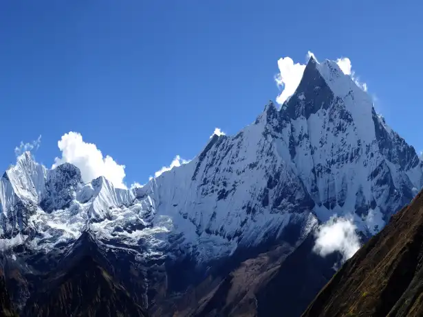
Machhapuchhre
6,993
Sacred fishtail shape, unclimbed
Annapurna II
7,937
Part of massif, trekking backdrop
Annapurna III
7,555
Eastern range highlight.
Major Peaks in the Area:
Cultural and Tourism Highlights:
Population: Over 100,000 from Gurung, Magar, Thakali groups
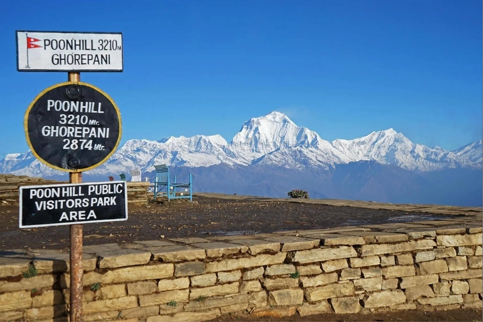
Trekking Routes: Annapurna Circuit, Sanctuary, Poon Hill (3,210 m) for sunrises
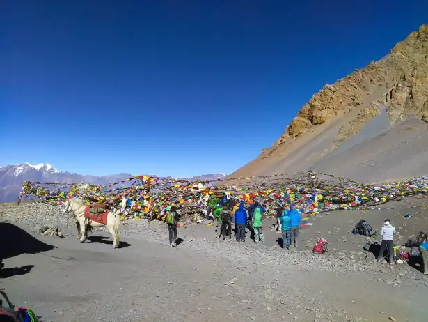
Attractions: Muktinath Temple (3,800 m), Thorong La Pass (5,416 m)
Sustainability: ACAP funds community projects from entry fees
Major Flora and Fauna in Annapurna Conservation Area
The Annapurna Conservation Area bursts with plant life, and it changes as you climb. Down low, around 1,000 meters, subtropical forests fill up with Schima wallichii and Castanopsis indica. As you go higher, rhododendrons steal the show every spring, painting the hills with color. Alpine meadows take over up top, and along the way, orchids and wildflowers line the trails.
The Annapurna Conservation Area is rich in biodiversity, with colorful rhododendron forests, pine woodlands, Himalayan monals (Danphe), langur monkeys, butterflies, and diverse wildlife thriving beneath the majestic Himalayan peaks.
All these plants do more than just look good—they help entire ecosystems, draw in pollinators, and keep things running smoothly. Conservation here isn’t just a buzzword, either. Protecting rare species is an active, ongoing effort. Honestly, the flora alone makes this place unforgettable.
Actually, wildlife here is just as impressive. You get 105 mammal species, from snow leopards prowling above 3,000 meters to red pandas tucked away in the temperate forests. Himalayan tahr navigate the rocky cliffs like it’s nothing. If you’re into birds, you’re in luck—523 species call this area home, including the striking Impeyan pheasant. Add in a mix of reptiles and amphibians, and the biodiversity really stands out. No wonder nature lovers flock here—there’s nowhere quite like it.
Flowering Plants: 1,226 species, including 9 rhododendron types in Ghorepani forests (2,860 m)
Subtropical Flora: Schima wallichii, Castanopsis indica at lower elevations (around 1,000 m)
Alpine Vegetation: Meadows with orchids, primulas at higher zones
Endemic Plants: Rare species protected in diverse ecosystems
Category
Count
Examples | Habitat Elevation
Mammals
105
Snow leopard, red panda, musk deer | Above 3,000 m for predators.
Birds
523
Impeyan pheasant, Spiny Babbler | Varied, forests to alpine.
Reptiles
40
Himalayan pit viper, geckos | Lower to mid elevations.
Amphibians
23
Himalayan newt, toads | Moist areas up to 3,000 m.
Fauna Diversity Overview:
Endangered and Notable Species:
Snow Leopard: Elusive, preys on blue sheep in high altitudes
Red Panda: Temperate bamboo forests, endangered
Himalayan Tahr: Rocky cliffs, commonly sighted
Musk Deer: Forests, valued for musk but protected
Best Time to Visit Annapurna Conservation Area
If you want the best experience in the Annapurna Conservation Area, plan your trip for spring (March to May) or autumn (September to November). These months bring steady weather and clear skies—perfect for soaking in those mountain views. Daytime temps at lower elevations hang around a comfortable 15 to 20°C, and while nights do get cool, it’s nothing you can’t handle. You’ll dodge most of the rain, and the visibility of giants like Annapurna I is tough to beat. Spring even throws in a bonus: bright rhododendron blooms everywhere you look. No wonder the trails fill up, especially in October. If you’re after the classic trekking experience, spring and autumn are tough to top.
Other times of year have their own flavor, but they come with challenges. Summer (June to August) brings the monsoon—think rainy days, muddy trails, and clouds hiding the peaks. On the bright side, you won’t be fighting crowds. Winter (December to February) pushes temperatures down, especially once you get above 3,000 meters, and high passes like Thorong La get buried in snow. Still, if you know what you’re doing, you get crisp air, quiet trails, and those sharp winter panoramas. In the end, timing your visit with the weather not only keeps you safe but makes the whole experience a lot more memorable.
Seasonal Overview for Visiting:
Spring (March-May): Mild weather, rhododendron blooms, clear views
Autumn (September-November): Peak season, stable skies, best visibility
Winter (December-February): Cold and snowy highs, quiet trails
Month
Day Temp (°C) | Night Temp (°C)
Rainfall Risk | Best For
March
10-18 | 0 to -5
Low | Early blooms, fewer crowds
April
12-20 | -2 to 5
Low | Rhododendrons peak
May
15-22 | 5-10
Moderate | Warm days, hazy later
September
15-22 | 5-10
Moderate | Post-monsoon recovery
October
12-20 | 0-8
Low | Clear skies, peak views
November
10-18 | -5 to 5
Low | Crisp air, fewer crowds
Monthly Temperature and Conditions (Approximate at Mid-Elevations):
Tips for Choosing Your Visit Time:
Avoid June-August for heavy rain and landslides
Pack layers for temperature drops at higher elevations like Tilicho Lake (4,919 m)
Book permits and lodges early in peak months (October, April)
Major Activities You Do During Your Visit to Annapurna Conservation Area
Actually, thrilling trekking pulls people into the Annapurna Conservation Area more than anything else. Following trails such as the Annapurna Circuit becomes common once they arrive. Around the massive cluster of mountains it winds, where summits rise - Annapurna I hits 8,091 meters. Shorter paths also draw folks toward Annapurna Base Camp or the Sanctuary nearby. High mountain crossings like Thorong La draw climbers up to 5,416 meters. Scattered trails lead off toward sweeping vistas. Effort mixes closely with breathtaking scenery along the way. Being ready makes a difference when altitude shifts without warning. Most people come mainly to walk these paths.
Some travelers find village life more memorable than mountain trails. Through narrow paths they reach homes where Gurung families share stories over tea. Hidden among cliffs, Braka Monastery hums with morning chants. Instead of rushing ahead, many pause there to listen. Higher up, movement in the trees might mean a red panda darting through fog. When tired, some sit by steaming pools near Tatopani. Snow leopards leave tracks others only dream of seeing. From hiking trails to quiet moments by the lake, choices shift with mood. Whether chasing views or sitting still, something fits how you feel that day.
Primary Trekking Activities:
Annapurna Circuit: Multi-day loop through diverse landscapes and cultures
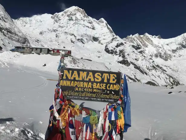
Annapurna Base Camp Trek: Ascent to 4,130 m viewpoint
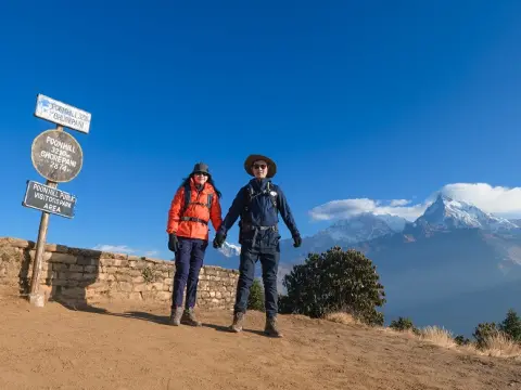
Poon Hill Sunrise Trek: Short hike to 3,210 m for Himalayan panoramas
Ghorepani to Tadapani: Rhododendron forest trails
Activity
Location/Elevation
Description
Visit Muktinath Temple
3,800 m
Sacred site for Hindus and Buddhists
Explore Manang Village
3,500 m
Acclimatization stop with monasteries
Gurung Village Homestay Ghandruk
1,940 m
Experience local dances and hospitality
Braka Monastery Visit Near Manang
3,500 m
Ancient Tibetan Buddhist site
Cultural and Sightseeing Activities:
Wildlife and Nature Activities:
Birdwatching: Over 523 species in varied habitats
Wildlife Spotting: Red panda in temperate forests, Himalayan tahr on cliffs
Photography: Capture Kali Gandaki Gorge and Tilicho Lake (4,919 m)
Relaxation: Hot springs in Jhinu Danda or natural viewpoints
General Rules to Follow While Visiting Annapurna Conservation Area
If you’re heading into the Annapurna Conservation Area, you need to play by some important rules to help protect this place. First off, always stick to the marked trails—no shortcuts, no wandering off. Don’t even think about collecting plants, rocks, or fossils, especially in sensitive spots like the high elevations near Annapurna I (8,091 m). Give wildlife plenty of space—at least 50 meters. It’s not just a suggestion; it keeps both you and the animals safe.
When it comes to waste, use the established toilets, and pack out anything that doesn’t break down naturally. Burning trash? Not allowed, period. These habits aren’t just rules—they’re how we keep the area’s biodiversity and cultural sites intact for the future.
Dhampus-Sarangkot Trek with Chitwan 8 days | 8 days
Likewise, responsible trekkers also respect local traditions. In villages like Ghandruk (1,940 m) or Manang (3,500 m), you show courtesy and follow local customs. Cut down on plastic by refilling water at filtered stations, and support the community lodges—they keep money in the local economy. Single-use plastics have no place here, especially in restricted areas.
Every eco-friendly step you take matters. Stick to the guidelines, and you help strike that balance between adventure and conservation. That’s what keeps the Annapurna experience special for everyone.
Key Conservation Rules:
Stay on marked trails; avoid shortcuts to prevent erosion
Carry out all non-biodegradable waste; no littering or burning
Do not disturb wildlife; maintain 50m distance
Use designated camping and toilet facilities only
Respect cultural sites; no removal of artifacts
Rule
Description
Reason
No collection of natural items
Plants, rocks, fossils forbidden
Protects ecosystems around Tilicho Lake (4,919 m)
Plastic restriction
Limit single-use; use refill stations
Reduces pollution in Kali Gandaki Gorge
Respect locals
Follow customs, ask permission for photos
Supports communities near Annapurna Circuit
Guide requirement
Foreigners often need licensed guide
Enhances safety and rule enforcement
Waste management
Sort and carry out trash
Prevents environmental degradation
Responsible Trekking Practices:
Additional Guidelines:
Acclimatize properly at higher elevations like Thorong La Pass (5,416 m)
Follow checkpoint checks for permits and compliance
Support local economies by using teahouses and homestays
Entry Tickets and Fees for the Annapurna Conservation Area
Before you set foot in the Annapurna Conservation Area, you need an entry permit—specifically, the Annapurna Conservation Area Permit (ACAP). This isn’t just a formality. Your fee goes straight into protecting the area’s 7,629 square kilometers, keeping the trails in shape, and supporting local communities. You pay at official entry points, and in some cases, you’ll need a TIMS card too, which helps keep trekkers safe and accounted for. Kids under 10 usually get in free, which is a nice bonus for families.Here,
Annapurna Conservation Area Permit prices depend on where you’re from. Foreigners pay more than SAARC nationals or Nepali citizens. You can get your permit online or in person in Kathmandu or Pokhara—whichever works for you. As you hike, expect checkpoints along the way where rangers will check your documents. The fees don’t just disappear into bureaucracy—they actually make a difference locally, funding everything from conservation to community projects. This system keeps the Annapurna region, peaks like Annapurna I (8,091 m), and gems like Tilicho Lake (4,919 m) accessible and thriving for everyone. Just get your permits sorted, and you’re good to go.
ACAP: Mandatory for all entering the conservation area
TIMS Card: Required for some treks (tracking and safety)
Validity: Covers entire itinerary duration
Where to Obtain: NTNC offices in Kathmandu/Pokhara or online
Nationality/Category ACAP Fee (NPR)
Approx. USD
Notes
Foreign Nationals (Non-SAARC) 3,000
25 - 30
13% VAT included
SAARC Nationals 1,000
8 - 10
Reduced rate
Nepali Nationals 100-300
1 - 3
Often minimal
Children under 10 Free
Free
With accompanying adult
Current Entry Fees (Approximate 2026):
Additional Fees and Tips:
TIMS Card (if required): NPR 2,000 (solo) or 1,000 (group) for foreigners
Online Payment: May add small processing fee
Checkpoints: Fees double if bought at entry points
Documents Needed: Passport copy, photos, filled form
Purpose: Funds conservation, education, health in districts
Access to Annapurna Conservation Area from Kathmandu
Most people heading to the Annapurna Conservation Area start from Kathmandu, moving onward to Pokhara - the usual entry point. From there, it's about 200 kilometers to reach Pokhara, possible by plane or vehicle. Flying cuts travel time down to roughly half an hour, giving passengers sweeping mountain sights - Annapurna I at 8,091 meters stands out clearly. On the other hand, taking a bus unfolds a slower trip of nearly eight hours, winding through landscapes beside the Prithvi Highway. Private cars bring ease plus a relaxed ride. That means travelers can get to spots such as Nayapul or Besisahar near Pokhara. Once past those towns, rougher roads need jeep rides instead. All in all, good travel links help hikers arrive without trouble.
The Annapurna Conservation Area is easily accessible from Kathmandu by tourist bus or private jeep, offering a scenic journey to Pokhara and the trekking trailheads for unforgettable Himalayan adventures.
From Pokhara, travelers head toward starting points of the protected area. A one to two hour ride takes them to Nayapul - gateway for Annapurna Base Camp paths - or onward to Ghorepani. Buses rolling directly from Kathmandu reach Besisahar in six or seven hours; that’s where treks around the Circuit begin. Rough terrain? Jeeps manage those stretches without trouble. Permits though - that step happens earlier, sorted out in either Kathmandu or Pokhara. Few choices fit varied costs and schedules. In total, access helps many each year reach heights between 790 m and steep crossings such as Thorong La at 5,416 m.
Flight to Pokhara: 25-30 minutes, scenic views of Annapurna massif
Tourist Bus to Pokhara: 7-8 hours, affordable and comfortable
Private Car/Jeep: 5-7 hours, flexible stops and direct trailhead access
Direct Bus to Besisahar: 7-8 hours for Circuit start
Trailhead Distance/Time from Pokhara
Vehicle Type
Best For
Nayapul / 1.5 - 2 hours
Bus/Jeep
Annapurna Base Camp, Ghorepani
Ghandruk / 2-3 hours
Jeep/Local bus
Cultural villages, Sanctuary trek
Ulleri / 3-4 hours
Jeep Local Bus
ABC Trek via Poon hill beginning point
Jhino Danda / 3-4 hours
Jeep/Local Bus
Direct Start of ABC Trek
Besisahar Direct from Kathmandu (or via Pokhara)
Bus/Jeep
Annapurna Circuit start
Chame / 5-6 hours drive
Private Jeep
Shorter Circuit routes
From Pokhara to Trailheads:
Tips for Smooth Accessibility:
Book flights early for clear weather views
Use tourist buses for budget travel with rest stops
Hire jeeps for groups to reach higher starting points like Chame (2,670 m)
Allow 1-2 days in Kathmandu/Pokhara for permits and acclimatization
Sustainable Tourism in Annapurna Conservation Area
Out here in the Annapurna Conservation Area, sustainable tourism grows because people take charge themselves. Running across 7,629 square kilometers, the area stays protected thanks to ACAP's steady oversight. When choices need making, village groups step in to help shape them. Because of this setup, money from visitor permits flows back into protecting nature and lifting communities up. Tourism can ease pressure on nature, yet still help local people thrive. Near high summits such as Annapurna I (8,091 m), careful actions keep ecosystems intact. Instead of erasing traditions, these efforts uphold village culture. Adventure here walks beside lasting care, shaping a steady path forward.
Here, some villages now use clean energy instead of burning wood. Solar panels power guesthouses where open fires once smoked. Cleaner cookstoves help lower smoke inside homes. Around Tilicho Lake, people keep trash out of streams using smart collection spots. Money earned from visitors goes into schools, clinics, hospitals. New roads reach remote areas thanks to shared income plans. Teahouses open doors for work, while guides find steady roles too. Still, it’s the quiet choices that let tourism lift lives - without harming nature along the way.
Community Management: Local committees oversee trails, forests, and wildlife
Revenue Allocation: Entry fees fund schools, clinics, and conservation
Energy Alternatives: Solar heaters and kerosene replace firewood in lodges
Waste Control: Designated systems and no-litter policies
Cultural Preservation: Training to maintain traditions and heritage sites
Benefit
Description
Impact on Locals/Environment
Economic Empowerment
Jobs in lodges, guiding, handicrafts
Over 5,000 employed, income generation
Infrastructure Development
Schools health posts
Trails maintained Improved living standards in remote villages
Biodiversity Protection
Forest management anti-poaching
Preserves habitats for snow leopards red pandas
Social Equity
Inclusive participation across castes/genders
Reduces inequality, empowers marginalized groups
Reduced Impact
Eco-guidelines for trekkers
Minimizes erosion, pollution in high areas
Benefits of Sustainable Tourism:
ACAP Initiatives and Outcomes:
Training Programs: Lodge owners learn sanitation, energy efficiency
Heritage Focus: Controlled tourism in Upper Mustang preserves culture
Self-Organization: Entrepreneurs diversify livelihoods during challenges
Equitable Sharing: Benefits reach on/off main routes fairly
FAQs for " Annapurna Conservation Area "
1. What is the Annapurna Conservation Area? The Annapurna Conservation Area is a special place in Nepal. It is the protected area in the country and it covers 7,629 square kilometers. You will see landscapes here from warm valleys to very high mountains like Annapurna I, which is 8,091 meters tall. The Annapurna Conservation Area has a lot of plants and animals and many different cultures. There are also trails that people like to hike on. We can help you visit the Annapurna Conservation Area in a way so you can have a safe and fun trip and also help take care of the area.
2. Why was the Annapurna Conservation Area established? The Annapurna Conservation Area was created in 1992. Before that there was a test project in a place called Ghandruk in 1986. The goal was to find a balance between taking care of the environment and helping the communities. The king of Nepal at the time King Birendra wanted to make sure that tourism did not hurt the environment. Today when you visit the Annapurna Conservation Area you have to pay a fee. This money is used to help the local communities and take care of the environment. We know a lot about the Annapurna Conservation Area so we can help you visit in a way that's good for everyone.
3. What are the major highlights and peaks in the Annapurna Conservation Area? The Annapurna Conservation Area has amazing things to see. There is the Kali Gandaki Gorge, which's the deepest gorge in the world. There is also a lake called Tilicho Lake, which is 4,919 meters above sea level. You can see forests of rhododendron trees and many high mountains like Annapurna I, Dhaulagiri and Machhapuchhre. The Annapurna Conservation Area also has cultural sites, which make the area very interesting to visit. We have been guiding people in the Annapurna Conservation Area for a time so we can help you see all the best things in a safe and beautiful way.
4. What permits do I need for the Annapurna Conservation Area? To visit the Annapurna Conservation Area you need to get a permit called the Annapurna Conservation Area Permit or ACAP for short. For some hikes you also need a TIMS card, which helps us keep track of you for safety reasons. You have to have these permits to enter the area so we can help you get them in Kathmandu or Pokhara before you start your trip. This way you can focus on having fun. Do not have to worry about the permits.
5. How much does the ACAP permit cost? The cost of the ACAP permit is around NPR 3,000 for people from countries, which is like USD 23-30. For people from SAARC countries the cost is NPR 1,000. For people from Nepal the cost is very low. Children under 10 years old can often enter for free. The money from the permits is used to take care of the environment and help the communities. We can help you get your permit quickly and easily so you can start your trip without any problems.
6. What is the best time to visit the Annapurna Conservation Area? The best time to visit the Annapurna Conservation Area is in the spring from March to May or in the autumn from September to November. During these times the weather is usually clear and stable. The views are very beautiful. In the spring you can see the rhododendron trees blooming and in the autumn you can see the mountains clearly. We think these are the times to visit because we have been guiding people in the Annapurna Conservation Area for a long time and we know when the conditions are the best.
7. What flora and fauna can I see in the Annapurna Conservation Area? The Annapurna Conservation Area has a lot of plants and animals. You can see over 1,226 kinds of flowering plants including rhododendron trees. There are also 105 kinds of mammals like snow leopards and red pandas and 523 kinds of birds. The area has different habitats from warm forests to cold alpine meadows. Our guides are very knowledgeable. Can help you see many of these plants and animals while we are hiking.
8. What trekking routes and activities are available? There are things you can do in the Annapurna Conservation Area. You can hike on trails, like the Annapurna Circuit or the Base Camp Trek. You can also visit the Muktinath Temple or the Gurung villages to learn about the culture. We can help you plan your trip based on what you like to do and how fit you are so you can have an fun trip.
9. What are the rules that visitors need to follow when they come to visit? You need to stay on the trails that are marked. You need to take your waste with you when you leave. You also need to keep a distance from the animals that live here. You need to respect the customs of the people who live here. Do not use things that you can only use once and try to help the local people by staying in their lodges. If you do these things you will help keep the environment clean and nice. We have been doing this for a time so we can help your group follow these rules and have a good time.
10. How do I get to Annapurna Conservation Area from Kathmandu? You can fly to Pokhara, which takes about 25 to 30 minutes. You can take a bus, which takes about 7 to 8 hours. Then you can take a jeep or a bus to the starting points of the trails like Nayapul or Besisahar. We can help you get there so you can enjoy the views and start your trek feeling fresh.
11. How does tourism that is good for the environment work in Annapurna? The people in charge of Annapurna Conservation Area use the money from the permits to help the communities and to protect the environment. They use the money to make energy and to manage the waste. We try to make our tours good for the environment so we do not hurt the people or the nature.
12. Is Annapurna Conservation Area a place for people who are trekking for the first time? Yes it is, especially if you take the routes like Poon Hill or Annapurna Base Camp. These routes are not too hard. They have good facilities. If you prepare well and have a guide you can do it. We have taken people on their first trek and we make sure they are safe and have a good time.
13. What things should I bring with me when I go trekking in Annapurna Conservation Area? You need to bring clothes that you can wear in layers strong boots, a rain jacket, sunscreen, a water bottle that you can use times, a headlamp and some basic medicines. You need to pack the things you need. Do not bring too much. We can help you make a list so you have everything you need to be comfortable and safe.
14. What kinds of things can I experience in the region? You can stay with families visit monasteries like Braka and go to festivals. You can learn about the traditions of the people who live here. They will be very welcoming. We can help you have interactions with the local people so you can learn more about their culture and help them.
15. Why should I choose a guided trek in Annapurna Conservation Area? If you have a guide who knows what they are doing you will be safer. You will have a better time. The guide can help you navigate teach you about the culture and make sure you follow the rules. This way you can just enjoy your trek. Do not have to worry about anything. We have been doing this for a time so we can help you have a good and memorable trip, to Annapurna Conservation Area.