[{"name":"Everest Base Camp Helicopter Tour","duration":"1","image_url":"https:\/\/www.havenholidaysnepal.com\/storage\/trip-galleries\/1\/thumb_6cd53005d75a86e373d31419d1b14d78.webp","offer_price":1195,"url":"https:\/\/www.havenholidaysnepal.com\/trips\/everest-base-camp-helicopter-tour"},{"name":"Everest Mountain Flight","duration":"1","image_url":"https:\/\/www.havenholidaysnepal.com\/storage\/trip-galleries\/4\/thumb_3b0b4f1d6f72b0ad224daf4752f2c6e0.jpg","offer_price":285,"url":"https:\/\/www.havenholidaysnepal.com\/trips\/everest-mountain-flight"},{"name":"Everest Short Trek","duration":"9","image_url":"https:\/\/www.havenholidaysnepal.com\/storage\/trip-galleries\/5\/thumb_BXPP3621.JPEG0.02033800 1727957098.webp","offer_price":895,"url":"https:\/\/www.havenholidaysnepal.com\/trips\/everest-short-trek"},{"name":"Gokyo Valley Trek","duration":"12","image_url":"https:\/\/www.havenholidaysnepal.com\/storage\/trip-galleries\/6\/thumb_10bc469b14731f23d3ce84a7092ad53f.jpg","offer_price":1195,"url":"https:\/\/www.havenholidaysnepal.com\/trips\/gokyo-valley-trek"},{"name":"15 days Annapurna Base Camp Trek","duration":"15","image_url":"https:\/\/www.havenholidaysnepal.com\/storage\/trip-galleries\/7\/thumb_87d1533bc45faf070990aef0579e4be4.jpg0.81855100 1728285496.webp","offer_price":785,"url":"https:\/\/www.havenholidaysnepal.com\/trips\/15-days-annapurna-base-camp-trek"},{"name":"Nepal Pilgrimage Tour","duration":"14","image_url":"https:\/\/www.havenholidaysnepal.com\/storage\/trip-galleries\/8\/thumb_02c3bcf2ad2e8a4c1703e90ae747b5f1.jpg","offer_price":1475,"url":"https:\/\/www.havenholidaysnepal.com\/trips\/nepal-pilgrimage-tour"},{"name":"UNESCO World Heritage Site Tour","duration":"10","image_url":"https:\/\/www.havenholidaysnepal.com\/storage\/trip-galleries\/9\/thumb_unesco-world-heritage-site-Lumbani-temple-buddhists-hindus-kathmandu-nepal0.36988600 17347617740.93089500 1737469667.webp","offer_price":715,"url":"https:\/\/www.havenholidaysnepal.com\/trips\/unesco-world-heritage-site-tour"},{"name":"Island Peak Climbing","duration":"16","image_url":"https:\/\/www.havenholidaysnepal.com\/storage\/trip-galleries\/11\/thumb_Island peak0.53947000 1734692503.webp","offer_price":2495,"url":"https:\/\/www.havenholidaysnepal.com\/trips\/island-peak-climbing"},{"name":"Upper Mustang Trek","duration":"18","image_url":"https:\/\/www.havenholidaysnepal.com\/storage\/trip-galleries\/12\/thumb_upper mustang 7 Oct-2024.jpg0.95398900 1728286166.webp","offer_price":2995,"url":"https:\/\/www.havenholidaysnepal.com\/trips\/upper-mustang-trek"},{"name":"Annapurna Circuit Trek","duration":"16","image_url":"https:\/\/www.havenholidaysnepal.com\/storage\/trip-galleries\/15\/thumb_tibetan-flags.jpg0.04843900 1728289138.webp","offer_price":985,"url":"https:\/\/www.havenholidaysnepal.com\/trips\/annapurna-circuit-trek"},{"name":"Gosainkunda Lake Trek","duration":"10","image_url":"https:\/\/www.havenholidaysnepal.com\/storage\/trip-galleries\/16\/thumb_5A8083B3-C007-41A8-853F-D0C37C97D235_1_105_c.jpeg0.52581200 1731845258.webp","offer_price":595,"url":"https:\/\/www.havenholidaysnepal.com\/trips\/gosainkunda-lake-trek"},{"name":"Zip-lining in Pokhara and Dhulikhel","duration":"1","image_url":"https:\/\/www.havenholidaysnepal.com\/storage\/trip-galleries\/18\/thumb_215f765e2ebc995dd5c800b4bfdbacc3.jpg","offer_price":82,"url":"https:\/\/www.havenholidaysnepal.com\/trips\/zip-lining-in-pokhara-and-dhulikhel"},{"name":"Annapurna Heli Tour","duration":"1","image_url":"https:\/\/www.havenholidaysnepal.com\/storage\/trip-galleries\/19\/thumb_d71a6bbb9fd4da8d1b567a5cdbdec85d.jpg","offer_price":555,"url":"https:\/\/www.havenholidaysnepal.com\/trips\/annapurna-heli-tour"},{"name":"Paragliding in Pokhara","duration":"1","image_url":"https:\/\/www.havenholidaysnepal.com\/storage\/trip-galleries\/20\/thumb_de788d2dd9726783431f882c007efae1.jpg","offer_price":65,"url":"https:\/\/www.havenholidaysnepal.com\/trips\/paragliding-in-pokhara"},{"name":"Ultra-Flight in Pokhara","duration":"1","image_url":"https:\/\/www.havenholidaysnepal.com\/storage\/trip-galleries\/21\/thumb_e27a9fb572a5c21611bb2a3c18e4b8f0.jpeg","offer_price":175,"url":"https:\/\/www.havenholidaysnepal.com\/trips\/ultra-flight-in-pokhara"},{"name":"Sarangkot Hiking","duration":"1","image_url":"https:\/\/www.havenholidaysnepal.com\/storage\/trip-galleries\/22\/thumb_100ef822fea19987166c6c1366215f15.jpg","offer_price":55,"url":"https:\/\/www.havenholidaysnepal.com\/trips\/sarangkot-hiking"},{"name":"Mera Peak Climbing","duration":"18","image_url":"https:\/\/www.havenholidaysnepal.com\/storage\/trip-galleries\/24\/thumb_d16ae3895f678cf26ffbf2455f541fb5.jpg0.31883400 1732617790.webp","offer_price":2475,"url":"https:\/\/www.havenholidaysnepal.com\/trips\/mera-peak-climbing"},{"name":"Lower Dolpo Trek","duration":"18","image_url":"https:\/\/www.havenholidaysnepal.com\/storage\/trip-galleries\/26\/thumb_Dolpo Galary - 1.JPG0.37725200 1727939952.webp","offer_price":2995,"url":"https:\/\/www.havenholidaysnepal.com\/trips\/lower-dolpo-trek"},{"name":"Nagarkot Sunrise\/Sunset Tour","duration":"1","image_url":"https:\/\/www.havenholidaysnepal.com\/storage\/trip-galleries\/27\/thumb_5147a5532644283a380f2e86f3857c13.jpg0.17748000 1728488108.webp","offer_price":30,"url":"https:\/\/www.havenholidaysnepal.com\/trips\/nagarkot-sunrise-sunset-tour"},{"name":"16 day Everest Base Camp Trek","duration":"16","image_url":"https:\/\/www.havenholidaysnepal.com\/storage\/trip-galleries\/28\/thumb_IMG_4311.JPG0.64984800 1727942213.webp","offer_price":1475,"url":"https:\/\/www.havenholidaysnepal.com\/trips\/16-day-everest-base-camp-trek"},{"name":"Ghorepani Poon Hill trek with Jungle Safari and Trishuli River Rafting -13 days","duration":"13","image_url":"https:\/\/www.havenholidaysnepal.com\/storage\/trip-galleries\/29\/thumb_Ghorepani Poon hill.jpg0.48460800 1728281439.webp","offer_price":795,"url":"https:\/\/www.havenholidaysnepal.com\/trips\/ghorepani-poon-hill-trek-with-jungle-safari-and-trishuli-river-rafting--13-days"},{"name":"Mardi Himal Trek","duration":"12","image_url":"https:\/\/www.havenholidaysnepal.com\/storage\/trip-galleries\/30\/thumb_s1.jpg0.62112600 1728200721.webp","offer_price":795,"url":"https:\/\/www.havenholidaysnepal.com\/trips\/mardi-himal-trek"},{"name":"Langtang Valley Trekking","duration":"10","image_url":"https:\/\/www.havenholidaysnepal.com\/storage\/trip-galleries\/31\/thumb_IMG_4702.JPG0.84916500 1727958504.webp","offer_price":685,"url":"https:\/\/www.havenholidaysnepal.com\/trips\/langtang-valley-trekking"},{"name":"Real Adventure Tour in Nepal","duration":"9","image_url":"https:\/\/www.havenholidaysnepal.com\/storage\/trip-galleries\/32\/thumb_ebd1b8cc78d90abe8b9003dd9a2f25bf.jpg0.82151300 1728213516.webp","offer_price":695,"url":"https:\/\/www.havenholidaysnepal.com\/trips\/real-adventure-tour-in-nepal"},{"name":"Luxury Tour in Nepal","duration":"10","image_url":"https:\/\/www.havenholidaysnepal.com\/storage\/trip-galleries\/33\/thumb_8574e61b252b18676b042caf30d830df.jpg","offer_price":1675,"url":"https:\/\/www.havenholidaysnepal.com\/trips\/luxury-tour-in-nepal"},{"name":"Luxury Everest Panorama Trek With EBC Heli Sightseeing","duration":"8","image_url":"https:\/\/www.havenholidaysnepal.com\/storage\/trip-galleries\/34\/thumb_URZL2397.JPEG0.01209600 1728027820.webp","offer_price":2395,"url":"https:\/\/www.havenholidaysnepal.com\/trips\/luxury-everest-panorama-trek-with-ebc-heli-sightseeing"},{"name":"13 day Everest Base Camp Trek with Helicopter","duration":"13","image_url":"https:\/\/www.havenholidaysnepal.com\/storage\/trip-galleries\/35\/thumb_IMG_4292.JPG0.70131500 1728029276.webp","offer_price":2095,"url":"https:\/\/www.havenholidaysnepal.com\/trips\/13-day-everest-base-camp-trek-with-helicopter"},{"name":"Manaslu Circuit Trek","duration":"16","image_url":"https:\/\/www.havenholidaysnepal.com\/storage\/trip-galleries\/36\/thumb_Mt Manaslu 03-Oct-2024.jpg0.65804900 1727938470.webp","offer_price":955,"url":"https:\/\/www.havenholidaysnepal.com\/trips\/manaslu-circuit-trek"},{"name":"Kanchenjunga Base Camp Trek","duration":"21","image_url":"https:\/\/www.havenholidaysnepal.com\/storage\/trip-galleries\/37\/thumb_Kanchanjunga Trek -!.jpg0.54744400 1727938497.webp","offer_price":2275,"url":"https:\/\/www.havenholidaysnepal.com\/trips\/kanchenjunga-base-camp-trek"},{"name":"Ganesh Himal and Sing-La Trek","duration":"18","image_url":"https:\/\/www.havenholidaysnepal.com\/storage\/trip-galleries\/38\/thumb_Ganesh Himal slider-1.jpg0.43764500 1727937722.webp","offer_price":2975,"url":"https:\/\/www.havenholidaysnepal.com\/trips\/ganesh-himal-and-sing-la-trek"},{"name":"Island Peak Climb with Everest Base Camp Trek","duration":"21","image_url":"https:\/\/www.havenholidaysnepal.com\/storage\/trip-galleries\/39\/thumb_2be428730fe83525bc85a010564f99de.jpg","offer_price":2750,"url":"https:\/\/www.havenholidaysnepal.com\/trips\/island-peak-climb-with-everest-base-camp-trek"},{"name":"Students' Adventure Tour in Nepal","duration":"12","image_url":"https:\/\/www.havenholidaysnepal.com\/storage\/trip-galleries\/41\/thumb_a926d22fbfe08cba271c41ac289b3fd2.jpg","offer_price":995,"url":"https:\/\/www.havenholidaysnepal.com\/trips\/students-adventure-tour-in-nepal"},{"name":"7 Day Poonhill Trek","duration":"7","image_url":"https:\/\/www.havenholidaysnepal.com\/storage\/trip-galleries\/42\/thumb_6196bd69036473293a2c24cc21ed57d7.jpg0.10880600 1728205378.webp","offer_price":555,"url":"https:\/\/www.havenholidaysnepal.com\/trips\/7-day-poonhill-trek"},{"name":"7 Days Annapurna Base Camp Trek","duration":"7","image_url":"https:\/\/www.havenholidaysnepal.com\/storage\/trip-galleries\/43\/thumb_IMG_2214.JPG0.08204900 1728202033.webp","offer_price":355,"url":"https:\/\/www.havenholidaysnepal.com\/trips\/7-days-annapurna-base-camp-trek"},{"name":"3 days Poonhill Trek","duration":"3","image_url":"https:\/\/www.havenholidaysnepal.com\/storage\/trip-galleries\/44\/thumb_Poon hill.jpg0.60816600 1731412954.webp","offer_price":165,"url":"https:\/\/www.havenholidaysnepal.com\/trips\/3-days-poonhill-trek"},{"name":"Poon Hill Luxury Trek with Chitwan-12 days","duration":"12","image_url":"https:\/\/www.havenholidaysnepal.com\/storage\/trip-galleries\/45\/thumb_Poom hill.jpg0.52074500 1730180532.webp","offer_price":1175,"url":"https:\/\/www.havenholidaysnepal.com\/trips\/poon-hill-luxury-trek-with-chitwan-12-days"},{"name":"Everest Luxury Trek-7 days","duration":"7","image_url":"https:\/\/www.havenholidaysnepal.com\/storage\/trip-galleries\/46\/thumb_ACRX9330.JPEG0.93236200 1728031275.webp","offer_price":2395,"url":"https:\/\/www.havenholidaysnepal.com\/trips\/everest-luxury-trek-7-days"},{"name":"Hindu Pilgrimage Tour in Nepal-10 days","duration":"10","image_url":"https:\/\/www.havenholidaysnepal.com\/storage\/trip-galleries\/47\/thumb_a94bf96a4d31decb419f6f828a3280d2.jpg","offer_price":995,"url":"https:\/\/www.havenholidaysnepal.com\/trips\/hindu-pilgrimage-tour-in-nepal-10-days"},{"name":"Everest Base Camp Short Trek-12 days","duration":"12","image_url":"https:\/\/www.havenholidaysnepal.com\/storage\/trip-galleries\/48\/thumb_IMG_4311.JPG0.52680100 1727945154.webp","offer_price":995,"url":"https:\/\/www.havenholidaysnepal.com\/trips\/everest-base-camp-short-trek-12-days"},{"name":"Everest Base Camp Hike 12 Days","duration":"12","image_url":"https:\/\/www.havenholidaysnepal.com\/storage\/trip-galleries\/49\/thumb_IMG_4260.JPG0.51729100 1728061234.webp","offer_price":1295,"url":"https:\/\/www.havenholidaysnepal.com\/trips\/everest-base-camp-hike-12-days"},{"name":"11 Days Everest Base Camp Trek","duration":"11","image_url":"https:\/\/www.havenholidaysnepal.com\/storage\/trip-galleries\/50\/thumb_IMG_4249.JPG0.21392500 1727946959.webp","offer_price":985,"url":"https:\/\/www.havenholidaysnepal.com\/trips\/11-days-everest-base-camp-trek"},{"name":"6 Days Annapurna Base Camp Trek","duration":"6","image_url":"https:\/\/www.havenholidaysnepal.com\/storage\/trip-galleries\/51\/thumb_6 days Abc.jpg0.58185400 1728200798.webp","offer_price":285,"url":"https:\/\/www.havenholidaysnepal.com\/trips\/6-days-annapurna-base-camp-trek"},{"name":"Annapurna Base Camp Trek","duration":"8","image_url":"https:\/\/www.havenholidaysnepal.com\/storage\/trip-galleries\/52\/thumb_IMG_2214.JPG0.29415700 1729487656.webp","offer_price":585,"url":"https:\/\/www.havenholidaysnepal.com\/trips\/annapurna-base-camp-trek"},{"name":"Everest Base Camp Trek with Helicopter Fly Out 10 Days","duration":"10","image_url":"https:\/\/www.havenholidaysnepal.com\/storage\/trip-galleries\/53\/thumb_IMG_4328.JPG0.52056600 1728058444.webp","offer_price":1875,"url":"https:\/\/www.havenholidaysnepal.com\/trips\/everest-base-camp-trek-with-helicopter-fly-out-10-days"},{"name":"Everest Base Camp Trek 14 Days","duration":"14","image_url":"https:\/\/www.havenholidaysnepal.com\/storage\/trip-galleries\/54\/thumb_Everest Base Camp Trek 14 days Oct 3 2024.JPG0.43202700 1727939745.webp","offer_price":1235,"url":"https:\/\/www.havenholidaysnepal.com\/trips\/everest-base-camp-trek-14-days"},{"name":"ABC Trek with Poonhill 11 Days","duration":"11","image_url":"https:\/\/www.havenholidaysnepal.com\/storage\/trip-galleries\/55\/thumb_ABC with fishtail.JPG0.21441100 1728277965.webp","offer_price":555,"url":"https:\/\/www.havenholidaysnepal.com\/trips\/abc-trek-with-poonhill-11-days"},{"name":"Muldai Hill Trek 9 Days","duration":"9","image_url":"https:\/\/www.havenholidaysnepal.com\/storage\/trip-galleries\/56\/thumb_7efee59f0a8c6817c8255bd2b9f3539d.jpeg0.19479300 1728213091.webp","offer_price":675,"url":"https:\/\/www.havenholidaysnepal.com\/trips\/muldai-hill-trek-9-days"},{"name":"Mardi Himal Trek 6 days","duration":"6","image_url":"https:\/\/www.havenholidaysnepal.com\/storage\/trip-galleries\/57\/thumb_slider 1.jpeg0.36909700 1728184981.webp","offer_price":590,"url":"https:\/\/www.havenholidaysnepal.com\/trips\/mardi-himal-trek-6-days"},{"name":"Mardi Himal Trek 7 days","duration":"7","image_url":"https:\/\/www.havenholidaysnepal.com\/storage\/trip-galleries\/58\/thumb_slider1.jpg0.61666600 1728206414.webp","offer_price":620,"url":"https:\/\/www.havenholidaysnepal.com\/trips\/mardi-himal-trek-7-days"},{"name":"Mardi Himal Trek 8 Days","duration":"8","image_url":"https:\/\/www.havenholidaysnepal.com\/storage\/trip-galleries\/59\/thumb_sli1.jpg0.38569100 1728206631.webp","offer_price":695,"url":"https:\/\/www.havenholidaysnepal.com\/trips\/mardi-himal-trek-8-days"},{"name":"14 Days Manaslu Trek","duration":"14","image_url":"https:\/\/www.havenholidaysnepal.com\/storage\/trip-galleries\/60\/thumb_sunrise-mt-manaslu-during-manaslu-circuit-larke-pass-trekking-himalaya-nepal (1)0.81855800 1738673284.webp","offer_price":885,"url":"https:\/\/www.havenholidaysnepal.com\/trips\/14-days-manaslu-trek"},{"name":"Dhampus-Sarangkot Trek with Chitwan 8 days","duration":"8","image_url":"https:\/\/www.havenholidaysnepal.com\/storage\/trip-galleries\/61\/thumb_Sarangkot Bhangyang.jpg0.75461400 1728210333.webp","offer_price":790,"url":"https:\/\/www.havenholidaysnepal.com\/trips\/dhampus-sarangkot-trek-with-chitwan-8-days"},{"name":"7 Days Golden Triangle Tour","duration":"7","image_url":"https:\/\/www.havenholidaysnepal.com\/storage\/trip-galleries\/62\/thumb_311ce1d117ee0ba75402a7c301bcdf830.73532400 1739179809.webp","offer_price":845,"url":"https:\/\/www.havenholidaysnepal.com\/trips\/7-days-golden-triangle-tour"},{"name":"Annapurna Circuit Trek 12 days","duration":"12","image_url":"https:\/\/www.havenholidaysnepal.com\/storage\/trip-galleries\/63\/thumb_IMG_20161024_092237.jpg0.57796600 1728289938.webp","offer_price":695,"url":"https:\/\/www.havenholidaysnepal.com\/trips\/annapurna-circuit-trek-12-days"},{"name":"Everest Base Camp Budget Trek 16 Days","duration":"16","image_url":"https:\/\/www.havenholidaysnepal.com\/storage\/trip-galleries\/64\/thumb_IMG_4423.JPG0.92579200 1728144669.webp","offer_price":958,"url":"https:\/\/www.havenholidaysnepal.com\/trips\/everest-base-camp-budget-trek-16-days"},{"name":"Poonhill Budget Trek 7 Days","duration":"7","image_url":"https:\/\/www.havenholidaysnepal.com\/storage\/trip-galleries\/65\/thumb_5be067852d0c5228d6f3155bc425c6b5.jpg","offer_price":395,"url":"https:\/\/www.havenholidaysnepal.com\/trips\/poonhill-budget-trek-7-days"},{"name":"Annapurna Base Camp Budget Trek 8 Days","duration":"8","image_url":"https:\/\/www.havenholidaysnepal.com\/storage\/trip-galleries\/66\/thumb_Pokhara.jpg0.16188000 1728212001.webp","offer_price":375,"url":"https:\/\/www.havenholidaysnepal.com\/trips\/annapurna-base-camp-budget-trek-8-days"},{"name":"The Real UNESCO Seven World Heritage Tour in Kathmandu 4 days","duration":"4","image_url":"https:\/\/www.havenholidaysnepal.com\/storage\/trip-galleries\/67\/thumb_Baudha Stupa.JPG0.63906900 1728201021.webp","offer_price":380,"url":"https:\/\/www.havenholidaysnepal.com\/trips\/the-real-unesco-seven-world-heritage-tour-in-kathmandu-4-days"},{"name":"Everest Base Camp Jeep Ride with Helicopter Return","duration":"14","image_url":"https:\/\/www.havenholidaysnepal.com\/storage\/trip-galleries\/68\/thumb_788ee5b63a6efb6f3c3d048b4270daca.JPG","offer_price":1895,"url":"https:\/\/www.havenholidaysnepal.com\/trips\/everest-base-camp-jeep-ride-with-helicopter-return"},{"name":"Annapurna Base Camp Jeep Ride with Helicopter Return 7 days","duration":"7","image_url":"https:\/\/www.havenholidaysnepal.com\/storage\/trip-galleries\/69\/thumb_abc jeep.jpg0.10280600 1728204064.webp","offer_price":1455,"url":"https:\/\/www.havenholidaysnepal.com\/trips\/annapurna-base-camp-jeep-ride-with-helicopter-return-7-days"},{"name":"Everest Base Camp Trek","duration":"15","image_url":"https:\/\/www.havenholidaysnepal.com\/storage\/trip-galleries\/70\/thumb_Everest Base Camp Trek 3 oct- 2024.JPG0.58445300 1727941472.webp","offer_price":1355,"url":"https:\/\/www.havenholidaysnepal.com\/trips\/everest-base-camp-trek"},{"name":"7 UNESCO World Heritage Tour Kathmandu 2 days","duration":"2","image_url":"https:\/\/www.havenholidaysnepal.com\/storage\/trip-galleries\/72\/thumb_Bhaktipur 3.jpg0.05559600 1728201496.webp","offer_price":150,"url":"https:\/\/www.havenholidaysnepal.com\/trips\/7-unesco-world-heritage-tour-kathmandu-2-days"},{"name":"Day Tour to UNESCO Heritage Sites","duration":"1","image_url":"https:\/\/www.havenholidaysnepal.com\/storage\/trip-galleries\/73\/thumb_228A1018.jpg0.79892500 1728199793.webp","offer_price":55,"url":"https:\/\/www.havenholidaysnepal.com\/trips\/day-tour-to-unesco-heritage-sites"},{"name":"Golden Triangle Tour in Nepal","duration":"8","image_url":"https:\/\/www.havenholidaysnepal.com\/storage\/trip-galleries\/74\/thumb_f54139cf9100f00015ffe0400687e946.webp","offer_price":588,"url":"https:\/\/www.havenholidaysnepal.com\/trips\/golden-triangle-tour-in-nepal"},{"name":"Everest Base Camp Honeymoon Tour by Helicopter with Pokhara","duration":"7 days","image_url":"https:\/\/www.havenholidaysnepal.com\/storage\/trip-galleries\/76\/thumb_RJTL7517.JPEG0.40261600 1731499989.webp","offer_price":9999,"url":"https:\/\/www.havenholidaysnepal.com\/trips\/everest-base-camp-honeymoon-tour-by-helicopter-with-pokhara"},{"name":"Yoga and Meditation Retreat Tour in Nepal","duration":"10 days","image_url":"https:\/\/www.havenholidaysnepal.com\/storage\/trip-galleries\/77\/thumb_decf8e33-6617-4400-9df0-63bf75509adf.JPG0.51948300 1731574810.webp","offer_price":2575,"url":"https:\/\/www.havenholidaysnepal.com\/trips\/yoga-and-meditation-retreat-tour-in-nepal"},{"name":"Chisapani-Nagarkot Trek","duration":"3","image_url":"https:\/\/www.havenholidaysnepal.com\/storage\/trip-galleries\/78\/thumb_0b64dfceaeab48ac36d685476bdebafb.webp","offer_price":165,"url":"https:\/\/www.havenholidaysnepal.com\/trips\/chisapani-nagarkot-trek"},{"name":"Chitwan Jungle Safari Tour","duration":"2","image_url":"https:\/\/www.havenholidaysnepal.com\/storage\/trip-galleries\/79\/thumb_IMG_1696.JPG0.28467800 1733054554.webp","offer_price":175,"url":"https:\/\/www.havenholidaysnepal.com\/trips\/chitwan-jungle-safari-tour"},{"name":"Kailash Overland Tour","duration":"16","image_url":"https:\/\/www.havenholidaysnepal.com\/storage\/trip-galleries\/80\/thumb_PA2605230.68496700 1735818657.webp","offer_price":2495,"url":"https:\/\/www.havenholidaysnepal.com\/trips\/kailash-overland-tour"},{"name":"4 nights 5 days Bhutan Tour","duration":"5","image_url":"https:\/\/www.havenholidaysnepal.com\/storage\/trip-galleries\/81\/thumb_PB0508470.23069500 1735828937.webp","offer_price":1265,"url":"https:\/\/www.havenholidaysnepal.com\/trips\/4-nights-5-days-bhutan-tour"},{"name":"Everest Base Camp Trek Without Flying","duration":"16","image_url":"https:\/\/www.havenholidaysnepal.com\/storage\/trip-galleries\/82\/thumb_308b054484eddc042e092e1ae2ae5586.webp","offer_price":685,"url":"https:\/\/www.havenholidaysnepal.com\/trips\/everest-base-camp-trek-without-flying"},{"name":"Everest Base Camp Trek by Land","duration":"16","image_url":"https:\/\/www.havenholidaysnepal.com\/storage\/trip-galleries\/83\/thumb_8f0f2784a3ae7343d193b64fe8d47c96.webp","offer_price":675,"url":"https:\/\/www.havenholidaysnepal.com\/trips\/everest-base-camp-trek-by-land"},{"name":"Everest Base Camp Trek by Jeep","duration":"16","image_url":"https:\/\/www.havenholidaysnepal.com\/storage\/trip-galleries\/84\/thumb_f82b3acdfc933bc3e0197624c001b0a6.webp","offer_price":675,"url":"https:\/\/www.havenholidaysnepal.com\/trips\/everest-base-camp-trek-by-jeep"},{"name":"Everest Base Camp Trek without Lukla Flight","duration":"16","image_url":"https:\/\/www.havenholidaysnepal.com\/storage\/trip-galleries\/85\/thumb_2d0acc76dc958e3122a3745074989914.webp","offer_price":675,"url":"https:\/\/www.havenholidaysnepal.com\/trips\/everest-base-camp-trek-without-lukla-flight"},{"name":"Langtang Valley Trek","duration":"7","image_url":"https:\/\/www.havenholidaysnepal.com\/storage\/trip-galleries\/86\/thumb_a845db06c5feada1478e8aed659fce97.webp","offer_price":199,"url":"https:\/\/www.havenholidaysnepal.com\/trips\/langtang-valley-trek"},{"name":"Everest Base Camp Trek with Gokyo Lake","duration":"17","image_url":"https:\/\/www.havenholidaysnepal.com\/storage\/trip-galleries\/87\/thumb_c6aa32f7654f2eda78134bc84ac70b79.webp","offer_price":1885,"url":"https:\/\/www.havenholidaysnepal.com\/trips\/everest-base-camp-trek-with-gokyo-lake"},{"name":"Everest Three Passes Trek","duration":"19","image_url":"https:\/\/www.havenholidaysnepal.com\/storage\/trip-galleries\/88\/thumb_db5364eaab56f5755da55868f8ca4258.webp","offer_price":1735,"url":"https:\/\/www.havenholidaysnepal.com\/trips\/everest-three-passes-trek"},{"name":"Annapurna Base Camp Trek From Pokhara","duration":"5","image_url":"https:\/\/www.havenholidaysnepal.com\/storage\/trip-galleries\/89\/thumb_49c813cf1054ff06108963924a78ee88.webp","offer_price":255,"url":"https:\/\/www.havenholidaysnepal.com\/trips\/annapurna-base-camp-trek-from-pokhara"},{"name":"Sarangkot Sunrise Tour from Pokhara","duration":"1","image_url":"https:\/\/www.havenholidaysnepal.com\/storage\/trip-galleries\/90\/thumb_932d995b8fb702634a23e8f9a0432c6e.webp","offer_price":35,"url":"https:\/\/www.havenholidaysnepal.com\/trips\/sarangkot-sunrise-tour-from-pokhara"},{"name":"Langtang Valley Trek-8 days","duration":"8","image_url":"https:\/\/www.havenholidaysnepal.com\/storage\/trip-galleries\/91\/thumb_81d3d0a6979c9ed01f65d5ade53820b2.webp","offer_price":250,"url":"https:\/\/www.havenholidaysnepal.com\/trips\/langtang-valley-trek-8-days"},{"name":"Manaslu Circuit Trek 12 days","duration":"12","image_url":"https:\/\/www.havenholidaysnepal.com\/storage\/trip-galleries\/92\/thumb_d8251bbef0c8a246a02bda5c150a27c2.webp","offer_price":675,"url":"https:\/\/www.havenholidaysnepal.com\/trips\/manaslu-circuit-trek-12-days"},{"name":"2 Days Poon Hill Trek","duration":"2","image_url":"https:\/\/www.havenholidaysnepal.com\/storage\/trip-galleries\/93\/thumb_9d8fa8f60767538857d6c7cb3a7fee8b.webp","offer_price":135,"url":"https:\/\/www.havenholidaysnepal.com\/trips\/2-days-poon-hill-trek"},{"name":"Upper Mustang Jeep Tour","duration":"6","image_url":"https:\/\/www.havenholidaysnepal.com\/storage\/trip-galleries\/94\/thumb_9a3098a6c860b87ad3339773ef5435b9.webp","offer_price":1095,"url":"https:\/\/www.havenholidaysnepal.com\/trips\/upper-mustang-jeep-tour"},{"name":"Tsum Valley Trek","duration":"11","image_url":"https:\/\/www.havenholidaysnepal.com\/storage\/trip-galleries\/95\/thumb_704a6a1eb293553827633dbd8ad7d22c.webp","offer_price":775,"url":"https:\/\/www.havenholidaysnepal.com\/trips\/tsum-valley-trek"},{"name":"Mardi Himal Trek from Pokhara","duration":"4","image_url":"https:\/\/www.havenholidaysnepal.com\/storage\/trip-galleries\/96\/thumb_c92e9ee49c2564a11c7a9ba593439efc.webp","offer_price":295,"url":"https:\/\/www.havenholidaysnepal.com\/trips\/mardi-himal-trek-from-pokhara"},{"name":"4 Days Poon Hill Trek","duration":"4","image_url":"https:\/\/www.havenholidaysnepal.com\/storage\/trip-galleries\/97\/thumb_c349e182edd0858f3e3409d945f0d2ec.webp","offer_price":215,"url":"https:\/\/www.havenholidaysnepal.com\/trips\/4-days-poon-hill-trek"},{"name":"Poon Hill Sunrise Jeep Tour from Pokhara","duration":"2","image_url":"https:\/\/www.havenholidaysnepal.com\/storage\/trip-galleries\/98\/thumb_509875052b16f6f9156db386e3592eb8.webp","offer_price":260,"url":"https:\/\/www.havenholidaysnepal.com\/trips\/poon-hill-sunrise-jeep-tour-from-pokhara"},{"name":"Muktinath Jeep Tour from Pokhara","duration":"3","image_url":"https:\/\/www.havenholidaysnepal.com\/storage\/trip-galleries\/99\/thumb_1651790cb7422703fe86d472a35d4f90.webp","offer_price":255,"url":"https:\/\/www.havenholidaysnepal.com\/trips\/muktinath-jeep-tour-from-pokhara"},{"name":"Ghorepani Poon Hill Trek from Pokhara","duration":"5","image_url":"https:\/\/www.havenholidaysnepal.com\/storage\/trip-galleries\/100\/thumb_27fa62452af4ea8e08544aaa035cc446.webp","offer_price":295,"url":"https:\/\/www.havenholidaysnepal.com\/trips\/ghorepani-poon-hill-trek-from-pokhara"},{"name":"Ghandruk, Poon Hill, Muktinath and Upper Mustang Tour","duration":"7 days","image_url":"https:\/\/www.havenholidaysnepal.com\/storage\/trip-galleries\/101\/thumb_a7dd15032cd9693005233b1df7dc63d3.webp","offer_price":685,"url":"https:\/\/www.havenholidaysnepal.com\/trips\/ghandruk-poon-hill-muktinath-and-upper-mustang-tour"},{"name":"Nar Phu Valley Trek with Annapurna Circuit","duration":"16 days","image_url":"https:\/\/www.havenholidaysnepal.com\/storage\/trip-galleries\/102\/thumb_21f5af1d6f698a6898b64413bcc19c69.webp","offer_price":1395,"url":"https:\/\/www.havenholidaysnepal.com\/trips\/nar-phu-valley-trek-with-annapurna-circuit"},{"name":"Poon Hill-Jhino Danda Hot Spring Trek","duration":"4","image_url":"https:\/\/www.havenholidaysnepal.com\/storage\/trip-galleries\/103\/thumb_b1a8563edaf102468aab613332282c6c.webp","offer_price":215,"url":"https:\/\/www.havenholidaysnepal.com\/trips\/poon-hill-jhino-danda-hot-spring-trek"},{"name":"Annapurna Base Camp Trek with Helicopter Return","duration":"4","image_url":"https:\/\/www.havenholidaysnepal.com\/storage\/trip-galleries\/104\/thumb_928d650987e2db5f449127b41966da53.webp","offer_price":895,"url":"https:\/\/www.havenholidaysnepal.com\/trips\/annapurna-base-camp-trek-with-helicopter-return"},{"name":"Annapurna Circuit with Tilicho Lake Trek","duration":"10","image_url":"https:\/\/www.havenholidaysnepal.com\/storage\/trip-galleries\/105\/thumb_a8c9d8bf4041c0fa676d6c239abfd24c.webp","offer_price":615,"url":"https:\/\/www.havenholidaysnepal.com\/trips\/annapurna-circuit-with-tilicho-lake-trek"}]
Firstly, trekking from Lukla (2,860 m) to Namche Bazaar (3,440 m) is the entry point of the Everest area. The trek is around 19 kilometers and is generally covered in two days. It's a combination of cultural exposure, river crossing, and breathtaking Himalayan views. The trek is by the Dudh Koshi River and through stunning forests and Sherpa villages.
Apart from that, the first day from Lukla to Phakding (2,610 m) is a gentle downhill trek. Trekkers pass through Chheplung (2,700 m) and Thado Koshi (2,580 m), with breathtaking views of Kusum Kanguru (6,367 m). The route goes over several suspension bridges, which offer great valley views. Phakding, which is near the river, has good tea houses and an overnight stop in a peaceful atmosphere.
Similarly, the second day from Phakding to Namche is more challenging. The path passes through Toktok (2,760 m), Bengkar (2,630 m), and Monjo (2,835 m). Trekkers reach Monjo, where they enter Sagarmatha National Park, which is a UNESCO World Heritage Site. The path proceeds to Jorsalle (2,740 m) before reaching the famous Hillary Suspension Bridge at 3,250 m. It is from here that the hill climb to Namche begins, winding through pine forest and giving first glimpses of Everest (8,848 m) and Ama Dablam (6,812 m) on clear days.
Nestled at the gateway to Sagarmatha National Park, the mountain lodges of Monjo provide comfortable accommodation, warm meals, and a peaceful overnight stop before trekkers continue toward Namche Bazaar on the Everest Base Camp Trek.
Besides, the trek to Namche from Lukla also offers rich Sherpa culture. Villages feature mani walls, prayer flags, and chortens that reflect Buddhist traditions. Locals receive trekkers with warmth, and tea houses offer traditional food like Dal Bhat. The combination of cultural richness and mountain scenery makes this trek memorable.
In the same way, the incremental rise to Namche from Lukla allows acclimatization. The Sherpa capital of Namche itself boasts markets, bakeries, and views. There are usually trekkers who take an extra day to unwind and go to places like the Everest View Hotel at 3,880 m.
In short, the trek from Lukla to Namche is the perfect combination of challenge and reward. From the idyllic beginning in Lukla to the vibrant streets of Namche, the trail offers adventure, cultural education, and legendary Himalayan views. It is the first chapter in any Everest region experience.
The hike from Lukla to Namche begins in Lukla with rolling hills and distant peaks. The airport and marketplace are bustling with trekkers, porters, and locals, and there is an aura of adventure left behind.
Charming Sherpa Villages
Chheplung (2,700 m), Phakding (2,610 m), and Monjo (2,835 m) villages are on route. They consist of stone architecture, prayer wheels, and Sherpa hospitality, offering cultural immersion.
Dudh Koshi River Crossings
Several suspension bridges span the blue Dudh Koshi River. The Hillary Suspension Bridge at 3,250 m is the highest and most thrilling, swaying over precipitous gorges.
Sagarmatha National Park Entry
The Monjo official entrance marks the start of a UNESCO World Heritage Area. It protects rare creatures like the Himalayan tahr and snow leopard and preserves Sherpa traditions.
Lush Forest Trails
Lower slopes support rhododendron, pine, and fir forests. Rhododendrons bloom in red and pink hues in the spring, adorning the foliage.
Mountain Views while Approaching to Namche
Everest (8,848 m), Thamserku (6,623 m), and Ama Dablam (6,812 m) views come into view on clear days before arrival at Namche. These panoramas encourage trekkers prior to the ultimate ascent.
Hillary Suspension Bridge
To begin with, the Hillary Suspension Bridge is the most visited landmark of the Lukla to Namche trek. It sits at about 3,250 meters (10,663 ft) above the Dudh Koshi River. The bridge lies between Jorsalle village (2,740 m) and Namche Bazaar (3,440 m). It is the highest suspension bridge on the route and offers thrilling views.
In addition, the Sir Edmund Hillary Bridge is dedicated to Sir Edmund Hillary, who, along with Tenzing Norgay, first climbed Mount Everest in 1953. It recognizes his efforts in the Everest area trek and among the Sherpas. The bridge measures approximately 125 meters long and suspended high over the river, between two steep rock faces. Prayer flags wave along the span, injecting color into the dramatic landscape.
Every bit as exciting is the crossing of the Hillary Bridge. The bridge creaks back and forth with each step, especially when wind sweeps through the valley. In the center of the bridge, the scenery takes your breath away. Beneath the river Dudh Koshi foams in milky turquoise streams. Surrounding you, glimpses are caught of peaks like Thamserku (6,623 m) looming above hillsides dressed in forest.
Suspension Bridge near Jorsalle, Dudh Koshi River
Also, the Hillalry bridge marks the start of the final steep ascent to Namche Bazaar. Beyond it, the trail immediately ascends through switchbacks in pine forest. Most trekkers stop short of the crossing for photos, since it's one of the most picturesque spots on the trek.
In a similar way, the Hillary Bridge replaces an older lower bridge still visible beneath it. The upper level was chosen to create a safer crossing during monsoon season when the river overflows. Its rugged steel design offers a safe passage for trekkers, pack animals, and porters carrying supplies.
In short, the Hillary Suspension Bridge is not just a crossing. It's a representation of the Everest trekking adventure — adventure, history, and stunning views all in one. For the majority, the very first step onto the bridge is a highlight of the trek from Lukla to Namche that will be etched in their memories forever.
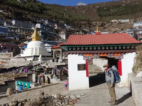
Namche Bazaar Arrival (3,440 m)
Namche is the Sherpa capital with its cafes, equipment shops, and museums. Its amphitheater-shaped terrain offers spectacular mountain views, making it a good ending to the trek.
Everest Base Camp Trek without Lukla Flight | 16 days
To start with, the trekking distance from Lukla to Namche Bazaar is about 19 kilometers (12 miles). The distance would normally take two days to walk comfortably. The trail is not very long, but it entails considerable elevation gain.
Especially, the hike rises from 2,860 meters at Lukla to 3,440 meters at Namche. The total rise is about 580 meters. Ascending this requires moderate exertion, especially for inexperienced hikers. For this reason, most people break the trip into two days.
Actually, day one will see trekkers trek to Phakding (2,610 m), about 8 kilometers. The trail from Lukla to Phakding is very flat and by the river. Hence, it acclimatizes your legs for the up-slope ahead.
Likewise, day two, the trekking distance is about 11 kilometers from Phakding to Namche. This part is steep and has several switchbacks. The climb takes endurance but rewards you with a great view of the mountains.
Moreover, the trail condition from Phakding to Namche varies. It is well marked but rocky in some sections. Trekkers need good footwear to negotiate rocky and muddy paths. Furthermore, mule traffic causes congested and dusty conditions on some parts.
Moreover, the moderate length and elevation allow room for acclimatization breaks. The majority of the trekkers overnight at Namche Bazaar to acclimatize before going higher.
Lastly, the 19-kilometer trek from Lukla to Namche is within the ability of most trekkers. Proper pacing and resting make it easier. The trek provides breathtaking scenery and cultural interactions.
How Difficult is the Trek from Lukla to Namche?
Actually, Lukla to Namche is moderately challenging to walk. It pushes your endurance mainly due to the dramatic increase in elevation. The trail goes up nearly 580 meters in about 19 kilometers in two days. That equates to the slope being tiring.
Besides, the height increases from 2,860 meters at Lukla to 3,440 meters at Namche. This increase may cause minor altitude effects such as breathlessness and fatigue. Therefore, trekkers must go up slowly and take lots of water.
Likewise, the terrain from Lukla to Namche is rocky and bumpy in most areas. You have to be cautious about your footwork, especially during rainy months when the trails are slippery. Good trekking shoes with a good grip are a must.
Similarly, the mule traffic adds to the difficulty. Mules will every so often block a narrow trail or raise clouds of dust. You need to be watchful and have your wits about you when passing them.
Nevertheless, the hike offers easy acclimatization opportunities. The first day to Phakding is less demanding and gives your body time to acclimatize. Most trekker's feel improved on the second day after one night's sleep.
Besides, Namche Bazaar itself is at a reasonable elevation to rest. Trekkers usually spend an extra day here acclimatizing before climbing higher.
Overall, though the trek between Lukla and Namche requires moderate fitness and stamina, it is achievable for the majority of people. Eating the trail at a relaxed pace and resting enough makes the journey comfortable and satisfying.
Everest Base Camp Trek with Helicopter Fly Out 10 Days | 10 days
Trekking from Lukla to Namche Bazaar Elevation Ranges
To begin with, the elevation on the Lukla to Namche trail varies significantly. Lukla is 2,860 meters (9,383 feet) above sea level. Namche Bazaar is 3,440 meters (11,286 feet) above sea level. Therefore, hikers climb about 580 meters (1,903 feet) in elevation.
Throughout the trek, the trail passes over numerous salient points of altitude. Phakding is 2,610 meters (8,563 feet). This is a lower altitude village and a normal overnight stay location. From it, the trail climbs moderately to Namche.
Also, the entrance to Sagarmatha National Park, Monjo, is at around 2,835 meters (9,301 feet). Following this, the trail is more rugged and steeper.
The trail's highest point before Namche is roughly 3,400 meters (11,154 feet). This is near the famous suspension bridge, Hillary Bridge, crossing the Dudh Koshi River. The bridge is roughly 200 meters from Namche Bazaar.
In addition, Namche has stunning vistas of several peaks. Everest (8,848 m), Lhotse (8,516 m), and Ama Dablam (6,812 m) dominate the horizon. These mountains are thousands of meters above the trail.
Briefly, the altitude increase from Lukla to Namche is moderate and it 580 meters. It requires good acclimatization for not falling ill with altitude. However, gradual ascent enables most trekkers to acclimatize well.
How is the Trail from Lukla to Namche?
Indeed, the trail from Lukla to Namche is scenic, varied, and bustling. It is mostly along the Dudh Koshi River valley. The trail of day one is largely flat with some gentle ups and downs. The stretch goes through forest and Sherpa villages.
And then on day two from Phakding, the trail becomes much steeper. It climbs steeply up through mixed forest and scree trails. There are many switchbacks as you ascend to Namche. The steep sections challenge your fitness but are rewarded with phenomenal views.
Moreover, the trail from Lukla to Namche also features a number of suspension bridges. These provide exhilarating river crossings and photo opportunities. The Hillary Suspension Bridge is one such spectacle.
In addition, the trail is a combination of dirt, rock, suspension bridges and wooden stairs. At times, the trail gets narrow, particularly along villages. Mule traffic and narrow places at times are to be expected by trekkers.
Also, the trail goes through lively villages such as Phakding, Monjo, and Jorsalle. All of them have tea houses and resting places. The villages portray Sherpa hospitality and culture.
Additionally, the trek from Lukla to Namche enters Sagarmatha National Park near Monjo. From this point on, the landscape is more natural and protected. The vegetation here is dense, and you get flashes of Himalayan wildlife.
All in all, the Lukla to Namche trek is a well-conserved and engaging trail. It is ideal for newbies and advanced trekkers alike. The views changes and the cultural breaks make it a really unforgettable first step into the Everest region.
Do I Need Permit While Trekking from Lukla to Namche Bazaar?
Firstly, you require permits to hike from Lukla to Namche Bazaar. The Everest zone is a conservation area and thus hiking without them is illegal. You need two permits. The first is the Khumbu Pasang Lhamu Rural Municipality Permit. This is acquired in Lukla or Monjo and, for foreigners, costs NPR 3,000. Secondly, you will require the Sagarmatha National Park Entry Permit. This costs NPR 3,000 for foreigners and is acquired in Monjo or Kathmandu.
Also, the Sagarmatha National Park permit is needed since the route enters the park at Monjo (2,835 m). This UNESCO World Heritage Site protects vulnerable species like the snow leopard and Himalayan tahr. It also protects the unique Sherpa culture and the stunning scenery of Everest (8,848 m), Lhotse (8,516 m), and Ama Dablam (6,812 m).
Likewise, the Khumbu Rural Municipality Permit helps fund local projects and infrastructure in the community. The income is utilized for the maintenance of trails, bridges, and waste management systems. Without this permit, you may be fined or stopped at checkposts.
The Khumbu Pasang Lhamu Rural Municipality Permit is a mandatory trekking permit for the Everest Base Camp Trek. Issued by the local municipality, it helps support trail maintenance, tourism management, and community development throughout the Khumbu region.
Moreover, the permit system also encourages responsible tourism. It helps control trekking numbers and reduces environmental degradation. Permits are often checked at Jorsalle (2,740 m) and Namche Bazaar (3,440 m) by authorities.
Briefly, both permits are necessary for trekking from Lukla to Namche. Getting them ahead of time saves you delays and offers a smooth trip. The permits directly benefit the preservation of the Everest region for future trekkers.
Which Villages Do I Pass Through While Trekking from Lukla to Namche?
For one, the trek between Lukla (2,860 m) and Namche Bazaar (3,440 m) passes through several quaint villages. All offer cultural richness, natural scenery, and rest stops. The first large village is Chheplung (2,700 m) with Mani walls and views of Kusum Kanguru (6,367 m). Soon after, you pass through Thado Koshi(2,580 m) with a river suspension bridge.
Also, Ghat (2,530 m) and Phakding (2,610 m) are beautiful settlements with prayer flags and vibrant-colored stupas. It's a spiritual atmosphere for trekkers. Phakding is a popular overnighting place. It contains many lodges, bakeries, and river views.
Similarly, the trail from Lukla to Namche continues through Toktok (2,760 m) and Bengkar (2,630 m). These villages are surrounded by forests and waterfalls. Then you reach Monjo (2,835 m), the gate of Sagarmatha National Park. Here, trekkers register permits before moving forward.
Similarly, Jorsalle (2,740 m) is the last village before ascending up to Namche. It has a few tea houses and a serene riverbank.
Collectively, all the villages along the Lukla to Namche trail add to the trek's charm. They provide rest, food, and glimpses of Sherpa culture. The changing scenery and warm hospitality make the trek to Namche unforgettable.
Where Is the Entrance of Sagarmatha National Park?
To begin with, the gate to Sagarmatha National Park is in Monjo, a small Sherpa village at an altitude of 2,835 meters (9,301 feet). This place is about 9 kilometers from Lukla and 3 kilometers shy of Jorsalle. Trekkers must stop here to register and buy or show their park permits.
Moreover, the Sagarmatha National park covers 1,148 square kilometers of Himalayan terrain. The park includes the world's tallest mountains such as Everest (8,848 m), Lhotse (8,516 m), and Nuptse (7,861 m). The entrance of the park is structured with traditional Mani walls, prayer wheels, and a small information center.
Similarly, Monjo's position makes it an appropriate checkpoint. Trekkers who go up from Lukla arrive here on the first day. Permit fees for foreigners are NPR 3,000, and it supports conservation and community development initiatives.
Apart from that, Sagarmatha National Park is also a UNESCO World Heritage Site. It protects endangered wildlife, alpine vegetation, and the cultural heritage of the Sherpa people. Information about park rules and safety is provided by park rangers at the gate.
Lastly, the Monjo entrance is the official gateway of the Everest region and Sagarmatha National Park. It marks the start of a protected landscape that integrates natural beauty and cultural significance.
What Is the Most Difficult Section While Trekking from Lukla to Namche?
To begin with, the steepest segment is the hill ascent from Jorsalle (2,740 m) to Namche Bazaar (3,440 m) while trekking from Lukla to Namche. Also, the people can call it like Hillary Bridge to Namche Bazaar, more specifically. The length is approximately 3.5 kilometers but there is a rise of around 700 meters of altitude. The ascent starts right after the famous Hillary Suspension Bridge at 3,250 meters. The ascent is unrelenting with many switchbacks ascending steeply.
In addition, the altitude gain makes breathing harder, especially for inexperienced trekkers. The reduced oxygen level at over 3,000 meters causes shortness of breath and tiredness. Pacing and resting therefore become inevitable.
Moreover, the path from Jorsalle to Namche is equally rocky and uneven in many places as well. The terrain requires cautious placement of feet. If it rains, the path is slippery, making it even more challenging.
Additionally, the part of the trail provides little flat ground. The sharp incline pushes both stamina and mental limits. Most trekkers experience it as difficult but rewarding when Namche Bazaar is finally reached.
In summary, although this part from Jorsalle to Namche is challenging, preparation and consistent pacing render it feasible. The reward is arriving at the colorful center of the Everest region.
Does Mule Traffic Disrupt While Trekking from Lukla to Namche?
In fact, mule traffic is not unusual on the Lukla to Namche route. Mules carry items like food, building materials, and supplies to isolated villages. Mules are usually seen in herds, escorted by local handlers.
Moreover, mule presence holds up your trekking from Lukla to Namche via Phakding. Along narrow paths, the mules compel trekkers to give way to them. Delays sometimes occur, especially in congested areas along villages like Phakding (2,610 m) or Monjo (2,835 m).
In the same way, mule trains raise dust on dry days while climbging from Phakding to Namche. It can be painful, so a scarf or buff comes in handy. Trekkers are able to hear their bells from a distance, allowing them to prepare to overtake.
Pack mules are a vital part of life in the Everest region, transporting food, fuel, and supplies to remote mountain villages. Trekkers may occasionally need to step aside and wait for mule caravans to pass.
But mule traffic also has a cultural aspect. It is the old way of moving goods in the Everest region. Without them, resupply to remote areas would be very challenging.
In conclusion, while mule traffic might create some minor disruptions, it's part of the trail experience.
Where Should I Have Lunch While Trekking from Lukla to Namche?
Above all else, lunch during trekking helps with energy levels. The Lukla (2,860 m) to Namche (3,440 m) trek typically takes 6–8 hours. Without lunch, drowsiness sets in quickly.
Besides, the majority of trekkers take their lunch at Jorsalle (2,740 m) or Toktok (2,760 m). The towns have tea houses where they offer Dal Bhat, noodles, soups, and tea. A hot meal brings back energy and acclimatizes the body to the altitude.
Similarly, lunch breaks offer a chance to relax muscles. It also offers you a chance to rehydrate and adjust gear. Spending time over a meal in a relaxing environment helps digest and boost stamina.
Moreover, skipping lunch can lead to low blood sugar and dizziness. This is dangerous during steep rises like Jorsalle to Namche.
In short, lunch is not just food; it is a strategic rest point. It makes the trekking day safer and more enjoyable.
Where Is the Best Night Stay While Trekking from Lukla to Namche?
Actually, the best overnight stay for the majority of trekkers while trekking from Lukla to Namche is Phakding (2,610 m). It is 8 kilometers away from Lukla and there are many tea houses. It lies on the Dudh Koshi River and it is a peaceful place.
Also, overnight accommodation in Phakding gives progressive acclimatization. Accommodation at a lower altitude than in Lukla helps the body acclimatize. This prevents initial altitude problems.
Phakding, too, has the different types of lodges with private rooms, hot showers, and restaurants. They all offer views of nearby mountains like Kusum Kanguru (6,367 m).
Also, a few travelers also use Monjo (2,835 m) for an overnight stay while trekking from Lukla to Namche. It is closer to Namche and shortens tomorrow's climb.
To sum up, Phakding is ideal for comfort, acclimatization, and river views for overnight stay during the trek from Lukla to Namche.
Can I Trek Lukla to Namche in a Single Day?
Technically, it is possible to trek to Namche from Lukla in a single day. It is about 19 kilometers with a net elevation of 580 meters. However, the climb from Jorsalle to Namche is a strenuous uphill physically. Therefore, people break the trek from Lukla to Namche in two days: overnight stay at Phakding and then trek to Namche.
Moreover, trekking within a day offers less time for acclimatization. Sudden climbing increases the probability of altitude sickness. Most trekking itineraries recommend dividing the journey into two days.
Likewise, an early departure is required if you want to attempt within one day. The trek can be 8–10 hours, depending on pace and breaks.
Also, daylight and weather must be considered. Afternoon cloud and wind can complicate the final climb.
Finally, treks from Lukla to Namche one day are suitable for experienced, well-acclimatized hikers but not for beginners.
Overall, the Lukla to Namche Bazaar trek has adventure, culture, and Himalayan scenery. It starts at 2,860 meters in Lukla and drops down through scenic Sherpa villages, across thrilling suspension bridges, and into Sagarmatha National Park's conservation areas. Along the way, there are constant pleasures: blooming rhododendrons, far-off views of Everest and Ama Dablam.
Moreover, the climb from Jorsalle up to Namche challenges your stamina but rewards you with breathtaking views and Namche Bazaar's hospitality at 3,440 meters. From cultural encounters to landscape natural beauty, to the sense of achievement, this trek offers a lasting perspective into the Everest region.
FAQS:
1. What is the distance of Trekking from Lukla to Namche? The distance of Trekking from Lukla to Namche is 19 kilometers and it takes two days to complete. You start at Lukla which is 2,860m high. Then you reach Namche Bazaar which is 3,440m high. So, the elevation gain is 580m. The route's very scenic and it follows the Dudh Koshi River. You will see Sherpa villages along the way.
2. How difficult is Trekking from Lukla to Namche? Trekking from Lukla to Namche is moderately difficult. This is because you have to climb 580m. There are some steep parts. The first day is easy as you walk to Phakding. The second day is harder as you have to climb a lot and cross the Hillary Bridge. If you are fit and walk at a pace you will be okay.
3. What are the elevation ranges in Trekking from Lukla to Namche? The elevation range for Trekking from Lukla to Namche starts at 2,860m in Lukla. Ends at 3,440m in Namche Bazaar. So, the net gain is 580m. You will pass through Phakding which's 2,610m high and Monjo which is 2,835m high. The climb is gradual which is good for your body to get used to the altitude.
4. How is the trail during Trekking from Lukla to Namche? The trail for Trekking from Lukla to Namche is varied. On the day you walk on gentle paths along the river. On the day you climb steep paths through the forest. You have to cross suspension bridges including the Hillary Bridge. The views of the mountains are stunning. You will see rhododendron and pine trees.
5. Do I need permits for Trekking from Lukla to Namche? Yes, you need permits for Trekking from Lukla to Namche. You have to get the Khumbu Pasang Lhamu Rural Municipality Permit and the Sagarmatha National Park Entry Permit. You can get these permits in Lukla or Monjo. These permits help protect the environment and the local people.
6. Which villages do I pass in Trekking from Lukla to Namche? When you do the Trekking from Lukla to Namche you pass through nice Sherpa villages. These villages are Chheplung, Phakding, Toktok, Bengkar, Monjo and Jorsalle. In these villages you can see the culture of the people and you can stay in tea houses. The people are very friendly and welcoming.
7. Where is the entrance of Sagarmatha National Park in Trekking from Lukla to Namche? The entrance of Sagarmatha National Park for Trekking from Lukla to Namche is in Monjo village. Here you have to show your permits before you can continue. This national park is a UNESCO site. It helps protect the environment and the local culture.
8. What is the most difficult section in Trekking from Lukla to Namche? The most difficult part of Trekking from Lukla to Namche is the climb after the Hillary Suspension Bridge to Namche Bazaar. This part is very steep. It can be tiring. The views of the mountains are very beautiful and it makes the hard work worth it.
9. Does mule traffic disrupt Trekking from Lukla to Namche? Yes, mule traffic can disrupt Trekking from Lukla to Namche. The paths are narrow. The mules can kick up a lot of dust. You have to be careful and stay out of the way of the mules. This is especially important near the villages.
10. Where should I have lunch during Trekking from Lukla to Namche? For lunch during Trekking from Lukla to Namche you should stop in Phakding or Monjo. These places have tea houses where you can eat and rest. The food is delicious. You can see the river or the mountains while you eat.
11. Where is the best night stay for Trekking from Lukla to Namche? The best place to stay for the night during Trekking from Lukla to Namche is Phakding. This place is very peaceful. It is by the river. The tea houses are comfortable. The food is good. Staying here helps you get used to the altitude.
12. Can I complete Trekking from Lukla to Namche in a single day? Yes, it is possible to complete Trekking from Lukla to Namche in one day. It is not a good idea. It is better to take two days and stay in Phakding for the night. This helps you get used to the altitude and you can enjoy the scenery more.
13. What are the highlights of Trekking from Lukla to Namche? The highlights of Trekking from Lukla to Namche include crossing the Hillary Suspension Bridge seeing the Sherpa villages and walking along the Dudh Koshi River. You also get to see the Sagarmatha National Park. You can see the mountains including Everest and Ama Dablam.
14. What should I pack for Trekking from Lukla to Namche? For Trekking from Lukla to Namche you should pack trekking boots, trekking poles and warm clothes. You should also bring a rain jacket, a water bottle, sunscreen and a hat. It is an idea to bring snacks and a small backpack.
15. Is acclimatization important in Trekking from Lukla to Namche? Yes, acclimatization is very important for Trekking from Lukla to Namche. You have to climb 580m. This can be hard for your body. You should walk slowly. Stay in Phakding for the night. This helps your body get used to the altitude.
16. What is the best time for Trekking from Lukla to Namche? The best time for Trekking from Lukla to Namche is in the spring or autumn. The weather is good. The views are clear. The trails are not too muddy. The rhododendron trees are in bloom.
17. Do I need a guide for Trekking from Lukla to Namche? You do not need a guide for Trekking from Lukla to Namche. The trail is well marked. It is easy to follow. Having a guide can be helpful. They can tell you about the culture and the history of the place.
18. What currency and facilities are available in Namche Bazaar after Trekking from Lukla to Namche? In Namche Bazaar you can find ATMs, shops and bakeries. You can also get Wi-Fi. This is a place to rest and stock up on supplies before you continue your trek.
19. Are there altitude sickness risks in Trekking from Lukla to Namche? Yes, there is a risk of altitude sickness when you do the Trekking from Lukla to Namche. You have to climb to 3,440m. This can be hard for your body. You should drink a lot of water. Walk slowly. If you have any symptoms, you should rest and not continue.
20. What happens after Trekking from Lukla to Namche? After you complete the Trekking from Lukla to Namche you can rest in Namche Bazaar. Then you can continue to Tengboche, Dingboche or Everest Base Camp. This is the start of an adventure, in the Everest region.