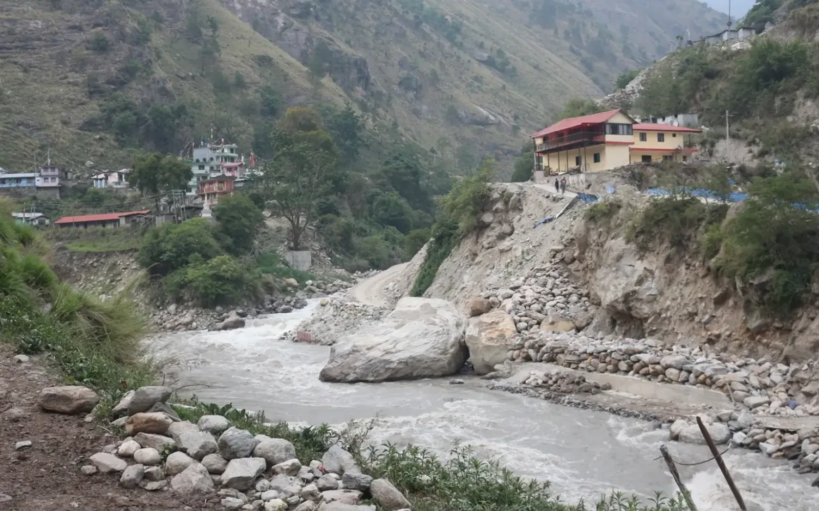
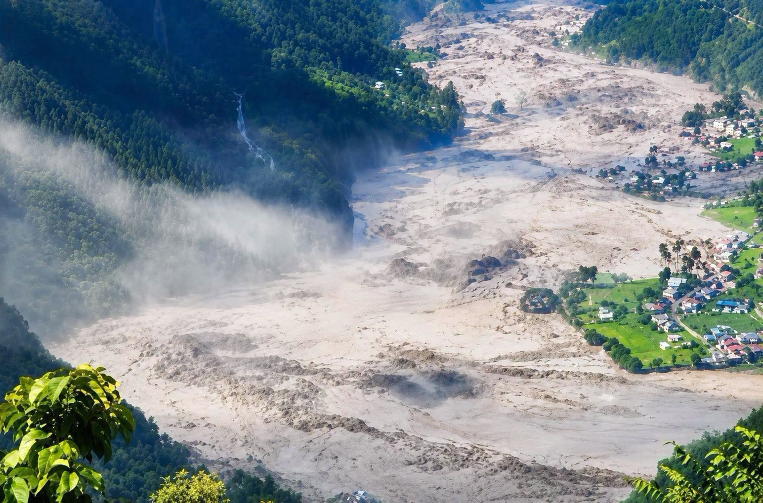
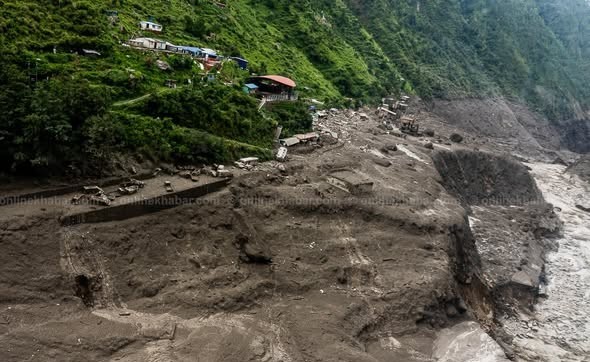
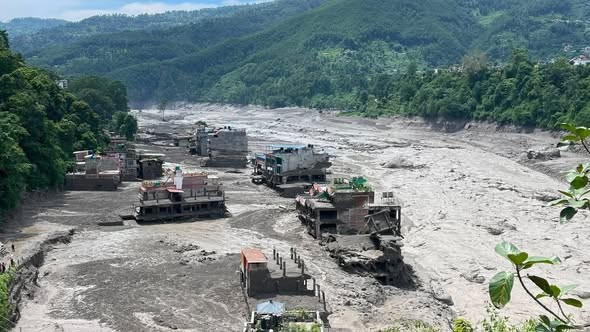
On August 26, 2026, there occurred a flash-flood disaster in Nepal that began in the Rasuwa District near the Nepal–Tibet border. The overflowing Bhote Koshi River submerged villages, roads, bridges, vehicles, and hydropower plants in the area of Timure and Syabrubesi and further downstream in the Trishuli River.
Meanwhile, the disaster was especially dangerous due to the suddenness of the flow that left little time for people to move away from the path of the water. Authorities warned downstream districts such as Rasuwa, Nuwakot, Dhading, Chitwan, and Gorkha to be prepared for the river overflow.
As of the latest report on the afternoon of 26 August, the causes of the disaster were still under investigation.
However, according to preliminary scientific analysis, it was either triggered by an ice avalanche that blocked the Lhende River, after which the water rushed back downstream and merged with the Bhote Koshi River, or a glacial lake outburst.
To confirm the suspicions, authorities have launched a scientific expedition, so the final conclusion may be different from the preliminary ones.
Moreover, the flood not only triggered landslides and infrastructure damage but also the destruction of hydropower plants.
Specifically, according to the Department of Roads, about 42 km of the road connecting Betrawati with the Rasuwagadhi border checkpoint was blocked, while the Nepal Electricity Authority reported significant damage to hydropower and transmission infrastructure.
The flood that occurred on 26 August,2026 is believed to have begun as a Himalayan-type flash flood and not a typical river flood that occurs due to prolonged rainfall.
The most plausible scenario suggests that :
According to a preliminary analysis published by The Kathmandu Post , an ice avalanche initiated the flow that blocked the Lhende River and caused the water to accumulate. Scientists are also considering the possibility of a glacial lake outburst as a reason for the flood.
| Cause | Effect |
|---|---|
| sudden blockage of the river upstream | water accumulation |
| bursting of the dam or ice block | a devastating flood surge |
| steep slopes of the Himalayas | fast flow of water downstream the river |
| narrow valleys | water inrush into the valley |
| settlements located next to the river | destruction of houses and infrastructure |
| roads and bridges in the valleys | obstruction of traffic routes |
| hydropower plants | damage to energy facilitie |
| monsoon season | increased risks of such disaster |
In addition to the fact that the flood was sudden and thus unpredictable, the main reason for the devastating effect was the location of settlements and infrastructure in the river valleys.
When the river was blocked upstream, water began to accumulate, but this was not visible to the people downstream. The situation was aggravated by the steep slopes of the mountains, within which narrow valleys turned the floodwater into a devastating surge.
Here, it is difficult to estimate in advance how far the surge of water rushing down mountain slopes will go, which is why such disasters are especially dangerous.
In addition, although the monsoon rains also intensified the situation, they were not the cause of the disaster, as it began as a typical Himalayan-type flash flood.
Moreover, the flood of 26 August,2026 is another reminder of the vulnerability of Nepal’s Himalayan valleys to the dangers of glacial activity, landslides, ice avalanches, and flash floods during the monsoon season.
Yes, the Kathmandu–Syabrubesi route is currently affected by the August 26 flash flood and associated landslide and erosion risks.
The situation is rapidly developing: on August 26, a sudden and massive flood entered the Bhote Koshi River from the Tibetan side and severely affected Timure and Syabrubesi in Rasuwa.
Due to the danger to travelers and road infrastructure, Kathmandu Valley Traffic Police suspended public vehicles heading toward Rasuwa, Nuwakot, Dhading and other affected districts.
There have also been serious monsoon-related problems on the Pasang Lhamu corridor before today's flood - landslides had damaged several sections between Betrawati and Rasuwagadhi, including areas around Ramche, Brabal, Lingling and Tatopani.
More importantly, authorities reported that erosion had washed away the roadbed at Khalte - completely cutting vehicular access toward Syabrubesi on a section of the wider Rasuwa road network.
| Item | August 26, 2026 situation |
|---|---|
| Kathmandu → Syabrubesi | Travel currently restricted |
| Pasang Lhamu Highway | Affected |
| Syabrubesi | Seriously affected by flooding |
| Timure | Seriously affected |
| Landslide risk | High |
| Flood risk | High |
| Public vehicles from Kathmandu | Halted toward affected areas |
| Langtang road access | Not currently normal |
Here, the Nepal Tourism Board has specifically advised tourists to postpone travel to flood-affected areas, including the Galchhi–Nuwakot–Rasuwa–Syabrubesi corridor, until road and safety conditions improve.
If planning a Langtang Valley Trek, do not assume the normal 7–9-hour Kathmandu–Syabrubesi drive is currently operating.
Most importantly, the situation needs to be reassessed after authorities inspect bridges, road sections, landslide zones and flood damage - a road may be technically open in one section but another section may be impassable.
Syabrubesi has been significantly affected by the August 26 flood and the situation is a developing emergency.
Here, the flood caused substantial damage in Syabrubesi and Timure, with reports of damage to markets, infrastructure and hydropower facilities - authorities described the flood as unusually large and sudden.
However, the floods effected in riverside area but the upper(trekking) part is still safe to stay overnight during Langtang Valley Trek.
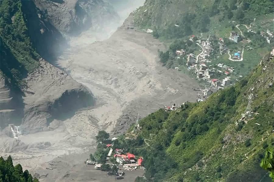
Reuters Nepal reported that the flood destroyed or damaged roads, bridges, houses and hydropower infrastructure in the Rasuwa area - rescue operations were also difficult due to the high water levels and damaged infrastructure.
Here, the most important point for travelers is that Syabrubesi should currently be considered a flood-affected area, rather than simply a temporarily delayed trekking destination.
| Situation | Current assessment |
|---|---|
| Flood impact | Severe |
| Roads | Damaged/affected |
| Bridges | Some infrastructure damaged |
| Local infrastructure | Significant damage reported |
| Hydropower facilities | Major damage reported |
| Kathmandu road access | Restricted |
| Trekking access | Not currently normal |
| Tourist movement | Postpone non-essential travel |
| Situation | Still developing |
Likewise, the Nepal Tourism Board has asked tourists already in affected areas to remain in safe locations, avoid rivers and riverbanks, avoid crossing flooded roads or streams and follow instructions from local authorities and security agencies. It has also advised travelers planning trips to the affected corridor to postpone them until conditions are restored.
What does this mean for the Langtang Trek?
For now:
In short: Syabrubesi has suffered serious flood damage and the Kathmandu–Syabrubesi road corridor is currently unsafe/restricted. The situation is still evolving on August 26, 2026, so travelers should wait for an official road-clearance update before attempting the journey.
Yes, the Langtang trekking region would have been indirectly impacted and the access route to Syabrubesi is currently heavily disrupted. However, as of the news today, there is not enough information to confirm that the Langtang Valley trekking trail has been destroyed or made unsafe beyond reaching Kyanjin Gompa.
Actually, the devastating flash flood on August 26 impacted the Rasuwa region, particularly the area around Syabrubesi and Timure, located along the Bhote Koshi river system. There are confirmed reports of damage to settlements, infrastructure and transport routes across the district. Syabrubesi is the main entry point for the Langtang Valley Trek via road access, and damage in the area directly impacts trekkers.
Here, the main difference at this time is between trail impact and access impact. The news reports confirm extensive damage along the lower Rasuwa road and river corridor, but do not include a full engineering assessment of the condition of the entire Langtang Valley trail from Syabrubesi to Kyanjin Gompa. But, as there is no flood in Langtang river, the trail from Langtang Hydropwer to Lama Hotel and Kyanjing is still safe.
| Area | Description | Damage/Situation |
|---|---|---|
| Kathmandu → Syabrubesi road | Main road connection to Langtang Valley trekking region | Seriously affected |
| Syabrubesi | Primary access point for Langtang Valley Trek | Flood-affected |
| Lower Langtang access | Trail access route from Syabrubesi | Disrupted |
| Syabrubesi → Langtang Village trail | Trekking trail segment | Partly affected at lower area- Higher area is safe |
| Langtang Village → Kyanjin Gompa | Trekking trail segment | Not affected- full-damage assessment yet |
| Kyanjin Gompa | Upper end of Langtang Valley Trek | Not affected confirmed |
| Trekking today | General safety advisory | Not recommended until full assessment |
Here, the Department of Hydrology and Meteorology currently has active flood warnings and monitoring systems, and authorities are working on rescue and damage-assessment operations.
Therefore, please do not mistake the statement "Langtang Valley is affected" for "the entire Langtang trail has been washed away". The confirmed direct impact is on the Syabrubesi access corridor and lower Rasuwa infrastructure.
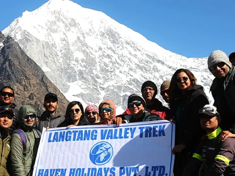
Right now, I would not say that the Langtang Valley Trek is fully safe or officially cleared for trekking. If you want, you can check the alternative route to Langtang Valley if it is safe. The disaster occurred only today and authorities are continuing rescue operations and damage assessments.
Meanwhile, the flood was extremely severe. There are reports that Syabrubesi was one of the affected settlements, and that roads, bridges and infrastructure were impacted. Helicopters have also had difficulty landing in the area due to the situation.
Likewise, another important issue is secondary landslides and unstable slopes – after flood waters recede, trekking trails can still be unsafe due to damaged bridges, retaining walls, river crossings and trail sections.
| Safety factor | Status |
|---|---|
| Syabrubesi access | Unsafe/disrupted |
| River crossings | High caution required |
| Landslide risk | Potentially high |
| Bridges | Need inspection |
| Lower trail | Needs assessment |
| Upper Langtang trail | Not Affected |
| Kyanjin Gompa route | Not affected |
| Independent trekking | Not advisable immediately |
| Organized trek | Wait for official clearance |
No, not immediately following the August 26, 2026 disaster.
Even if segments of the trail appear to be in good condition, the road from Kathmandu to Syabrubesi continues to be the primary concern. Even more importantly, trail condition assessments are not always consistent following a major flood.
Most importantly, prior to resuming Langtang trekking, the following should be verified by authorities and local trekking operators:
In conclusion, the current disaster has also impacted infrastructure in the wider Rasuwa area, including hydropower projects – this highlights the scale of the event.
As of August 26, 2026, the Langtang Valley Trek should be regarded as a temporarily disrupted route rather than a safe option for normal trekking. The confirmed significant damage is around Syabrubesi and access corridor, with a complete assessment of the upper Langtang trekking trail still pending.
For those planning to trek in the coming days, it is recommended to wait for an official update regarding road and trail clearance rather than following pre-flood itineraries. This is especially relevant given the continued active flood monitoring and warnings from the Department of Hydrology and Meteorology.
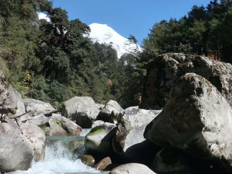
As of August 26, 2026, I do not believe that it would be safe to continue with the Langtang Valley trek at this time. The flash flood of 2026 has caused serious damage to Syabrubesi and Timure, Rasuwa. The road, bridges, houses and various other structures have been washed away or damaged. Search and rescue operations continue.
Now, an important clarification is needed. As of right now, there is no verified information that the Langtang Valley trekking trail from Syabrubesi to Kyanjin Gompa is completely destroyed. The flash flood damage appears to be focused around the lower Rasuwa corridor and Syabrubesi, the main gateway to the Langtang Valley Trek.
Here, this means that the danger zone is not simply the flood waters. Potential risks such as landslides, damaged bridges, riverbank erosion, trail erosion and further monsoon rains could create further obstacles. Nepal’s Department of Hydrology and Meteorology continues to monitor potential flooding.
| Safety factor | Current situation |
|---|---|
| Syabrubesi | Severely affected |
| Kathmandu - Syabrubesi road | Affected/disrupted/ only some part not all |
| Lower Langtang | Access requires assessment |
| Syabrubesi to Langtang Village trail | Lower Part affected |
| Langtang Village to Kyanjin trail | Not Affected |
| Landslide risk | Potentially high |
| River crossings | Require inspection |
| Normal trekking | Not recommended immediately |
Therefore, I recommend that trekkers wait for road and trail clearance before starting the Langtang trek.
Yes, the August 26 flood has affected the Langtang Valley Trekking trail, but it would be premature to say that the entire trek is destroyed. While the flash flood damaged Syabrubesi and the surrounding road infrastructure, it is not confirmed that the entire trail from Kathmandu to Langtang Valley has been affected.
Meanwhile, the flash flood of August 26 impacted the Bhote Koshi River system and Rasuwa. Local reports suggest that homes, roads, bridges, vehicles and hydropower facilities have been swept away or damaged by the flood.
This means that, while the flood has impacted the trekking gateway, we cannot say that every part of the trail has been damaged.
Consequently, it would be inaccurate to say “the entire Langtang Valley Trek is destroyed,” but it would also be unsafe to say “the trek is completely safe.”
In summary, the most accurate assessment on August 26 is that the Langtang trekking route is affected and should be considered temporarily disrupted until authorities and local trekking professionals confirm road and trail conditions.
The August 26 disaster is a flash-flood emergency in Rasuwa, and the situation continues to evolve. The most immediate concern is the severely affected Syabrubesi gateway and the associated road and river infrastructure. Search and rescue operations are ongoing, and the full extent of the damage has not yet been assessed.
Here, that is not to say that the Langtang Valley will not soon be safe for trekkers. Once the floodwaters recede, authorities can inspect the roads, bridges, trails, river crossings, lodges and communication infrastructure. If these facilities are confirmed as safe, the trek can gradually reopen.
| Recommendation | Status |
|---|---|
| Travel to Syabrubesi immediately | ❌ Avoid |
| Start Langtang Trek independently | ❌ Not recommended |
| Cross damaged bridges/roads | ❌ Never |
| Follow local authority instructions | ✅ Essential |
| Check DHM warnings | ✅ Essential |
| Contact local trekking agency | ✅ Recommended |
| Wait for trail inspection | ✅ Strongly recommended |
| Resume after official clearance | ✅ Possible |
Here, the Department of Hydrology and Meteorology maintains real-time hydrological monitoring and flood-warning services, including warnings for potentially dangerous conditions.
The Langtang Valley Trek has been affected by the August 26, 2026 flood, primarily because Syabrubesi and the access corridor have been seriously damaged.
At the same time, however, there is not sufficient verified information to say that the entire Langtang Valley trail is destroyed.
For travelers considering the trek immediately after August 26, the safest option is to postpone departure until the Kathmandu-Syabrubesi road and the trekking trail have been officially assessed and cleared.
Once authorities confirm safe access, Langtang can potentially reopen as a trekking destination, but until then, safety should take priority over maintaining a fixed itinerary.
1. Has the August 26, 2026 flood affected the Langtang Valley Trail?
Yes, the Langtang Valley Trail has been impacted in terms of accessibility by the flood on August 26, 2026. The lower region of the trek had been severely damaged by the flood, particularly around Syabrubesi. However, there has not yet been enough information to declare that the entire Langtang Valley Trek is destroyed.
2. Is Langtang Valley Trek open after the August 26, 2026 flood?
It is currently not recommended to assume that the Langtang Valley Trek is open for now without a recent trail inspection. The trail’s access point in Syabrubesi has been severely affected by the flood on August 26. Authorities are still conducting rescue and damage assessment operations in the region. It is best to confirm the trail and road conditions in the region before trekking.
3. Was Syabrubesi affected by the August 26, 2026 Nepal flood?
Yes, Syabrubesi has been affected by the flood that occurred on August 26, 2026 Nepal. This region in Rasuwa had been reported to be severely damaged alongside other nearby regions affected by the Bhotekoshi flood. Since Syabrubesi is generally the usual access point to the Langtang Valley Trek, this has implications on local transportation and trekking tour operations.
4. Can I start the Langtang Valley Trek from Syabrubesi after the flood?
It is currently not recommended to start the Langtang Valley Trek from Syabrubesi due to the significant impact of the flood on road infrastructure in the region. Authorities have recommended avoiding travel on the Nuwakot-Rasuwa-Syabrubesi route. Road conditions, bridge sites, and trail stability must be inspected before starting the trek.
5. Has the flood damaged the upper Langtang Valley trekking trail?
The flood on August 26 has severely damaged trail access points and structures in Syabrubesi and the Bhotekoshi region. However, there has not been enough information yet to confirm whether the upper trail regions beyond Syabrubesi have been damaged. A local trail inspection is still necessary before trekking.
6. Is the Langtang Valley Trek safe after the August 26, 2026 flood?
The Langtang Valley Trek must not be considered safe at least not immediately after the August 26 flood. It is well-known that such natural disasters pose a significant risk to mountainous trekking trails. Slopes and rocks along the trail may be unstable, and bridges may be damaged. It is best to acquire recent information regarding trail conditions before embarking on the trek.
7. Has the road to Langtang Valley been damaged by the August 26 flood?
Yes, the road to the Langtang Valley has been significantly damaged by the flood on August 26. Particularly in northern Rasuwa, road infrastructure has been severely impacted, disrupting local transportation. The Department of Roads has reported that approximately 42 km of road between Betrawati and Rasuwagadhi have been destroyed with several bridges washed away. Conditions on the road between Syabrubesi and the border are also being assessed.
8. Should I cancel my Langtang Valley Trek because of the August 26 flood?
It is not yet recommended to cancel the Langtang Valley Trek because of the flood on August 26, 2026. However, it is best to update yourselves with the latest trail conditions before trekking. While it is true that this disaster has significantly impacted transportation and trail access points in Syabrubesi, the entire trail region is still subject to inspection. It is good to consider flexible booking options if you are arranging your trip through agencies.
9. When will the Langtang Valley Trek reopen after the August 26, 2026 flood?
There has not been any definite information yet regarding when the Langtang Valley Trek will reopen to trekkers. Currently, local authorities are focusing on rescue and damage assessment operations in Rasuwa.
Actually, reopening of trekking access to the region will only be declared when road and trail conditions have been inspected and stabilized. It is best to rely on updates from local authorities rather than a projected reopening date.
10. What should trekkers do before visiting Langtang Valley after the flood, 2026?
Prior to visiting Langtang Valley, it is crucial to update yourselves with the latest trail conditions, road access and bridge sites, accommodation availability, and local authority announcements.
Likewise, it is also a good idea to get in touch with local trekking agencies to verify the status of the trail and surrounding infrastructure with enough time before your intended trek date. With the recent flood disaster, it is a great idea to be flexible with your itinerary until the trail has been confirmed safe and stable.
Updated:26/08/2026
Our travel experts are ready to assist you with any questions.
Send us a message.Have a question before you book? Send your enquiry below and our travel experts will get back with the required information.