[{"name":"Everest Base Camp Helicopter Tour","duration":"1","image_url":"https:\/\/www.havenholidaysnepal.com\/storage\/trip-galleries\/1\/thumb_6cd53005d75a86e373d31419d1b14d78.webp","offer_price":1195,"url":"https:\/\/www.havenholidaysnepal.com\/trips\/everest-base-camp-helicopter-tour"},{"name":"Everest Mountain Flight","duration":"1","image_url":"https:\/\/www.havenholidaysnepal.com\/storage\/trip-galleries\/4\/thumb_3b0b4f1d6f72b0ad224daf4752f2c6e0.jpg","offer_price":285,"url":"https:\/\/www.havenholidaysnepal.com\/trips\/everest-mountain-flight"},{"name":"Everest Short Trek","duration":"9","image_url":"https:\/\/www.havenholidaysnepal.com\/storage\/trip-galleries\/5\/thumb_BXPP3621.JPEG0.02033800 1727957098.webp","offer_price":995,"url":"https:\/\/www.havenholidaysnepal.com\/trips\/everest-short-trek"},{"name":"Gokyo Valley Trek","duration":"12","image_url":"https:\/\/www.havenholidaysnepal.com\/storage\/trip-galleries\/6\/thumb_10bc469b14731f23d3ce84a7092ad53f.jpg","offer_price":1195,"url":"https:\/\/www.havenholidaysnepal.com\/trips\/gokyo-valley-trek"},{"name":"15 days Annapurna Base Camp Trek","duration":"15","image_url":"https:\/\/www.havenholidaysnepal.com\/storage\/trip-galleries\/7\/thumb_87d1533bc45faf070990aef0579e4be4.jpg0.81855100 1728285496.webp","offer_price":785,"url":"https:\/\/www.havenholidaysnepal.com\/trips\/15-days-annapurna-base-camp-trek"},{"name":"Nepal Pilgrimage Tour","duration":"14","image_url":"https:\/\/www.havenholidaysnepal.com\/storage\/trip-galleries\/8\/thumb_02c3bcf2ad2e8a4c1703e90ae747b5f1.jpg","offer_price":1475,"url":"https:\/\/www.havenholidaysnepal.com\/trips\/nepal-pilgrimage-tour"},{"name":"UNESCO World Heritage Site Tour","duration":"10","image_url":"https:\/\/www.havenholidaysnepal.com\/storage\/trip-galleries\/9\/thumb_unesco-world-heritage-site-Lumbani-temple-buddhists-hindus-kathmandu-nepal0.36988600 17347617740.93089500 1737469667.webp","offer_price":715,"url":"https:\/\/www.havenholidaysnepal.com\/trips\/unesco-world-heritage-site-tour"},{"name":"Island Peak Climbing","duration":"16","image_url":"https:\/\/www.havenholidaysnepal.com\/storage\/trip-galleries\/11\/thumb_Island peak0.53947000 1734692503.webp","offer_price":2495,"url":"https:\/\/www.havenholidaysnepal.com\/trips\/island-peak-climbing"},{"name":"Upper Mustang Trek","duration":"18","image_url":"https:\/\/www.havenholidaysnepal.com\/storage\/trip-galleries\/12\/thumb_upper mustang 7 Oct-2024.jpg0.95398900 1728286166.webp","offer_price":2995,"url":"https:\/\/www.havenholidaysnepal.com\/trips\/upper-mustang-trek"},{"name":"Annapurna Circuit Trek","duration":"16","image_url":"https:\/\/www.havenholidaysnepal.com\/storage\/trip-galleries\/15\/thumb_tibetan-flags.jpg0.04843900 1728289138.webp","offer_price":985,"url":"https:\/\/www.havenholidaysnepal.com\/trips\/annapurna-circuit-trek"},{"name":"Gosainkunda Lake Trek","duration":"10","image_url":"https:\/\/www.havenholidaysnepal.com\/storage\/trip-galleries\/16\/thumb_5A8083B3-C007-41A8-853F-D0C37C97D235_1_105_c.jpeg0.52581200 1731845258.webp","offer_price":595,"url":"https:\/\/www.havenholidaysnepal.com\/trips\/gosainkunda-lake-trek"},{"name":"Zip-lining in Pokhara and Dhulikhel","duration":"1","image_url":"https:\/\/www.havenholidaysnepal.com\/storage\/trip-galleries\/18\/thumb_215f765e2ebc995dd5c800b4bfdbacc3.jpg","offer_price":82,"url":"https:\/\/www.havenholidaysnepal.com\/trips\/zip-lining-in-pokhara-and-dhulikhel"},{"name":"Annapurna Heli Tour","duration":"1","image_url":"https:\/\/www.havenholidaysnepal.com\/storage\/trip-galleries\/19\/thumb_d71a6bbb9fd4da8d1b567a5cdbdec85d.jpg","offer_price":555,"url":"https:\/\/www.havenholidaysnepal.com\/trips\/annapurna-heli-tour"},{"name":"Paragliding in Pokhara","duration":"1","image_url":"https:\/\/www.havenholidaysnepal.com\/storage\/trip-galleries\/20\/thumb_de788d2dd9726783431f882c007efae1.jpg","offer_price":65,"url":"https:\/\/www.havenholidaysnepal.com\/trips\/paragliding-in-pokhara"},{"name":"Ultra-Flight in Pokhara","duration":"1","image_url":"https:\/\/www.havenholidaysnepal.com\/storage\/trip-galleries\/21\/thumb_e27a9fb572a5c21611bb2a3c18e4b8f0.jpeg","offer_price":175,"url":"https:\/\/www.havenholidaysnepal.com\/trips\/ultra-flight-in-pokhara"},{"name":"Sarangkot Hiking","duration":"1","image_url":"https:\/\/www.havenholidaysnepal.com\/storage\/trip-galleries\/22\/thumb_100ef822fea19987166c6c1366215f15.jpg","offer_price":55,"url":"https:\/\/www.havenholidaysnepal.com\/trips\/sarangkot-hiking"},{"name":"Mera Peak Climbing","duration":"18","image_url":"https:\/\/www.havenholidaysnepal.com\/storage\/trip-galleries\/24\/thumb_d16ae3895f678cf26ffbf2455f541fb5.jpg0.31883400 1732617790.webp","offer_price":2475,"url":"https:\/\/www.havenholidaysnepal.com\/trips\/mera-peak-climbing"},{"name":"Lower Dolpo Trek","duration":"18","image_url":"https:\/\/www.havenholidaysnepal.com\/storage\/trip-galleries\/26\/thumb_Dolpo Galary - 1.JPG0.37725200 1727939952.webp","offer_price":2995,"url":"https:\/\/www.havenholidaysnepal.com\/trips\/lower-dolpo-trek"},{"name":"Nagarkot Sunrise\/Sunset Tour","duration":"1","image_url":"https:\/\/www.havenholidaysnepal.com\/storage\/trip-galleries\/27\/thumb_5147a5532644283a380f2e86f3857c13.jpg0.17748000 1728488108.webp","offer_price":30,"url":"https:\/\/www.havenholidaysnepal.com\/trips\/nagarkot-sunrise-sunset-tour"},{"name":"16 day Everest Base Camp Trek","duration":"16","image_url":"https:\/\/www.havenholidaysnepal.com\/storage\/trip-galleries\/28\/thumb_IMG_4311.JPG0.64984800 1727942213.webp","offer_price":1475,"url":"https:\/\/www.havenholidaysnepal.com\/trips\/16-day-everest-base-camp-trek"},{"name":"Ghorepani Poon Hill trek with Jungle Safari and Trishuli River Rafting -13 days","duration":"13","image_url":"https:\/\/www.havenholidaysnepal.com\/storage\/trip-galleries\/29\/thumb_Ghorepani Poon hill.jpg0.48460800 1728281439.webp","offer_price":795,"url":"https:\/\/www.havenholidaysnepal.com\/trips\/ghorepani-poon-hill-trek-with-jungle-safari-and-trishuli-river-rafting--13-days"},{"name":"Mardi Himal Trek","duration":"12","image_url":"https:\/\/www.havenholidaysnepal.com\/storage\/trip-galleries\/30\/thumb_s1.jpg0.62112600 1728200721.webp","offer_price":795,"url":"https:\/\/www.havenholidaysnepal.com\/trips\/mardi-himal-trek"},{"name":"Langtang Valley Trekking","duration":"10","image_url":"https:\/\/www.havenholidaysnepal.com\/storage\/trip-galleries\/31\/thumb_IMG_4702.JPG0.84916500 1727958504.webp","offer_price":685,"url":"https:\/\/www.havenholidaysnepal.com\/trips\/langtang-valley-trekking"},{"name":"Real Adventure Tour in Nepal","duration":"9","image_url":"https:\/\/www.havenholidaysnepal.com\/storage\/trip-galleries\/32\/thumb_ebd1b8cc78d90abe8b9003dd9a2f25bf.jpg0.82151300 1728213516.webp","offer_price":695,"url":"https:\/\/www.havenholidaysnepal.com\/trips\/real-adventure-tour-in-nepal"},{"name":"Luxury Tour in Nepal","duration":"10","image_url":"https:\/\/www.havenholidaysnepal.com\/storage\/trip-galleries\/33\/thumb_8574e61b252b18676b042caf30d830df.jpg","offer_price":1675,"url":"https:\/\/www.havenholidaysnepal.com\/trips\/luxury-tour-in-nepal"},{"name":"Luxury Everest Panorama Trek With EBC Heli Sightseeing","duration":"8","image_url":"https:\/\/www.havenholidaysnepal.com\/storage\/trip-galleries\/34\/thumb_URZL2397.JPEG0.01209600 1728027820.webp","offer_price":2575,"url":"https:\/\/www.havenholidaysnepal.com\/trips\/luxury-everest-panorama-trek-with-ebc-heli-sightseeing"},{"name":"13 day Everest Base Camp Trek with Helicopter","duration":"13","image_url":"https:\/\/www.havenholidaysnepal.com\/storage\/trip-galleries\/35\/thumb_IMG_4292.JPG0.70131500 1728029276.webp","offer_price":2095,"url":"https:\/\/www.havenholidaysnepal.com\/trips\/13-day-everest-base-camp-trek-with-helicopter"},{"name":"Manaslu Circuit Trek","duration":"16","image_url":"https:\/\/www.havenholidaysnepal.com\/storage\/trip-galleries\/36\/thumb_Mt Manaslu 03-Oct-2024.jpg0.65804900 1727938470.webp","offer_price":955,"url":"https:\/\/www.havenholidaysnepal.com\/trips\/manaslu-circuit-trek"},{"name":"Kanchenjunga Base Camp Trek","duration":"21","image_url":"https:\/\/www.havenholidaysnepal.com\/storage\/trip-galleries\/37\/thumb_Kanchanjunga Trek -!.jpg0.54744400 1727938497.webp","offer_price":2275,"url":"https:\/\/www.havenholidaysnepal.com\/trips\/kanchenjunga-base-camp-trek"},{"name":"Ganesh Himal and Sing-La Trek","duration":"18","image_url":"https:\/\/www.havenholidaysnepal.com\/storage\/trip-galleries\/38\/thumb_Ganesh Himal slider-1.jpg0.43764500 1727937722.webp","offer_price":2975,"url":"https:\/\/www.havenholidaysnepal.com\/trips\/ganesh-himal-and-sing-la-trek"},{"name":"Island Peak Climb with Everest Base Camp Trek","duration":"21","image_url":"https:\/\/www.havenholidaysnepal.com\/storage\/trip-galleries\/39\/thumb_2be428730fe83525bc85a010564f99de.jpg","offer_price":2750,"url":"https:\/\/www.havenholidaysnepal.com\/trips\/island-peak-climb-with-everest-base-camp-trek"},{"name":"Students' Adventure Tour in Nepal","duration":"12","image_url":"https:\/\/www.havenholidaysnepal.com\/storage\/trip-galleries\/41\/thumb_a926d22fbfe08cba271c41ac289b3fd2.jpg","offer_price":995,"url":"https:\/\/www.havenholidaysnepal.com\/trips\/students-adventure-tour-in-nepal"},{"name":"7 Day Poonhill Trek","duration":"7","image_url":"https:\/\/www.havenholidaysnepal.com\/storage\/trip-galleries\/42\/thumb_6196bd69036473293a2c24cc21ed57d7.jpg0.10880600 1728205378.webp","offer_price":555,"url":"https:\/\/www.havenholidaysnepal.com\/trips\/7-day-poonhill-trek"},{"name":"7 Days Annapurna Base Camp Trek","duration":"7","image_url":"https:\/\/www.havenholidaysnepal.com\/storage\/trip-galleries\/43\/thumb_IMG_2214.JPG0.08204900 1728202033.webp","offer_price":355,"url":"https:\/\/www.havenholidaysnepal.com\/trips\/7-days-annapurna-base-camp-trek"},{"name":"3 days Poonhill Trek","duration":"3","image_url":"https:\/\/www.havenholidaysnepal.com\/storage\/trip-galleries\/44\/thumb_Poon hill.jpg0.60816600 1731412954.webp","offer_price":165,"url":"https:\/\/www.havenholidaysnepal.com\/trips\/3-days-poonhill-trek"},{"name":"Poon Hill Luxury Trek with Chitwan-12 days","duration":"12","image_url":"https:\/\/www.havenholidaysnepal.com\/storage\/trip-galleries\/45\/thumb_Poom hill.jpg0.52074500 1730180532.webp","offer_price":1175,"url":"https:\/\/www.havenholidaysnepal.com\/trips\/poon-hill-luxury-trek-with-chitwan-12-days"},{"name":"Everest Luxury Trek-7 days","duration":"7","image_url":"https:\/\/www.havenholidaysnepal.com\/storage\/trip-galleries\/46\/thumb_ACRX9330.JPEG0.93236200 1728031275.webp","offer_price":1975,"url":"https:\/\/www.havenholidaysnepal.com\/trips\/everest-luxury-trek-7-days"},{"name":"Hindu Pilgrimage Tour in Nepal-10 days","duration":"10","image_url":"https:\/\/www.havenholidaysnepal.com\/storage\/trip-galleries\/47\/thumb_a94bf96a4d31decb419f6f828a3280d2.jpg","offer_price":995,"url":"https:\/\/www.havenholidaysnepal.com\/trips\/hindu-pilgrimage-tour-in-nepal-10-days"},{"name":"Everest Base Camp Short Trek-12 days","duration":"12","image_url":"https:\/\/www.havenholidaysnepal.com\/storage\/trip-galleries\/48\/thumb_IMG_4311.JPG0.52680100 1727945154.webp","offer_price":995,"url":"https:\/\/www.havenholidaysnepal.com\/trips\/everest-base-camp-short-trek-12-days"},{"name":"Everest Base Camp Hike 12 Days","duration":"12","image_url":"https:\/\/www.havenholidaysnepal.com\/storage\/trip-galleries\/49\/thumb_IMG_4260.JPG0.51729100 1728061234.webp","offer_price":1295,"url":"https:\/\/www.havenholidaysnepal.com\/trips\/everest-base-camp-hike-12-days"},{"name":"11 Days Everest Base Camp Trek","duration":"11","image_url":"https:\/\/www.havenholidaysnepal.com\/storage\/trip-galleries\/50\/thumb_IMG_4249.JPG0.21392500 1727946959.webp","offer_price":985,"url":"https:\/\/www.havenholidaysnepal.com\/trips\/11-days-everest-base-camp-trek"},{"name":"6 Days Annapurna Base Camp Trek","duration":"6","image_url":"https:\/\/www.havenholidaysnepal.com\/storage\/trip-galleries\/51\/thumb_6 days Abc.jpg0.58185400 1728200798.webp","offer_price":285,"url":"https:\/\/www.havenholidaysnepal.com\/trips\/6-days-annapurna-base-camp-trek"},{"name":"Annapurna Base Camp Trek","duration":"8","image_url":"https:\/\/www.havenholidaysnepal.com\/storage\/trip-galleries\/52\/thumb_IMG_2214.JPG0.29415700 1729487656.webp","offer_price":585,"url":"https:\/\/www.havenholidaysnepal.com\/trips\/annapurna-base-camp-trek"},{"name":"Everest Base Camp Trek with Helicopter Fly Out 10 Days","duration":"10","image_url":"https:\/\/www.havenholidaysnepal.com\/storage\/trip-galleries\/53\/thumb_IMG_4328.JPG0.52056600 1728058444.webp","offer_price":1875,"url":"https:\/\/www.havenholidaysnepal.com\/trips\/everest-base-camp-trek-with-helicopter-fly-out-10-days"},{"name":"Everest Base Camp Trek 14 Days","duration":"14","image_url":"https:\/\/www.havenholidaysnepal.com\/storage\/trip-galleries\/54\/thumb_Everest Base Camp Trek 14 days Oct 3 2024.JPG0.43202700 1727939745.webp","offer_price":1455,"url":"https:\/\/www.havenholidaysnepal.com\/trips\/everest-base-camp-trek-14-days"},{"name":"ABC Trek with Poonhill 11 Days","duration":"11","image_url":"https:\/\/www.havenholidaysnepal.com\/storage\/trip-galleries\/55\/thumb_ABC with fishtail.JPG0.21441100 1728277965.webp","offer_price":555,"url":"https:\/\/www.havenholidaysnepal.com\/trips\/abc-trek-with-poonhill-11-days"},{"name":"Muldai Hill Trek 9 Days","duration":"9","image_url":"https:\/\/www.havenholidaysnepal.com\/storage\/trip-galleries\/56\/thumb_7efee59f0a8c6817c8255bd2b9f3539d.jpeg0.19479300 1728213091.webp","offer_price":675,"url":"https:\/\/www.havenholidaysnepal.com\/trips\/muldai-hill-trek-9-days"},{"name":"Mardi Himal Trek 6 days","duration":"6","image_url":"https:\/\/www.havenholidaysnepal.com\/storage\/trip-galleries\/57\/thumb_slider 1.jpeg0.36909700 1728184981.webp","offer_price":590,"url":"https:\/\/www.havenholidaysnepal.com\/trips\/mardi-himal-trek-6-days"},{"name":"Mardi Himal Trek 7 days","duration":"7","image_url":"https:\/\/www.havenholidaysnepal.com\/storage\/trip-galleries\/58\/thumb_slider1.jpg0.61666600 1728206414.webp","offer_price":620,"url":"https:\/\/www.havenholidaysnepal.com\/trips\/mardi-himal-trek-7-days"},{"name":"Mardi Himal Trek 8 Days","duration":"8","image_url":"https:\/\/www.havenholidaysnepal.com\/storage\/trip-galleries\/59\/thumb_sli1.jpg0.38569100 1728206631.webp","offer_price":695,"url":"https:\/\/www.havenholidaysnepal.com\/trips\/mardi-himal-trek-8-days"},{"name":"14 Days Manaslu Trek","duration":"14","image_url":"https:\/\/www.havenholidaysnepal.com\/storage\/trip-galleries\/60\/thumb_sunrise-mt-manaslu-during-manaslu-circuit-larke-pass-trekking-himalaya-nepal (1)0.81855800 1738673284.webp","offer_price":885,"url":"https:\/\/www.havenholidaysnepal.com\/trips\/14-days-manaslu-trek"},{"name":"Dhampus-Sarangkot Trek with Chitwan 8 days","duration":"8","image_url":"https:\/\/www.havenholidaysnepal.com\/storage\/trip-galleries\/61\/thumb_Sarangkot Bhangyang.jpg0.75461400 1728210333.webp","offer_price":790,"url":"https:\/\/www.havenholidaysnepal.com\/trips\/dhampus-sarangkot-trek-with-chitwan-8-days"},{"name":"7 Days Golden Triangle Tour","duration":"7","image_url":"https:\/\/www.havenholidaysnepal.com\/storage\/trip-galleries\/62\/thumb_311ce1d117ee0ba75402a7c301bcdf830.73532400 1739179809.webp","offer_price":845,"url":"https:\/\/www.havenholidaysnepal.com\/trips\/7-days-golden-triangle-tour"},{"name":"Annapurna Circuit Trek 12 days","duration":"12","image_url":"https:\/\/www.havenholidaysnepal.com\/storage\/trip-galleries\/63\/thumb_IMG_20161024_092237.jpg0.57796600 1728289938.webp","offer_price":695,"url":"https:\/\/www.havenholidaysnepal.com\/trips\/annapurna-circuit-trek-12-days"},{"name":"Everest Base Camp Budget Trek 16 Days","duration":"16","image_url":"https:\/\/www.havenholidaysnepal.com\/storage\/trip-galleries\/64\/thumb_IMG_4423.JPG0.92579200 1728144669.webp","offer_price":958,"url":"https:\/\/www.havenholidaysnepal.com\/trips\/everest-base-camp-budget-trek-16-days"},{"name":"Poonhill Budget Trek 7 Days","duration":"7","image_url":"https:\/\/www.havenholidaysnepal.com\/storage\/trip-galleries\/65\/thumb_5be067852d0c5228d6f3155bc425c6b5.jpg","offer_price":395,"url":"https:\/\/www.havenholidaysnepal.com\/trips\/poonhill-budget-trek-7-days"},{"name":"Annapurna Base Camp Budget Trek 8 Days","duration":"8","image_url":"https:\/\/www.havenholidaysnepal.com\/storage\/trip-galleries\/66\/thumb_Pokhara.jpg0.16188000 1728212001.webp","offer_price":375,"url":"https:\/\/www.havenholidaysnepal.com\/trips\/annapurna-base-camp-budget-trek-8-days"},{"name":"The Real UNESCO Seven World Heritage Tour in Kathmandu 4 days","duration":"4","image_url":"https:\/\/www.havenholidaysnepal.com\/storage\/trip-galleries\/67\/thumb_Baudha Stupa.JPG0.63906900 1728201021.webp","offer_price":380,"url":"https:\/\/www.havenholidaysnepal.com\/trips\/the-real-unesco-seven-world-heritage-tour-in-kathmandu-4-days"},{"name":"Everest Base Camp Jeep Ride with Helicopter Return","duration":"14","image_url":"https:\/\/www.havenholidaysnepal.com\/storage\/trip-galleries\/68\/thumb_788ee5b63a6efb6f3c3d048b4270daca.JPG","offer_price":1895,"url":"https:\/\/www.havenholidaysnepal.com\/trips\/everest-base-camp-jeep-ride-with-helicopter-return"},{"name":"Annapurna Base Camp Jeep Ride with Helicopter Return 7 days","duration":"7","image_url":"https:\/\/www.havenholidaysnepal.com\/storage\/trip-galleries\/69\/thumb_abc jeep.jpg0.10280600 1728204064.webp","offer_price":1455,"url":"https:\/\/www.havenholidaysnepal.com\/trips\/annapurna-base-camp-jeep-ride-with-helicopter-return-7-days"},{"name":"Everest Base Camp Trek","duration":"15","image_url":"https:\/\/www.havenholidaysnepal.com\/storage\/trip-galleries\/70\/thumb_Everest Base Camp Trek 3 oct- 2024.JPG0.58445300 1727941472.webp","offer_price":1575,"url":"https:\/\/www.havenholidaysnepal.com\/trips\/everest-base-camp-trek"},{"name":"7 UNESCO World Heritage Tour Kathmandu 2 days","duration":"2","image_url":"https:\/\/www.havenholidaysnepal.com\/storage\/trip-galleries\/72\/thumb_Bhaktipur 3.jpg0.05559600 1728201496.webp","offer_price":150,"url":"https:\/\/www.havenholidaysnepal.com\/trips\/7-unesco-world-heritage-tour-kathmandu-2-days"},{"name":"Day Tour to UNESCO Heritage Sites","duration":"1","image_url":"https:\/\/www.havenholidaysnepal.com\/storage\/trip-galleries\/73\/thumb_228A1018.jpg0.79892500 1728199793.webp","offer_price":55,"url":"https:\/\/www.havenholidaysnepal.com\/trips\/day-tour-to-unesco-heritage-sites"},{"name":"Golden Triangle Tour in Nepal","duration":"8","image_url":"https:\/\/www.havenholidaysnepal.com\/storage\/trip-galleries\/74\/thumb_f54139cf9100f00015ffe0400687e946.webp","offer_price":588,"url":"https:\/\/www.havenholidaysnepal.com\/trips\/golden-triangle-tour-in-nepal"},{"name":"Everest Base Camp Honeymoon Tour by Helicopter with Pokhara","duration":"7 days","image_url":"https:\/\/www.havenholidaysnepal.com\/storage\/trip-galleries\/76\/thumb_RJTL7517.JPEG0.40261600 1731499989.webp","offer_price":9999,"url":"https:\/\/www.havenholidaysnepal.com\/trips\/everest-base-camp-honeymoon-tour-by-helicopter-with-pokhara"},{"name":"Yoga and Meditation Retreat Tour in Nepal","duration":"10 days","image_url":"https:\/\/www.havenholidaysnepal.com\/storage\/trip-galleries\/77\/thumb_decf8e33-6617-4400-9df0-63bf75509adf.JPG0.51948300 1731574810.webp","offer_price":2575,"url":"https:\/\/www.havenholidaysnepal.com\/trips\/yoga-and-meditation-retreat-tour-in-nepal"},{"name":"Chisapani-Nagarkot Trek","duration":"3","image_url":"https:\/\/www.havenholidaysnepal.com\/storage\/trip-galleries\/78\/thumb_0b64dfceaeab48ac36d685476bdebafb.webp","offer_price":165,"url":"https:\/\/www.havenholidaysnepal.com\/trips\/chisapani-nagarkot-trek"},{"name":"Chitwan Jungle Safari Tour","duration":"2","image_url":"https:\/\/www.havenholidaysnepal.com\/storage\/trip-galleries\/79\/thumb_IMG_1696.JPG0.28467800 1733054554.webp","offer_price":175,"url":"https:\/\/www.havenholidaysnepal.com\/trips\/chitwan-jungle-safari-tour"},{"name":"Kailash Overland Tour","duration":"16","image_url":"https:\/\/www.havenholidaysnepal.com\/storage\/trip-galleries\/80\/thumb_PA2605230.68496700 1735818657.webp","offer_price":2495,"url":"https:\/\/www.havenholidaysnepal.com\/trips\/kailash-overland-tour"},{"name":"4 nights 5 days Bhutan Tour","duration":"5","image_url":"https:\/\/www.havenholidaysnepal.com\/storage\/trip-galleries\/81\/thumb_PB0508470.23069500 1735828937.webp","offer_price":1265,"url":"https:\/\/www.havenholidaysnepal.com\/trips\/4-nights-5-days-bhutan-tour"},{"name":"Everest Base Camp Trek Without Flying","duration":"16","image_url":"https:\/\/www.havenholidaysnepal.com\/storage\/trip-galleries\/82\/thumb_308b054484eddc042e092e1ae2ae5586.webp","offer_price":685,"url":"https:\/\/www.havenholidaysnepal.com\/trips\/everest-base-camp-trek-without-flying"},{"name":"Everest Base Camp Trek by Land","duration":"16","image_url":"https:\/\/www.havenholidaysnepal.com\/storage\/trip-galleries\/83\/thumb_8f0f2784a3ae7343d193b64fe8d47c96.webp","offer_price":675,"url":"https:\/\/www.havenholidaysnepal.com\/trips\/everest-base-camp-trek-by-land"},{"name":"Everest Base Camp Trek by Jeep","duration":"16","image_url":"https:\/\/www.havenholidaysnepal.com\/storage\/trip-galleries\/84\/thumb_f82b3acdfc933bc3e0197624c001b0a6.webp","offer_price":675,"url":"https:\/\/www.havenholidaysnepal.com\/trips\/everest-base-camp-trek-by-jeep"},{"name":"Everest Base Camp Trek without Lukla Flight","duration":"16","image_url":"https:\/\/www.havenholidaysnepal.com\/storage\/trip-galleries\/85\/thumb_2d0acc76dc958e3122a3745074989914.webp","offer_price":675,"url":"https:\/\/www.havenholidaysnepal.com\/trips\/everest-base-camp-trek-without-lukla-flight"},{"name":"Langtang Valley Trek","duration":"7","image_url":"https:\/\/www.havenholidaysnepal.com\/storage\/trip-galleries\/86\/thumb_a845db06c5feada1478e8aed659fce97.webp","offer_price":199,"url":"https:\/\/www.havenholidaysnepal.com\/trips\/langtang-valley-trek"},{"name":"Everest Base Camp Trek with Gokyo Lake","duration":"17","image_url":"https:\/\/www.havenholidaysnepal.com\/storage\/trip-galleries\/87\/thumb_c6aa32f7654f2eda78134bc84ac70b79.webp","offer_price":1885,"url":"https:\/\/www.havenholidaysnepal.com\/trips\/everest-base-camp-trek-with-gokyo-lake"},{"name":"Everest Three Passes Trek","duration":"19","image_url":"https:\/\/www.havenholidaysnepal.com\/storage\/trip-galleries\/88\/thumb_db5364eaab56f5755da55868f8ca4258.webp","offer_price":1735,"url":"https:\/\/www.havenholidaysnepal.com\/trips\/everest-three-passes-trek"},{"name":"Annapurna Base Camp Trek From Pokhara","duration":"5","image_url":"https:\/\/www.havenholidaysnepal.com\/storage\/trip-galleries\/89\/thumb_49c813cf1054ff06108963924a78ee88.webp","offer_price":255,"url":"https:\/\/www.havenholidaysnepal.com\/trips\/annapurna-base-camp-trek-from-pokhara"},{"name":"Sarangkot Sunrise Tour from Pokhara","duration":"1","image_url":"https:\/\/www.havenholidaysnepal.com\/storage\/trip-galleries\/90\/thumb_932d995b8fb702634a23e8f9a0432c6e.webp","offer_price":35,"url":"https:\/\/www.havenholidaysnepal.com\/trips\/sarangkot-sunrise-tour-from-pokhara"},{"name":"Langtang Valley Trek-8 days","duration":"8","image_url":"https:\/\/www.havenholidaysnepal.com\/storage\/trip-galleries\/91\/thumb_81d3d0a6979c9ed01f65d5ade53820b2.webp","offer_price":250,"url":"https:\/\/www.havenholidaysnepal.com\/trips\/langtang-valley-trek-8-days"},{"name":"Manaslu Circuit Trek 12 days","duration":"12","image_url":"https:\/\/www.havenholidaysnepal.com\/storage\/trip-galleries\/92\/thumb_d8251bbef0c8a246a02bda5c150a27c2.webp","offer_price":675,"url":"https:\/\/www.havenholidaysnepal.com\/trips\/manaslu-circuit-trek-12-days"},{"name":"2 Days Poon Hill Trek","duration":"2","image_url":"https:\/\/www.havenholidaysnepal.com\/storage\/trip-galleries\/93\/thumb_9d8fa8f60767538857d6c7cb3a7fee8b.webp","offer_price":150,"url":"https:\/\/www.havenholidaysnepal.com\/trips\/2-days-poon-hill-trek"},{"name":"Upper Mustang Jeep Tour","duration":"6","image_url":"https:\/\/www.havenholidaysnepal.com\/storage\/trip-galleries\/94\/thumb_9a3098a6c860b87ad3339773ef5435b9.webp","offer_price":1095,"url":"https:\/\/www.havenholidaysnepal.com\/trips\/upper-mustang-jeep-tour"},{"name":"Tsum Valley Trek","duration":"11","image_url":"https:\/\/www.havenholidaysnepal.com\/storage\/trip-galleries\/95\/thumb_704a6a1eb293553827633dbd8ad7d22c.webp","offer_price":775,"url":"https:\/\/www.havenholidaysnepal.com\/trips\/tsum-valley-trek"},{"name":"Mardi Himal Trek from Pokhara","duration":"4","image_url":"https:\/\/www.havenholidaysnepal.com\/storage\/trip-galleries\/96\/thumb_c92e9ee49c2564a11c7a9ba593439efc.webp","offer_price":295,"url":"https:\/\/www.havenholidaysnepal.com\/trips\/mardi-himal-trek-from-pokhara"},{"name":"4 Days Poon Hill Trek","duration":"4","image_url":"https:\/\/www.havenholidaysnepal.com\/storage\/trip-galleries\/97\/thumb_c349e182edd0858f3e3409d945f0d2ec.webp","offer_price":215,"url":"https:\/\/www.havenholidaysnepal.com\/trips\/4-days-poon-hill-trek"},{"name":"Poon Hill Sunrise Jeep Tour from Pokhara","duration":"2","image_url":"https:\/\/www.havenholidaysnepal.com\/storage\/trip-galleries\/98\/thumb_509875052b16f6f9156db386e3592eb8.webp","offer_price":260,"url":"https:\/\/www.havenholidaysnepal.com\/trips\/poon-hill-sunrise-jeep-tour-from-pokhara"},{"name":"Muktinath Jeep Tour from Pokhara","duration":"3","image_url":"https:\/\/www.havenholidaysnepal.com\/storage\/trip-galleries\/99\/thumb_1651790cb7422703fe86d472a35d4f90.webp","offer_price":255,"url":"https:\/\/www.havenholidaysnepal.com\/trips\/muktinath-jeep-tour-from-pokhara"},{"name":"Ghorepani Poon Hill Trek from Pokhara","duration":"5","image_url":"https:\/\/www.havenholidaysnepal.com\/storage\/trip-galleries\/100\/thumb_27fa62452af4ea8e08544aaa035cc446.webp","offer_price":295,"url":"https:\/\/www.havenholidaysnepal.com\/trips\/ghorepani-poon-hill-trek-from-pokhara"},{"name":"Ghandruk, Poon Hill, Muktinath and Upper Mustang Tour","duration":"7 days","image_url":"https:\/\/www.havenholidaysnepal.com\/storage\/trip-galleries\/101\/thumb_a7dd15032cd9693005233b1df7dc63d3.webp","offer_price":685,"url":"https:\/\/www.havenholidaysnepal.com\/trips\/ghandruk-poon-hill-muktinath-and-upper-mustang-tour"},{"name":"Nar Phu Valley Trek with Annapurna Circuit","duration":"16 days","image_url":"https:\/\/www.havenholidaysnepal.com\/storage\/trip-galleries\/102\/thumb_21f5af1d6f698a6898b64413bcc19c69.webp","offer_price":1395,"url":"https:\/\/www.havenholidaysnepal.com\/trips\/nar-phu-valley-trek-with-annapurna-circuit"},{"name":"Poon Hill-Jhino Danda Hot Spring Trek","duration":"4","image_url":"https:\/\/www.havenholidaysnepal.com\/storage\/trip-galleries\/103\/thumb_b1a8563edaf102468aab613332282c6c.webp","offer_price":215,"url":"https:\/\/www.havenholidaysnepal.com\/trips\/poon-hill-jhino-danda-hot-spring-trek"},{"name":"Annapurna Base Camp Trek with Helicopter Return","duration":"4","image_url":"https:\/\/www.havenholidaysnepal.com\/storage\/trip-galleries\/104\/thumb_928d650987e2db5f449127b41966da53.webp","offer_price":895,"url":"https:\/\/www.havenholidaysnepal.com\/trips\/annapurna-base-camp-trek-with-helicopter-return"},{"name":"Annapurna Circuit with Tilicho Lake Trek","duration":"10","image_url":"https:\/\/www.havenholidaysnepal.com\/storage\/trip-galleries\/105\/thumb_a8c9d8bf4041c0fa676d6c239abfd24c.webp","offer_price":615,"url":"https:\/\/www.havenholidaysnepal.com\/trips\/annapurna-circuit-with-tilicho-lake-trek"}]
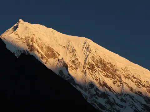
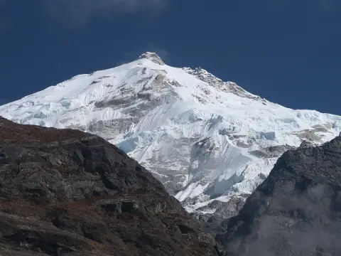
Actually, Langtang National Park really pulls you in with its dramatic Himalayan scenery. Tucked in central Nepal, the park stretches across the Nuwakot, Rasuwa, and Sindhupalchok districts and covers a massive 1,710 square kilometers. The elevation jumps from as low as 1,000 meters all the way up to Langtang Lirung at 7,245 meters, so you get everything from thick forests and wild rivers to high alpine meadows. You’ll spot wildlife roaming around and catch glimpses of Tamang communities keeping their traditions alive.
Meanwhile, trekkers come for the breathtaking trekking routes like Lagtang Valley Trek, glaciers feed sacred lakes, and the whole place has this mix of adventure and calm that’s hard to find anywhere else. It even links up with Tibet’s Qomolangma Preserve, making it a hotspot for biodiversity and conservation. Researchers flock here, and there’s a real sense that people are working hard to protect what makes Langtang special.
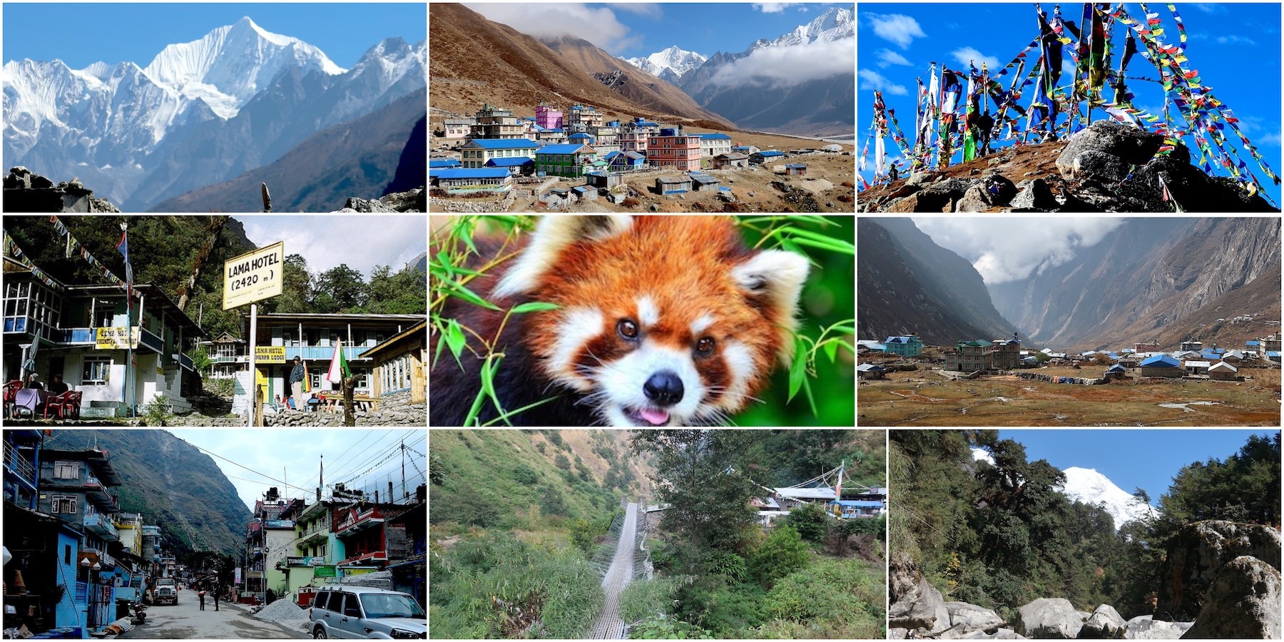
In fact, the park isn’t just about the scenery—it’s an experience. Hikers make their way up to Kyanjin Gompa at 3,870 meters for mountain views that honestly feel unreal. Gosaikunda Lake, sitting at 4,380 meters, draws pilgrims during festivals and holds deep religious meaning. With 68 named peaks—including the striking Dorje Lakpa at 6,966 meters—the landscape never gets old. You’ll find rhododendrons, oaks, red pandas, and even elusive snow leopards in these woods.
Unfortunately, the 2015 earthquake hit the area hard, but the communities rebuilt and kept things moving. Tourism now helps support the locals, and you’ll even find cheese factories in Kyanjin. Trails like the Langtang Valley keep drawing trekkers from all over the world. Weather shifts with the altitude—expect rain in summer, snow in winter—so visitors need to come prepared. In the end, Langtang National Park isn’t just a slice of Nepal’s wilderness; it’s the real thing, alive and thriving.
Key Geographical Features:
Area: 1,710 km², including a 420 km² buffer zone added in 1998.
Elevation Range: 1,000 m to 7,245 m, creating varied climates and habitats.
Location: About 30 km north of Kathmandu, making it accessible.
Borders: Linked with Qomolangma National Nature Preserve in Tibet.
Major Mountains in Langtang National Park
Elevation (m)
Langtang Lirung
7,245
Dorje Lakpa
6,966
Langshisha Ri
6,427
Yala Peak
5,500
Notable Attractions and Wildlife:
Sacred Sites: Gosaikunda Lake (4,380 m) draws Hindu and Buddhist pilgrims.
Villages: Kyanjin Gompa (3,870 m) features ancient monasteries and cheese production.
Fauna: Home to red pandas, Himalayan black bears, and snow leopards.
Flora: Rhododendron forests bloom in spring, with pines at higher elevations.
Origin of Langtang National Park
Starting back when Nepal began focusing on nature protection, a push emerged during the 1970s. Officials wanted safe spaces high in the mountains. By 1970, royal backing turned that idea into something real. That year marked Langtang becoming the first area set aside in the Himalayas just for preservation. Back then, in 1976, officials announced the park through a government notice. That step turned it into Nepal’s fourth space set aside for protection. Saving rare plants and animals was one of its main goals.
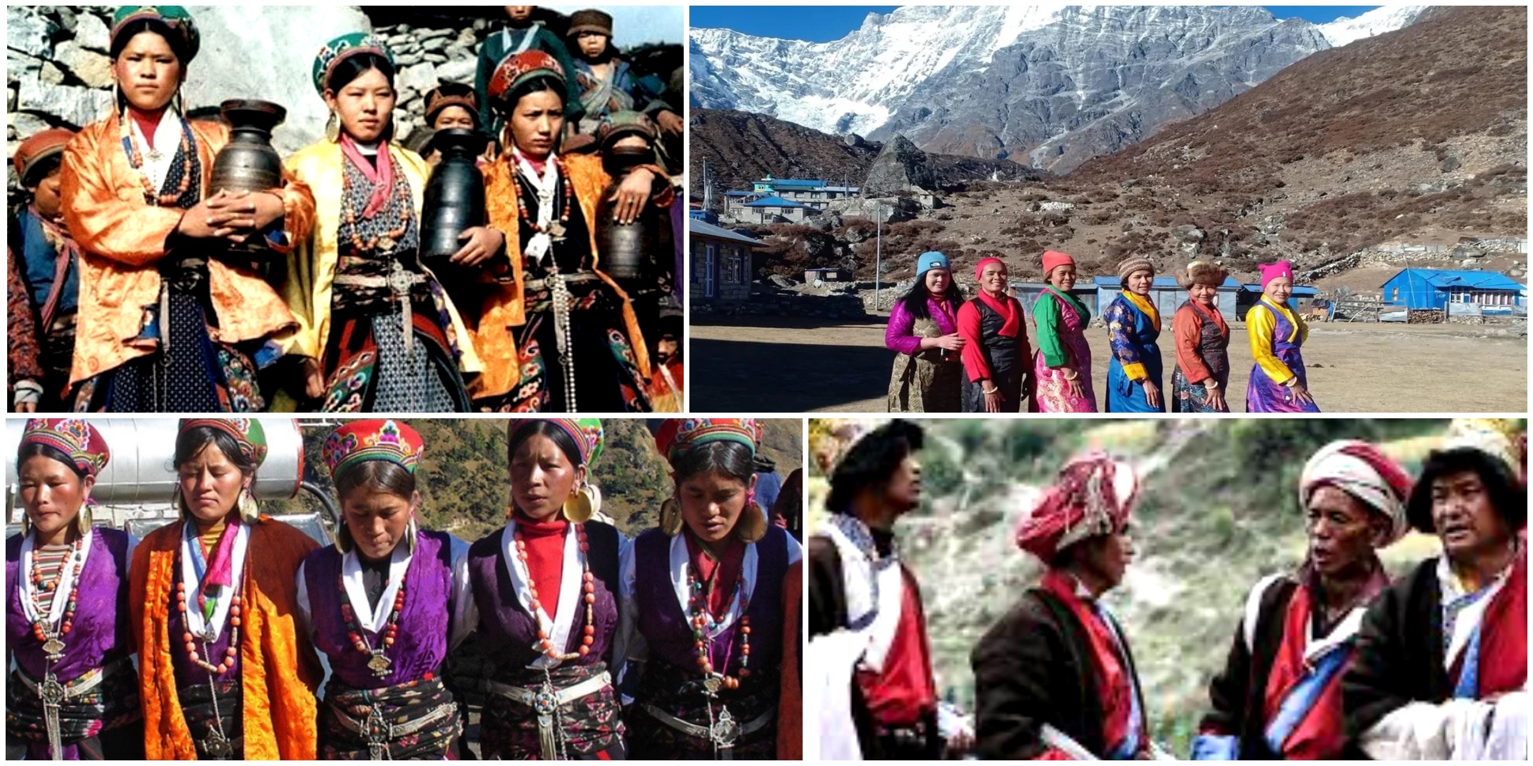
Still, another purpose mattered just as much - keeping Tamang traditions alive. Over mountain tops, old trails linked Nepal to Tibet. Through those peaks, silk journeys wound their way slowly. Shaking ground came many times after that. Still, strength grew stronger through each trial. From such beginnings, care for nature quietly began.
Here, Langtang National Park showed up on the map in 1976. That year, it claimed status as Nepal’s initial protected stretch in the high Himalayas. Its beginning size held firm at 1,710 square kilometers. By 1998, an added surrounding belt tacked on 420 more. Protecting living variety stood central from the start. Long ago, people called Tamang came to live here. Centuries passed since their arrival. Following yaks led them to rich valleys. From that tale, the word Langtang was born. Red pandas now have safeguards in place. Snow leopards too are under shelter.
In 1952, cheesemaking began through Swiss guidance. Afterward, visitors slowly increased over time. After the 2015 quake, rebuilding began piece by piece. Because of that moment, roots took hold in heritage and memory. What grew next still shapes how people move forward.
Historical Milestones:
1970: Royal approval designates Langtang as a protected area.
1976: Park officially gazetted, covering three districts.
1979: Added to UNESCO World Network of Biosphere Reserves (per some sources).
1998: Buffer zone addition enhances community involvement.
2015: Earthquake recovery strengthens resilience.
Key Establishment Facts
Details
Established Year
1976
Initial Area (km²)
1,710
Buffer Zone Added (km²)
420
Governing Body Department of National Parks and Wildlife Conservation
Highest Peak at Origin Langtang Lirung (7,245 m)
Cultural and Historical Influences:
Ethnic Origins: Tamang people of Tibetan descent settled in the 15th century.
Trade Routes: Ancient silk paths linked Nepal and Tibet via high passes.
Conservation Focus: Protected endangered species like snow leopards.
Modern Developments: Cheese factory established in 1952 by Swiss aid.
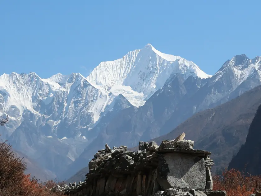
Actually, Langtang National Park is the kind of place that leaves you speechless. Massive Himalayan peaks rise all around—Langtang Lirung stands tall at 7,227 meters, and you can’t miss Dorje Lakpa dominating the horizon. Glaciers slice through the valleys, carving out gorges so deep they almost swallow sound. When spring hits, alpine meadows explode with color.
Langtang National Park is famous for its snow-capped peaks, red panda habitat, alpine landscapes, Buddhist culture, and beautiful trekking routes near Kathmandu.
Likewise, Gosaikunda, the sacred lake at 4,380 meters, brings in pilgrims every year. Villages like Kyanjin Gompa (3,870 m) aren’t just stops on a map—they’re windows into local culture. And for anyone who loves wildlife, spotting a red panda in the bamboo groves or catching a glimpse of a snow leopard on the rocks is pure adrenaline.
Moreover, there’s a lot to do here in Langtang National Park. The Langtang Valley Trek snakes through thick forests and delivers you to sweeping viewpoints like Kyanjin Ri (4,773 m) and Tserko Ri (5,000 m). The Tamang Heritage Trail isn’t just a walk; it’s a journey into the traditions of the region’s people.
If you’re after a mix of spirituality and scenery, the Gosaikunda Lake Trek does the trick. Cheese factories in the high villages? Absolutely—they’re part of the experience. The region’s no stranger to hardship, either. Earthquakes have tested these communities, but they always rebuild, tougher than before. Langtang is a place where adventure and calm live side by side.
Every year, explorers from around the world come here, and honestly, it’s easy to see why. The park doesn’t just offer a trip. It gives you memories that stick.
Key Trekking Attractions:
Langtang Valley Trek: Explores glacial valleys and Tamang villages, reaching Kyanjin Gompa (3,870 m).
Gosaikunda Lake Trek: Visits sacred Gosaikunda Lake (4,380 m), ideal for pilgrims.
Tamang Heritage Trail: Highlights cultural heritage and local lifestyles.
Viewpoints: Kyanjin Ri (4,773 m) and Tserko Ri (5,000 m) offer 360-degree Himalayan views.
Major Mountains and Elevations
Elevation (m)
Notable Feature
Langtang Lirung
7,227
Highest peak, glacial surroundings.
Dorje Lakpa
6,966
Prominent in valley skyline.
Gangchenpo
6,387
Adds to panoramic vistas.
Yala Peak
5,520
Popular for climbing expeditions.
Cultural and Natural Highlights
The Tamang people are the main ethnic group in the Langtang region, preserving traditional lifestyles and unique Himalayan cultural heritage in Nepal.
Ethnic Communities: Tamang and Sherpa groups preserve traditions in villages like Langtang (3,430 m).
Wildlife Spots: Opportunities to see red pandas and snow leopards in diverse habitats.
Glaciers and Lakes: Over 70 glaciers and alpine lakes enhance scenic beauty.
Accessibility: Just 30 km from Kathmandu, making it Nepal's most reachable Himalayan park.
Adventure Activities Description Elevation Range (m):
Mountaineering
Climbing peaks like Yala Peak
4,000-7,000
Rock Climbing
Challenging routes in valleys
2,000-4,000
River Rafting
On Trishuli River near park
1,000-2,000
Wildlife Watching
Spotting endangered species
1,000-5,000
Major Flora and Fauna in Langtang National Park
Meanwhile, Langtang National Park bursts with life. You get everything from subtropical forests at the base to chilly alpine meadows up high. Head into the lower forests, and you’ll find oaks everywhere. Climb a bit, and rhododendrons take over, splashing the hillsides with color. Up in the meadows, tough little shrubs hang on, no matter how cold it gets.
Major flora and fauna of Langtang National Park, including rhododendron forests, Himalayan wildlife, rare red pandas, birds, and diverse mountain ecosystems in Nepal.
Likewise, wildlife here is just as impressive. Red pandas sneak through the bamboo. Snow leopards slip across the rocks where most people never go. The skies are alive with birds—more than 250 species, actually. If you look closer, butterflies flutter everywhere, adding their own pop of color. And it’s not just birds and butterflies—Himalayan tahrs scale cliffs like it’s nothing, and musk deer hide in the shadows.
Moreover, the Langtang National park works hard to protect all this flora and fauna. Thanks to those efforts, endangered species still have a home here, and the whole place keeps its wild, balanced feel. Scientists come to study it all, and nature lovers can’t seem to stay away. Walk the trails, and you’ll feel the energy—plants, animals, and people all mixing together. That’s Langtang: a living example of how wild places should be.
Major Flora Categories:
Subtropical Zone: Sal (Shorea robusta), oak, and maple trees in lower elevations (1,000-2,000 m).
Temperate Zone: Oak, hemlock, larch, and pine forests (2,000-3,000 m).
Sub-Alpine Zone: Fir, juniper, and rhododendron species (3,000-4,000 m).
Alpine Zone: Scrub, grasslands, and meadows above 4,000 m, with over 1,000 plant species total.
Key Mammal Species
Habitat Elevation (m)
Conservation Status
Red Panda
2,000-3,000
Endangered
Snow Leopard
Above 4,000
Vulnerable
Himalayan Black Bear
1,000-3,000
Vulnerable
Musk Deer
2,500-3,500
Endangered
Bird and Other Fauna Highlights:
Birds: Over 250 species, including Himalayan monal, impeyan pheasant, eagles, and vultures.
Other Mammals: Himalayan tahr, goral, langur monkeys, wild boar, and serow.
Butterflies: 70 species thrive in forests.
Reptiles/Amphibians: Limited to lower altitudes, including frogs and lizards.
Vegetation Ecosystems
Number of Types
Elevation Range (m)
Tropical Forests
Upper
Below 1,000
Temperate Forests
Mid
1,000-3,000
Alpine Scrub
High
Above 3,500
Grasslands
Varied
3,000-5,000
Best Time to Visit Langtang National Park
If you want the best out of Langtang National Park, go in spring or autumn. March to May is just gorgeous—clear skies, bright rhododendrons everywhere, and daytime temperatures that sit comfortably between 10 and 20 degrees. Nights get a bit chilly, but nothing extreme. Come autumn, from September through November, the air turns crisp and the views? You can see all the way to Langtang Lirung, standing tall at 7,227 meters. Trails stay dry, footing’s good, and the scenery is at its peak. Honestly, these are the months trekkers dream about.
Here, that said, the park’s open all year, but not every season’s friendly. Monsoon hits from June to August, dumping heavy rain and making landslides a real headache on the trails. Winter? Think snow in the high country from December to February, and nights that bite below freezing. Still, if you’re after wildflowers, spring is where the magic happens. If you want razor-sharp mountain views—Dorje Lakpa at 6,966 meters is a showstopper—pick autumn.
If crowds aren’t your thing, aim for early March or late November. You get decent weather and a bit more breathing room. No matter when you go, show up prepared. But if you’re after that perfect mix of safety, beauty, and experience, spring and autumn are tough to beat.
Seasonal Overview for Visiting:
Spring (March–May): Ideal for blooming flowers, mild weather, and clear views; rhododendrons flourish below 3,000 m.
Autumn (September–November): Peak season with stable skies, crisp air, and excellent visibility of peaks like Langtang Lirung (7,227 m).
Summer/Monsoon (June–August): Heavy rainfall, slippery trails, and landslide risks; avoid for most visitors.
Winter (December–February): Snowy high altitudes above 4,000 m, cold temperatures; suitable only for experienced trekkers.
Peak crowds occur in October and April; book accommodations early.
Shoulder seasons (early March, late November) offer fewer people and good weather.
Check forecasts for high passes like Laurebina La near Gosaikunda (4,380 m).
Spring highlights flora; autumn emphasizes crisp Himalayan panoramas.
Major Activities You Do During Your Visit to Langtang National Park
Under blue skies, Langtang National Park pulls in those who crave movement. Not just walking - trekking shapes nearly every visit. Paths wind through thick green valleys, quiet except for boots on stone. One goal stands high: Kyanjin Gompa at 3,870 meters above sea level.
From there, smaller trails peel off toward ridges with wide sightlines. Animals appear without warning, sudden flickers in the underbrush. Moments of meeting people deepen what could be only scenery. Homes of the Tamang open doors to strangers passing by. In this way, land and tradition fold together, step after step. Anyone can join, so long as they move at their own pace. Because of this, time spent here sticks with people.
Kyanjin Gompa in Langtang Valley, Nepal, is a peaceful Himalayan settlement surrounded by snow-capped mountains and a major highlight of the Langtang Valley Trek.
Likewise, finding trails through high valleys shapes much of what happens here. Sunrise spreads across the horizon when people reach Kyanjin Ri, standing at 4,773 meters. Gosaikunda Lake lies quiet at 4,380 meters, a place many pause to wander near. Some turn toward steeper ground, aiming for summits such as Yala Peak, which rises to 5,520 meters.
Moreover, some travelers try yak cheese while moving through village homes. Pictures taken here show mountains and skies in sharp detail. Still, many unwind inside warm teahouses with steam rising from cups. Walking paths wind through trees where birds call and plants bloom unseen elsewhere. Because of this range, every person finds something that fits their pace. Adventure hides beside quiet moments across the land. Memories form slowly, then stay for years without fading.
Primary Trekking Activities:
Langtang Valley Trek: Follows trails to Kyanjin Gompa (3,870 m), passing forests and villages.
Gosaikunda Lake Trek: Climbs to sacred Gosaikunda Lake (4,380 m) for pilgrimage and views.
Viewpoint Hikes: Ascend Kyanjin Ri (4,773 m) and Tserko Ri (5,000 m) for panoramic Himalayan vistas.
Tamang Heritage Trail: Explores cultural villages like Gatlang and Briddim.
Popular Viewpoints and Hikes
Elevation (m)
Highlights | Difficulty
Kyanjin Ri
4,773
Sunrise over Langtang Lirung (7,227 m) | Moderate
Tserko Ri
5,000
360-degree views of multiple peaks | Challenging
Kyangen Ri
4,600
Scenic valley overlooks | Moderate-Challenging
Yala Peak Summit
5,520
Non-technical climbing opportunity | Advanced
Cultural and Nature-Based Activities:
Village Exploration: Visit Tamang communities, monasteries, and cheese factories in Kyanjin Gompa (3,870 m).
Wildlife Watching: Spot red pandas, Himalayan black bears, and birds in forests (1,000–4,000 m).
Photography and Relaxation: Capture rhododendrons, glaciers, and prayer flags; enjoy teahouse stays.
Mountaineering: Attempt peaks like Dorje Lakpa (6,966 m) with guides.
Additional Experiences:
Hot springs at Tatopani for relaxation after hikes.
Birdwatching with over 250 species in diverse habitats.
Cultural immersion through homestays and local festivals.
General Rules to Follow While Visiting Langtang National Park
When you visit Langtang National Park, you need to act responsibly. Local customs matter here, so trekkers make a point to show respect. Stick to the marked trails—don’t wander off. You’ll always see groups with licensed guides, not just for their knowledge, but because it’s about safety too. Carry your permit at all times and skip the single-use plastics. If you’re camping, only use the sites set aside for that. All these rules, simple as they sound, go a long way—they keep the ecosystems and wildlife safe. Every mindful step helps the park stay wild.
Actually, safety and sustainability come first in Langtang. Since 2025, hiring a licensed guide isn’t just smart, it’s the rule. Trails near Langtang Lirung (that’s 7,227 meters up) are clearly marked—stick to them. In villages like Kyanjin Gompa (3,870 meters), travelers show real respect for Tamang culture.
Everyone packs out their trash. Don’t feed the animals, and keep noise down. These habits actually make a difference. They protect the place, and honestly, they make the whole experience better for everyone. In the end, following these rules means you’re helping to keep Langtang as special as it is now—maybe even better for the next person who comes along.
Trekkers visiting Langtang National Park must follow park rules and pay the required entry fees before starting the Langtang Valley Trek in Nepal.
Essential General Rules:
Hire a licensed trekking guide: Mandatory for all trekkers since February 2025 to ensure safety and support locals.
Obtain required permits: Carry Langtang National Park Entry Permit and arrange through agencies.
Stay on designated trails: Avoid shortcuts to prevent erosion and protect vegetation.
Respect wildlife: Maintain distance, do not feed animals like red pandas or snow leopards.
No littering: Pack out all waste; use designated bins or carry back to lower elevations.
Environmental and Cultural Guidelines:
Use eco-friendly practices: Minimize plastic use; opt for reusable items.
Respect local customs: Ask permission before photographing people; dress modestly in villages.
Camp responsibly: Use established campsites; no fires in restricted zones.
Altitude awareness: Acclimatize properly; descend if symptoms appear above 3,000 m.
Key Rules
Category
Specific Rule | Reason | Enforcement
Safety & Guidance
Licensed guide required
Enhances safety, prevents accidents | Checked at entry points.
Reduces pollution in high altitudes | Fines possible for violations.
Wildlife & Nature
Do not disturb flora/fauna
Preserves biodiversity | Park regulations enforced.
Additional Tips for Visitors:
Follow Leave No Trace principles.
Inform teahouse owners of plans for emergency support.
Avoid off-path exploration near glaciers or high passes.
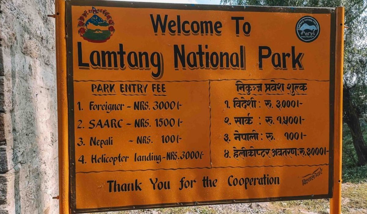
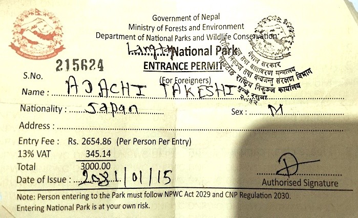
Entry Tickets and Fees for Langtang National Park
If you want to explore Langtang National Park, you’ll need an entry permit. Foreigners pay the standard rate, while SAARC nationals get a discount, and Nepali citizens pay just a small fee. Kids under 10? They get in for free. These fees aren’t just for show—they go straight into conservation, trail upkeep, and making sure the park stays beautiful and safe for everyone.
Permit required for trekking in Langtang National Park, Nepal.
Here’s how the pricing breaks down: foreigners usually pay NPR 3,000 which includes VAT. SAARC visitors pay NPR 1,500 , and Nepali trekkers just NPR 100. You can pick up your permit in Kathmandu or right at entry points like Dhunche. Starting in 2025, trekking agencies will arrange permits for you if you’re with a guide, so it’s smart to budget for that ahead of time. The fees are the same for most treks, including popular routes to places like Gosaikunda (4,380 m). In short, your ticket helps protect the park and keeps your adventure safe.
Entry Permit Fees Breakdown (Current as of 2025-2026):
Discounted rate Minimal fee | Agencies for guided treks.
Related Requirements and Costs:
Licensed Guide: Mandatory since February 2025; arranged through registered agencies (costs vary by duration/group).
TIMS Card: Often bundled via agencies (previously NPR 1,000-2,000; now agency-handled with guide requirement).
No separate regional tax mentioned for Langtang.
Permit Process Tips:
Obtain in advance from Nepal Tourism Board in Kathmandu for convenience.
Carry passport copy for registration.
Permits checked multiple times along trails.
Fees support wildlife protection and community development.
Kathmandu to Langtang National Park access
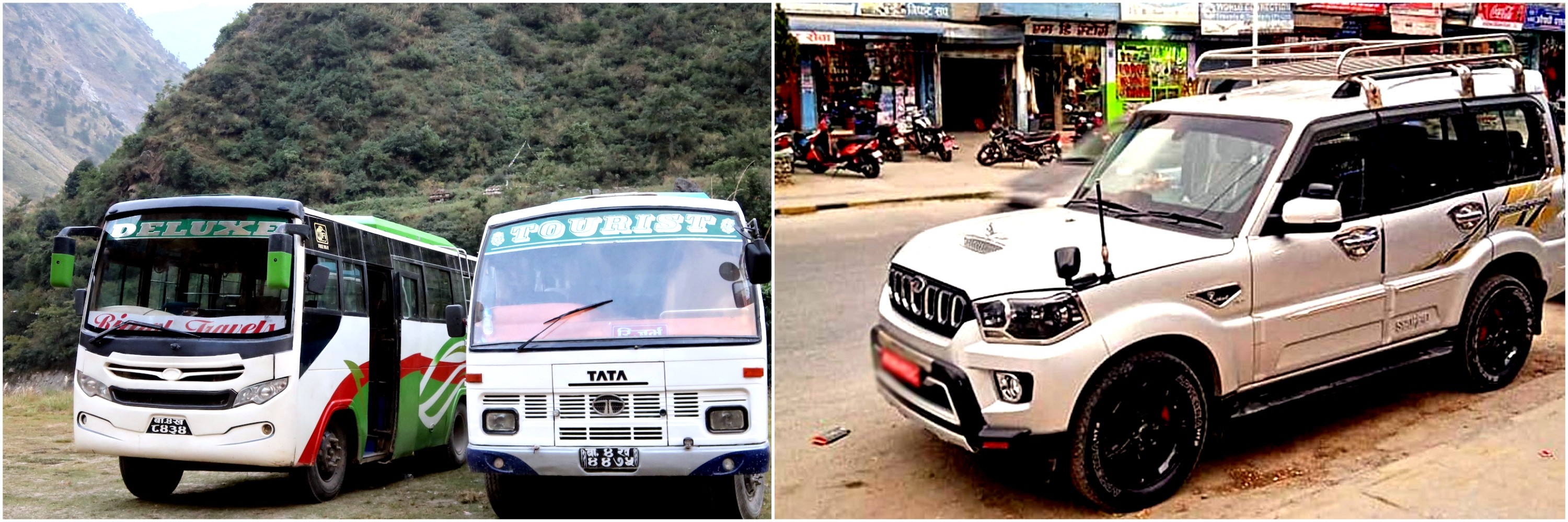
Actually, getting to Langtang National Park is straightforward from Kathmandu. Travelers can get bus/jeep from Kathmandu to Syabrubesi directly. From there, trekkers head out along roads that lead directly to the trailhead. Driving north, buses and jeeps follow the path through Trishuli Bazaar. After that, the journey continues past Dhunche, winding upward. Eventually it reaches Syabrubesi, sitting at 1,550 meters above sea level. A stretch of roughly 122 kilometers makes up the route.
Transportation options for the Langtang Valley Trek in Nepal include local public buses and private jeeps traveling from Kathmandu to Syabrubesi, the main gateway to the Langtang region.
While public buses offer low-cost rides, private jeeps cut down time on the road. Because of these choices, flying isn’t part of the picture. What sets the park apart is how easy it is to reach. Convenience defines the experience from start to finish. Trekkers show up here when they want a fast route into the Himalayas. Because of that, getting here easily makes it more favored
Getting to Langtang is simple by public transit. From Kathmandu, buses leave either at Machhapokhari or Gongabu. Travel time ranges from seven to nine hours, weather permitting. A jeep gets you there faster, usually between five and eight. The route twists past rolling hills, cutting through narrow valleys along the way. Views unfold beautifully as you move forward.
When rain falls heavily, some parts get tricky. Paths stay clearer when skies are free of storms. Best to start walking before crowds gather. People of many backgrounds find their way here without trouble. The route heads close to a tall peak called Langtang Lirung. Even with challenges, few places in Nepal open up so easily.
Transport Options from Kathmandu:
Public/Local Bus: Cheapest option; departs early morning from Machhapokhari or Gongabu Bus Park; costs NPR 700-1,300 (≈USD 6-10) per person; takes 7-10 hours.
Shared Jeep: Faster and more comfortable than bus; moderate price; reduces travel time slightly.
Private Jeep: Most flexible and comfortable; ideal for groups; costs NPR 15,000-25,000 (≈USD 150-200) per vehicle one-way; takes 5-8 hours.
Private Car/Taxi: Offers personalized stops; similar pricing to private jeep.
Route Details
Distance | Duration
Key Stops | Notes
Kathmandu to Syabrubesi (Main Starting Point)
122 km | 6-9 hours
Trishuli Bazaar, Dhunche | Paved highways mix with rough mountain roads; scenic river valleys.
Kathmandu to Dhunche (Alternative Entry)
100 km | 5-7 hours
Trishuli Bazaar | Shorter for some treks like Gosaikunda.
Return Journey
Same as outbound | 6-9 hours
Same route | Book in advance during peak seasons.
Accessibility Tips:
Roads improve but remain winding; motion sickness possible.
Check weather and road status before travel.
Permits checked at entry points like Dhunche or Syabrubesi.
No domestic flights required, unlike Everest region.
Sustainable Tourism in Langtang National Park
Out here, Langtang National Park puts sustainable tourism into motion every day. Local people take charge when it comes to protecting nature. After the 2015 quake, villages rose again through steady work. Instead of outside operators, families run guesthouses now. When travelers walk these trails, their choices back low-impact habits. Because guides talk openly about trash, guests start thinking twice.
Besides boosting local incomes, tourism helps safeguard creatures such as red pandas. Balance inside the park stays intact because of this. Long-term protection grows from mindful methods. Visits happen with care since awareness spreads quietly
Likewise, homegrown efforts keep travel alive in Langtang. Teahouses open their doors, guided by people who live here. Tree planting becomes a shared mission, carried out hand in hand. Trails stay clean because guests respect the land they walk on. Staying with families reveals daily rhythms, unfiltered. Less plastic slips into view thanks to quiet campaigns behind the scenes. After tremors shook the region, rebuilding chose nature over speed. So tourism gives strength to Tamang people. Habitat safeguards around Gosaikund rise because of visitor support. In total these actions bring good results. Culture in Langtang region stays alive while landscapes remain untouched. This protected space shows how mountain travel can work fairly.
Key Sustainable Practices:
Community-Based Tourism: Locals operate homestays, lodges, and cheese factories; direct income supports families.
Rebuilt Villages: New structures use earthquake-resistant designs; trails restored quickly.
Economic Revival: Tourism as main income; empowers locals after devastation.
International Support: NGOs aided reconstruction; focused on sustainable models.
Eco-Friendly Rebuilding: Emphasized biodiversity protection and community empowerment.
Sustainable Initiative
Description
Benefit | Involved Parties
Homestays & Local Lodges
Visitors stay with families
Economic empowerment, cultural exchange | Tamang communities.
Waste Reduction Programs
Carry-in/carry-out policy
Reduces pollution in fragile areas | Trekkers, guides, park authorities.
Reforestation & Monitoring
Tree planting, wildlife patrols
Preserves flora/fauna | Local youth, conservation groups.
Guide Education
Licensed guides promote eco-practices
Raises awareness | Trekking agencies, TAAN.
Additional Eco-Tourism Highlights:
Supports yak cheese production in villages like Kyanjin Gompa (3,870 m).
Encourages low-impact activities like guided wildlife watching.
Community-led clean-up drives maintain trails.
FAQS:Langtang National Park
1. What is Langtang National Park? Langtang National Park is Nepal’s first Himalayan national park. It was established in 1976. The park covers 1,710 kilometers in Rasuwa and Sindhupalchok districts. It has different landscapes, from subtropical forests to alpine meadows, snow-capped peaks, glaciers and a lot of different plants and animals. Many people like to trek. 2. When was Langtang National Park established? Langtang National Park was established in 1976. It was Nepal’s Himalayan national park and the country’s fourth protected area. The park was created to protect the Himalayan ecosystem, rare animals and cultural heritage of the region. 3. What are the major highlights of Langtang National Park? The park has highlights. These include Langtang Valley, Gosainkunda Lake, Kyanjin Gompa, Tamang villages, glaciers and great views of Langtang Lirung. Visitors can go trekking learn about the culture and see the beautiful Himalayan scenery near Kathmandu. 4. What flora and fauna are found in Langtang National Park? The park has different plants, including rhododendrons, oaks, pines and alpine meadows. The park is home to pandas, snow leopards, Himalayan black bears, musk deer, Himalayan tahr and over 250 bird species. This makes it a special place for nature and wildlife. 5. What is the best time to visit Langtang National Park? The best times to visit are in the spring from March to May, when the rhododendrons are blooming. Autumn, from September to November is also great with mountain views and stable weather. These seasons are ideal for trekking and taking pictures. 6. What activities can I do in Langtang National Park? There are things to do in the park. These include trekking in Langtang Valley and to Gosainkunda climbing mountains watching birds spotting wildlife visiting Tamang villages and monasteries and taking pictures of the landscapes. 7. What are the general rules to follow in Langtang National Park? When visiting the park please do not litter, stay on the marked trails respect the culture do not disturb the wildlife and get the necessary permits. Following these rules helps protect the park and ensure tourism. 8. How much are the entry fees for Langtang National Park? Foreigners pay NPR 3,000. SAARC nationals pay NPR 1,500. Nepalis pay NPR 100. Children under 10 can enter for free. 9. How do I reach Langtang National Park from Kathmandu? To get to the park from Kathmandu take a bus or jeep to Syabrubesi. The drive takes 7-8 hours. Covers 120-122 kilometers. Syabrubesi is the gateway to the park and the starting point for most treks. 10. Why is Langtang National Park important for biodiversity? The park protects different ecosystems, from subtropical to alpine zones. It helps conserve endangered species like pandas and snow leopards. The park also preserves Himalayan plants across 14 different vegetation types. 11. Do I need a permit to visit Langtang National Park? Yes, you need a permit to visit the park. You need a Langtang National Park Entry Permit and a TIMS card. These help with conservation and can be obtained in Kathmandu or at the park entrance. 12. Is Langtang National Park suitable for beginners? Yes, many trails in the park like Langtang Valley are moderate and suitable for beginners. There are also teahouse facilities. However proper acclimatization and fitness preparation are recommended. 13. What cultural experiences does Langtang National Park offer? Visitors can experience the rich Tamang and Tibetan-influenced culture. This includes visiting villages, monasteries like Kyanjin Gompa, hospitality, festivals and local cuisine. 14. Can I see snow leopards or red pandas in Langtang National Park? It is possible to see snow leopards and red pandas in the park. Sightings are rare. Morning or guided treks can improve your chances of spotting them in their natural habitats. 15. How big is Langtang National Park? The park spans 1,710 kilometers. It extends from 1,000 meters to over 7,000 meters altitude. The park encompasses different landscapes and ecosystems in central Nepal. 16. What is sustainable tourism in Langtang National Park? Sustainable tourism in the park means minimizing impact supporting local Tamang communities respecting customs and contributing to conservation through responsible travel practices. 17. Are there glaciers in Langtang National Park? Yes, the park features glaciers, especially around Langtang Lirung and other peaks. These offer scenic beauty for trekkers and photographers. 18. What should I pack for a visit to Langtang National Park? When visiting the park, pack clothing, sturdy trekking boots, a rain jacket, sunglasses, sunscreen, water purification, a first-aid kit and a good sleeping bag for higher altitudes. 19. Can I do a short visit or day trip to Langtang National Park? Short visits are possible. Most attractions require multi-day treks. Day trips are limited. Helicopter tours or short hikes, from Syabrubesi are alternatives. 20. How does visiting Langtang National Park support local communities? Visiting the park helps support communities. Tourism revenue and trekking activities provide income to Tamang villages through teahouses, guides and porters. This aids -earthquake recovery and promotes sustainable community development.