[{"name":"Everest Base Camp Helicopter Tour","duration":"1","image_url":"https:\/\/www.havenholidaysnepal.com\/storage\/trip-galleries\/1\/thumb_6cd53005d75a86e373d31419d1b14d78.webp","offer_price":1195,"url":"https:\/\/www.havenholidaysnepal.com\/trips\/everest-base-camp-helicopter-tour"},{"name":"Everest Mountain Flight","duration":"1","image_url":"https:\/\/www.havenholidaysnepal.com\/storage\/trip-galleries\/4\/thumb_3b0b4f1d6f72b0ad224daf4752f2c6e0.jpg","offer_price":285,"url":"https:\/\/www.havenholidaysnepal.com\/trips\/everest-mountain-flight"},{"name":"Everest Short Trek","duration":"9","image_url":"https:\/\/www.havenholidaysnepal.com\/storage\/trip-galleries\/5\/thumb_BXPP3621.JPEG0.02033800 1727957098.webp","offer_price":995,"url":"https:\/\/www.havenholidaysnepal.com\/trips\/everest-short-trek"},{"name":"Gokyo Valley Trek","duration":"12","image_url":"https:\/\/www.havenholidaysnepal.com\/storage\/trip-galleries\/6\/thumb_10bc469b14731f23d3ce84a7092ad53f.jpg","offer_price":1195,"url":"https:\/\/www.havenholidaysnepal.com\/trips\/gokyo-valley-trek"},{"name":"15 days Annapurna Base Camp Trek","duration":"15","image_url":"https:\/\/www.havenholidaysnepal.com\/storage\/trip-galleries\/7\/thumb_87d1533bc45faf070990aef0579e4be4.jpg0.81855100 1728285496.webp","offer_price":785,"url":"https:\/\/www.havenholidaysnepal.com\/trips\/15-days-annapurna-base-camp-trek"},{"name":"Nepal Pilgrimage Tour","duration":"14","image_url":"https:\/\/www.havenholidaysnepal.com\/storage\/trip-galleries\/8\/thumb_02c3bcf2ad2e8a4c1703e90ae747b5f1.jpg","offer_price":1475,"url":"https:\/\/www.havenholidaysnepal.com\/trips\/nepal-pilgrimage-tour"},{"name":"UNESCO World Heritage Site Tour","duration":"10","image_url":"https:\/\/www.havenholidaysnepal.com\/storage\/trip-galleries\/9\/thumb_unesco-world-heritage-site-Lumbani-temple-buddhists-hindus-kathmandu-nepal0.36988600 17347617740.93089500 1737469667.webp","offer_price":715,"url":"https:\/\/www.havenholidaysnepal.com\/trips\/unesco-world-heritage-site-tour"},{"name":"Island Peak Climbing","duration":"16","image_url":"https:\/\/www.havenholidaysnepal.com\/storage\/trip-galleries\/11\/thumb_Island peak0.53947000 1734692503.webp","offer_price":2495,"url":"https:\/\/www.havenholidaysnepal.com\/trips\/island-peak-climbing"},{"name":"Upper Mustang Trek","duration":"18","image_url":"https:\/\/www.havenholidaysnepal.com\/storage\/trip-galleries\/12\/thumb_upper mustang 7 Oct-2024.jpg0.95398900 1728286166.webp","offer_price":2995,"url":"https:\/\/www.havenholidaysnepal.com\/trips\/upper-mustang-trek"},{"name":"Annapurna Circuit Trek","duration":"16","image_url":"https:\/\/www.havenholidaysnepal.com\/storage\/trip-galleries\/15\/thumb_tibetan-flags.jpg0.04843900 1728289138.webp","offer_price":985,"url":"https:\/\/www.havenholidaysnepal.com\/trips\/annapurna-circuit-trek"},{"name":"Gosainkunda Lake Trek","duration":"10","image_url":"https:\/\/www.havenholidaysnepal.com\/storage\/trip-galleries\/16\/thumb_5A8083B3-C007-41A8-853F-D0C37C97D235_1_105_c.jpeg0.52581200 1731845258.webp","offer_price":595,"url":"https:\/\/www.havenholidaysnepal.com\/trips\/gosainkunda-lake-trek"},{"name":"Zip-lining in Pokhara and Dhulikhel","duration":"1","image_url":"https:\/\/www.havenholidaysnepal.com\/storage\/trip-galleries\/18\/thumb_215f765e2ebc995dd5c800b4bfdbacc3.jpg","offer_price":82,"url":"https:\/\/www.havenholidaysnepal.com\/trips\/zip-lining-in-pokhara-and-dhulikhel"},{"name":"Annapurna Heli Tour","duration":"1","image_url":"https:\/\/www.havenholidaysnepal.com\/storage\/trip-galleries\/19\/thumb_d71a6bbb9fd4da8d1b567a5cdbdec85d.jpg","offer_price":555,"url":"https:\/\/www.havenholidaysnepal.com\/trips\/annapurna-heli-tour"},{"name":"Paragliding in Pokhara","duration":"1","image_url":"https:\/\/www.havenholidaysnepal.com\/storage\/trip-galleries\/20\/thumb_de788d2dd9726783431f882c007efae1.jpg","offer_price":65,"url":"https:\/\/www.havenholidaysnepal.com\/trips\/paragliding-in-pokhara"},{"name":"Ultra-Flight in Pokhara","duration":"1","image_url":"https:\/\/www.havenholidaysnepal.com\/storage\/trip-galleries\/21\/thumb_e27a9fb572a5c21611bb2a3c18e4b8f0.jpeg","offer_price":175,"url":"https:\/\/www.havenholidaysnepal.com\/trips\/ultra-flight-in-pokhara"},{"name":"Sarangkot Hiking","duration":"1","image_url":"https:\/\/www.havenholidaysnepal.com\/storage\/trip-galleries\/22\/thumb_100ef822fea19987166c6c1366215f15.jpg","offer_price":55,"url":"https:\/\/www.havenholidaysnepal.com\/trips\/sarangkot-hiking"},{"name":"Mera Peak Climbing","duration":"18","image_url":"https:\/\/www.havenholidaysnepal.com\/storage\/trip-galleries\/24\/thumb_d16ae3895f678cf26ffbf2455f541fb5.jpg0.31883400 1732617790.webp","offer_price":2475,"url":"https:\/\/www.havenholidaysnepal.com\/trips\/mera-peak-climbing"},{"name":"Lower Dolpo Trek","duration":"18","image_url":"https:\/\/www.havenholidaysnepal.com\/storage\/trip-galleries\/26\/thumb_Dolpo Galary - 1.JPG0.37725200 1727939952.webp","offer_price":2995,"url":"https:\/\/www.havenholidaysnepal.com\/trips\/lower-dolpo-trek"},{"name":"Nagarkot Sunrise\/Sunset Tour","duration":"1","image_url":"https:\/\/www.havenholidaysnepal.com\/storage\/trip-galleries\/27\/thumb_5147a5532644283a380f2e86f3857c13.jpg0.17748000 1728488108.webp","offer_price":30,"url":"https:\/\/www.havenholidaysnepal.com\/trips\/nagarkot-sunrise-sunset-tour"},{"name":"16 day Everest Base Camp Trek","duration":"16","image_url":"https:\/\/www.havenholidaysnepal.com\/storage\/trip-galleries\/28\/thumb_IMG_4311.JPG0.64984800 1727942213.webp","offer_price":1475,"url":"https:\/\/www.havenholidaysnepal.com\/trips\/16-day-everest-base-camp-trek"},{"name":"Ghorepani Poon Hill trek with Jungle Safari and Trishuli River Rafting -13 days","duration":"13","image_url":"https:\/\/www.havenholidaysnepal.com\/storage\/trip-galleries\/29\/thumb_Ghorepani Poon hill.jpg0.48460800 1728281439.webp","offer_price":795,"url":"https:\/\/www.havenholidaysnepal.com\/trips\/ghorepani-poon-hill-trek-with-jungle-safari-and-trishuli-river-rafting--13-days"},{"name":"Mardi Himal Trek","duration":"12","image_url":"https:\/\/www.havenholidaysnepal.com\/storage\/trip-galleries\/30\/thumb_s1.jpg0.62112600 1728200721.webp","offer_price":795,"url":"https:\/\/www.havenholidaysnepal.com\/trips\/mardi-himal-trek"},{"name":"Langtang Valley Trekking","duration":"10","image_url":"https:\/\/www.havenholidaysnepal.com\/storage\/trip-galleries\/31\/thumb_IMG_4702.JPG0.84916500 1727958504.webp","offer_price":685,"url":"https:\/\/www.havenholidaysnepal.com\/trips\/langtang-valley-trekking"},{"name":"Real Adventure Tour in Nepal","duration":"9","image_url":"https:\/\/www.havenholidaysnepal.com\/storage\/trip-galleries\/32\/thumb_ebd1b8cc78d90abe8b9003dd9a2f25bf.jpg0.82151300 1728213516.webp","offer_price":695,"url":"https:\/\/www.havenholidaysnepal.com\/trips\/real-adventure-tour-in-nepal"},{"name":"Luxury Tour in Nepal","duration":"10","image_url":"https:\/\/www.havenholidaysnepal.com\/storage\/trip-galleries\/33\/thumb_8574e61b252b18676b042caf30d830df.jpg","offer_price":1675,"url":"https:\/\/www.havenholidaysnepal.com\/trips\/luxury-tour-in-nepal"},{"name":"Luxury Everest Panorama Trek With EBC Heli Sightseeing","duration":"8","image_url":"https:\/\/www.havenholidaysnepal.com\/storage\/trip-galleries\/34\/thumb_URZL2397.JPEG0.01209600 1728027820.webp","offer_price":2575,"url":"https:\/\/www.havenholidaysnepal.com\/trips\/luxury-everest-panorama-trek-with-ebc-heli-sightseeing"},{"name":"13 day Everest Base Camp Trek with Helicopter","duration":"13","image_url":"https:\/\/www.havenholidaysnepal.com\/storage\/trip-galleries\/35\/thumb_IMG_4292.JPG0.70131500 1728029276.webp","offer_price":2095,"url":"https:\/\/www.havenholidaysnepal.com\/trips\/13-day-everest-base-camp-trek-with-helicopter"},{"name":"Manaslu Circuit Trek","duration":"16","image_url":"https:\/\/www.havenholidaysnepal.com\/storage\/trip-galleries\/36\/thumb_Mt Manaslu 03-Oct-2024.jpg0.65804900 1727938470.webp","offer_price":955,"url":"https:\/\/www.havenholidaysnepal.com\/trips\/manaslu-circuit-trek"},{"name":"Kanchenjunga Base Camp Trek","duration":"21","image_url":"https:\/\/www.havenholidaysnepal.com\/storage\/trip-galleries\/37\/thumb_Kanchanjunga Trek -!.jpg0.54744400 1727938497.webp","offer_price":2275,"url":"https:\/\/www.havenholidaysnepal.com\/trips\/kanchenjunga-base-camp-trek"},{"name":"Ganesh Himal and Sing-La Trek","duration":"18","image_url":"https:\/\/www.havenholidaysnepal.com\/storage\/trip-galleries\/38\/thumb_Ganesh Himal slider-1.jpg0.43764500 1727937722.webp","offer_price":2975,"url":"https:\/\/www.havenholidaysnepal.com\/trips\/ganesh-himal-and-sing-la-trek"},{"name":"Island Peak Climb with Everest Base Camp Trek","duration":"21","image_url":"https:\/\/www.havenholidaysnepal.com\/storage\/trip-galleries\/39\/thumb_2be428730fe83525bc85a010564f99de.jpg","offer_price":2750,"url":"https:\/\/www.havenholidaysnepal.com\/trips\/island-peak-climb-with-everest-base-camp-trek"},{"name":"Students' Adventure Tour in Nepal","duration":"12","image_url":"https:\/\/www.havenholidaysnepal.com\/storage\/trip-galleries\/41\/thumb_a926d22fbfe08cba271c41ac289b3fd2.jpg","offer_price":995,"url":"https:\/\/www.havenholidaysnepal.com\/trips\/students-adventure-tour-in-nepal"},{"name":"7 Day Poonhill Trek","duration":"7","image_url":"https:\/\/www.havenholidaysnepal.com\/storage\/trip-galleries\/42\/thumb_6196bd69036473293a2c24cc21ed57d7.jpg0.10880600 1728205378.webp","offer_price":555,"url":"https:\/\/www.havenholidaysnepal.com\/trips\/7-day-poonhill-trek"},{"name":"7 Days Annapurna Base Camp Trek","duration":"7","image_url":"https:\/\/www.havenholidaysnepal.com\/storage\/trip-galleries\/43\/thumb_IMG_2214.JPG0.08204900 1728202033.webp","offer_price":355,"url":"https:\/\/www.havenholidaysnepal.com\/trips\/7-days-annapurna-base-camp-trek"},{"name":"3 days Poonhill Trek","duration":"3","image_url":"https:\/\/www.havenholidaysnepal.com\/storage\/trip-galleries\/44\/thumb_Poon hill.jpg0.60816600 1731412954.webp","offer_price":165,"url":"https:\/\/www.havenholidaysnepal.com\/trips\/3-days-poonhill-trek"},{"name":"Poon Hill Luxury Trek with Chitwan-12 days","duration":"12","image_url":"https:\/\/www.havenholidaysnepal.com\/storage\/trip-galleries\/45\/thumb_Poom hill.jpg0.52074500 1730180532.webp","offer_price":1175,"url":"https:\/\/www.havenholidaysnepal.com\/trips\/poon-hill-luxury-trek-with-chitwan-12-days"},{"name":"Everest Luxury Trek-7 days","duration":"7","image_url":"https:\/\/www.havenholidaysnepal.com\/storage\/trip-galleries\/46\/thumb_ACRX9330.JPEG0.93236200 1728031275.webp","offer_price":1975,"url":"https:\/\/www.havenholidaysnepal.com\/trips\/everest-luxury-trek-7-days"},{"name":"Hindu Pilgrimage Tour in Nepal-10 days","duration":"10","image_url":"https:\/\/www.havenholidaysnepal.com\/storage\/trip-galleries\/47\/thumb_a94bf96a4d31decb419f6f828a3280d2.jpg","offer_price":995,"url":"https:\/\/www.havenholidaysnepal.com\/trips\/hindu-pilgrimage-tour-in-nepal-10-days"},{"name":"Everest Base Camp Short Trek-12 days","duration":"12","image_url":"https:\/\/www.havenholidaysnepal.com\/storage\/trip-galleries\/48\/thumb_IMG_4311.JPG0.52680100 1727945154.webp","offer_price":995,"url":"https:\/\/www.havenholidaysnepal.com\/trips\/everest-base-camp-short-trek-12-days"},{"name":"Everest Base Camp Hike 12 Days","duration":"12","image_url":"https:\/\/www.havenholidaysnepal.com\/storage\/trip-galleries\/49\/thumb_IMG_4260.JPG0.51729100 1728061234.webp","offer_price":1295,"url":"https:\/\/www.havenholidaysnepal.com\/trips\/everest-base-camp-hike-12-days"},{"name":"11 Days Everest Base Camp Trek","duration":"11","image_url":"https:\/\/www.havenholidaysnepal.com\/storage\/trip-galleries\/50\/thumb_IMG_4249.JPG0.21392500 1727946959.webp","offer_price":985,"url":"https:\/\/www.havenholidaysnepal.com\/trips\/11-days-everest-base-camp-trek"},{"name":"6 Days Annapurna Base Camp Trek","duration":"6","image_url":"https:\/\/www.havenholidaysnepal.com\/storage\/trip-galleries\/51\/thumb_6 days Abc.jpg0.58185400 1728200798.webp","offer_price":285,"url":"https:\/\/www.havenholidaysnepal.com\/trips\/6-days-annapurna-base-camp-trek"},{"name":"Annapurna Base Camp Trek","duration":"8","image_url":"https:\/\/www.havenholidaysnepal.com\/storage\/trip-galleries\/52\/thumb_IMG_2214.JPG0.29415700 1729487656.webp","offer_price":585,"url":"https:\/\/www.havenholidaysnepal.com\/trips\/annapurna-base-camp-trek"},{"name":"Everest Base Camp Trek with Helicopter Fly Out 10 Days","duration":"10","image_url":"https:\/\/www.havenholidaysnepal.com\/storage\/trip-galleries\/53\/thumb_IMG_4328.JPG0.52056600 1728058444.webp","offer_price":1875,"url":"https:\/\/www.havenholidaysnepal.com\/trips\/everest-base-camp-trek-with-helicopter-fly-out-10-days"},{"name":"Everest Base Camp Trek 14 Days","duration":"14","image_url":"https:\/\/www.havenholidaysnepal.com\/storage\/trip-galleries\/54\/thumb_Everest Base Camp Trek 14 days Oct 3 2024.JPG0.43202700 1727939745.webp","offer_price":1455,"url":"https:\/\/www.havenholidaysnepal.com\/trips\/everest-base-camp-trek-14-days"},{"name":"ABC Trek with Poonhill 11 Days","duration":"11","image_url":"https:\/\/www.havenholidaysnepal.com\/storage\/trip-galleries\/55\/thumb_ABC with fishtail.JPG0.21441100 1728277965.webp","offer_price":555,"url":"https:\/\/www.havenholidaysnepal.com\/trips\/abc-trek-with-poonhill-11-days"},{"name":"Muldai Hill Trek 9 Days","duration":"9","image_url":"https:\/\/www.havenholidaysnepal.com\/storage\/trip-galleries\/56\/thumb_7efee59f0a8c6817c8255bd2b9f3539d.jpeg0.19479300 1728213091.webp","offer_price":675,"url":"https:\/\/www.havenholidaysnepal.com\/trips\/muldai-hill-trek-9-days"},{"name":"Mardi Himal Trek 6 days","duration":"6","image_url":"https:\/\/www.havenholidaysnepal.com\/storage\/trip-galleries\/57\/thumb_slider 1.jpeg0.36909700 1728184981.webp","offer_price":590,"url":"https:\/\/www.havenholidaysnepal.com\/trips\/mardi-himal-trek-6-days"},{"name":"Mardi Himal Trek 7 days","duration":"7","image_url":"https:\/\/www.havenholidaysnepal.com\/storage\/trip-galleries\/58\/thumb_slider1.jpg0.61666600 1728206414.webp","offer_price":620,"url":"https:\/\/www.havenholidaysnepal.com\/trips\/mardi-himal-trek-7-days"},{"name":"Mardi Himal Trek 8 Days","duration":"8","image_url":"https:\/\/www.havenholidaysnepal.com\/storage\/trip-galleries\/59\/thumb_sli1.jpg0.38569100 1728206631.webp","offer_price":695,"url":"https:\/\/www.havenholidaysnepal.com\/trips\/mardi-himal-trek-8-days"},{"name":"14 Days Manaslu Trek","duration":"14","image_url":"https:\/\/www.havenholidaysnepal.com\/storage\/trip-galleries\/60\/thumb_sunrise-mt-manaslu-during-manaslu-circuit-larke-pass-trekking-himalaya-nepal (1)0.81855800 1738673284.webp","offer_price":885,"url":"https:\/\/www.havenholidaysnepal.com\/trips\/14-days-manaslu-trek"},{"name":"Dhampus-Sarangkot Trek with Chitwan 8 days","duration":"8","image_url":"https:\/\/www.havenholidaysnepal.com\/storage\/trip-galleries\/61\/thumb_Sarangkot Bhangyang.jpg0.75461400 1728210333.webp","offer_price":790,"url":"https:\/\/www.havenholidaysnepal.com\/trips\/dhampus-sarangkot-trek-with-chitwan-8-days"},{"name":"7 Days Golden Triangle Tour","duration":"7","image_url":"https:\/\/www.havenholidaysnepal.com\/storage\/trip-galleries\/62\/thumb_311ce1d117ee0ba75402a7c301bcdf830.73532400 1739179809.webp","offer_price":845,"url":"https:\/\/www.havenholidaysnepal.com\/trips\/7-days-golden-triangle-tour"},{"name":"Annapurna Circuit Trek 12 days","duration":"12","image_url":"https:\/\/www.havenholidaysnepal.com\/storage\/trip-galleries\/63\/thumb_IMG_20161024_092237.jpg0.57796600 1728289938.webp","offer_price":695,"url":"https:\/\/www.havenholidaysnepal.com\/trips\/annapurna-circuit-trek-12-days"},{"name":"Everest Base Camp Budget Trek 16 Days","duration":"16","image_url":"https:\/\/www.havenholidaysnepal.com\/storage\/trip-galleries\/64\/thumb_IMG_4423.JPG0.92579200 1728144669.webp","offer_price":958,"url":"https:\/\/www.havenholidaysnepal.com\/trips\/everest-base-camp-budget-trek-16-days"},{"name":"Poonhill Budget Trek 7 Days","duration":"7","image_url":"https:\/\/www.havenholidaysnepal.com\/storage\/trip-galleries\/65\/thumb_5be067852d0c5228d6f3155bc425c6b5.jpg","offer_price":395,"url":"https:\/\/www.havenholidaysnepal.com\/trips\/poonhill-budget-trek-7-days"},{"name":"Annapurna Base Camp Budget Trek 8 Days","duration":"8","image_url":"https:\/\/www.havenholidaysnepal.com\/storage\/trip-galleries\/66\/thumb_Pokhara.jpg0.16188000 1728212001.webp","offer_price":375,"url":"https:\/\/www.havenholidaysnepal.com\/trips\/annapurna-base-camp-budget-trek-8-days"},{"name":"The Real UNESCO Seven World Heritage Tour in Kathmandu 4 days","duration":"4","image_url":"https:\/\/www.havenholidaysnepal.com\/storage\/trip-galleries\/67\/thumb_Baudha Stupa.JPG0.63906900 1728201021.webp","offer_price":380,"url":"https:\/\/www.havenholidaysnepal.com\/trips\/the-real-unesco-seven-world-heritage-tour-in-kathmandu-4-days"},{"name":"Everest Base Camp Jeep Ride with Helicopter Return","duration":"14","image_url":"https:\/\/www.havenholidaysnepal.com\/storage\/trip-galleries\/68\/thumb_788ee5b63a6efb6f3c3d048b4270daca.JPG","offer_price":1895,"url":"https:\/\/www.havenholidaysnepal.com\/trips\/everest-base-camp-jeep-ride-with-helicopter-return"},{"name":"Annapurna Base Camp Jeep Ride with Helicopter Return 7 days","duration":"7","image_url":"https:\/\/www.havenholidaysnepal.com\/storage\/trip-galleries\/69\/thumb_abc jeep.jpg0.10280600 1728204064.webp","offer_price":1455,"url":"https:\/\/www.havenholidaysnepal.com\/trips\/annapurna-base-camp-jeep-ride-with-helicopter-return-7-days"},{"name":"Everest Base Camp Trek","duration":"15","image_url":"https:\/\/www.havenholidaysnepal.com\/storage\/trip-galleries\/70\/thumb_Everest Base Camp Trek 3 oct- 2024.JPG0.58445300 1727941472.webp","offer_price":1575,"url":"https:\/\/www.havenholidaysnepal.com\/trips\/everest-base-camp-trek"},{"name":"7 UNESCO World Heritage Tour Kathmandu 2 days","duration":"2","image_url":"https:\/\/www.havenholidaysnepal.com\/storage\/trip-galleries\/72\/thumb_Bhaktipur 3.jpg0.05559600 1728201496.webp","offer_price":150,"url":"https:\/\/www.havenholidaysnepal.com\/trips\/7-unesco-world-heritage-tour-kathmandu-2-days"},{"name":"Day Tour to UNESCO Heritage Sites","duration":"1","image_url":"https:\/\/www.havenholidaysnepal.com\/storage\/trip-galleries\/73\/thumb_228A1018.jpg0.79892500 1728199793.webp","offer_price":55,"url":"https:\/\/www.havenholidaysnepal.com\/trips\/day-tour-to-unesco-heritage-sites"},{"name":"Golden Triangle Tour in Nepal","duration":"8","image_url":"https:\/\/www.havenholidaysnepal.com\/storage\/trip-galleries\/74\/thumb_f54139cf9100f00015ffe0400687e946.webp","offer_price":588,"url":"https:\/\/www.havenholidaysnepal.com\/trips\/golden-triangle-tour-in-nepal"},{"name":"Everest Base Camp Honeymoon Tour by Helicopter with Pokhara","duration":"7 days","image_url":"https:\/\/www.havenholidaysnepal.com\/storage\/trip-galleries\/76\/thumb_RJTL7517.JPEG0.40261600 1731499989.webp","offer_price":9999,"url":"https:\/\/www.havenholidaysnepal.com\/trips\/everest-base-camp-honeymoon-tour-by-helicopter-with-pokhara"},{"name":"Yoga and Meditation Retreat Tour in Nepal","duration":"10 days","image_url":"https:\/\/www.havenholidaysnepal.com\/storage\/trip-galleries\/77\/thumb_decf8e33-6617-4400-9df0-63bf75509adf.JPG0.51948300 1731574810.webp","offer_price":2575,"url":"https:\/\/www.havenholidaysnepal.com\/trips\/yoga-and-meditation-retreat-tour-in-nepal"},{"name":"Chisapani-Nagarkot Trek","duration":"3","image_url":"https:\/\/www.havenholidaysnepal.com\/storage\/trip-galleries\/78\/thumb_0b64dfceaeab48ac36d685476bdebafb.webp","offer_price":165,"url":"https:\/\/www.havenholidaysnepal.com\/trips\/chisapani-nagarkot-trek"},{"name":"Chitwan Jungle Safari Tour","duration":"2","image_url":"https:\/\/www.havenholidaysnepal.com\/storage\/trip-galleries\/79\/thumb_IMG_1696.JPG0.28467800 1733054554.webp","offer_price":175,"url":"https:\/\/www.havenholidaysnepal.com\/trips\/chitwan-jungle-safari-tour"},{"name":"Kailash Overland Tour","duration":"16","image_url":"https:\/\/www.havenholidaysnepal.com\/storage\/trip-galleries\/80\/thumb_PA2605230.68496700 1735818657.webp","offer_price":2495,"url":"https:\/\/www.havenholidaysnepal.com\/trips\/kailash-overland-tour"},{"name":"4 nights 5 days Bhutan Tour","duration":"5","image_url":"https:\/\/www.havenholidaysnepal.com\/storage\/trip-galleries\/81\/thumb_PB0508470.23069500 1735828937.webp","offer_price":1265,"url":"https:\/\/www.havenholidaysnepal.com\/trips\/4-nights-5-days-bhutan-tour"},{"name":"Everest Base Camp Trek Without Flying","duration":"16","image_url":"https:\/\/www.havenholidaysnepal.com\/storage\/trip-galleries\/82\/thumb_308b054484eddc042e092e1ae2ae5586.webp","offer_price":685,"url":"https:\/\/www.havenholidaysnepal.com\/trips\/everest-base-camp-trek-without-flying"},{"name":"Everest Base Camp Trek by Land","duration":"16","image_url":"https:\/\/www.havenholidaysnepal.com\/storage\/trip-galleries\/83\/thumb_8f0f2784a3ae7343d193b64fe8d47c96.webp","offer_price":675,"url":"https:\/\/www.havenholidaysnepal.com\/trips\/everest-base-camp-trek-by-land"},{"name":"Everest Base Camp Trek by Jeep","duration":"16","image_url":"https:\/\/www.havenholidaysnepal.com\/storage\/trip-galleries\/84\/thumb_f82b3acdfc933bc3e0197624c001b0a6.webp","offer_price":675,"url":"https:\/\/www.havenholidaysnepal.com\/trips\/everest-base-camp-trek-by-jeep"},{"name":"Everest Base Camp Trek without Lukla Flight","duration":"16","image_url":"https:\/\/www.havenholidaysnepal.com\/storage\/trip-galleries\/85\/thumb_2d0acc76dc958e3122a3745074989914.webp","offer_price":675,"url":"https:\/\/www.havenholidaysnepal.com\/trips\/everest-base-camp-trek-without-lukla-flight"},{"name":"Langtang Valley Trek","duration":"7","image_url":"https:\/\/www.havenholidaysnepal.com\/storage\/trip-galleries\/86\/thumb_a845db06c5feada1478e8aed659fce97.webp","offer_price":199,"url":"https:\/\/www.havenholidaysnepal.com\/trips\/langtang-valley-trek"},{"name":"Everest Base Camp Trek with Gokyo Lake","duration":"17","image_url":"https:\/\/www.havenholidaysnepal.com\/storage\/trip-galleries\/87\/thumb_c6aa32f7654f2eda78134bc84ac70b79.webp","offer_price":1885,"url":"https:\/\/www.havenholidaysnepal.com\/trips\/everest-base-camp-trek-with-gokyo-lake"},{"name":"Everest Three Passes Trek","duration":"19","image_url":"https:\/\/www.havenholidaysnepal.com\/storage\/trip-galleries\/88\/thumb_db5364eaab56f5755da55868f8ca4258.webp","offer_price":1735,"url":"https:\/\/www.havenholidaysnepal.com\/trips\/everest-three-passes-trek"},{"name":"Annapurna Base Camp Trek From Pokhara","duration":"5","image_url":"https:\/\/www.havenholidaysnepal.com\/storage\/trip-galleries\/89\/thumb_49c813cf1054ff06108963924a78ee88.webp","offer_price":255,"url":"https:\/\/www.havenholidaysnepal.com\/trips\/annapurna-base-camp-trek-from-pokhara"},{"name":"Sarangkot Sunrise Tour from Pokhara","duration":"1","image_url":"https:\/\/www.havenholidaysnepal.com\/storage\/trip-galleries\/90\/thumb_932d995b8fb702634a23e8f9a0432c6e.webp","offer_price":35,"url":"https:\/\/www.havenholidaysnepal.com\/trips\/sarangkot-sunrise-tour-from-pokhara"},{"name":"Langtang Valley Trek-8 days","duration":"8","image_url":"https:\/\/www.havenholidaysnepal.com\/storage\/trip-galleries\/91\/thumb_81d3d0a6979c9ed01f65d5ade53820b2.webp","offer_price":250,"url":"https:\/\/www.havenholidaysnepal.com\/trips\/langtang-valley-trek-8-days"},{"name":"Manaslu Circuit Trek 12 days","duration":"12","image_url":"https:\/\/www.havenholidaysnepal.com\/storage\/trip-galleries\/92\/thumb_d8251bbef0c8a246a02bda5c150a27c2.webp","offer_price":675,"url":"https:\/\/www.havenholidaysnepal.com\/trips\/manaslu-circuit-trek-12-days"},{"name":"2 Days Poon Hill Trek","duration":"2","image_url":"https:\/\/www.havenholidaysnepal.com\/storage\/trip-galleries\/93\/thumb_9d8fa8f60767538857d6c7cb3a7fee8b.webp","offer_price":150,"url":"https:\/\/www.havenholidaysnepal.com\/trips\/2-days-poon-hill-trek"},{"name":"Upper Mustang Jeep Tour","duration":"6","image_url":"https:\/\/www.havenholidaysnepal.com\/storage\/trip-galleries\/94\/thumb_9a3098a6c860b87ad3339773ef5435b9.webp","offer_price":1095,"url":"https:\/\/www.havenholidaysnepal.com\/trips\/upper-mustang-jeep-tour"},{"name":"Tsum Valley Trek","duration":"11","image_url":"https:\/\/www.havenholidaysnepal.com\/storage\/trip-galleries\/95\/thumb_704a6a1eb293553827633dbd8ad7d22c.webp","offer_price":775,"url":"https:\/\/www.havenholidaysnepal.com\/trips\/tsum-valley-trek"},{"name":"Mardi Himal Trek from Pokhara","duration":"4","image_url":"https:\/\/www.havenholidaysnepal.com\/storage\/trip-galleries\/96\/thumb_c92e9ee49c2564a11c7a9ba593439efc.webp","offer_price":295,"url":"https:\/\/www.havenholidaysnepal.com\/trips\/mardi-himal-trek-from-pokhara"},{"name":"4 Days Poon Hill Trek","duration":"4","image_url":"https:\/\/www.havenholidaysnepal.com\/storage\/trip-galleries\/97\/thumb_c349e182edd0858f3e3409d945f0d2ec.webp","offer_price":215,"url":"https:\/\/www.havenholidaysnepal.com\/trips\/4-days-poon-hill-trek"},{"name":"Poon Hill Sunrise Jeep Tour from Pokhara","duration":"2","image_url":"https:\/\/www.havenholidaysnepal.com\/storage\/trip-galleries\/98\/thumb_509875052b16f6f9156db386e3592eb8.webp","offer_price":260,"url":"https:\/\/www.havenholidaysnepal.com\/trips\/poon-hill-sunrise-jeep-tour-from-pokhara"},{"name":"Muktinath Jeep Tour from Pokhara","duration":"3","image_url":"https:\/\/www.havenholidaysnepal.com\/storage\/trip-galleries\/99\/thumb_1651790cb7422703fe86d472a35d4f90.webp","offer_price":255,"url":"https:\/\/www.havenholidaysnepal.com\/trips\/muktinath-jeep-tour-from-pokhara"},{"name":"Ghorepani Poon Hill Trek from Pokhara","duration":"5","image_url":"https:\/\/www.havenholidaysnepal.com\/storage\/trip-galleries\/100\/thumb_27fa62452af4ea8e08544aaa035cc446.webp","offer_price":295,"url":"https:\/\/www.havenholidaysnepal.com\/trips\/ghorepani-poon-hill-trek-from-pokhara"},{"name":"Ghandruk, Poon Hill, Muktinath and Upper Mustang Tour","duration":"7 days","image_url":"https:\/\/www.havenholidaysnepal.com\/storage\/trip-galleries\/101\/thumb_a7dd15032cd9693005233b1df7dc63d3.webp","offer_price":685,"url":"https:\/\/www.havenholidaysnepal.com\/trips\/ghandruk-poon-hill-muktinath-and-upper-mustang-tour"},{"name":"Nar Phu Valley Trek with Annapurna Circuit","duration":"16 days","image_url":"https:\/\/www.havenholidaysnepal.com\/storage\/trip-galleries\/102\/thumb_21f5af1d6f698a6898b64413bcc19c69.webp","offer_price":1395,"url":"https:\/\/www.havenholidaysnepal.com\/trips\/nar-phu-valley-trek-with-annapurna-circuit"},{"name":"Poon Hill-Jhino Danda Hot Spring Trek","duration":"4","image_url":"https:\/\/www.havenholidaysnepal.com\/storage\/trip-galleries\/103\/thumb_b1a8563edaf102468aab613332282c6c.webp","offer_price":215,"url":"https:\/\/www.havenholidaysnepal.com\/trips\/poon-hill-jhino-danda-hot-spring-trek"},{"name":"Annapurna Base Camp Trek with Helicopter Return","duration":"4","image_url":"https:\/\/www.havenholidaysnepal.com\/storage\/trip-galleries\/104\/thumb_928d650987e2db5f449127b41966da53.webp","offer_price":895,"url":"https:\/\/www.havenholidaysnepal.com\/trips\/annapurna-base-camp-trek-with-helicopter-return"},{"name":"Annapurna Circuit with Tilicho Lake Trek","duration":"10","image_url":"https:\/\/www.havenholidaysnepal.com\/storage\/trip-galleries\/105\/thumb_a8c9d8bf4041c0fa676d6c239abfd24c.webp","offer_price":615,"url":"https:\/\/www.havenholidaysnepal.com\/trips\/annapurna-circuit-with-tilicho-lake-trek"}]
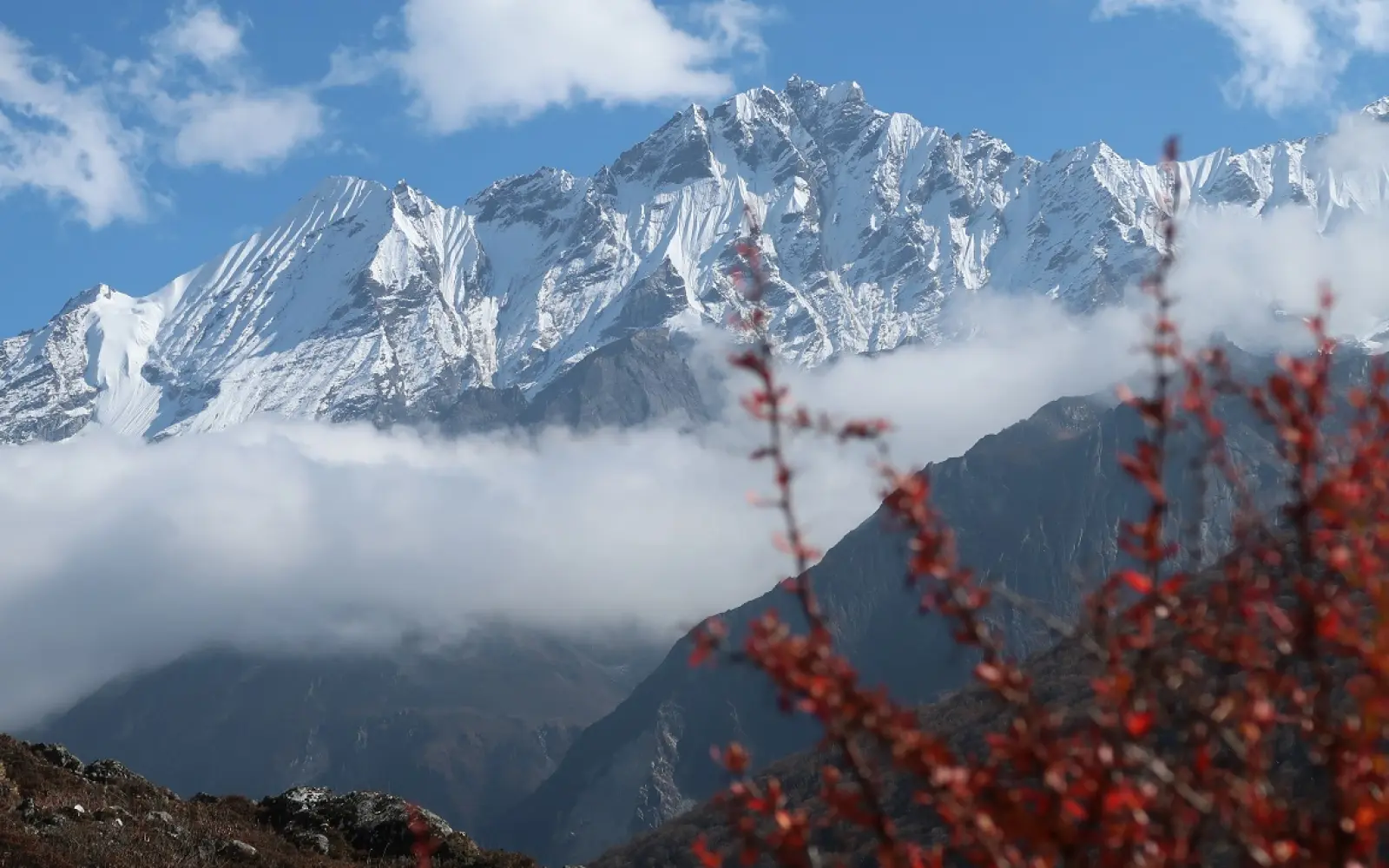
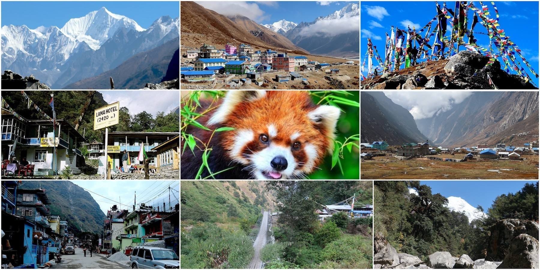
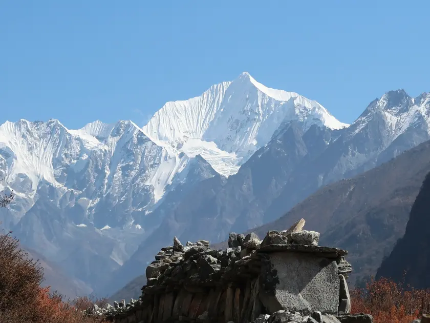
Meanwhile, the Langtang Valley Trek is one of the most resilient Himalayan treks in Nepal. It is located deep within the core of Langtang National Park. Tourists can enjoy magnificent views of glaciers. They can experience the vibrancy of Tamang culture. The trail has a unique tale of restoration and rejuvenation. The trek wanders through woods, streams and alpine pastures. The mighty Langtang Lirung (7,234m) can be seen piercing the clouds. Red pandas can be seen hiding in bamboo forests. Old monasteries can be seen resting silently. Local teahouses can be seen offering their services to tourists. So, this trek combines magnificent nature and culture. Visitors embark on the trail again and again.
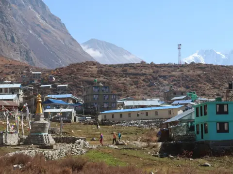
Here, tourists travel from Syabrubesi (1,550m) moving gradually upwards. They walk through Rhododendron forests during spring. They move through Tamang villages providing lodging and singing to GPS runners. The center of this trek is Kyanging Gompa (3,870m). Glaciers run across the sky with beauty. The trek can extend to Tsergo Ri (4,984m) providing fantastic pictures. This trek is of moderate difficulties and hence provides festival to every physical state. Weather during autumn offers excellent views. So, the Langtang Valley Trek maintains its ancient specialty. It symbolizes culture and Himalayan serenity.
Langtang National Park is famous for its snow-capped peaks, red panda habitat, alpine landscapes, Buddhist culture, and beautiful trekking routes near Kathmandu.
Major Attractions in Langtang Valley Trek:
Panoramic views of Langtang Lirung (7,234m) and Ganesh Himal (7,422m)
Tamang cultural experiences with traditional dances and cuisine
Red panda habitat and diverse birdlife in Langtang National Park
Ancient monasteries and yak cheese factories at Kyanjin Gompa (3,870m)
Langtang Valley Trekking Essentials:
Duration: 7–11 days round trip.
Total distance: Approximately 75–80 km.
Best seasons: March–May and September–November.
Difficulty: Moderate with gradual elevation gain.
Key Stops
Elevation (m)
Main Highlights
Syabrubesi
1,550
Roadhead, shops, trek start
Lama Hotel
2,470
Riverside rest amid forest
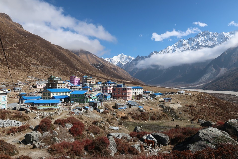
Langtang Village
3,530
Rebuilt cultural hub
Kyanjin Gompa
3,870
Monastery, cheese factory, glacier views
Historical Roots: Settlement by Ethnic Tibetans in the 15th Century
Actually, the ethnic Tibetan nomads established the Langtang Valley in the 15th century. They migrated from Tibetan territories proximate to the valley. A legend circulating among local populations substantiates the origin of the valley. A Lama chased his yak, which led him to lush grazing grounds. The valley derived its name—LANGTANG— from this incident. Over successive generations, local constituencies established Tamang settlements dedicated to Tibetan Buddhism. The economy subsidized yak grazing. Activity involving trade routes generated prosperity. Herewith, the origin of the valley affected the livelihood of subsequent denizens. Each Hanui considers the history the foundation of local culture.
Here, the union of "lang" and "tang" derived the word, Langtang. 'Lang' signified a yak; 'tang' implied "follow." Intergenerational oral traditions assimilated the story of its foundation. Residents built abodes constructed of stone and wood with intricately-carved entrances. Every monastery embodied a communal nucleus. Annual pilgrimages beckoned locals to love festivals dedicated to auspicious beings. Concomitant impacts of Tibet-centric elements reflected influences of language and print on local attire. Early settlements proliferated down stream men. The settlement story of 15th century Tibetan migrants accounted for promulgated legacy, which perpetuates the trek.
Migration and Settlement Facts in Langtang Valley:
Primary migration occurred around the 15th century from Tibet
Legend credits a Lama following his yak to the valley
Tamang people trace ancestry to Tibetan origins
Early economy relied on yak herding and cross-border trade
Cultural Heritage Markers:
Tibetan Buddhism with ancient gompas and prayer wheels
Traditional stone architecture and wooden carvings
Oral legends and songs passed through generations
Festivals blending shamanism and Buddhist rituals
Historical Period
Key Developments
Notable Sites/Elevations
15th Century
Initial settlement by Tibetans
Langtang Valley pastures
16th–18th Centuries
Village expansion, monastery construction
Kyanjin Gompa (3,870m)
Ongoing Tradition
Preservation of Tamang customs
Langtang Village (~3,530m)
Migration and Tamang Heritage: Centuries of Tibetan-Influenced Culture
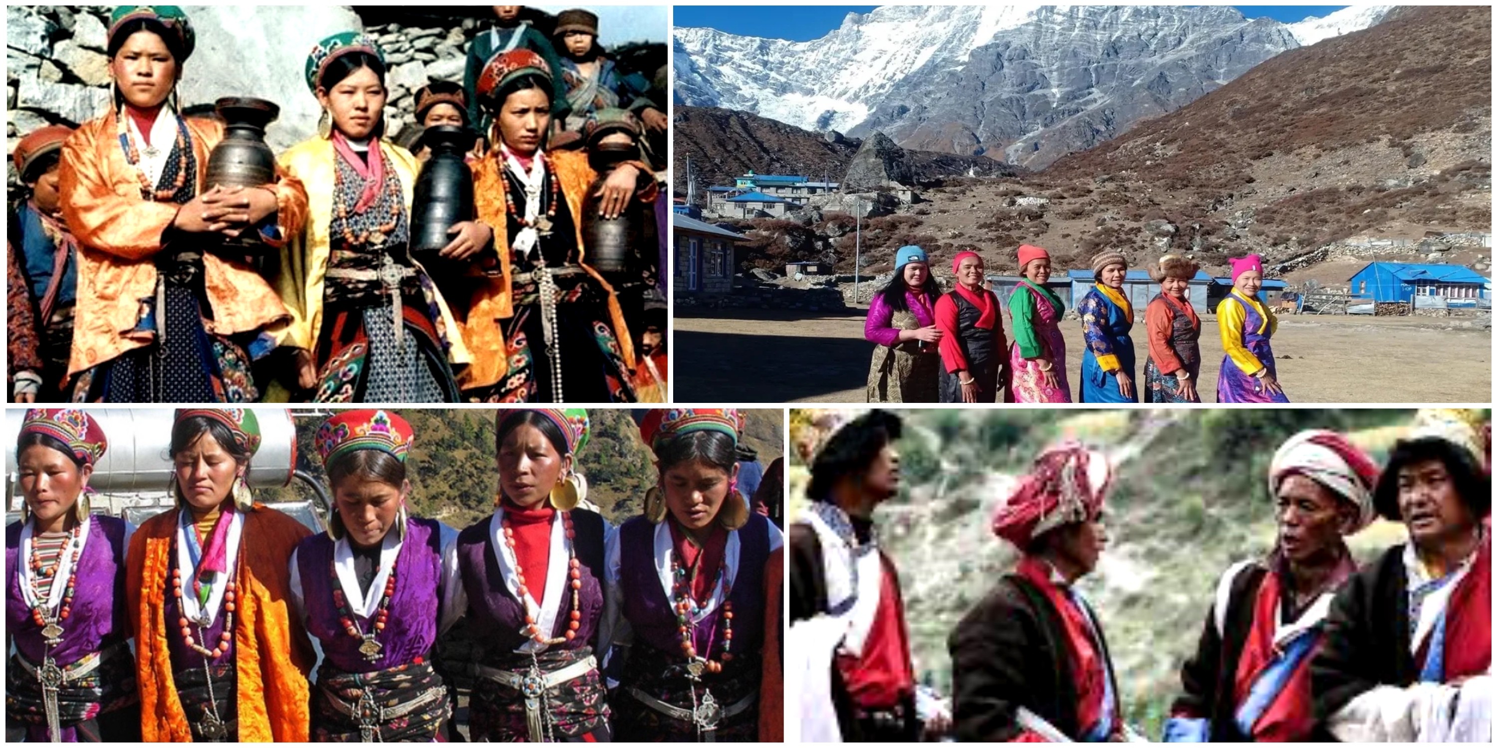
Since the beginning of the 7th century, Tamangs evolved from the first colonizers of Tibet to nomads and traders in Nepal. They integrated distinct cultural ways to survive in Himalayan landscapes. For generations, migrants founded towns and established relationships with other groups, hosting Tibetan Buddhist teachings and developing their own ways of life. Despite obstacles by terrain, Tamangs retained their shared ethic bonds. Overall, Tibetan origins gave Tamang culture highly significant elements to this nation.
Here, the origins of the Tibetan migrants enables to cherish shepherding as main occupation and integrating trade through byroads to administer their oldest way of life and preserve languages and customs from multiple origins. Although some communities faced skirmishes and unrest, a sense of stability hovered around it. The Tamang migratory experience embodies critical positions to an important share of Nepalese ethnicity.
Key Historical Migration Events in Langtang Valley:
Tamang ancestors originated in Tibet and migrated southward before the mid-1600s, seeking trade opportunities.
They arrived as horse dealers, settling in hilly areas near Kathmandu Valley (elevation around 1,400 m) and Langtang Valley (average elevation 3,000-4,000 m).
Integration with local groups occurred, blending with Sherpa and Bhotia communities in high-altitude zones.
By the 19th century, they dominated Langtang Village (3,430 m), preserving Tibetan roots amid Nepal's unification.
Cultural Elements Influenced by Tibetan Migration:
Element
Description
Elevation Context
Buddhism Practices
Tamang follow Tibetan-style rituals, including prayer flags and monasteries.
Prevalent in Kyanjin Gompa (3,870 m).
Traditional Attire
Woolen clothing and ornaments reflect Tibetan designs for cold climates.
Used in villages like Gatlang (2,200 m).
Yak Herding
Central to economy, with yaks grazed in high pastures.
Around Langtang Lirung (7,234 m) base areas.
Trade Routes
Historical paths linked Tibet to Nepal for goods exchange.
Traversed through passes near Dorje Lakpa (6,966 m).
Heritage Preservation Challenges and Efforts in Langtang Valley:
Disenfranchisement persisted historically, but community initiatives now promote cultural festivals.
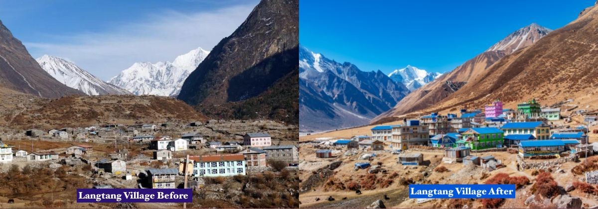
Earthquakes in 2015 destroyed sites, yet rebuilding incorporates traditional architecture in Langtang Village (3,430 m).
Language retention efforts teach Tamang dialects, derived from Tibetan, in schools.
Eco-tourism supports heritage by funding monasteries near Naya Kanga (5,846 m).
Increase in Tourism in Langtang Valley: Isolation to Trekking Destination in the 1970s
Here, tourism popularized Langtang Valley in the 1970s by attracting many visitors. Their curiosity was piqued by its natural charm and cultural richness. The adventure seekers trekked for Himalayan experiences. The locals became entrepreneurs and entrepreneurs and built up teahouses, trek guides and house rentals. This period’s economic advancement was rapid. The area lacked infrastructure initially. But the government aid hastened development. To conclude, tourism made the valley a thriving destination.
Meanwhile, the isolation of the valley ended with the footfalls in peaks and lakes. The sufficiency of protection was ensured with the start of Langtang National Park in 1976. The locals found lucrative livelihoods in hospitality sectors. This increased capital flow worldwide. Businesses flourished to survive peak visitor influx. Furthermore, cultural interactions proved rejuvenating to travelers. There were ecological issues, but the need was paramount. The communities invested to expand walkways, highways and hostels. Thus, the 1970s became a turning period for affluence.
Major Tourism Milestones in the 1970s:
Discovery of Langtang Village (3,430 m) in early 1970s drew initial trekkers, increasing revenue.
National Park creation in 1976 protected biodiversity, attracting 20,000 annual visitors by late decade.
Hippie influx from broader Nepal tourism influenced early cultural tourism.
Teahouses emerged in settlements like Kyanjin Gompa (3,870 m), supporting local economies.
Economic Impacts on Key Settlements:
Settlement
Elevation
Tourism Boost | Opportunities Created
Langtang Village
3,430 m
Attracted hikers to glacial lakes | Guiding, lodging for residents.
Syabrubesi
1,460 m
Gateway for treks | Transport and supply jobs.
Kyanjin Gompa
3,870 m
Views of Langtang Lirung (7,234 m) | Cheese factories, homestays.
Lama Hotel
2,470 m
Midway rest point | Teahouse operations.
Post-1970s Developments and Challenges:
Became third most popular trekking area in Nepal by 1980s.
2015 earthquake disrupted, but recovery emphasized sustainable tourism.
Dark tourism emerged post-disaster, blending adventure with history.
Infrastructure improvements, like roads, enhanced access near Ganesh Himal (7,422 m).
The establishment of Langtang National Park in 1976
Actually, Langtang National Park was set up by the government of Nepal in 1976. This was the country's first national park located in the Himalayas. The authorities wanted to protect the area's special flora, fauna and landscape. The park covers 1,710 sq km area within Rasuwa, Nuwakot, and Sindhupalchok districts. The park incorporates a number of varied habitats from subtropical forests to meadows at high altitudes, and carries out conservation measures to protect endangered species and their habitats. Despite the concentration of nature, there is still the problem of human-wildlife confrontation. To sum up, this was the creation of the authentic protector of Nepal's natural treasures.
Meanwhile, the government gazette the park officially during the year 1976. It added an area of 420 sq km as buffer zone in 1998. This declared buffer zone involves local people in the management of the park and the local people are permitted to use the park for gaining benefit. In addition to this, the official declaration of buffer zone brought the trekking routes under the official umbrella to encourage eco-tourism. The rangers patrol the park to conserve their flora and fauna. Therefore, it is a success to prevent the destruction of nature by involving local people and official governance.
Key Facts on Establishment and Area:
Established: 1976 as Nepal's first Himalayan national park and fourth protected area overall.
Himalayan monal in higher forests and alpine areas (~3,000-4,500 m); over 250 bird species total.
Flora
Rhododendron, oak, pine, fir, juniper, blue poppy, medicinal herbs
Subtropical sal/oak at low elevations; subalpine rhododendron/fir up to 4,000 m; alpine herbs near glaciers.
Conservation and Management Aspects:
Protects 46 mammal species and over 1,000 plant species.
Community involvement through buffer zone reduces poaching and supports livelihoods.
Formalized trails prevent habitat damage from unregulated trekking.
Post-2015 earthquake recovery integrated sustainable practices in affected areas like Langtang Valley.
The official trekking gateway of Langtang Valley Trek: Syabrubesi as the Starting Point
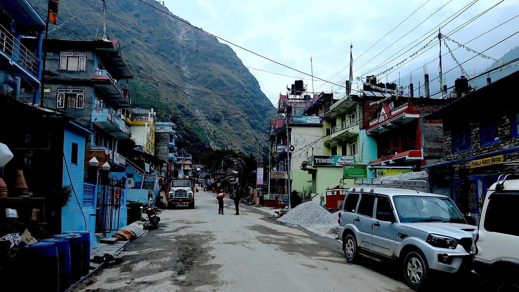
Actually, Syabrubesi is the official trailhead in the Langtang Valley trekking. It is basically an accessible place by road from Kathmandu. It has a comfortable elevation at 1460-1550 meters. It is the starting point of the picturesque and easy 77 km track. The trekking route travels through woods, rivers, and Tamang settlements; furthermore, the way rises steadily to high altitudes. It has the disadvantages of a rough and bumpy ride in the beginning; however, the gateway has all the basic facilities. To sum up, Syabrubesi triggers amazing Himalayan adventures with the perfect reliability.
Likewise, the trekkers move away from Syabrubesi toward Kyanjin Gompa at 3,860-3,870 meters. It outlines a course of 65-77 km trip in total size. It escorts most various terrains and cultural encounters. The villagers offer teahouses and guidance during the travel. Additionally, it crosses using suspension bridges and yak meadows. The route arrives to the Langtang Village at 3,430 meters at the half way point. Summarizing, the gateway designs a protecting and enjoyable trip adequately.
Langtang Valley Trek Route Overview from Syabrubesi:
Starting point: Syabrubesi (1,460-1,550 m), 120-140 km from Kathmandu (7-9 hours by bus/jeep).
Total trek distance: Approximately 65-77 km round trip to Kyanjin Gompa and back.
Key segments: Syabrubesi to Lama Hotel (~11 km, 6-7 hrs, +1,000 m); Lama Hotel to Langtang Village (~11-14 km, 6-7 hrs, +800 m); Langtang Village to Kyanjin Gompa (~7-10 km, 3-4 hrs, +400-500 m).
Highest point: Kyanjin Gompa (3,860-3,870 m), with optional side hikes to viewpoints over 4,000 m.
Difficulty: Moderate, with steady ascents through forests and valleys.
Major Stops and Elevations Along the Trail:
Stop
Elevation
Distance from Previous | Key Features
Syabrubesi
1,460-1,550 m
Starting point | Roadhead town, shops, teahouses, Bhote Koshi River views.
Lama Hotel
2,410-2,470 m
11 km | Midway rest, bamboo forests, riverside setting.
Langtang Village
3,430 m
11-14 km | Historic Tamang settlement, rebuilt post-2015 earthquake, monasteries.
Kyanjin Gompa
3,860-3,870 m
7-10 km | Ancient monastery, cheese factory, views of Langtang Lirung (7,234 m) and glaciers.
Practical Details for Trekkers:
Travel from Kathmandu: 122-140 km drive, often bumpy in upper sections.
Permits required: Langtang National Park entry and TIMS card at Syabrubesi checkpoint.
Best seasons: Spring (March-May) for rhododendrons; autumn (September-November) for clear views.
Accommodation: Teahouses throughout, with basic facilities up to Kyanjin Gompa.
The 2015 Earthquake in Nepal: Avalanche and destruction
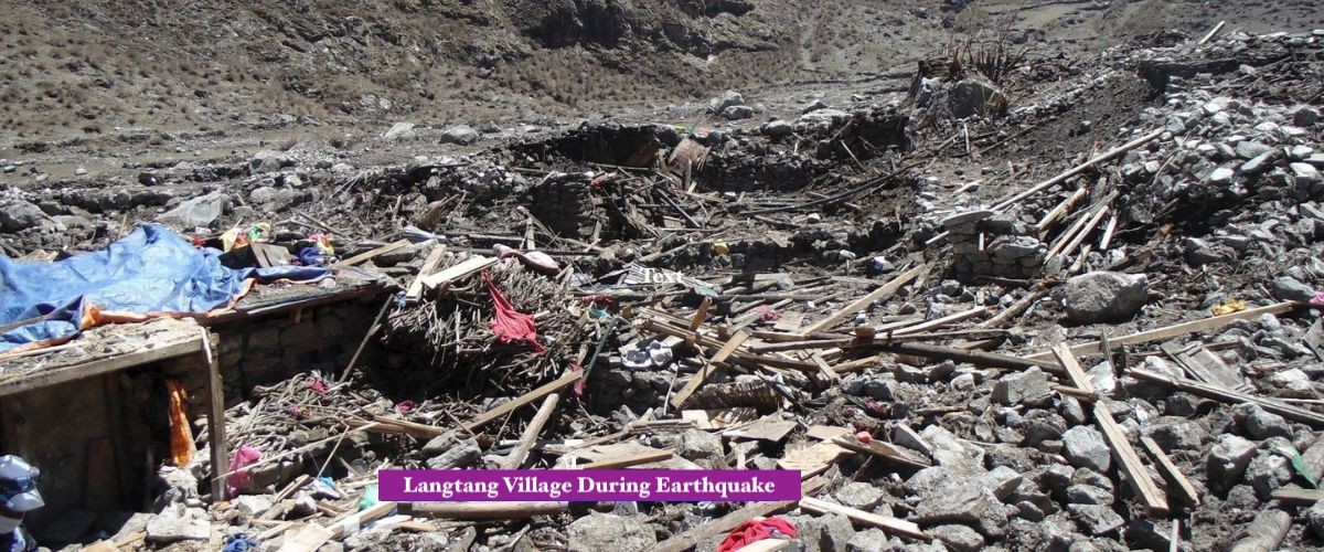
On the 25 th April 2015 at 11.56 (local time) a strong 7.8 magnitude earthquake was experienced in Nepal. As a result Langtang Valley experienced a high magnitude ice/rock avalanche, causing the complete destruction of Langtang Village (3,430 m). It triggered massive debris release from Langtang Lirung (7,234 m), estimated at 40 million tons. Large sections of trees were flattened across the valley by powerful air blast waves. The day after the event, survivors found itself placed in chaos, debris, destruction and death. This uncontrolled event represented one of Nepal's greatest individual earthquake losses. Overall, this event razed the village to ground level and permanently changed the surrounding landscape.
Actually, the avalanche instantly killed hundreds of people. Overall Langtang experienced the devastation of 243-310 deaths, consisting of 175-176 locals, 41 foreign individuals and local staff members. A further 100+ decomposing bodies were yet to be recovered from beneath debris piles. Elsewhere in Nepal nearly 9,000 total deaths were experienced. However, Langtang derived an overwhelming impact due to its proximity to the epicenter. Ultimately, the event exemplified the dangers associated with high Himal range settlements.
Key Details of the 2015 Earthquake and Avalanche:
Date and magnitude: April 25, 2015; 7.8 Mw, epicenter in Gorkha district.
Avalanche trigger: Collapse from south face of Langtang Lirung (7,234 m), including glacier and frozen lake.
Debris volume: Estimated 40 million tons of rock, ice, and boulders.
Impact on Langtang Village (3,430 m): Completely buried; only one house survived under rock face.
Air blast effects: Flattened forests and structures for kilometers downstream.
Casualty Breakdown in Langtang Valley:
Category
Estimated Numbers
Notes
Total deaths in Langtang
243-310
Varies by source; often cited as 243 (175 locals + 27 staff + 41 foreigners).
Local residents (Tamang)
175-176
Primary community affected at Langtang Village (3,430 m).
Foreign trekkers/tourists
41-80
Including various nationalities on the trail.
Other (guides, porters, army)
10-27
Rescue personnel and local staff included in some counts.
Unrecovered bodies
Over 100
Remains buried under massive debris field.
Broader National and Regional Impacts:
National death toll: Approximately 8,900-9,000 across Nepal.
Injuries: Over 22,000 reported nationwide.
Related events: Avalanche at Everest Base Camp killed 19-22 climbers.
Economic loss: Billions in damage, including heritage sites and infrastructure.
Immediate Aftermath: Loss and Initial Recovery Efforts in Langtang Valley
Here, the earthquake in 2015 destroyed numerous settlements in the Langtang Valley. Instantaneously, the survivors lost their homes, relatives, and means of financial support. Tourism (public accesses) came to a complete standstill after the tragedy, and those who were displaced evacuated from the Langtang Valley to more stable areas such as Kathmandu.
Furthermore, paths became obstructed with rubble and mud, and the people in the country had to suffer with their losses and a lot of uncertainty, but the people soon banded together and money was made available by the international community to aid relief work. Overall, the aftermath of the tragedy was devastating, but it provoked a focus of resolute recovery.
Actually, the rebuilding started with community initiated projects. The survivors began to put the nation back together, by bulldozing paths and helping to resurrect the victims. Aid began to be delivered to secluded areas of the country via helicopter, and campaigns began to help distribute mass amounts of supplies. Nevertheless, people continued to struggle with their mental health and tourism stayed dormant for a time. The nation's focus turned towards rebuilding in a sustainable and responsible way. Thus, the recovery turned a forced tragedy, into a resilient nation. Langtang Valley is safe to travel after the earthquake 2015.
Infrastructure damage: Teahouses, trails, and bridges ruined by avalanche debris.
Ongoing issues: Mental scars, incomplete recoveries, and fear of future disasters.
Initial Recovery Efforts and Support:
Effort/Organization
Description
Timeline/Impact
Community unity
Locals formed committees for rescue and rebuilding.
Immediate; led to grassroots reconstruction.
Helicopter rescues
Government and international teams airlifted survivors and supplies.
Days after quake; reached isolated Langtang areas.
International aid
NGOs like Samaritan's Purse, Trek Relief provided shelter and funds.
2015 onward; rebuilt homes and schools.
Trail clearing
Volunteers and locals reopened paths gradually.
2016-2017; enabled tourism restart.
Memorials
Plaques and mani walls honored victims near old village site.
Post-2015; preserved mem
Longer-Term Rebuilding Milestones:
New village construction: Relocated slightly higher/safer; teahouses rebuilt with modern amenities.
Tourism revival: Routes reopened by 2017; visitors returned, supporting economy.
School reconstruction: Komin Shyamey Wangphel Secondary School rebuilt with donations.
Community organizations: Langtang Management Committee raised funds independently.
Challenges: Heavy tourism dependence; limited healthcare facilities persist.
Reopening and Rebuilding of Langtang Trail: Trails Restored by 2017
Meanwhile, communities Reopened Langtang Valley trails by 2017. The villagers rebuilt the paths with stone steps and strengthened bridges. Railings were built on the canyons and bridges to ensure the safety of the trekkers. The villages were rebuilt with home and teahouses which were strong against earthquakes.
Moreover, the villages such as Langtang Village (3,530 M) shifted to higher elevation which was 100 m above the existing one for safety reasons. Schools and gompas also started to operate. The aid from foreign countries helped the local in rebuilding. The result was positive in the aspect of resilience and retrieving the access.
Likewise, the Langtang valley was rebuilt after it was devastated. The survivors moved the debris and diverted the way through trail. The new design was 20-40% stronger than that of current design. The teahouses were reopened with modern facilities. Memorials were built near former sites to commemorate the victims. Also, the tourism was gradually resumed. Therefore, the year of 2017 marked the great comeback of the life in the Himalaya and its trail.
Current Tourism Statistics in Langtang Region (Recent Data):
Visitor numbers: Over 42,000 tourists (domestic + international) visited Gosainkunda and Langtang regions in 11 months of 2025 (e.g., mid-July 2024 to mid-June 2025).
Recent surge: 32,671 visitors from mid-July 2025 to mid-January 2026 in Rasuwa areas.
Broader Nepal: 1,158,459 international arrivals in 2025; Langtang remains popular for accessibility.
Recovery trend: Steady growth post-COVID; Langtang sees increased domestic (e.g., 30,750 Nepali in one period) and foreign visitors.
Modern Amenities and Regulations in 2026:
Amenity/Regulation
Details
Locations/Elevation Notes
Teahouses
Offer WiFi, solar hot showers, stable rooms; basic to mid-range.
Widespread: Syabrubesi (1,460 m) to Kyanjin Gompa (3,870 m).
Yak cheese factories
Operational in Kyanjin Gompa; local product sales.
Kyanjin Gompa (3,870 m); supports economy.
Licensed guides
Mandatory since 2023/2025; all trekkers require registered guide.
Enforced in Langtang National Park; enhances safety and jobs.
Safety features
Earthquake-resistant builds; well-maintained trails with railings.
Villages like Langtang (~3,530 m); near Langtang Lirung (7,234 m).
Ongoing Developments and Attractions in Langtang Valley:
Accessibility: Roads to Syabrubesi improved; permits via TAAN or agencies.
Best seasons: Spring/autumn for clear views; rhododendrons bloom.
Community benefits: Tourism revenue aids livelihoods; sustainable practices emphasized.
Visitor appeal: Less crowded than Everest/Annapurna; cultural Tamang experiences.
Future Infrastructure: Potential Road Extensions and Accessibility in Langtang Valley
Here, authorities are constructing new roads in Langtang Valley to facilitate access. They are also studying road pathways between populated areas of south Rasuwa to minimize journeys from Kathmandu. This will lead to more manageable starts to treks. Furthermore, upgrading projects include renovations to the Rasuwa district. Developed hydropower stations are situated along the Langtang River, necessitating road extensions to places like Sherpagoan. Despite, obstacles such as ecosystem disruption, construction has been postponed. Ultimately, improving infrastructure offers the benefits of raising living standards and permeability.
Likewise, infrastructure development emphasizes Rasuwa's improved connectivity. This involves extending existing roads, lessening trek initiations by a day in certain sections. Upgrading plans focus on Syabrubesi-Rasuwagadhi route for improved flow of traffic in both directions. Furthermore, construction of new hydropower stations induces infrastructure alterations. These benefit communities with freedom of movement to reach Langtang Village (~3,530 m). Hence, improved accessibility is in close harmony with the environmental priorities.
Current and Planned Road Developments in Rasuwa/Langtang Area:
Syabrubesi-Rasuwagadhi upgrade: 15.5 km to two-lane road with Chinese assistance; construction set to start February 2026 after delays.
Road extension to Sherpagoan: Shortens traditional trekking route by a full day; linked to hydropower projects along Langtang River.
Kathmandu to Rasuwagadhi connectivity: MoU for 50 km road with tunnels (Tokha-Chhahare and Mailung-Syabrubesi); feasibility ongoing, potential start in coming years.
General Rasuwa improvements: Focus on widening and restoration post-floods/landslides; aims to boost trade and tourism access to Syabrubesi (1,460-1,550 m).
Impacts on Trekking Accessibility:
Aspect
Details
Elevation/Location Notes
Current start
Drive to Syabrubesi (1,460-1,550 m); 6-9 hours from Kathmandu (1,400 m).
Gateway remains road-accessible; bumpy in sections.
Potential shortening
Road extensions reduce trek start; e.g., to Sherpagoan shortens by 1 day.
Affects lower valley access near Langtang Lirung (7,234 m) base.
Benefits
Faster access, less reliance on long drives; supports tourism recovery.
Easier for visitors to reach Kyanjin Gompa (3,870 m).
Challenges
Environmental objections in Langtang National Park; landslide risks.
Delays from clearances and natural disasters.
Future Considerations:
Hydropower-driven roads: 20 MW plant in final stages influences extensions.
Trade corridor focus: Upgrades prioritize Nepal-China border access over valley interior.
Trekker reports: Note surveys for potential valley road construction to improve access.
Sustainable Development: Focus on Climate Monitoring and Eco-Tourism
In Langtang Valley, Nepal has high sustainable development priorities. The region's focus is on climate watching through monitoring glaciers during climate change. The authorities have adopted eco-tourism to save the region's biodiversity. Moreover, glacier retreat projects such as planting trees and reducing wastes are undertaken. The community keeps control of climatic risks. But, the loss of glaciers has bear consequences for the lower water accessibility. In conclusion, these projects are undertaken to lessen the damage to fragile Himalayan ecology.
Here, stakeholders are involved in climate-proofed approaches. The glaciers and the glacial lakes are watched down to avoid their possible bursts. The eco-tourism initiatives have been taken to encourage that mindfull behavior of trekking. Furthermore, the deforestation has been combated and the wise land uses approaches been adopted. The community involvement have given strength to adaptation policies. Hence, these adaptation projects have ensured the sustainable future and maximized the return.
Climate Change Impacts and Monitoring in Langtang:
Glacier retreat: Rapid melting in Langtang Valley; Yala Glacier loses >1 m ice/year; concerns for water scarcity and GLOF risks.
Glacial lake risks: Expanding lakes increase GLOF potential; national efforts monitor high-risk lakes (though not specific to Langtang, regional focus applies).
Fieldwork and studies: 2024-2025 expeditions monitor glaciers; use satellite imagery, AWS for real-time data on temperature, precipitation.
Broader HKH trends: Glaciers melt 65% faster 2011-2020; Nepal lost ~25% glacier area 1980-2010.
Sustainable Practices and Eco-Tourism Initiatives:
Practice
Description
Location/Notes
Glacial monitoring
Ongoing expeditions; satellite/remote sensing for lake changes and hazards.
Langtang Valley glaciers near Langtang Lirung (7,234 m); supports GLOF early warnings.
Tree planting/reforestation
Drone seeding and community efforts restore degraded areas.
Targeted at high-altitude zones; combats climate impacts.
Waste reduction
Responsible trekking: Minimize single-use plastics, Leave No Trace principles.
Teahouses from Syabrubesi (1,460 m) to Kyanjin Gompa (3,870 m).
Eco-tourism promotion
Educate visitors on conservation; support local livelihoods via sustainable tourism.
Langtang National Park; emphasizes biodiversity protection.
Community adaptation: Balance development with preservation; address hydropower and tourism pressures.
Policy focus: Integrate monitoring into national plans; promote gender-responsive resilience.
Updated Regulations for Langtang Valley Trek: Compulsory Guides & Improved Safety in 2026–2027
Here, stricter regulations apply to trekking in the Langtang Valley in 2026-2027. Guides with licenses are compulsory for foreign trekkers. This legislation supports safety and local economies. Better-maintained corridors include secured infrastructure. Local community supported-run projects encourage sustainable forms of tourism. However, monitoring of these new guidelines is intensive. Overall, the Trek gets easier and safer and supports local resilience.
Officially, regulations assume the mandatory policy of guides from 2023. Trekkers employ licensed professionals from agencies. Deteriorated pathways help minimize the risks inherent in the risks of landslides and altitude sickness. Moreover, security protocols demand safety awareness training for guides. Local communities obtains profits through guiding opportunities. So, progressive processes strengthen tourist accommodation and safeguard regularly.
Key Regulations in 2026-2027:
Mandatory licensed guide: Required for all foreign trekkers in Langtang National Park since 2023, strictly enforced in 2026-2027 by Nepal Tourism Board (NTB) and TAAN.
No solo trekking: Foreign nationals prohibited from independent trekking; must join organized groups or hire guides.
Permits required: Langtang National Park Entry Permit (NPR 3,000 for foreigners) remains essential; TIMS card phased out in some updates but agency support needed.
Safety enhancements: Guides trained in first aid, altitude sickness recognition, and emergency evacuation.
Safety and Trail Improvements:
Aspect
Details
Location/Elevation Notes
Guide Role
Provide navigation, cultural insights, and risk management.
Throughout trail from Syabrubesi (1,460-1,550 m) to Kyanjin Gompa (3,870 m).
Trail Maintenance
Reinforced bridges, railings, and stone stairs added post-2015.
Key sections near Langtang Village (~3,530 m) and Langtang Lirung (7,234 m) base.
Community Initiatives
Locals lead waste management and trail upkeep for sustainability.
Checks at entry points like Syabrubesi checkpoint.
Ensures compliance; boosts local jobs in guiding.
Benefits to Local Resilience and Tourism:
Economic boost: Guiding creates jobs for Tamang communities; tourism revenue aids recovery.
Enhanced safety: Reduces accidents; guides assist in emergencies near high elevations.
Sustainable practices: Regulations promote eco-friendly trekking and cultural respect.
Lessons from Resilience: The Langtang Valley's Enduring Spirit
Actually, Langtang Valley's illustrate resilience resulting from adaptability. Native Tamang dwellings have known generations of adversity. The 2015 earthquake annihilated local populations with wrenching devastation. Concise fact, survivors revitalized their settled villages with unrelenting resolve. Further, cultural values thrived in tandem with livelihoods. Tourism facilitated ongoing revitalization efforts. To sum up, the valley inhales observer inspiration across the globe.
Likewise, the Tamang inhabits embodies strength in adversity. Where once settled, they relocated settlements for safety. They recreated traditional abodes and gompas. Values like Buddhist services thrive lively. In addition, memorials commemorate those who have died in proximity to former sites of residence. Trekking animates economy and culture. Therefore, Langtang Institute of Lessons in the face of adversity.
Historical and Post-Disaster Transformation:
Ancient roots: Tamang migrants from Tibet established pastoral life centuries ago.
Tourism jobs in guiding, teahouses support livelihoods.
From Syabrubesi (1,460 m) to high pastures near Langtang Lirung (7,234 m).
Memorial Efforts
Sites honor victims; prayer walls and butter lamps maintained.
Near old village ruins at 3,430 m.
Lessons from the Langtang Valley's Spirit:
Resilience through unity: Tamang people rebuilt stronger after tragedy.
Cultural role of trekking: Visitors experience and support heritage preservation.
Inspiration for future: Valley symbolizes hope, adaptation, and enduring Himalayan spirit.
Conclusion: Langtang Valley Trek for the Ages – Past Echoes, Present Vitality, Future Promise
Here, Langtang Valley Trek symbolizes the ageless Himalayan traditions of Nepal. Long-standing Tamang migration has defined its Buddhist practices over centuries. The valley experienced impenetrable solitude before opening to trekkers in the 1970s. Disasters occurred in 2015, yet new communities naturally revitalized. Trail restoration and upgrades calling for devotees combine safety and eco-friendliness. Conclusively, Langtang reflects a resilient, fascinating, and breathtaking homeland.
Likewise, hikers during Langtang Valley Trek have a lot to learn about unique cultural diversity. They observe Tibetan cults at gompas in Kyanjin Gompa (3,870 m). Breathtaking panoramas of Langtang Lirung (7,234 m) overwhelm their eyes. Environmentally sustainable tourism allows local Tamang families to uphold their culture. New plans are under development to provide sheltered yet accessible tourism to villagers while conserving the delicate environment. Thus, trek binds histories and cultures to modern values and prospects. Tourist earnings are crucial to its ongoing appeal.
Past Echoes: Historical and Cultural Foundations
Tamang migration from Tibet since 7th century established yak herding and trade.
Tibetan Buddhism integrated deeply; monasteries and prayer flags define villages.
Langtang National Park (1976) preserved biodiversity across 1,710 sq km.
Pre-2015 era: Third most popular trek in Nepal; isolation ended with tourism boom.
Present Vitality: Current State and Visitor Experience:
Aspect
Details
Elevation/Location Notes
Trail Status
Fully restored; stone stairs, railings, reinforced bridges.
From Syabrubesi (1,460-1,550 m) to Kyanjin Gompa (3,870 m).
Amenities
WiFi, hot showers, yak cheese factories in teahouses.
Langtang Village (~3,530 m), Kyanjin Gompa (3,870 m).
Visitor Numbers
Over 42,000 in recent periods (mid-2025 data); steady growth.
Rasuwa district including Langtang Valley.
Safety Measures
Mandatory licensed guides since 2023; community-led upkeep.
Enforced throughout national park trails.
Cultural Immersion
Tamang homestays, festivals, rebuilt gompas.
Villages showcase resilient heritage.
Future Promise: Sustainability and Ongoing Evolution:
Eco-tourism focus: Waste reduction, tree planting, responsible trekking guidelines.
Infrastructure plans: Potential road extensions to Sherpagoan; shorter access from Kathmandu.
Community benefits: Tourism revenue funds education, health, and cultural preservation.
Invitation to adventurers: Experience beauty while supporting sustainable future practices.
FAQS:Langtang Valley Trek-Past, Present and Future
1. What is the Langtang Valley Trek?
The Langtang Valley Trek is an adventure in the Himalayas. It starts from Syabrubesi. Goes all the way to Kyanjin Gompa. You get to see the Langtang Lirung mountain and learn about the Tamang people and their culture. The Langtang Valley Trek shows you the past, the present and the future of the valley.
2. What are the historical roots of Langtang Valley?
A time ago in the 15th century people from Tibet came to live in the Langtang Valley. They crossed mountains and made villages. This is how the Tamang culture started in the Langtang Valley. The Tamang people still live in the Langtang Valley today.
3. Who are the Tamang people in Langtang Valley?
The Tamang people are the people who live in the Langtang Valley. They have a connection to Tibet and its culture. You can see this in their language their monasteries and the way they live. The Tamang people have an unique culture that is worth learning about.
4. When did tourism begin in Langtang Valley?
Tourism in the Langtang Valley started to grow in the 1970s. Before that the Langtang Valley was an isolated place. Then people started to come and trek in the valley. This is when the Langtang Valley became a place for trekking.
5. When was Langtang National Park established?
Langtang National Park was made in 1976. It was the national park in the Himalayas in Nepal. The park was made to protect the animals the plants and the culture of the Langtang Valley. It also helps to promote tourism in a way that's good for the environment.
6. Where does the Langtang Valley Trek officially start?
The Langtang Valley Trek starts in a town called Syabrubesi. Syabrubesi is 7-8 hours’ drive from Kathmandu. It is a town where people start their trek to the Langtang Valley.
7. How did the 2015 earthquake affect Langtang Valley?
The earthquake in 2015 was very bad for the Langtang Valley. It caused an avalanche that destroyed the Langtang Village. Many people, both locals and trekkers lost their lives. It was a sad time for the valley.
8. What happened in Langtang Valley after the 2015 earthquake?
After the earthquake the people who survived had to deal with a lot of loss. The first thing that needed to be done was to rescue people provide relief and help them rebuild their lives. The trail was. The community was mourning and trying to heal.
9. When did the Langtang Valley Trek reopen after the earthquake?
The trails and teahouses were. The Langtang Valley Trek was officially open again by 2017. The local communities worked hard to rebuild the trekking infrastructure.
10. What is the current status of the Langtang Valley Trek?
Today the Langtang Valley Trek is fully open and ready for visitors. The trails are better. There are more teahouses and facilities. It is a place to visit because of its natural beauty, culture and the story of how the community recovered from the earthquake.
11. What future infrastructure developments are planned for Langtang Valley?
There are plans to make it easier for people to visit the Langtang Valley by building roads. This needs to be done in a way that does not harm the environment. The goal is to have more tourists visit in a way.
12. How is sustainable tourism being promoted in Langtang Valley?
The focus is on eco-tourism monitoring the climate managing waste and involving the community. The goal is to protect the environment and support the Tamang people for a long time.
13. Are guides compulsory for the Langtang Valley Trek?
Yes, from on you will need to have a licensed guide to trek in the Langtang Valley. This is for safety. To help the local community. It will also make the experience better for visitors.
14. Why is Langtang Valley Trek considering a story of resilience?
The Langtang Valley Trek is a story of hope and recovery. After the big earthquake in 2015 the valley was able to recover. This shows the spirit of the Tamang people.
15. How long does the Langtang Valley Trek take?
The standard Langtang Valley Trek takes about 7 to 10 days. This includes visiting places like Kyanjin Ri or Tserko Ri. It is a trek for both beginners and experienced trekkers.
16. What makes Langtang Valley Trek different from other treks?
The Langtang Valley Trek is special because it is not as crowded as treks. You can really experience the trails the authentic Tamang culture and the beautiful mountain views. It is a mix of the past, present and future.
17. Is Langtang Valley Trek suitable for beginners?
Yes, the Langtang Valley Trek is good for beginners. It is not too hard. The trails are well marked. You can also stay in teahouses, which makes it easier.
18. What can I learn from the history of Langtang Valley?
When you visit the Langtang Valley you can learn a lot about how strong people can be, how important it is to preserve culture and how communities can work together. The valleys history is connected from the century to the present day.
19. What is the best time to do the Langtang Valley Trek?
The best times to visit are in the spring (March to May). Autumn (September to November). The weather is nice. You can see beautiful flowers or golden landscapes.
20. Why should I choose the Langtang Valley Trek now?
You should choose the Langtang Valley Trek now because it is a living story of recovery. You will be supporting the community and you will experience one of the most authentic valleys, in the Himalayas. It has a past, a vibrant present and a hopeful future.