[{"name":"Everest Base Camp Helicopter Tour","duration":"1","image_url":"https:\/\/www.havenholidaysnepal.com\/storage\/trip-galleries\/1\/thumb_6cd53005d75a86e373d31419d1b14d78.webp","offer_price":1195,"url":"https:\/\/www.havenholidaysnepal.com\/trips\/everest-base-camp-helicopter-tour"},{"name":"Everest Mountain Flight","duration":"1","image_url":"https:\/\/www.havenholidaysnepal.com\/storage\/trip-galleries\/4\/thumb_3b0b4f1d6f72b0ad224daf4752f2c6e0.jpg","offer_price":285,"url":"https:\/\/www.havenholidaysnepal.com\/trips\/everest-mountain-flight"},{"name":"Everest Short Trek","duration":"9","image_url":"https:\/\/www.havenholidaysnepal.com\/storage\/trip-galleries\/5\/thumb_BXPP3621.JPEG0.02033800 1727957098.webp","offer_price":995,"url":"https:\/\/www.havenholidaysnepal.com\/trips\/everest-short-trek"},{"name":"Gokyo Valley Trek","duration":"12","image_url":"https:\/\/www.havenholidaysnepal.com\/storage\/trip-galleries\/6\/thumb_10bc469b14731f23d3ce84a7092ad53f.jpg","offer_price":1195,"url":"https:\/\/www.havenholidaysnepal.com\/trips\/gokyo-valley-trek"},{"name":"15 days Annapurna Base Camp Trek","duration":"15","image_url":"https:\/\/www.havenholidaysnepal.com\/storage\/trip-galleries\/7\/thumb_87d1533bc45faf070990aef0579e4be4.jpg0.81855100 1728285496.webp","offer_price":785,"url":"https:\/\/www.havenholidaysnepal.com\/trips\/15-days-annapurna-base-camp-trek"},{"name":"Nepal Pilgrimage Tour","duration":"14","image_url":"https:\/\/www.havenholidaysnepal.com\/storage\/trip-galleries\/8\/thumb_02c3bcf2ad2e8a4c1703e90ae747b5f1.jpg","offer_price":1475,"url":"https:\/\/www.havenholidaysnepal.com\/trips\/nepal-pilgrimage-tour"},{"name":"UNESCO World Heritage Site Tour","duration":"10","image_url":"https:\/\/www.havenholidaysnepal.com\/storage\/trip-galleries\/9\/thumb_unesco-world-heritage-site-Lumbani-temple-buddhists-hindus-kathmandu-nepal0.36988600 17347617740.93089500 1737469667.webp","offer_price":715,"url":"https:\/\/www.havenholidaysnepal.com\/trips\/unesco-world-heritage-site-tour"},{"name":"Island Peak Climbing","duration":"16","image_url":"https:\/\/www.havenholidaysnepal.com\/storage\/trip-galleries\/11\/thumb_Island peak0.53947000 1734692503.webp","offer_price":2495,"url":"https:\/\/www.havenholidaysnepal.com\/trips\/island-peak-climbing"},{"name":"Upper Mustang Trek","duration":"18","image_url":"https:\/\/www.havenholidaysnepal.com\/storage\/trip-galleries\/12\/thumb_upper mustang 7 Oct-2024.jpg0.95398900 1728286166.webp","offer_price":2995,"url":"https:\/\/www.havenholidaysnepal.com\/trips\/upper-mustang-trek"},{"name":"Annapurna Circuit Trek","duration":"16","image_url":"https:\/\/www.havenholidaysnepal.com\/storage\/trip-galleries\/15\/thumb_tibetan-flags.jpg0.04843900 1728289138.webp","offer_price":985,"url":"https:\/\/www.havenholidaysnepal.com\/trips\/annapurna-circuit-trek"},{"name":"Gosainkunda Lake Trek","duration":"10","image_url":"https:\/\/www.havenholidaysnepal.com\/storage\/trip-galleries\/16\/thumb_5A8083B3-C007-41A8-853F-D0C37C97D235_1_105_c.jpeg0.52581200 1731845258.webp","offer_price":595,"url":"https:\/\/www.havenholidaysnepal.com\/trips\/gosainkunda-lake-trek"},{"name":"Zip-lining in Pokhara and Dhulikhel","duration":"1","image_url":"https:\/\/www.havenholidaysnepal.com\/storage\/trip-galleries\/18\/thumb_215f765e2ebc995dd5c800b4bfdbacc3.jpg","offer_price":82,"url":"https:\/\/www.havenholidaysnepal.com\/trips\/zip-lining-in-pokhara-and-dhulikhel"},{"name":"Annapurna Heli Tour","duration":"1","image_url":"https:\/\/www.havenholidaysnepal.com\/storage\/trip-galleries\/19\/thumb_d71a6bbb9fd4da8d1b567a5cdbdec85d.jpg","offer_price":555,"url":"https:\/\/www.havenholidaysnepal.com\/trips\/annapurna-heli-tour"},{"name":"Paragliding in Pokhara","duration":"1","image_url":"https:\/\/www.havenholidaysnepal.com\/storage\/trip-galleries\/20\/thumb_de788d2dd9726783431f882c007efae1.jpg","offer_price":65,"url":"https:\/\/www.havenholidaysnepal.com\/trips\/paragliding-in-pokhara"},{"name":"Ultra-Flight in Pokhara","duration":"1","image_url":"https:\/\/www.havenholidaysnepal.com\/storage\/trip-galleries\/21\/thumb_e27a9fb572a5c21611bb2a3c18e4b8f0.jpeg","offer_price":175,"url":"https:\/\/www.havenholidaysnepal.com\/trips\/ultra-flight-in-pokhara"},{"name":"Sarangkot Hiking","duration":"1","image_url":"https:\/\/www.havenholidaysnepal.com\/storage\/trip-galleries\/22\/thumb_100ef822fea19987166c6c1366215f15.jpg","offer_price":55,"url":"https:\/\/www.havenholidaysnepal.com\/trips\/sarangkot-hiking"},{"name":"Mera Peak Climbing","duration":"18","image_url":"https:\/\/www.havenholidaysnepal.com\/storage\/trip-galleries\/24\/thumb_d16ae3895f678cf26ffbf2455f541fb5.jpg0.31883400 1732617790.webp","offer_price":2475,"url":"https:\/\/www.havenholidaysnepal.com\/trips\/mera-peak-climbing"},{"name":"Lower Dolpo Trek","duration":"18","image_url":"https:\/\/www.havenholidaysnepal.com\/storage\/trip-galleries\/26\/thumb_Dolpo Galary - 1.JPG0.37725200 1727939952.webp","offer_price":2995,"url":"https:\/\/www.havenholidaysnepal.com\/trips\/lower-dolpo-trek"},{"name":"Nagarkot Sunrise\/Sunset Tour","duration":"1","image_url":"https:\/\/www.havenholidaysnepal.com\/storage\/trip-galleries\/27\/thumb_5147a5532644283a380f2e86f3857c13.jpg0.17748000 1728488108.webp","offer_price":30,"url":"https:\/\/www.havenholidaysnepal.com\/trips\/nagarkot-sunrise-sunset-tour"},{"name":"16 day Everest Base Camp Trek","duration":"16","image_url":"https:\/\/www.havenholidaysnepal.com\/storage\/trip-galleries\/28\/thumb_IMG_4311.JPG0.64984800 1727942213.webp","offer_price":1475,"url":"https:\/\/www.havenholidaysnepal.com\/trips\/16-day-everest-base-camp-trek"},{"name":"Ghorepani Poon Hill trek with Jungle Safari and Trishuli River Rafting -13 days","duration":"13","image_url":"https:\/\/www.havenholidaysnepal.com\/storage\/trip-galleries\/29\/thumb_Ghorepani Poon hill.jpg0.48460800 1728281439.webp","offer_price":795,"url":"https:\/\/www.havenholidaysnepal.com\/trips\/ghorepani-poon-hill-trek-with-jungle-safari-and-trishuli-river-rafting--13-days"},{"name":"Mardi Himal Trek","duration":"12","image_url":"https:\/\/www.havenholidaysnepal.com\/storage\/trip-galleries\/30\/thumb_s1.jpg0.62112600 1728200721.webp","offer_price":795,"url":"https:\/\/www.havenholidaysnepal.com\/trips\/mardi-himal-trek"},{"name":"Langtang Valley Trekking","duration":"10","image_url":"https:\/\/www.havenholidaysnepal.com\/storage\/trip-galleries\/31\/thumb_IMG_4702.JPG0.84916500 1727958504.webp","offer_price":685,"url":"https:\/\/www.havenholidaysnepal.com\/trips\/langtang-valley-trekking"},{"name":"Real Adventure Tour in Nepal","duration":"9","image_url":"https:\/\/www.havenholidaysnepal.com\/storage\/trip-galleries\/32\/thumb_ebd1b8cc78d90abe8b9003dd9a2f25bf.jpg0.82151300 1728213516.webp","offer_price":695,"url":"https:\/\/www.havenholidaysnepal.com\/trips\/real-adventure-tour-in-nepal"},{"name":"Luxury Tour in Nepal","duration":"10","image_url":"https:\/\/www.havenholidaysnepal.com\/storage\/trip-galleries\/33\/thumb_8574e61b252b18676b042caf30d830df.jpg","offer_price":1675,"url":"https:\/\/www.havenholidaysnepal.com\/trips\/luxury-tour-in-nepal"},{"name":"Luxury Everest Panorama Trek With EBC Heli Sightseeing","duration":"8","image_url":"https:\/\/www.havenholidaysnepal.com\/storage\/trip-galleries\/34\/thumb_URZL2397.JPEG0.01209600 1728027820.webp","offer_price":2575,"url":"https:\/\/www.havenholidaysnepal.com\/trips\/luxury-everest-panorama-trek-with-ebc-heli-sightseeing"},{"name":"13 day Everest Base Camp Trek with Helicopter","duration":"13","image_url":"https:\/\/www.havenholidaysnepal.com\/storage\/trip-galleries\/35\/thumb_IMG_4292.JPG0.70131500 1728029276.webp","offer_price":2095,"url":"https:\/\/www.havenholidaysnepal.com\/trips\/13-day-everest-base-camp-trek-with-helicopter"},{"name":"Manaslu Circuit Trek","duration":"16","image_url":"https:\/\/www.havenholidaysnepal.com\/storage\/trip-galleries\/36\/thumb_Mt Manaslu 03-Oct-2024.jpg0.65804900 1727938470.webp","offer_price":955,"url":"https:\/\/www.havenholidaysnepal.com\/trips\/manaslu-circuit-trek"},{"name":"Kanchenjunga Base Camp Trek","duration":"21","image_url":"https:\/\/www.havenholidaysnepal.com\/storage\/trip-galleries\/37\/thumb_Kanchanjunga Trek -!.jpg0.54744400 1727938497.webp","offer_price":2275,"url":"https:\/\/www.havenholidaysnepal.com\/trips\/kanchenjunga-base-camp-trek"},{"name":"Ganesh Himal and Sing-La Trek","duration":"18","image_url":"https:\/\/www.havenholidaysnepal.com\/storage\/trip-galleries\/38\/thumb_Ganesh Himal slider-1.jpg0.43764500 1727937722.webp","offer_price":2975,"url":"https:\/\/www.havenholidaysnepal.com\/trips\/ganesh-himal-and-sing-la-trek"},{"name":"Island Peak Climb with Everest Base Camp Trek","duration":"21","image_url":"https:\/\/www.havenholidaysnepal.com\/storage\/trip-galleries\/39\/thumb_2be428730fe83525bc85a010564f99de.jpg","offer_price":2750,"url":"https:\/\/www.havenholidaysnepal.com\/trips\/island-peak-climb-with-everest-base-camp-trek"},{"name":"Students' Adventure Tour in Nepal","duration":"12","image_url":"https:\/\/www.havenholidaysnepal.com\/storage\/trip-galleries\/41\/thumb_a926d22fbfe08cba271c41ac289b3fd2.jpg","offer_price":995,"url":"https:\/\/www.havenholidaysnepal.com\/trips\/students-adventure-tour-in-nepal"},{"name":"7 Day Poonhill Trek","duration":"7","image_url":"https:\/\/www.havenholidaysnepal.com\/storage\/trip-galleries\/42\/thumb_6196bd69036473293a2c24cc21ed57d7.jpg0.10880600 1728205378.webp","offer_price":555,"url":"https:\/\/www.havenholidaysnepal.com\/trips\/7-day-poonhill-trek"},{"name":"7 Days Annapurna Base Camp Trek","duration":"7","image_url":"https:\/\/www.havenholidaysnepal.com\/storage\/trip-galleries\/43\/thumb_IMG_2214.JPG0.08204900 1728202033.webp","offer_price":355,"url":"https:\/\/www.havenholidaysnepal.com\/trips\/7-days-annapurna-base-camp-trek"},{"name":"3 days Poonhill Trek","duration":"3","image_url":"https:\/\/www.havenholidaysnepal.com\/storage\/trip-galleries\/44\/thumb_Poon hill.jpg0.60816600 1731412954.webp","offer_price":165,"url":"https:\/\/www.havenholidaysnepal.com\/trips\/3-days-poonhill-trek"},{"name":"Poon Hill Luxury Trek with Chitwan-12 days","duration":"12","image_url":"https:\/\/www.havenholidaysnepal.com\/storage\/trip-galleries\/45\/thumb_Poom hill.jpg0.52074500 1730180532.webp","offer_price":1175,"url":"https:\/\/www.havenholidaysnepal.com\/trips\/poon-hill-luxury-trek-with-chitwan-12-days"},{"name":"Everest Luxury Trek-7 days","duration":"7","image_url":"https:\/\/www.havenholidaysnepal.com\/storage\/trip-galleries\/46\/thumb_ACRX9330.JPEG0.93236200 1728031275.webp","offer_price":1975,"url":"https:\/\/www.havenholidaysnepal.com\/trips\/everest-luxury-trek-7-days"},{"name":"Hindu Pilgrimage Tour in Nepal-10 days","duration":"10","image_url":"https:\/\/www.havenholidaysnepal.com\/storage\/trip-galleries\/47\/thumb_a94bf96a4d31decb419f6f828a3280d2.jpg","offer_price":995,"url":"https:\/\/www.havenholidaysnepal.com\/trips\/hindu-pilgrimage-tour-in-nepal-10-days"},{"name":"Everest Base Camp Short Trek-12 days","duration":"12","image_url":"https:\/\/www.havenholidaysnepal.com\/storage\/trip-galleries\/48\/thumb_IMG_4311.JPG0.52680100 1727945154.webp","offer_price":995,"url":"https:\/\/www.havenholidaysnepal.com\/trips\/everest-base-camp-short-trek-12-days"},{"name":"Everest Base Camp Hike 12 Days","duration":"12","image_url":"https:\/\/www.havenholidaysnepal.com\/storage\/trip-galleries\/49\/thumb_IMG_4260.JPG0.51729100 1728061234.webp","offer_price":1295,"url":"https:\/\/www.havenholidaysnepal.com\/trips\/everest-base-camp-hike-12-days"},{"name":"11 Days Everest Base Camp Trek","duration":"11","image_url":"https:\/\/www.havenholidaysnepal.com\/storage\/trip-galleries\/50\/thumb_IMG_4249.JPG0.21392500 1727946959.webp","offer_price":985,"url":"https:\/\/www.havenholidaysnepal.com\/trips\/11-days-everest-base-camp-trek"},{"name":"6 Days Annapurna Base Camp Trek","duration":"6","image_url":"https:\/\/www.havenholidaysnepal.com\/storage\/trip-galleries\/51\/thumb_6 days Abc.jpg0.58185400 1728200798.webp","offer_price":285,"url":"https:\/\/www.havenholidaysnepal.com\/trips\/6-days-annapurna-base-camp-trek"},{"name":"Annapurna Base Camp Trek","duration":"8","image_url":"https:\/\/www.havenholidaysnepal.com\/storage\/trip-galleries\/52\/thumb_IMG_2214.JPG0.29415700 1729487656.webp","offer_price":585,"url":"https:\/\/www.havenholidaysnepal.com\/trips\/annapurna-base-camp-trek"},{"name":"Everest Base Camp Trek with Helicopter Fly Out 10 Days","duration":"10","image_url":"https:\/\/www.havenholidaysnepal.com\/storage\/trip-galleries\/53\/thumb_IMG_4328.JPG0.52056600 1728058444.webp","offer_price":1875,"url":"https:\/\/www.havenholidaysnepal.com\/trips\/everest-base-camp-trek-with-helicopter-fly-out-10-days"},{"name":"Everest Base Camp Trek 14 Days","duration":"14","image_url":"https:\/\/www.havenholidaysnepal.com\/storage\/trip-galleries\/54\/thumb_Everest Base Camp Trek 14 days Oct 3 2024.JPG0.43202700 1727939745.webp","offer_price":1455,"url":"https:\/\/www.havenholidaysnepal.com\/trips\/everest-base-camp-trek-14-days"},{"name":"ABC Trek with Poonhill 11 Days","duration":"11","image_url":"https:\/\/www.havenholidaysnepal.com\/storage\/trip-galleries\/55\/thumb_ABC with fishtail.JPG0.21441100 1728277965.webp","offer_price":555,"url":"https:\/\/www.havenholidaysnepal.com\/trips\/abc-trek-with-poonhill-11-days"},{"name":"Muldai Hill Trek 9 Days","duration":"9","image_url":"https:\/\/www.havenholidaysnepal.com\/storage\/trip-galleries\/56\/thumb_7efee59f0a8c6817c8255bd2b9f3539d.jpeg0.19479300 1728213091.webp","offer_price":675,"url":"https:\/\/www.havenholidaysnepal.com\/trips\/muldai-hill-trek-9-days"},{"name":"Mardi Himal Trek 6 days","duration":"6","image_url":"https:\/\/www.havenholidaysnepal.com\/storage\/trip-galleries\/57\/thumb_slider 1.jpeg0.36909700 1728184981.webp","offer_price":590,"url":"https:\/\/www.havenholidaysnepal.com\/trips\/mardi-himal-trek-6-days"},{"name":"Mardi Himal Trek 7 days","duration":"7","image_url":"https:\/\/www.havenholidaysnepal.com\/storage\/trip-galleries\/58\/thumb_slider1.jpg0.61666600 1728206414.webp","offer_price":620,"url":"https:\/\/www.havenholidaysnepal.com\/trips\/mardi-himal-trek-7-days"},{"name":"Mardi Himal Trek 8 Days","duration":"8","image_url":"https:\/\/www.havenholidaysnepal.com\/storage\/trip-galleries\/59\/thumb_sli1.jpg0.38569100 1728206631.webp","offer_price":695,"url":"https:\/\/www.havenholidaysnepal.com\/trips\/mardi-himal-trek-8-days"},{"name":"14 Days Manaslu Trek","duration":"14","image_url":"https:\/\/www.havenholidaysnepal.com\/storage\/trip-galleries\/60\/thumb_sunrise-mt-manaslu-during-manaslu-circuit-larke-pass-trekking-himalaya-nepal (1)0.81855800 1738673284.webp","offer_price":885,"url":"https:\/\/www.havenholidaysnepal.com\/trips\/14-days-manaslu-trek"},{"name":"Dhampus-Sarangkot Trek with Chitwan 8 days","duration":"8","image_url":"https:\/\/www.havenholidaysnepal.com\/storage\/trip-galleries\/61\/thumb_Sarangkot Bhangyang.jpg0.75461400 1728210333.webp","offer_price":790,"url":"https:\/\/www.havenholidaysnepal.com\/trips\/dhampus-sarangkot-trek-with-chitwan-8-days"},{"name":"7 Days Golden Triangle Tour","duration":"7","image_url":"https:\/\/www.havenholidaysnepal.com\/storage\/trip-galleries\/62\/thumb_311ce1d117ee0ba75402a7c301bcdf830.73532400 1739179809.webp","offer_price":845,"url":"https:\/\/www.havenholidaysnepal.com\/trips\/7-days-golden-triangle-tour"},{"name":"Annapurna Circuit Trek 12 days","duration":"12","image_url":"https:\/\/www.havenholidaysnepal.com\/storage\/trip-galleries\/63\/thumb_IMG_20161024_092237.jpg0.57796600 1728289938.webp","offer_price":695,"url":"https:\/\/www.havenholidaysnepal.com\/trips\/annapurna-circuit-trek-12-days"},{"name":"Everest Base Camp Budget Trek 16 Days","duration":"16","image_url":"https:\/\/www.havenholidaysnepal.com\/storage\/trip-galleries\/64\/thumb_IMG_4423.JPG0.92579200 1728144669.webp","offer_price":958,"url":"https:\/\/www.havenholidaysnepal.com\/trips\/everest-base-camp-budget-trek-16-days"},{"name":"Poonhill Budget Trek 7 Days","duration":"7","image_url":"https:\/\/www.havenholidaysnepal.com\/storage\/trip-galleries\/65\/thumb_5be067852d0c5228d6f3155bc425c6b5.jpg","offer_price":395,"url":"https:\/\/www.havenholidaysnepal.com\/trips\/poonhill-budget-trek-7-days"},{"name":"Annapurna Base Camp Budget Trek 8 Days","duration":"8","image_url":"https:\/\/www.havenholidaysnepal.com\/storage\/trip-galleries\/66\/thumb_Pokhara.jpg0.16188000 1728212001.webp","offer_price":375,"url":"https:\/\/www.havenholidaysnepal.com\/trips\/annapurna-base-camp-budget-trek-8-days"},{"name":"The Real UNESCO Seven World Heritage Tour in Kathmandu 4 days","duration":"4","image_url":"https:\/\/www.havenholidaysnepal.com\/storage\/trip-galleries\/67\/thumb_Baudha Stupa.JPG0.63906900 1728201021.webp","offer_price":380,"url":"https:\/\/www.havenholidaysnepal.com\/trips\/the-real-unesco-seven-world-heritage-tour-in-kathmandu-4-days"},{"name":"Everest Base Camp Jeep Ride with Helicopter Return","duration":"14","image_url":"https:\/\/www.havenholidaysnepal.com\/storage\/trip-galleries\/68\/thumb_788ee5b63a6efb6f3c3d048b4270daca.JPG","offer_price":1895,"url":"https:\/\/www.havenholidaysnepal.com\/trips\/everest-base-camp-jeep-ride-with-helicopter-return"},{"name":"Annapurna Base Camp Jeep Ride with Helicopter Return 7 days","duration":"7","image_url":"https:\/\/www.havenholidaysnepal.com\/storage\/trip-galleries\/69\/thumb_abc jeep.jpg0.10280600 1728204064.webp","offer_price":1455,"url":"https:\/\/www.havenholidaysnepal.com\/trips\/annapurna-base-camp-jeep-ride-with-helicopter-return-7-days"},{"name":"Everest Base Camp Trek","duration":"15","image_url":"https:\/\/www.havenholidaysnepal.com\/storage\/trip-galleries\/70\/thumb_Everest Base Camp Trek 3 oct- 2024.JPG0.58445300 1727941472.webp","offer_price":1575,"url":"https:\/\/www.havenholidaysnepal.com\/trips\/everest-base-camp-trek"},{"name":"7 UNESCO World Heritage Tour Kathmandu 2 days","duration":"2","image_url":"https:\/\/www.havenholidaysnepal.com\/storage\/trip-galleries\/72\/thumb_Bhaktipur 3.jpg0.05559600 1728201496.webp","offer_price":150,"url":"https:\/\/www.havenholidaysnepal.com\/trips\/7-unesco-world-heritage-tour-kathmandu-2-days"},{"name":"Day Tour to UNESCO Heritage Sites","duration":"1","image_url":"https:\/\/www.havenholidaysnepal.com\/storage\/trip-galleries\/73\/thumb_228A1018.jpg0.79892500 1728199793.webp","offer_price":55,"url":"https:\/\/www.havenholidaysnepal.com\/trips\/day-tour-to-unesco-heritage-sites"},{"name":"Golden Triangle Tour in Nepal","duration":"8","image_url":"https:\/\/www.havenholidaysnepal.com\/storage\/trip-galleries\/74\/thumb_f54139cf9100f00015ffe0400687e946.webp","offer_price":588,"url":"https:\/\/www.havenholidaysnepal.com\/trips\/golden-triangle-tour-in-nepal"},{"name":"Everest Base Camp Honeymoon Tour by Helicopter with Pokhara","duration":"7 days","image_url":"https:\/\/www.havenholidaysnepal.com\/storage\/trip-galleries\/76\/thumb_RJTL7517.JPEG0.40261600 1731499989.webp","offer_price":9999,"url":"https:\/\/www.havenholidaysnepal.com\/trips\/everest-base-camp-honeymoon-tour-by-helicopter-with-pokhara"},{"name":"Yoga and Meditation Retreat Tour in Nepal","duration":"10 days","image_url":"https:\/\/www.havenholidaysnepal.com\/storage\/trip-galleries\/77\/thumb_decf8e33-6617-4400-9df0-63bf75509adf.JPG0.51948300 1731574810.webp","offer_price":2575,"url":"https:\/\/www.havenholidaysnepal.com\/trips\/yoga-and-meditation-retreat-tour-in-nepal"},{"name":"Chisapani-Nagarkot Trek","duration":"3","image_url":"https:\/\/www.havenholidaysnepal.com\/storage\/trip-galleries\/78\/thumb_0b64dfceaeab48ac36d685476bdebafb.webp","offer_price":165,"url":"https:\/\/www.havenholidaysnepal.com\/trips\/chisapani-nagarkot-trek"},{"name":"Chitwan Jungle Safari Tour","duration":"2","image_url":"https:\/\/www.havenholidaysnepal.com\/storage\/trip-galleries\/79\/thumb_IMG_1696.JPG0.28467800 1733054554.webp","offer_price":175,"url":"https:\/\/www.havenholidaysnepal.com\/trips\/chitwan-jungle-safari-tour"},{"name":"Kailash Overland Tour","duration":"16","image_url":"https:\/\/www.havenholidaysnepal.com\/storage\/trip-galleries\/80\/thumb_PA2605230.68496700 1735818657.webp","offer_price":2495,"url":"https:\/\/www.havenholidaysnepal.com\/trips\/kailash-overland-tour"},{"name":"4 nights 5 days Bhutan Tour","duration":"5","image_url":"https:\/\/www.havenholidaysnepal.com\/storage\/trip-galleries\/81\/thumb_PB0508470.23069500 1735828937.webp","offer_price":1265,"url":"https:\/\/www.havenholidaysnepal.com\/trips\/4-nights-5-days-bhutan-tour"},{"name":"Everest Base Camp Trek Without Flying","duration":"16","image_url":"https:\/\/www.havenholidaysnepal.com\/storage\/trip-galleries\/82\/thumb_308b054484eddc042e092e1ae2ae5586.webp","offer_price":685,"url":"https:\/\/www.havenholidaysnepal.com\/trips\/everest-base-camp-trek-without-flying"},{"name":"Everest Base Camp Trek by Land","duration":"16","image_url":"https:\/\/www.havenholidaysnepal.com\/storage\/trip-galleries\/83\/thumb_8f0f2784a3ae7343d193b64fe8d47c96.webp","offer_price":675,"url":"https:\/\/www.havenholidaysnepal.com\/trips\/everest-base-camp-trek-by-land"},{"name":"Everest Base Camp Trek by Jeep","duration":"16","image_url":"https:\/\/www.havenholidaysnepal.com\/storage\/trip-galleries\/84\/thumb_f82b3acdfc933bc3e0197624c001b0a6.webp","offer_price":675,"url":"https:\/\/www.havenholidaysnepal.com\/trips\/everest-base-camp-trek-by-jeep"},{"name":"Everest Base Camp Trek without Lukla Flight","duration":"16","image_url":"https:\/\/www.havenholidaysnepal.com\/storage\/trip-galleries\/85\/thumb_2d0acc76dc958e3122a3745074989914.webp","offer_price":675,"url":"https:\/\/www.havenholidaysnepal.com\/trips\/everest-base-camp-trek-without-lukla-flight"},{"name":"Langtang Valley Trek","duration":"7","image_url":"https:\/\/www.havenholidaysnepal.com\/storage\/trip-galleries\/86\/thumb_a845db06c5feada1478e8aed659fce97.webp","offer_price":199,"url":"https:\/\/www.havenholidaysnepal.com\/trips\/langtang-valley-trek"},{"name":"Everest Base Camp Trek with Gokyo Lake","duration":"17","image_url":"https:\/\/www.havenholidaysnepal.com\/storage\/trip-galleries\/87\/thumb_c6aa32f7654f2eda78134bc84ac70b79.webp","offer_price":1885,"url":"https:\/\/www.havenholidaysnepal.com\/trips\/everest-base-camp-trek-with-gokyo-lake"},{"name":"Everest Three Passes Trek","duration":"19","image_url":"https:\/\/www.havenholidaysnepal.com\/storage\/trip-galleries\/88\/thumb_db5364eaab56f5755da55868f8ca4258.webp","offer_price":1735,"url":"https:\/\/www.havenholidaysnepal.com\/trips\/everest-three-passes-trek"},{"name":"Annapurna Base Camp Trek From Pokhara","duration":"5","image_url":"https:\/\/www.havenholidaysnepal.com\/storage\/trip-galleries\/89\/thumb_49c813cf1054ff06108963924a78ee88.webp","offer_price":255,"url":"https:\/\/www.havenholidaysnepal.com\/trips\/annapurna-base-camp-trek-from-pokhara"},{"name":"Sarangkot Sunrise Tour from Pokhara","duration":"1","image_url":"https:\/\/www.havenholidaysnepal.com\/storage\/trip-galleries\/90\/thumb_932d995b8fb702634a23e8f9a0432c6e.webp","offer_price":35,"url":"https:\/\/www.havenholidaysnepal.com\/trips\/sarangkot-sunrise-tour-from-pokhara"},{"name":"Langtang Valley Trek-8 days","duration":"8","image_url":"https:\/\/www.havenholidaysnepal.com\/storage\/trip-galleries\/91\/thumb_81d3d0a6979c9ed01f65d5ade53820b2.webp","offer_price":250,"url":"https:\/\/www.havenholidaysnepal.com\/trips\/langtang-valley-trek-8-days"},{"name":"Manaslu Circuit Trek 12 days","duration":"12","image_url":"https:\/\/www.havenholidaysnepal.com\/storage\/trip-galleries\/92\/thumb_d8251bbef0c8a246a02bda5c150a27c2.webp","offer_price":675,"url":"https:\/\/www.havenholidaysnepal.com\/trips\/manaslu-circuit-trek-12-days"},{"name":"2 Days Poon Hill Trek","duration":"2","image_url":"https:\/\/www.havenholidaysnepal.com\/storage\/trip-galleries\/93\/thumb_9d8fa8f60767538857d6c7cb3a7fee8b.webp","offer_price":150,"url":"https:\/\/www.havenholidaysnepal.com\/trips\/2-days-poon-hill-trek"},{"name":"Upper Mustang Jeep Tour","duration":"6","image_url":"https:\/\/www.havenholidaysnepal.com\/storage\/trip-galleries\/94\/thumb_9a3098a6c860b87ad3339773ef5435b9.webp","offer_price":1095,"url":"https:\/\/www.havenholidaysnepal.com\/trips\/upper-mustang-jeep-tour"},{"name":"Tsum Valley Trek","duration":"11","image_url":"https:\/\/www.havenholidaysnepal.com\/storage\/trip-galleries\/95\/thumb_704a6a1eb293553827633dbd8ad7d22c.webp","offer_price":775,"url":"https:\/\/www.havenholidaysnepal.com\/trips\/tsum-valley-trek"},{"name":"Mardi Himal Trek from Pokhara","duration":"4","image_url":"https:\/\/www.havenholidaysnepal.com\/storage\/trip-galleries\/96\/thumb_c92e9ee49c2564a11c7a9ba593439efc.webp","offer_price":295,"url":"https:\/\/www.havenholidaysnepal.com\/trips\/mardi-himal-trek-from-pokhara"},{"name":"4 Days Poon Hill Trek","duration":"4","image_url":"https:\/\/www.havenholidaysnepal.com\/storage\/trip-galleries\/97\/thumb_c349e182edd0858f3e3409d945f0d2ec.webp","offer_price":215,"url":"https:\/\/www.havenholidaysnepal.com\/trips\/4-days-poon-hill-trek"},{"name":"Poon Hill Sunrise Jeep Tour from Pokhara","duration":"2","image_url":"https:\/\/www.havenholidaysnepal.com\/storage\/trip-galleries\/98\/thumb_509875052b16f6f9156db386e3592eb8.webp","offer_price":260,"url":"https:\/\/www.havenholidaysnepal.com\/trips\/poon-hill-sunrise-jeep-tour-from-pokhara"},{"name":"Muktinath Jeep Tour from Pokhara","duration":"3","image_url":"https:\/\/www.havenholidaysnepal.com\/storage\/trip-galleries\/99\/thumb_1651790cb7422703fe86d472a35d4f90.webp","offer_price":255,"url":"https:\/\/www.havenholidaysnepal.com\/trips\/muktinath-jeep-tour-from-pokhara"},{"name":"Ghorepani Poon Hill Trek from Pokhara","duration":"5","image_url":"https:\/\/www.havenholidaysnepal.com\/storage\/trip-galleries\/100\/thumb_27fa62452af4ea8e08544aaa035cc446.webp","offer_price":295,"url":"https:\/\/www.havenholidaysnepal.com\/trips\/ghorepani-poon-hill-trek-from-pokhara"},{"name":"Ghandruk, Poon Hill, Muktinath and Upper Mustang Tour","duration":"7 days","image_url":"https:\/\/www.havenholidaysnepal.com\/storage\/trip-galleries\/101\/thumb_a7dd15032cd9693005233b1df7dc63d3.webp","offer_price":685,"url":"https:\/\/www.havenholidaysnepal.com\/trips\/ghandruk-poon-hill-muktinath-and-upper-mustang-tour"},{"name":"Nar Phu Valley Trek with Annapurna Circuit","duration":"16 days","image_url":"https:\/\/www.havenholidaysnepal.com\/storage\/trip-galleries\/102\/thumb_21f5af1d6f698a6898b64413bcc19c69.webp","offer_price":1395,"url":"https:\/\/www.havenholidaysnepal.com\/trips\/nar-phu-valley-trek-with-annapurna-circuit"},{"name":"Poon Hill-Jhino Danda Hot Spring Trek","duration":"4","image_url":"https:\/\/www.havenholidaysnepal.com\/storage\/trip-galleries\/103\/thumb_b1a8563edaf102468aab613332282c6c.webp","offer_price":215,"url":"https:\/\/www.havenholidaysnepal.com\/trips\/poon-hill-jhino-danda-hot-spring-trek"},{"name":"Annapurna Base Camp Trek with Helicopter Return","duration":"4","image_url":"https:\/\/www.havenholidaysnepal.com\/storage\/trip-galleries\/104\/thumb_928d650987e2db5f449127b41966da53.webp","offer_price":895,"url":"https:\/\/www.havenholidaysnepal.com\/trips\/annapurna-base-camp-trek-with-helicopter-return"},{"name":"Annapurna Circuit with Tilicho Lake Trek","duration":"10","image_url":"https:\/\/www.havenholidaysnepal.com\/storage\/trip-galleries\/105\/thumb_a8c9d8bf4041c0fa676d6c239abfd24c.webp","offer_price":615,"url":"https:\/\/www.havenholidaysnepal.com\/trips\/annapurna-circuit-with-tilicho-lake-trek"}]
Is Langtang Valley Safe to Travel after Earthquake?
Is Langtang Valley Safe to Travel after Earthquake?
The 2015 Black Day: what we learn from the scale of this disaster
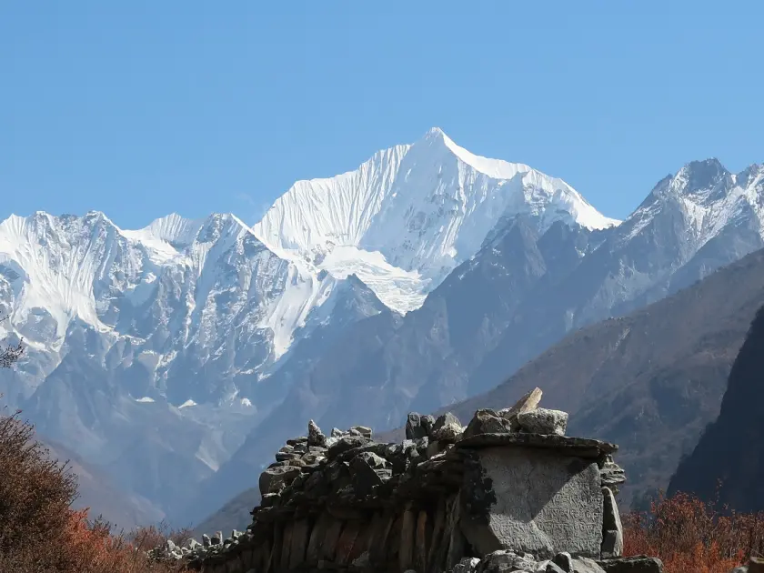
Find out how the 2015 Nepal earthquake affected the Langtang Valley (3,430m). Read about the causes of the Langtang Lirung (7,227m) avalanche and the historic event.
Event Detail
Statistical Data and Impact
Earthquake Magnitude
7.8 Mw (Gorkha Earthquake)
Total Fatalities (Langtang)
243 (175 locals, 41 foreigners, 27 staff)
Avalanche Material
40 million tons of rock, snow, and ice
Debris Thickness
Up to 20 meters deep in parts
Air Blast Speed
Estimated over 150 km/h
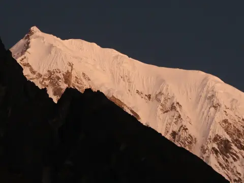
Initially, a huge earth-shaking 7.8 Magnitude quake pulverized the heart of central Nepal with its epicenter. This epic event instantly caused a disastrous ice and rock avalanche from the slopes of the Langtang Lirung (7,227m). As the huge mass gathered momentum and virulence from the Kuznets curve, it was capable of releasing the explosive energy of around half an atomic bomb. This is why the Nepal earthquake of 2015 remains the largest ever natural disaster ever to hit the Langtang region.
Then, an enormous quantity of some 40 million tons of debris completely buried the original Langtang Village (3,430m). Meanwhile, a huge air blast flattened thousands of trees and structures across the entire valley in a matter of seconds. As a result, 243 local residents and tourists lost their lives in this singularly tragic event. These facts surrounding the impact of the Langtang Lirung avalanche problematize the reasons as to why safety has gained prominence.
Secondly, the extent of the orgy of destruction shocked the international trekking fraternity to its core. Help could not be rushed into the valley due to the destruction of all access routes and constant aftershocks. The survivors took food and shelter in caves awaiting helicopter rescue from Kathmandu (1,400m). These facts regarding the historical context of the earthquake amplify the complexity of the dangers facing the old village's peculiar topography.
Thirdly, the topographical features of the high Himalayas had been ultimately compromised as the Langtang Khola river was for a time entirely choked with rocks. Thick layers of grayish glacial silt filled the highest pastures that had been in frequent flow for thousands of years. The majority of the region's historic stone structures and landmarks vanished beneath around 20m of rubble. These facts surrounding the earthquake destruction influence the planning of modern-day expeditions to this region.
Fourthly, the sheer emotional impact of this "Black Day" can still be felt by the hardiest of the survivors. Every family had lost the former loving relationships to the crushing weight of massive pieces of ice or lethal back blast reactions. Eventually, it was felt that the original site was no longer suitable for a long-term settlement. This realization led to the future safe trekking region of Nepal through a careful and considered planning process.
Finally, this history of tragedy is now reflected through a shrine to the departed within a giant mani wall at the heart of the devastated remainder of the old village. Every long-distance trekker, beforehand, must pass this sacred garlanded mani wall to pay homage to these ancestors before moving forward onto the new townsite. This historical framework influences the safety provisions utilized by every professional trekking team in modern Nepal.
From Rubbles to Resilience: The Community Led Reconstruction
Follow the journey of the Langtangpa as they rebuild Langtang Valley (3,430m) with earthquake resilient structures. Find out about the advanced safety system in place to prevent future disasters.
More trail-building safety precautions: Accelerated collapse assessment of mountain passes.
Infrastructure improvements: Enhanced earthquake-resistant designs and more durable mountain lodges.
Contingency measures: Signs and radio calls with developed evacuation protocols.
Economic benefits: New permit prices of approximately $30 USD contribute to improved nature conservation.
Secondly, the resilient Langtangpa community initiated an inspiring movement towards rehabilitation and rebirth. Aligned with international aid workers, they turned the mountains back to life by clearing away the enormous boulder fields. Community members chose to construct the new trail to the Kyanjin Gompa monastery, situated at 3,830m altitude. The remarkable resolution of the Langtang community turned tragedy into triumph.
Furthermore, they harnessed advanced earthquake resistant construction technologies. These accessible and easier-to-build safety structures were transported in heavy-duty helicopter and mule transport to the 4,120-m high sites. A new network of lodges were situated well away from the base of the 7,227-m high Langtang Lirung, providing greater stability than the original timber and bamboo models.
In addition, the government of Nepal secured official permission from the United Nations World Tourism Organization, assuring international touring safety. Highly detailed land mining surveys were carried out, to enable accurate identification of the most defensible means of travelling through the valley. New suspension bridges crossed the high-crossing Langtang Khola river, with maximum durability. Travelers can traverse the high mountain passes with safety, thanks to the new Nepal Himalayan trekking safety regimen.
Additionally, the local economy secured a bright future with the reintroduction of the remarkable tea houses. Now capable of providing increased comfort to tourists, they sustain tourism profits and the community livelihoods of resilient survivors. Words used by the local survivors, present in the reconstructed settlement, include: rubble, resilient, momentum, rebuild and classic, used with total conviction. This efficient and sustainable high mountain complex rebuilding exemplifies a modern model of mountain tourism development.
A New Beginning: The Motivation behind the Langtang Village relocation
Investigate the practical, geological and socio-culturally motivated reasons underpinning the relocation of Langtang Village (3,430m) to a safer region.
Safety Feature
Description of the New Settlement
Vertical Shift
Rebuilt 100 meters above the 2015 debris field
Avalanche Safety
Positioned away from the Langtang Lirung (7,227m) fall line
Infrastructure
Modern lodges with reinforced seismic-resistant foundations
Cultural Site
New memorial wall located at the edge of the old ruins
Elevation Change
Village now sits at approximately 3,530 meters
After the 2015 earthquake, surviving villagers harbored the gigantic challenge of selecting a suitable permanent base. They effectively decided upon the entire Langtang Village (3,430m) being repositioned across the newly where the valley floor once was. This new location lies approximately 100 meters of elevation distance above the old debris fields. Therefore, Langtang village relocation was rooted firmly in long term safety assurances to tenants.
In addition, the government-selected relocation site purposely sidestepped the direct line of the future snow slide. Experts meticulously examined the terrain below the majestic peaks of Langtang Lirung (7,227m) and Kimshung (6,781m). The new site naturally buffers couples-shaped couloirs which previously released the destructive pressure wave to the old village settlement sites. This safe place to set-up a modern day village site was joint LGDR, Government officials and international geologists 'bound together in research'.
At the same time, the construction process incorporated modern day engineering adoptions to Stone Lodge residence and founding. Reinforced house foundations utilized resilient and durable foundations while coupled with resilient flexible timber frames to resist future seismic activity in the area. These earthquake resistant households now act as welcoming and homely bases for international treks adventurers at numbers of today. The entire new village stands resilient against future earthquakes.
Furthermore, the migration and move away also architects a strong physical border to darken and deride the past devastated descendant community. Trekkers can still view the old village debris fields for which a large memorial mani wall now separates entrance from the new community. This memorial mani wall allows a pause for thought before gently entering brightly lit high altitude community.
Finally, the altitude was A step further and demanded aside from the devastation caused by the earthquake and avalanche. Trekkers are rapt; as the altitude allowed more magnificent scenic views stretching toward the clear glaciers of the surrounding mountaintops; requiring summit-of-Kyanjin Gompa (3,830m). Fresh air blows through the Tibetan sky-high community; the force of mountain storms carries no sway through the strengthened buildings. Selecting the slightly higher elevation of the new trail actually propels the linked community's high-altitude livelihoods and resilience years onward.
Trail Status 2026: damaged paths restored, & bridges reinforced in preparation for future visitation
Check the current Langtang trail status for 2026 with new stone stairs and bridges. Find out why the path to Kyanjin Gompa (3,830m) is safer today.
Stone stairs: Further stairs may have been designed into precarious vertical sections of the trail.
Bridge safety: Visually checked components, cables, and foundation supports of all new bridges.
Navigation markers: Needles, cones, and highly visible yellow and white markers (in order to facilitate trekking in foggy conditions).
Park fee: Anticipate that Kalatalang National Park fee will be approximately $30 USD per person (7-figure international funding).
At present, the trekking route traversing the Langtang Valley (3,430m) has been thoroughly and professionally restored. Trail crews succeeded in removing all the enormous boulders that had previously blocked the legendary mountain passes. They installed new clear signage, including well-marked stone stairs to make the steep sections more approachable for average travelers. Thanks to these investments, you now have a level, consistent hiking surface that will smooth your Himalayan pilgrimage.
Meanwhile, the local government has installed sturdy new suspension bridges to cross the larger rivers coming out of the mountains. Engineers decided to strengthen the cables and foundations of these crossing points to elevate their load-bearing capabilities and safeguard against installation failure. They also intend to fortify these modern suspension bridges with much more durable frames to better support summer season wave delays and high altitude weather conditions—hastening your safe passage, despite the surge in fellow travelers.
Specifically, the path between Lama Hotel (2,480m) and Ghoda Tabela (3,030m) is now broader, straighter, and less forestry overwatch. Loaders on the trail are scheduled to sweep mountain-flow debris consistently by dedicated local crews. You will now see clear signage with listing useful tentative times and distances to the next secure destination. These infrastructure improvements also include improving the directional signage for the third time, so now you do not have to worry about missing the next fork in the Khumba valley, on the way to Kyanjin Gompa.
Once you arrive at the high-altitude hamlet of Kyanjin Gompa (3,830m), you will find the final approach to be surprisingly well-developed. The paths are now well-paved around yak herders' barns and Buddhist temples called chortens and there now exist numerous stone walkways leading toward the amazing scenic viewpoints of Tserko Ri (4,984m) and Kyanjin Ri (4,773m)—viewpoints above the alpine environment that provide the ultimate perspective of the mountain range. These extra pathways are among the most accessible in Nepal.
With respect to trail status, it is a testament to a decade of 7-figure international investment. The ongoing stream of trekking permits and guide fees are dedicated funds that support the region's ecological monitoring and trail safety checks. You may trek with the assurance that the environment is being protected and every safety check is being conducted by park rangers. The time has arrived for you to take the Himalayan trek you deserve with peace of mind in this legendary green valley.
Earthquake Resilient Teahouses: Luxury in the Wilderness
Travel staying in our earthquake resilient teahouses along the new Langtang trek route(3,430m). Dine in your own private bathroom and enjoy Wi-Fi and insulation in the extreme Himalayas.
Amenity Type
Availability and Estimated Cost
Wi-Fi Access
Available up to Kyanjin Gompa (3,830m); $3–$5 fee
Hot Showers
Solar or gas powered; $3–$6 per session
Private Bathrooms
Increasingly common in newer lodges; $15–$20 per night
Room Heating
Common dining room heaters; private heaters available for fee
Charging Points
Available in dining halls or private rooms; $2–$3 per device.
At first the rebuilding of the valley was not only about safety, it was to be modern and a) comfortable for international tourists. Engineers constructed modern reinforced foundations and flaxy timber frame systems as replacements for traditional dry-stone walls to support the increasing number of new lodges from Lama Hotel (2,480m) to Kyanjin Gompa (3,830m). The result is that now every accommodation is designed according to earthquake standards and provides a reliable refuge to trekkers in the high central Himalayas
Ironically, the next step in the rebuilding process was with a) massively improved insulation systems to block out the freezing temperatures at 3,500m below the extreme, fragile cold mountain climate. New double-glazed windows and insulated walls keep the draught out, with the modern dining halls comfortably insulated from the approaching sunset over Langtang Lirung (7,227 m). These improved modern lodges for trekking provide a gratifying improvement for travelers searching for induced, alpine comfort.
In addition, numerous teahouse owners have opted to incorporate private bathrooms and hot shower facilities into their new rooms, so you need not step out into the freezing night air to access communal outdoor toilets in most settlements. Solar panel systems supply dependable power for lighting and to charge electronic device chargers. This improved trail infrastructure makes the tough trek over the valley considerably more manageable for inexperienced hikers.
In addition, modern satellite systems deliver high-speed Wi-Fi to most of the remotest parts of the Langtang Valley allowing you to share the amazing images of the peaks of Kimshung (6,781 m) with friends and family unhindered. Most of these lodges charge a modest 2 to 5 USD for connectivity, so you can stay connected and in touch in this pristine wilderness of Nepal.
Finally, the cuisine in these upgraded lodges has extended to more international fare including hand-baked bread and organic coffee for the weary trekker. Meals are freshly cooked and served by staff in hygienic and stringent procedures and food standards. Choosing the rebuilt Langtang trail means you choose a community experienced in high-altitude hospitality to ensure your needs are met.
The Single Standing House: An living monument on trail
Discover the infamous "single standing house" on the Langtang trail (3,430m), the lone survivor of the 2015 avalanche. Site of reflection for trekkers.
Location: Located on the northern fringes of the abandoned Langtang settlement (3,430m)
Significance: The lone survivor of the 2015 snow avalanche and quake cascade
Geology: Guarded from extinction by a vast talus force
Photography: A must-shoot spot to chronicle the glacier history.
Next, trekkers doing Langtang Valley Trek will emerge upon a breathtaking beacon of the past that silently witnesses to the watersheds of 2015. Nestled tightly up against a deep stone cliff face, a lone house miraculously tolerated the huge avalanche from Langtang Lirung (7,227m). The overhanging granite mountain almost had the appearance of a natural shield that directed the oncoming mass of ice and snow over the roof. This isolated house marker remains a sobering symbol of human faith amid the surrounding hunter-gatherer of archaeology.
Moreover, the solitary house remains largely unchanged as a focal point for reflection for each trekking group. See above how the monster pressure wave slightly changed the wrinkles in the front corner of the stonework. This iconic visualization gives a perspective on the expense of the calamitous event that once decimated the river valley floor. This historic Langtang dwelling breaks the distance between ante and post-cataclysm worlds.
In particular, local guides stop here during the trek to share grisly survivor stories of how others contained themselves during the disaster. The proximity to the vertical cliffs of the northern valley wall saved this character of structure from complete destruction. Listen in to the world of stillness that echoes around the weathered stone coffin of a mountain from which there is no return. This surviving mountain shrine provides a thermal insight into the typical architecture of the region circa 2015.
In addition, this memorial to the forces of nature reminds survivors of the uncrushable worlds through which they trek every day. Recognize the ash gray escape zone measuring miles from the vantage point mid-mountain at 3,400 meters. The house commemorates the resourcefulness of the Kyrgyzstani builders whose attempts at harmony with nature defied a dead divine zone. These mountain histories deepen your passage through the mountain region and furnish a detailed emotional story arc.
Finally, the legendary single house trumps any other example of living historical witness of the region. It is a movingly humbling reminder of the heartfelt lives that will mostly forever be inoperable all around us. Exit the site with one eye on safety in the new and improved village, but two toward the past lessons of life on the rocky titans.
Safety rules & regulations: Why guides really do matter
Find out why it’s now compulsory to employ a licensee guide for the 3,430m Langtang trek in 2026. Here’s how guides improve your safety, follow the trail, and contend with altitude.
Guide Service Type
Estimated Daily Cost (USD)
Included Features
Licensed Expert Guide
$30 – $40
Safety monitoring, navigation, and cultural history.
Porter-cum-Guide
$25 – $30
Basic guiding plus carrying up to 10kg of gear.
Specialist Language Guide
$45 – $60
Fluency in French, German, or Spanish for clarity.
Local Nature Guide
$30 – $35
Specialized knowledge of Langtang's flora and fauna.
In the initial efforts to protect the safety of all traveling through the mountains, by 2023, the Nepal authorities had implemented new trekking laws. These regulations are very strict, requiring that all international hikers employ a domestically certified guide on entering national parks. For this reason, all foreigners will have to trek unsupported in the Langtang Valley (3,430m) from 2026 – making the chosen guide essential with the options available for mountain altitude safety management.
However, hiring a knowledgeable guide is your best way of monitoring the bridge conditions in the Himalayas and any imminent climate change. The guide will be trained to identify the early onset of Acute Mountain Sickness (AMS). Your guide will be conscious of the terrain beneath the Langtang Lirung (7,227m) and other summit feet. This collaboration of techniques for mountain altitude safety management can reduce the dangers of any additional shoulder turmoil you seek during the Central Himalaya peaks day routes.
In addition, this guide registration process will be supporting the local economy and community-led conservation initiatives. Reliable guides will have to be approved by registered trekking agents to restrict inadequate service. They will manage all official forms such as the TIMS card and Langtang National Park (30 USD) entry fee requests. From this regulated trekking framework, resilient locals has gained sustainable employment after re-developing the entire valley.
In the same breath, having a local hiking partner can bring the cultural understanding needed and proven communication with the village heads. Your guide will highlight the 2015 "Black Day" history among the local new developments. They will supervise your daily teahouse choices throughout the Mundu (3,543m) and the river crossings of safety on the Langtang Khola. This cultural connection for trekking is actually contributing to your maximum safety.
Finally, hiring licensed guides should have the ability to intervene and deploy helicopter rescue contact blocks in the event of an accident. They will usually have standard communication devices that can reach beyond your typical mobile phone range even at high altitude. Just relax and gaze at the mountain vistas while your nominated guide manages all forms of logistics possible. For this reason, your assistance in employing a licensed Nepal guide will ensure all your minimum standards are met in both safety and comfort.
Beyond the Valley: safety at Kyanjin Ri & Tserko Ri
Kyanjin Ri (4,773m) and Tserko Ri (4,984m) are safe viewpoints in 2026 for the adventurous ascents. Interesting trail info for these panoramic viewpoints at high altitudes.
Kyanjin Ri (4,773m): light moderate 3-4 hour journey with broad, settled paths for the majority of experienced walkers.
Tserko Ri (4,984m): hard 7-9 hour journey, demanding stamina and consistent pace.
Directional Navigation Pick: Follow yellow-white marshals intermittently chalked on aggregates to stay on track.
Caution: Always view the weather forecast at Kyanjin Gompa (3,830m) before traveling.
Anyway, most pilgrims will then ascend to the spiritual center of Kyanjin Gompa (3,830m) to begin the legendary side-top journeys. The two most common angles for joining in are the two viewpoints of Kyanjin Ri (4,773m) and the summit-tough Tserko Ri (4,984m). Geomorphologists validate the fact that these elevated rock formations of higher altitudes maintained crustal stability during the 2015 Nepali earthquakes. Thus, these lofty flight decks are considered top safe to travel for ready walkers in the time frame.
Subsequently, the narrow ascends toward the Kyanjin Ri (4,773m) operate over a broad path of rock-scarred dirt. This ascend is as short as it is visual and advances over free of most avalanche channels by means of an brisk slope. Your trail travel over broad dusty expanses to the prayer-flag walls at a pace of about an hour and a half to become airborne from your hotel. Your mountaintop climb will then have unparalleled, high-elevation eye-candy with a 360 span view of the Lanzgan Thang Glacier.
Especially because of its one-day duration, the Tserko Ri (4,984m) requires unique pedal power of heart and muscle. While you steadily labor your way over a bend stream and over an ever-expanding series of rocky switchbacks, start your trek before sun-up. With hard-won stamina, your team can then enjoy a broad horizon of summits as you ascend past the clouds each afternoon during the crystal-clear season.
Further, the certified stability of these viewpoints helps to encourage acclimatization at a higher elevation before heading upward. With the potential to see all route signs along the spine of the higher summit to provide guidance while not perplexed, these solid walking places will soothe your subconscious as your lungs navigate the higher altitude. You will appreciate the top solid ground to walk across as you experience the wispy air of near 5 km in elevation.
Ultimately, the panoramic views from these summits stand as the evidence of the fantastic repair of the intervening valley below. The tower-sharp summit of the new Langtang Village (3,430m) is located on a secure ridge above the flaxen fields and pastures below. The surrounding crowns of Ganchenpo (6,387m) and Yala Peak (5,520m) mock the valley's destruction with enduring power. This high-altitude panorama is really a peak adventure to complete your path across the rebooted valley.
Seasonal Tips: landslide and Himalayan snow season
Find out which time of year is most safe for trekking Langtang Valley (3,430m) in 2026. Understand why Spring and Autumn are preferable. (154 characters)
Season
Best Months
Visibility | Safety Rating
Spring
March - May
High (Floral) | Excellent
Autumn
October - November
Excellent (Clear) | Best/Safest
Winter
December - February
High (Snowy) | Challenging/Cold
Monsoon
June - August
Low (Foggy) | High Risk/Slippery
How to choose the safest time to trek to Langtang Valley on the glaciers? Precaution for one’s own safety by selecting the correct trekking window is the most important starting step. The weather above Langtang Lirung (7,227m) is predictable from March to May and October to November. In these months weather remains stable to avoid the extremes of Himalayan high land change. It should lessen the past unpredictability of high land disparities.
Secondly, coming to the cooler months of March-May, rhododendron (rhododendron) bloom, the winter snow melts from the air above Kyanjin Gompa (3,830m) to make the temperature milder. The trekkers of early spring should bring some microspikes with them, just in case they have to trek up icy slopes shaded by the sun. The spring season, in Himalaya, is the most preferred for its moderate high temperature and full of colorful mountain flora.
Thirdly, the pre-winter months of October-November give the sharpest contrast for expert mountain photography. The dust, dust of the monsoon drops from Himalayan mountain clouds and reveals the brilliance of crystal clear Himalayan mountain views. The trails are firm and dry, and so trekking down is safe regarding any unexpected slipping from the steep slope. Autumn bringing peak season, is said to be most safe for passing the high passes and the sharp ridges.
On the other hand, be off season of the least preferring months of summer the monsson thunders have made more landslide questions. The monsoon when rains pour from the Himalayan mountain water clouds, make the foothill trails between Syaburubesi (1,550m) and Lama Hotel (2,480m) much treacherous. Leeches attack the lower forest since many dawns are cloudy in the valleys of much heavy rain. Therefore, the monsoon, become slow and uneconomical with any chances of safely avoiding the major trails bumping downward.
Lastly, the years of December to February are deeply cold and snowy, and the upper valley is usually buried under heaps of snow. Many teahouses above Langtang Village (3,430m) are closed at the freeze of the hill marsh, and so you will need warm, cold weather gear and desired skill to gain successfully. Understanding this pre-winter and post-winter season weather cycle of the safest periods makes a joyful holiday trip in "Valley of Glaciers."
The final verdict: How your steps endorse a resurrected valley
Discover why trekking in 2026 in Langtang (3,430m) not only can be done safely, but is crucial for local recovery. Your efforts directly sustain the valley's sustainability.
Local Economic Development: Contributing to trail repair and national park protection by contributing a portion of your trekking fee.
Direct Financial Source: Staying at locally owned lodging keeps your funding local.
Cultural Sustenance: Enhancing incentives for ancient monasteries and remembrance of unique Tamang crafts.
Safety and Security: Visitor support allows permanent installation of mountain rescue crew.
As a final note, the verdict on trekking in 2026 for travelers is that Langtang Valley is entirely safe. The pioneering resettlement of villages and trail improvements have set up an exceptionally strong trekking infrastructure. Your visit in the valley provides the crucial income to uphold these world-class safety levels. This sustainable mountain tourism plan assures the local Langtangpa will safeguard their ancestral homeland.
In addition, every dollar flowing through a simple meal or a comfy bed injects those funds directly into the local economy. The tourism industry is the foundation of earnings for the families living near Kyanjin Gompa (3,830m). The support from engaged visitors enables them to build with earthquake-proof technology and finance high-caliber education for their children. Your influential travel decisions expedites the sustainability of this "reborn" mountain life.
Similarly, the enforced guide policies have created a safer setting for locals and tourists alike. This measure guarantees all emergency response procedures are followed without failing back on tradition. You are not a mere visitor but rather an integral part in the ongoing revival of Himalayan communities. Backing the exclusive trekking sector is the surest way to secure their historical remembrance.
Hence, the "Valley of Glaciers" has reclaimed itself from a tragic event into a hopeful beacon. The climb to the peak of Tserko Ri (4,984m) signifies another personal and group achievement. You will pick up that the nations spirit over time is equally hearty as the mountain ridges. It surely beckons one of the most meaningful tribal connections known to man.
Most importantly, the experience of the local guesthouses surpass their former hospitality. Gelling with a survivor over a steaming bowl of butter tea introduces an unforgettable perspective on spiritual resilience. Your travel memory through the valley sounds the survivor a heartbeat further in the rise and fall of the crumbling mountain dividers. The safe trek through Langtang not just your steps but your heart in need of much healing.
Faqs:Is Langtang Valley Safe to Travel after Earthquake?
1. Is Langtang Valley safe to trek in 2026 after the 2015 earthquake? Yes, Langtang Valley is completely safe for trekking in 2026. The trails in Langtang Valley are fully restored now. They have reinforced bridges and new stone stairs. The people who live in Langtang Valley have worked hard to make the route more secure. They have safety protocols in place. This makes Langtang Valley more secure than before. It still has its beauty. 2. What happened to Langtang Village during the 2015 earthquake? The 2015 earthquake was very bad for Langtang Village. It triggered a landslide. This landslide buried much of Langtang Village. It was an event. It taught us lessons about risks in the Himalayas. Today the community has moved to a site. They have rebuilt their homes stronger. 3. How has Langtang Valley recovered since the 2015 disaster? Langtang Valley has shown resilience. The community has led the reconstruction efforts. New homes, teahouses and infrastructure are stronger now. The trails are improved. The bridges are reinforced. Locals warmly welcome visitors. They have turned tragedy into a story of hope and revival. 4. Why was Langtang Village relocated after the earthquake? The village moved to an higher location. This location is away from avalanche and landslide paths. The community made this decision. They wanted to ensure long-term safety. They also wanted to honor their heritage and ancestral roots in Langtang Valley. 5. What is the current trail status in Langtang Valley for 2026? In 2026 the damaged paths in Langtang Valley are fully restored. They have stone stairs and reinforced bridges. The route to Kyanjin Gompa is safer and well-maintained. It offers trekking experiences for visitors. Visitors can explore the Himalayan valley. 6. Is a guide mandatory for Langtang Valley Trek? Yes, hiring a guide is mandatory. It is also highly recommended for the Langtang Valley Trek. Guides ensure safety. They navigate trails effectively. They provide insights. They handle emergencies. This is especially important in this earthquake-affected region. 7. Are Kyanjin Ri and Tserko Ri safe to climb? Kyanjin Ri and Tserko Ri offer hikes. They have safety after trail improvements. Proper acclimatization, weather checks and experienced guides make these side trips secure. They highlight panoramic views of Langtang Lirung and surrounding peaks. 8. What are the best seasons to visit Langtang Valley? Spring (March-May) and autumn (September-November) are ideal for Langtang Valley. These seasons provide weather. They have views. They have landslide risks. This is compared to monsoon or deep winter snow. It ensures more enjoyable trekking. 9. What safety precautions should I take in Langtang Valley? Follow guide instructions. Stay on marked trails. Monitor weather. Acclimatize properly. Carry gear. Respect rules. Support community initiatives. These steps ensure travel in the resilient post-earthquake Himalayan landscape of Langtang Valley. 10. How does trekking in Langtang support local communities? Your visit directly aids recovery. It provides income to rebuilt teahouses and families. Tourism funds safety measures. It funds infrastructure and cultural preservation. It helps the resilient Langtangpa community thrive after the 2015 tragedy. 11. Are there landslide risks in Langtang Valley today? While landslides can occur during rains improved trails have greatly reduced risks. Reinforced structures and seasonal monitoring have also reduced risks. Experienced guides help avoid danger zones. This makes 2026 trekking much safer than post-earthquake. 12. What permits are needed for Langtang Valley Trek? You need a Langtang National Park entry permit. You also need a TIMS card. These are easily arranged through operators. Guides ensure all documentation is handled correctly. This ensures a hassle-legal trekking experience in Langtang Valley. 13. Is Langtang Valley suitable for beginner trekkers? Yes, Langtang Valley is excellent for beginners. It has difficulty. The trails are restored. Teahouse accommodation is available. Proper preparation, acclimatization and a professional guide make this a safe and rewarding first Himalayan adventure. 14. How has infrastructure improved in Langtang after 2015? Post-earthquake reconstruction brought buildings. It brought trails, reinforced bridges and reliable services. New teahouses offer facilities. This enhances safety and comfort for trekkers visiting Langtang Valley. 15. What should I pack for Langtang Valley Trek safety? Pack trekking boots. Bring weather- layers. Bring rain gear, trekking poles, headlamp, first-aid kit, water purification, sunscreen and snacks. A good sleeping bag and altitude medication ensure safety and comfort on the Langtang Valley trail. 16. Can I trek Langtang Valley solo in 2026? Solo trekking is not recommended. It is often restricted. Professional guides are mandatory for safety, navigation and compliance. Joining a group with an experienced guide provides security. It enriches the experience in Langtang Valley. 17. Are there avalanche risks in Langtang Valley? Avalanche risks exist in areas during winter and early spring. Guides monitor conditions closely. They choose routes. They advise on timing. Proper seasonal planning significantly minimizes these Himalayan hazards in Langtang Valley. 18. How difficult is the Langtang Valley Trek? The trek is moderate. It has ascents. It is suitable for beginners to intermediates. Daily walks are 5-7 hours. There is teahouse support. Acclimatization days and restored trails make it manageable and enjoyable. 19. What emergency services are available in Langtang Valley? Improved communication and local rescue coordination enhance emergency response. Guide training also enhances emergency response. Visitor support helps maintain mountain rescue capabilities. Always trek with professionals who know local protocols and resources, in Langtang Valley. 20. Why should I choose Langtang Valley for my trek? Langtang Valley offers accessible beauty. It offers immersion. It offers a chance to support communities. With 2026 trails, stunning views and heartfelt hospitality your visit contributes to Langtang Valley’s inspiring post-earthquake rebirth.