[{"name":"Everest Base Camp Helicopter Tour","duration":"1","image_url":"https:\/\/www.havenholidaysnepal.com\/storage\/trip-galleries\/1\/thumb_6cd53005d75a86e373d31419d1b14d78.webp","offer_price":1195,"url":"https:\/\/www.havenholidaysnepal.com\/trips\/everest-base-camp-helicopter-tour"},{"name":"Everest Mountain Flight","duration":"1","image_url":"https:\/\/www.havenholidaysnepal.com\/storage\/trip-galleries\/4\/thumb_3b0b4f1d6f72b0ad224daf4752f2c6e0.jpg","offer_price":285,"url":"https:\/\/www.havenholidaysnepal.com\/trips\/everest-mountain-flight"},{"name":"Everest Short Trek","duration":"9","image_url":"https:\/\/www.havenholidaysnepal.com\/storage\/trip-galleries\/5\/thumb_BXPP3621.JPEG0.02033800 1727957098.webp","offer_price":995,"url":"https:\/\/www.havenholidaysnepal.com\/trips\/everest-short-trek"},{"name":"Gokyo Valley Trek","duration":"12","image_url":"https:\/\/www.havenholidaysnepal.com\/storage\/trip-galleries\/6\/thumb_10bc469b14731f23d3ce84a7092ad53f.jpg","offer_price":1195,"url":"https:\/\/www.havenholidaysnepal.com\/trips\/gokyo-valley-trek"},{"name":"15 days Annapurna Base Camp Trek","duration":"15","image_url":"https:\/\/www.havenholidaysnepal.com\/storage\/trip-galleries\/7\/thumb_87d1533bc45faf070990aef0579e4be4.jpg0.81855100 1728285496.webp","offer_price":785,"url":"https:\/\/www.havenholidaysnepal.com\/trips\/15-days-annapurna-base-camp-trek"},{"name":"Nepal Pilgrimage Tour","duration":"14","image_url":"https:\/\/www.havenholidaysnepal.com\/storage\/trip-galleries\/8\/thumb_02c3bcf2ad2e8a4c1703e90ae747b5f1.jpg","offer_price":1475,"url":"https:\/\/www.havenholidaysnepal.com\/trips\/nepal-pilgrimage-tour"},{"name":"UNESCO World Heritage Site Tour","duration":"10","image_url":"https:\/\/www.havenholidaysnepal.com\/storage\/trip-galleries\/9\/thumb_unesco-world-heritage-site-Lumbani-temple-buddhists-hindus-kathmandu-nepal0.36988600 17347617740.93089500 1737469667.webp","offer_price":715,"url":"https:\/\/www.havenholidaysnepal.com\/trips\/unesco-world-heritage-site-tour"},{"name":"Island Peak Climbing","duration":"16","image_url":"https:\/\/www.havenholidaysnepal.com\/storage\/trip-galleries\/11\/thumb_Island peak0.53947000 1734692503.webp","offer_price":2495,"url":"https:\/\/www.havenholidaysnepal.com\/trips\/island-peak-climbing"},{"name":"Upper Mustang Trek","duration":"18","image_url":"https:\/\/www.havenholidaysnepal.com\/storage\/trip-galleries\/12\/thumb_upper mustang 7 Oct-2024.jpg0.95398900 1728286166.webp","offer_price":2995,"url":"https:\/\/www.havenholidaysnepal.com\/trips\/upper-mustang-trek"},{"name":"Annapurna Circuit Trek","duration":"16","image_url":"https:\/\/www.havenholidaysnepal.com\/storage\/trip-galleries\/15\/thumb_tibetan-flags.jpg0.04843900 1728289138.webp","offer_price":985,"url":"https:\/\/www.havenholidaysnepal.com\/trips\/annapurna-circuit-trek"},{"name":"Gosainkunda Lake Trek","duration":"10","image_url":"https:\/\/www.havenholidaysnepal.com\/storage\/trip-galleries\/16\/thumb_5A8083B3-C007-41A8-853F-D0C37C97D235_1_105_c.jpeg0.52581200 1731845258.webp","offer_price":595,"url":"https:\/\/www.havenholidaysnepal.com\/trips\/gosainkunda-lake-trek"},{"name":"Zip-lining in Pokhara and Dhulikhel","duration":"1","image_url":"https:\/\/www.havenholidaysnepal.com\/storage\/trip-galleries\/18\/thumb_215f765e2ebc995dd5c800b4bfdbacc3.jpg","offer_price":82,"url":"https:\/\/www.havenholidaysnepal.com\/trips\/zip-lining-in-pokhara-and-dhulikhel"},{"name":"Annapurna Heli Tour","duration":"1","image_url":"https:\/\/www.havenholidaysnepal.com\/storage\/trip-galleries\/19\/thumb_d71a6bbb9fd4da8d1b567a5cdbdec85d.jpg","offer_price":555,"url":"https:\/\/www.havenholidaysnepal.com\/trips\/annapurna-heli-tour"},{"name":"Paragliding in Pokhara","duration":"1","image_url":"https:\/\/www.havenholidaysnepal.com\/storage\/trip-galleries\/20\/thumb_de788d2dd9726783431f882c007efae1.jpg","offer_price":65,"url":"https:\/\/www.havenholidaysnepal.com\/trips\/paragliding-in-pokhara"},{"name":"Ultra-Flight in Pokhara","duration":"1","image_url":"https:\/\/www.havenholidaysnepal.com\/storage\/trip-galleries\/21\/thumb_e27a9fb572a5c21611bb2a3c18e4b8f0.jpeg","offer_price":175,"url":"https:\/\/www.havenholidaysnepal.com\/trips\/ultra-flight-in-pokhara"},{"name":"Sarangkot Hiking","duration":"1","image_url":"https:\/\/www.havenholidaysnepal.com\/storage\/trip-galleries\/22\/thumb_100ef822fea19987166c6c1366215f15.jpg","offer_price":55,"url":"https:\/\/www.havenholidaysnepal.com\/trips\/sarangkot-hiking"},{"name":"Mera Peak Climbing","duration":"18","image_url":"https:\/\/www.havenholidaysnepal.com\/storage\/trip-galleries\/24\/thumb_d16ae3895f678cf26ffbf2455f541fb5.jpg0.31883400 1732617790.webp","offer_price":2475,"url":"https:\/\/www.havenholidaysnepal.com\/trips\/mera-peak-climbing"},{"name":"Lower Dolpo Trek","duration":"18","image_url":"https:\/\/www.havenholidaysnepal.com\/storage\/trip-galleries\/26\/thumb_Dolpo Galary - 1.JPG0.37725200 1727939952.webp","offer_price":2995,"url":"https:\/\/www.havenholidaysnepal.com\/trips\/lower-dolpo-trek"},{"name":"Nagarkot Sunrise\/Sunset Tour","duration":"1","image_url":"https:\/\/www.havenholidaysnepal.com\/storage\/trip-galleries\/27\/thumb_5147a5532644283a380f2e86f3857c13.jpg0.17748000 1728488108.webp","offer_price":30,"url":"https:\/\/www.havenholidaysnepal.com\/trips\/nagarkot-sunrise-sunset-tour"},{"name":"16 day Everest Base Camp Trek","duration":"16","image_url":"https:\/\/www.havenholidaysnepal.com\/storage\/trip-galleries\/28\/thumb_IMG_4311.JPG0.64984800 1727942213.webp","offer_price":1475,"url":"https:\/\/www.havenholidaysnepal.com\/trips\/16-day-everest-base-camp-trek"},{"name":"Ghorepani Poon Hill trek with Jungle Safari and Trishuli River Rafting -13 days","duration":"13","image_url":"https:\/\/www.havenholidaysnepal.com\/storage\/trip-galleries\/29\/thumb_Ghorepani Poon hill.jpg0.48460800 1728281439.webp","offer_price":795,"url":"https:\/\/www.havenholidaysnepal.com\/trips\/ghorepani-poon-hill-trek-with-jungle-safari-and-trishuli-river-rafting--13-days"},{"name":"Mardi Himal Trek","duration":"12","image_url":"https:\/\/www.havenholidaysnepal.com\/storage\/trip-galleries\/30\/thumb_s1.jpg0.62112600 1728200721.webp","offer_price":795,"url":"https:\/\/www.havenholidaysnepal.com\/trips\/mardi-himal-trek"},{"name":"Langtang Valley Trekking","duration":"10","image_url":"https:\/\/www.havenholidaysnepal.com\/storage\/trip-galleries\/31\/thumb_IMG_4702.JPG0.84916500 1727958504.webp","offer_price":685,"url":"https:\/\/www.havenholidaysnepal.com\/trips\/langtang-valley-trekking"},{"name":"Real Adventure Tour in Nepal","duration":"9","image_url":"https:\/\/www.havenholidaysnepal.com\/storage\/trip-galleries\/32\/thumb_ebd1b8cc78d90abe8b9003dd9a2f25bf.jpg0.82151300 1728213516.webp","offer_price":695,"url":"https:\/\/www.havenholidaysnepal.com\/trips\/real-adventure-tour-in-nepal"},{"name":"Luxury Tour in Nepal","duration":"10","image_url":"https:\/\/www.havenholidaysnepal.com\/storage\/trip-galleries\/33\/thumb_8574e61b252b18676b042caf30d830df.jpg","offer_price":1675,"url":"https:\/\/www.havenholidaysnepal.com\/trips\/luxury-tour-in-nepal"},{"name":"Luxury Everest Panorama Trek With EBC Heli Sightseeing","duration":"8","image_url":"https:\/\/www.havenholidaysnepal.com\/storage\/trip-galleries\/34\/thumb_URZL2397.JPEG0.01209600 1728027820.webp","offer_price":2575,"url":"https:\/\/www.havenholidaysnepal.com\/trips\/luxury-everest-panorama-trek-with-ebc-heli-sightseeing"},{"name":"13 day Everest Base Camp Trek with Helicopter","duration":"13","image_url":"https:\/\/www.havenholidaysnepal.com\/storage\/trip-galleries\/35\/thumb_IMG_4292.JPG0.70131500 1728029276.webp","offer_price":2095,"url":"https:\/\/www.havenholidaysnepal.com\/trips\/13-day-everest-base-camp-trek-with-helicopter"},{"name":"Manaslu Circuit Trek","duration":"16","image_url":"https:\/\/www.havenholidaysnepal.com\/storage\/trip-galleries\/36\/thumb_Mt Manaslu 03-Oct-2024.jpg0.65804900 1727938470.webp","offer_price":955,"url":"https:\/\/www.havenholidaysnepal.com\/trips\/manaslu-circuit-trek"},{"name":"Kanchenjunga Base Camp Trek","duration":"21","image_url":"https:\/\/www.havenholidaysnepal.com\/storage\/trip-galleries\/37\/thumb_Kanchanjunga Trek -!.jpg0.54744400 1727938497.webp","offer_price":2275,"url":"https:\/\/www.havenholidaysnepal.com\/trips\/kanchenjunga-base-camp-trek"},{"name":"Ganesh Himal and Sing-La Trek","duration":"18","image_url":"https:\/\/www.havenholidaysnepal.com\/storage\/trip-galleries\/38\/thumb_Ganesh Himal slider-1.jpg0.43764500 1727937722.webp","offer_price":2975,"url":"https:\/\/www.havenholidaysnepal.com\/trips\/ganesh-himal-and-sing-la-trek"},{"name":"Island Peak Climb with Everest Base Camp Trek","duration":"21","image_url":"https:\/\/www.havenholidaysnepal.com\/storage\/trip-galleries\/39\/thumb_2be428730fe83525bc85a010564f99de.jpg","offer_price":2750,"url":"https:\/\/www.havenholidaysnepal.com\/trips\/island-peak-climb-with-everest-base-camp-trek"},{"name":"Students' Adventure Tour in Nepal","duration":"12","image_url":"https:\/\/www.havenholidaysnepal.com\/storage\/trip-galleries\/41\/thumb_a926d22fbfe08cba271c41ac289b3fd2.jpg","offer_price":995,"url":"https:\/\/www.havenholidaysnepal.com\/trips\/students-adventure-tour-in-nepal"},{"name":"7 Day Poonhill Trek","duration":"7","image_url":"https:\/\/www.havenholidaysnepal.com\/storage\/trip-galleries\/42\/thumb_6196bd69036473293a2c24cc21ed57d7.jpg0.10880600 1728205378.webp","offer_price":555,"url":"https:\/\/www.havenholidaysnepal.com\/trips\/7-day-poonhill-trek"},{"name":"7 Days Annapurna Base Camp Trek","duration":"7","image_url":"https:\/\/www.havenholidaysnepal.com\/storage\/trip-galleries\/43\/thumb_IMG_2214.JPG0.08204900 1728202033.webp","offer_price":355,"url":"https:\/\/www.havenholidaysnepal.com\/trips\/7-days-annapurna-base-camp-trek"},{"name":"3 days Poonhill Trek","duration":"3","image_url":"https:\/\/www.havenholidaysnepal.com\/storage\/trip-galleries\/44\/thumb_Poon hill.jpg0.60816600 1731412954.webp","offer_price":165,"url":"https:\/\/www.havenholidaysnepal.com\/trips\/3-days-poonhill-trek"},{"name":"Poon Hill Luxury Trek with Chitwan-12 days","duration":"12","image_url":"https:\/\/www.havenholidaysnepal.com\/storage\/trip-galleries\/45\/thumb_Poom hill.jpg0.52074500 1730180532.webp","offer_price":1175,"url":"https:\/\/www.havenholidaysnepal.com\/trips\/poon-hill-luxury-trek-with-chitwan-12-days"},{"name":"Everest Luxury Trek-7 days","duration":"7","image_url":"https:\/\/www.havenholidaysnepal.com\/storage\/trip-galleries\/46\/thumb_ACRX9330.JPEG0.93236200 1728031275.webp","offer_price":1975,"url":"https:\/\/www.havenholidaysnepal.com\/trips\/everest-luxury-trek-7-days"},{"name":"Hindu Pilgrimage Tour in Nepal-10 days","duration":"10","image_url":"https:\/\/www.havenholidaysnepal.com\/storage\/trip-galleries\/47\/thumb_a94bf96a4d31decb419f6f828a3280d2.jpg","offer_price":995,"url":"https:\/\/www.havenholidaysnepal.com\/trips\/hindu-pilgrimage-tour-in-nepal-10-days"},{"name":"Everest Base Camp Short Trek-12 days","duration":"12","image_url":"https:\/\/www.havenholidaysnepal.com\/storage\/trip-galleries\/48\/thumb_IMG_4311.JPG0.52680100 1727945154.webp","offer_price":995,"url":"https:\/\/www.havenholidaysnepal.com\/trips\/everest-base-camp-short-trek-12-days"},{"name":"Everest Base Camp Hike 12 Days","duration":"12","image_url":"https:\/\/www.havenholidaysnepal.com\/storage\/trip-galleries\/49\/thumb_IMG_4260.JPG0.51729100 1728061234.webp","offer_price":1295,"url":"https:\/\/www.havenholidaysnepal.com\/trips\/everest-base-camp-hike-12-days"},{"name":"11 Days Everest Base Camp Trek","duration":"11","image_url":"https:\/\/www.havenholidaysnepal.com\/storage\/trip-galleries\/50\/thumb_IMG_4249.JPG0.21392500 1727946959.webp","offer_price":985,"url":"https:\/\/www.havenholidaysnepal.com\/trips\/11-days-everest-base-camp-trek"},{"name":"6 Days Annapurna Base Camp Trek","duration":"6","image_url":"https:\/\/www.havenholidaysnepal.com\/storage\/trip-galleries\/51\/thumb_6 days Abc.jpg0.58185400 1728200798.webp","offer_price":285,"url":"https:\/\/www.havenholidaysnepal.com\/trips\/6-days-annapurna-base-camp-trek"},{"name":"Annapurna Base Camp Trek","duration":"8","image_url":"https:\/\/www.havenholidaysnepal.com\/storage\/trip-galleries\/52\/thumb_IMG_2214.JPG0.29415700 1729487656.webp","offer_price":585,"url":"https:\/\/www.havenholidaysnepal.com\/trips\/annapurna-base-camp-trek"},{"name":"Everest Base Camp Trek with Helicopter Fly Out 10 Days","duration":"10","image_url":"https:\/\/www.havenholidaysnepal.com\/storage\/trip-galleries\/53\/thumb_IMG_4328.JPG0.52056600 1728058444.webp","offer_price":1875,"url":"https:\/\/www.havenholidaysnepal.com\/trips\/everest-base-camp-trek-with-helicopter-fly-out-10-days"},{"name":"Everest Base Camp Trek 14 Days","duration":"14","image_url":"https:\/\/www.havenholidaysnepal.com\/storage\/trip-galleries\/54\/thumb_Everest Base Camp Trek 14 days Oct 3 2024.JPG0.43202700 1727939745.webp","offer_price":1455,"url":"https:\/\/www.havenholidaysnepal.com\/trips\/everest-base-camp-trek-14-days"},{"name":"ABC Trek with Poonhill 11 Days","duration":"11","image_url":"https:\/\/www.havenholidaysnepal.com\/storage\/trip-galleries\/55\/thumb_ABC with fishtail.JPG0.21441100 1728277965.webp","offer_price":555,"url":"https:\/\/www.havenholidaysnepal.com\/trips\/abc-trek-with-poonhill-11-days"},{"name":"Muldai Hill Trek 9 Days","duration":"9","image_url":"https:\/\/www.havenholidaysnepal.com\/storage\/trip-galleries\/56\/thumb_7efee59f0a8c6817c8255bd2b9f3539d.jpeg0.19479300 1728213091.webp","offer_price":675,"url":"https:\/\/www.havenholidaysnepal.com\/trips\/muldai-hill-trek-9-days"},{"name":"Mardi Himal Trek 6 days","duration":"6","image_url":"https:\/\/www.havenholidaysnepal.com\/storage\/trip-galleries\/57\/thumb_slider 1.jpeg0.36909700 1728184981.webp","offer_price":590,"url":"https:\/\/www.havenholidaysnepal.com\/trips\/mardi-himal-trek-6-days"},{"name":"Mardi Himal Trek 7 days","duration":"7","image_url":"https:\/\/www.havenholidaysnepal.com\/storage\/trip-galleries\/58\/thumb_slider1.jpg0.61666600 1728206414.webp","offer_price":620,"url":"https:\/\/www.havenholidaysnepal.com\/trips\/mardi-himal-trek-7-days"},{"name":"Mardi Himal Trek 8 Days","duration":"8","image_url":"https:\/\/www.havenholidaysnepal.com\/storage\/trip-galleries\/59\/thumb_sli1.jpg0.38569100 1728206631.webp","offer_price":695,"url":"https:\/\/www.havenholidaysnepal.com\/trips\/mardi-himal-trek-8-days"},{"name":"14 Days Manaslu Trek","duration":"14","image_url":"https:\/\/www.havenholidaysnepal.com\/storage\/trip-galleries\/60\/thumb_sunrise-mt-manaslu-during-manaslu-circuit-larke-pass-trekking-himalaya-nepal (1)0.81855800 1738673284.webp","offer_price":885,"url":"https:\/\/www.havenholidaysnepal.com\/trips\/14-days-manaslu-trek"},{"name":"Dhampus-Sarangkot Trek with Chitwan 8 days","duration":"8","image_url":"https:\/\/www.havenholidaysnepal.com\/storage\/trip-galleries\/61\/thumb_Sarangkot Bhangyang.jpg0.75461400 1728210333.webp","offer_price":790,"url":"https:\/\/www.havenholidaysnepal.com\/trips\/dhampus-sarangkot-trek-with-chitwan-8-days"},{"name":"7 Days Golden Triangle Tour","duration":"7","image_url":"https:\/\/www.havenholidaysnepal.com\/storage\/trip-galleries\/62\/thumb_311ce1d117ee0ba75402a7c301bcdf830.73532400 1739179809.webp","offer_price":845,"url":"https:\/\/www.havenholidaysnepal.com\/trips\/7-days-golden-triangle-tour"},{"name":"Annapurna Circuit Trek 12 days","duration":"12","image_url":"https:\/\/www.havenholidaysnepal.com\/storage\/trip-galleries\/63\/thumb_IMG_20161024_092237.jpg0.57796600 1728289938.webp","offer_price":695,"url":"https:\/\/www.havenholidaysnepal.com\/trips\/annapurna-circuit-trek-12-days"},{"name":"Everest Base Camp Budget Trek 16 Days","duration":"16","image_url":"https:\/\/www.havenholidaysnepal.com\/storage\/trip-galleries\/64\/thumb_IMG_4423.JPG0.92579200 1728144669.webp","offer_price":958,"url":"https:\/\/www.havenholidaysnepal.com\/trips\/everest-base-camp-budget-trek-16-days"},{"name":"Poonhill Budget Trek 7 Days","duration":"7","image_url":"https:\/\/www.havenholidaysnepal.com\/storage\/trip-galleries\/65\/thumb_5be067852d0c5228d6f3155bc425c6b5.jpg","offer_price":395,"url":"https:\/\/www.havenholidaysnepal.com\/trips\/poonhill-budget-trek-7-days"},{"name":"Annapurna Base Camp Budget Trek 8 Days","duration":"8","image_url":"https:\/\/www.havenholidaysnepal.com\/storage\/trip-galleries\/66\/thumb_Pokhara.jpg0.16188000 1728212001.webp","offer_price":375,"url":"https:\/\/www.havenholidaysnepal.com\/trips\/annapurna-base-camp-budget-trek-8-days"},{"name":"The Real UNESCO Seven World Heritage Tour in Kathmandu 4 days","duration":"4","image_url":"https:\/\/www.havenholidaysnepal.com\/storage\/trip-galleries\/67\/thumb_Baudha Stupa.JPG0.63906900 1728201021.webp","offer_price":380,"url":"https:\/\/www.havenholidaysnepal.com\/trips\/the-real-unesco-seven-world-heritage-tour-in-kathmandu-4-days"},{"name":"Everest Base Camp Jeep Ride with Helicopter Return","duration":"14","image_url":"https:\/\/www.havenholidaysnepal.com\/storage\/trip-galleries\/68\/thumb_788ee5b63a6efb6f3c3d048b4270daca.JPG","offer_price":1895,"url":"https:\/\/www.havenholidaysnepal.com\/trips\/everest-base-camp-jeep-ride-with-helicopter-return"},{"name":"Annapurna Base Camp Jeep Ride with Helicopter Return 7 days","duration":"7","image_url":"https:\/\/www.havenholidaysnepal.com\/storage\/trip-galleries\/69\/thumb_abc jeep.jpg0.10280600 1728204064.webp","offer_price":1455,"url":"https:\/\/www.havenholidaysnepal.com\/trips\/annapurna-base-camp-jeep-ride-with-helicopter-return-7-days"},{"name":"Everest Base Camp Trek","duration":"15","image_url":"https:\/\/www.havenholidaysnepal.com\/storage\/trip-galleries\/70\/thumb_Everest Base Camp Trek 3 oct- 2024.JPG0.58445300 1727941472.webp","offer_price":1575,"url":"https:\/\/www.havenholidaysnepal.com\/trips\/everest-base-camp-trek"},{"name":"7 UNESCO World Heritage Tour Kathmandu 2 days","duration":"2","image_url":"https:\/\/www.havenholidaysnepal.com\/storage\/trip-galleries\/72\/thumb_Bhaktipur 3.jpg0.05559600 1728201496.webp","offer_price":150,"url":"https:\/\/www.havenholidaysnepal.com\/trips\/7-unesco-world-heritage-tour-kathmandu-2-days"},{"name":"Day Tour to UNESCO Heritage Sites","duration":"1","image_url":"https:\/\/www.havenholidaysnepal.com\/storage\/trip-galleries\/73\/thumb_228A1018.jpg0.79892500 1728199793.webp","offer_price":55,"url":"https:\/\/www.havenholidaysnepal.com\/trips\/day-tour-to-unesco-heritage-sites"},{"name":"Golden Triangle Tour in Nepal","duration":"8","image_url":"https:\/\/www.havenholidaysnepal.com\/storage\/trip-galleries\/74\/thumb_f54139cf9100f00015ffe0400687e946.webp","offer_price":588,"url":"https:\/\/www.havenholidaysnepal.com\/trips\/golden-triangle-tour-in-nepal"},{"name":"Everest Base Camp Honeymoon Tour by Helicopter with Pokhara","duration":"7 days","image_url":"https:\/\/www.havenholidaysnepal.com\/storage\/trip-galleries\/76\/thumb_RJTL7517.JPEG0.40261600 1731499989.webp","offer_price":9999,"url":"https:\/\/www.havenholidaysnepal.com\/trips\/everest-base-camp-honeymoon-tour-by-helicopter-with-pokhara"},{"name":"Yoga and Meditation Retreat Tour in Nepal","duration":"10 days","image_url":"https:\/\/www.havenholidaysnepal.com\/storage\/trip-galleries\/77\/thumb_decf8e33-6617-4400-9df0-63bf75509adf.JPG0.51948300 1731574810.webp","offer_price":2575,"url":"https:\/\/www.havenholidaysnepal.com\/trips\/yoga-and-meditation-retreat-tour-in-nepal"},{"name":"Chisapani-Nagarkot Trek","duration":"3","image_url":"https:\/\/www.havenholidaysnepal.com\/storage\/trip-galleries\/78\/thumb_0b64dfceaeab48ac36d685476bdebafb.webp","offer_price":165,"url":"https:\/\/www.havenholidaysnepal.com\/trips\/chisapani-nagarkot-trek"},{"name":"Chitwan Jungle Safari Tour","duration":"2","image_url":"https:\/\/www.havenholidaysnepal.com\/storage\/trip-galleries\/79\/thumb_IMG_1696.JPG0.28467800 1733054554.webp","offer_price":175,"url":"https:\/\/www.havenholidaysnepal.com\/trips\/chitwan-jungle-safari-tour"},{"name":"Kailash Overland Tour","duration":"16","image_url":"https:\/\/www.havenholidaysnepal.com\/storage\/trip-galleries\/80\/thumb_PA2605230.68496700 1735818657.webp","offer_price":2495,"url":"https:\/\/www.havenholidaysnepal.com\/trips\/kailash-overland-tour"},{"name":"4 nights 5 days Bhutan Tour","duration":"5","image_url":"https:\/\/www.havenholidaysnepal.com\/storage\/trip-galleries\/81\/thumb_PB0508470.23069500 1735828937.webp","offer_price":1265,"url":"https:\/\/www.havenholidaysnepal.com\/trips\/4-nights-5-days-bhutan-tour"},{"name":"Everest Base Camp Trek Without Flying","duration":"16","image_url":"https:\/\/www.havenholidaysnepal.com\/storage\/trip-galleries\/82\/thumb_308b054484eddc042e092e1ae2ae5586.webp","offer_price":685,"url":"https:\/\/www.havenholidaysnepal.com\/trips\/everest-base-camp-trek-without-flying"},{"name":"Everest Base Camp Trek by Land","duration":"16","image_url":"https:\/\/www.havenholidaysnepal.com\/storage\/trip-galleries\/83\/thumb_8f0f2784a3ae7343d193b64fe8d47c96.webp","offer_price":675,"url":"https:\/\/www.havenholidaysnepal.com\/trips\/everest-base-camp-trek-by-land"},{"name":"Everest Base Camp Trek by Jeep","duration":"16","image_url":"https:\/\/www.havenholidaysnepal.com\/storage\/trip-galleries\/84\/thumb_f82b3acdfc933bc3e0197624c001b0a6.webp","offer_price":675,"url":"https:\/\/www.havenholidaysnepal.com\/trips\/everest-base-camp-trek-by-jeep"},{"name":"Everest Base Camp Trek without Lukla Flight","duration":"16","image_url":"https:\/\/www.havenholidaysnepal.com\/storage\/trip-galleries\/85\/thumb_2d0acc76dc958e3122a3745074989914.webp","offer_price":675,"url":"https:\/\/www.havenholidaysnepal.com\/trips\/everest-base-camp-trek-without-lukla-flight"},{"name":"Langtang Valley Trek","duration":"7","image_url":"https:\/\/www.havenholidaysnepal.com\/storage\/trip-galleries\/86\/thumb_a845db06c5feada1478e8aed659fce97.webp","offer_price":199,"url":"https:\/\/www.havenholidaysnepal.com\/trips\/langtang-valley-trek"},{"name":"Everest Base Camp Trek with Gokyo Lake","duration":"17","image_url":"https:\/\/www.havenholidaysnepal.com\/storage\/trip-galleries\/87\/thumb_c6aa32f7654f2eda78134bc84ac70b79.webp","offer_price":1885,"url":"https:\/\/www.havenholidaysnepal.com\/trips\/everest-base-camp-trek-with-gokyo-lake"},{"name":"Everest Three Passes Trek","duration":"19","image_url":"https:\/\/www.havenholidaysnepal.com\/storage\/trip-galleries\/88\/thumb_db5364eaab56f5755da55868f8ca4258.webp","offer_price":1735,"url":"https:\/\/www.havenholidaysnepal.com\/trips\/everest-three-passes-trek"},{"name":"Annapurna Base Camp Trek From Pokhara","duration":"5","image_url":"https:\/\/www.havenholidaysnepal.com\/storage\/trip-galleries\/89\/thumb_49c813cf1054ff06108963924a78ee88.webp","offer_price":255,"url":"https:\/\/www.havenholidaysnepal.com\/trips\/annapurna-base-camp-trek-from-pokhara"},{"name":"Sarangkot Sunrise Tour from Pokhara","duration":"1","image_url":"https:\/\/www.havenholidaysnepal.com\/storage\/trip-galleries\/90\/thumb_932d995b8fb702634a23e8f9a0432c6e.webp","offer_price":35,"url":"https:\/\/www.havenholidaysnepal.com\/trips\/sarangkot-sunrise-tour-from-pokhara"},{"name":"Langtang Valley Trek-8 days","duration":"8","image_url":"https:\/\/www.havenholidaysnepal.com\/storage\/trip-galleries\/91\/thumb_81d3d0a6979c9ed01f65d5ade53820b2.webp","offer_price":250,"url":"https:\/\/www.havenholidaysnepal.com\/trips\/langtang-valley-trek-8-days"},{"name":"Manaslu Circuit Trek 12 days","duration":"12","image_url":"https:\/\/www.havenholidaysnepal.com\/storage\/trip-galleries\/92\/thumb_d8251bbef0c8a246a02bda5c150a27c2.webp","offer_price":675,"url":"https:\/\/www.havenholidaysnepal.com\/trips\/manaslu-circuit-trek-12-days"},{"name":"2 Days Poon Hill Trek","duration":"2","image_url":"https:\/\/www.havenholidaysnepal.com\/storage\/trip-galleries\/93\/thumb_9d8fa8f60767538857d6c7cb3a7fee8b.webp","offer_price":150,"url":"https:\/\/www.havenholidaysnepal.com\/trips\/2-days-poon-hill-trek"},{"name":"Upper Mustang Jeep Tour","duration":"6","image_url":"https:\/\/www.havenholidaysnepal.com\/storage\/trip-galleries\/94\/thumb_9a3098a6c860b87ad3339773ef5435b9.webp","offer_price":1095,"url":"https:\/\/www.havenholidaysnepal.com\/trips\/upper-mustang-jeep-tour"},{"name":"Tsum Valley Trek","duration":"11","image_url":"https:\/\/www.havenholidaysnepal.com\/storage\/trip-galleries\/95\/thumb_704a6a1eb293553827633dbd8ad7d22c.webp","offer_price":775,"url":"https:\/\/www.havenholidaysnepal.com\/trips\/tsum-valley-trek"},{"name":"Mardi Himal Trek from Pokhara","duration":"4","image_url":"https:\/\/www.havenholidaysnepal.com\/storage\/trip-galleries\/96\/thumb_c92e9ee49c2564a11c7a9ba593439efc.webp","offer_price":295,"url":"https:\/\/www.havenholidaysnepal.com\/trips\/mardi-himal-trek-from-pokhara"},{"name":"4 Days Poon Hill Trek","duration":"4","image_url":"https:\/\/www.havenholidaysnepal.com\/storage\/trip-galleries\/97\/thumb_c349e182edd0858f3e3409d945f0d2ec.webp","offer_price":215,"url":"https:\/\/www.havenholidaysnepal.com\/trips\/4-days-poon-hill-trek"},{"name":"Poon Hill Sunrise Jeep Tour from Pokhara","duration":"2","image_url":"https:\/\/www.havenholidaysnepal.com\/storage\/trip-galleries\/98\/thumb_509875052b16f6f9156db386e3592eb8.webp","offer_price":260,"url":"https:\/\/www.havenholidaysnepal.com\/trips\/poon-hill-sunrise-jeep-tour-from-pokhara"},{"name":"Muktinath Jeep Tour from Pokhara","duration":"3","image_url":"https:\/\/www.havenholidaysnepal.com\/storage\/trip-galleries\/99\/thumb_1651790cb7422703fe86d472a35d4f90.webp","offer_price":255,"url":"https:\/\/www.havenholidaysnepal.com\/trips\/muktinath-jeep-tour-from-pokhara"},{"name":"Ghorepani Poon Hill Trek from Pokhara","duration":"5","image_url":"https:\/\/www.havenholidaysnepal.com\/storage\/trip-galleries\/100\/thumb_27fa62452af4ea8e08544aaa035cc446.webp","offer_price":295,"url":"https:\/\/www.havenholidaysnepal.com\/trips\/ghorepani-poon-hill-trek-from-pokhara"},{"name":"Ghandruk, Poon Hill, Muktinath and Upper Mustang Tour","duration":"7 days","image_url":"https:\/\/www.havenholidaysnepal.com\/storage\/trip-galleries\/101\/thumb_a7dd15032cd9693005233b1df7dc63d3.webp","offer_price":685,"url":"https:\/\/www.havenholidaysnepal.com\/trips\/ghandruk-poon-hill-muktinath-and-upper-mustang-tour"},{"name":"Nar Phu Valley Trek with Annapurna Circuit","duration":"16 days","image_url":"https:\/\/www.havenholidaysnepal.com\/storage\/trip-galleries\/102\/thumb_21f5af1d6f698a6898b64413bcc19c69.webp","offer_price":1395,"url":"https:\/\/www.havenholidaysnepal.com\/trips\/nar-phu-valley-trek-with-annapurna-circuit"},{"name":"Poon Hill-Jhino Danda Hot Spring Trek","duration":"4","image_url":"https:\/\/www.havenholidaysnepal.com\/storage\/trip-galleries\/103\/thumb_b1a8563edaf102468aab613332282c6c.webp","offer_price":215,"url":"https:\/\/www.havenholidaysnepal.com\/trips\/poon-hill-jhino-danda-hot-spring-trek"},{"name":"Annapurna Base Camp Trek with Helicopter Return","duration":"4","image_url":"https:\/\/www.havenholidaysnepal.com\/storage\/trip-galleries\/104\/thumb_928d650987e2db5f449127b41966da53.webp","offer_price":895,"url":"https:\/\/www.havenholidaysnepal.com\/trips\/annapurna-base-camp-trek-with-helicopter-return"}]
Major Mountains Views on the Annapurna Base Camp Trek
Major Mountains Views on the Annapurna Base Camp Trek
Introduction: Embarking on the Annapurna Base Camp Trek for Unrivaled Himalayan Vistas
Here, let’s be honest—if you’re heading out on the Annapurna Base Camp Trek, you’re chasing those unbeatable Himalayan views. This isn’t just another walk in the woods. Out here, mountains just explode out of the ground, shooting up over green valleys and thick forests. Every day, the scenery shifts. One moment, you’re winding through rhododendron forests with rivers rushing at your side. The next, you’re climbing higher, catching your breath as snow-capped peaks loom overhead.
Likewise, you’ll pass through villages where locals greet you with a smile and a cup of tea. Wildlife and plants on the trail pops up when you least expect it. And those sunrise moments—when the mountains turn gold and clouds swirl around the summits? Those stick with you. Step by step, the trail pulls you deeper into the Annapurna Sanctuary, right to its heart. The panoramas here are unreal. Sure, the elevation gain tests your legs and lungs, but the reward? Absolutely worth it.
Mainly, you start Annapurna Base Camp Trek in Pokhara, down at 827 meters, and push all the way to Annapurna Base Camp at 4,130 meters. Along the way, you’re treated to views of Annapurna I(8,091 meters) and a whole lineup of giants. The trek ties all these wild landscapes together—you never get bored. Yeah, it’s tough. But that’s part of the deal. Stay prepared, look after yourself at altitude, and you’ll come away with stories—and memories—that last. This trek packs the Himalayas’ best into one unforgettable journey.
Major Mountains Views on the Annapurna Base Camp Trek:
Annapurna I (8091m): The highest peak, seen from ABC and earlier points like Deurali (3230m).
Annapurna South (7219m): Prominent from Ghandruk (1940m) and Poon Hill (3210m).
Machhapuchhre (6993m): Fishtail shape dominates from MBC (3700m) and trail sections.
Hiunchuli (6441m): Visible along the Modi Khola valley from Sinuwa (2340m).
Gangapurna (7455m): Appears in the sanctuary from ABC (4130m).
Annapurna III (7555m): Seen from Tadapani (2630m) and higher elevations.
Viewpoint
Elevation
Mountains Visible | Description
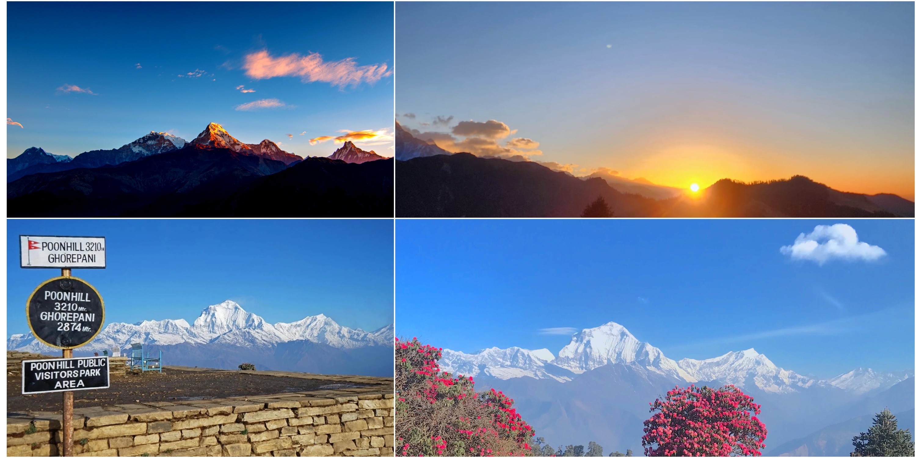
Poon Hill
3210m
Annapurna South (7219m), Dhaulagiri (8167m) | Sunrise spot with panoramic ranges.
Chhomrong
2170m
Annapurna South (7219m), Hiunchuli (6441m) | Village views over terraced fields.
Deurali
3230m
Machhapuchhre (6993m), Gangapurna (7455m) | Gateway to sanctuary with glacial sights.
MBC
3700m
Machhapuchhre (6993m) close-up | Base for Fishtail peak admiration.
ABC
4130m
Annapurna I (8091m), full sanctuary | 360-degree Himalayan amphitheater.
Key Viewpoints Along the Trail with Elevations:
Additional Facts on Trek Elevations and Views:
Total elevation gain: From Nayapul (1070m) to ABC (4130m), about 3060m net rise.
Best viewing seasons: Autumn and spring for clear skies.
Acclimatization stops: Ghorepani (2860m) helps adjust to heights.
Diverse sights: Rhododendrons bloom below 3000m, glaciers above.
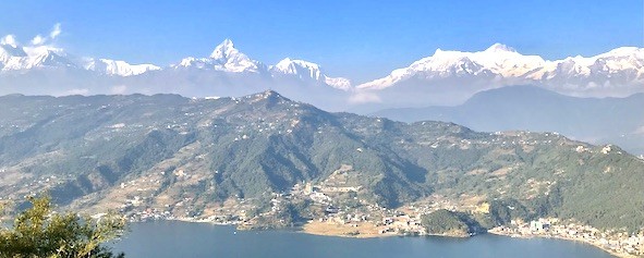
The Gateway Views: First Glimpses of the Annapurna Range from Pokhara to Nayapul
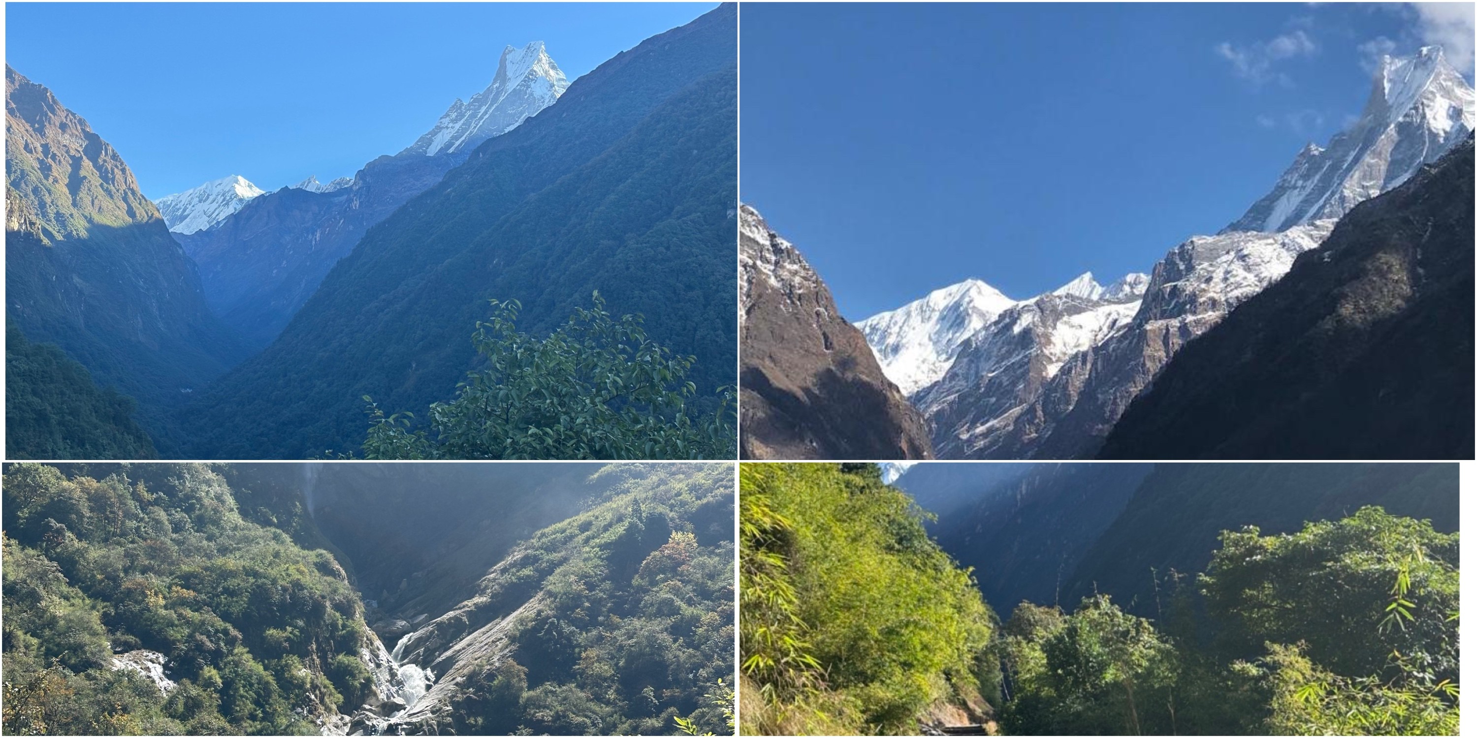
Here, everything about ABC Trek starts in Pokhara, sitting at 827 meters, right by the calm Phewa Lake. The city itself feels relaxed, but if you wake up early, the mountains tease you—just the tops peeking through the morning haze. You head out, winding your way toward Nayapul at 1,070 meters. The road twists through lush, rolling hills. Every now and then, you catch a flash of a snowy summit. It’s hard not to feel your excitement build. Villages pop up along the way, kids waving, rivers charging along far below. The city fades fast, and suddenly you’re surrounded by fields and forest. There’s this sense that everything is connected—hills, water, people, all part of the bigger picture. This is your gateway. It sets the mood for what’s coming.
Actually, the drive from Pokhara to Nayapul takes about an hour or two, but you barely notice the time. Annapurna South shows up first, tall and solid at 7,219 meters. Machhapuchhre, with its sharp, iconic shape, follows close behind. Somewhere along the way, Hiunchuli appears, standing at 6,441 meters. When you finally reach Nayapul, the real trek begins. You cross bridges over the Modi Khola, step onto rocky paths, and suddenly the valley opens up beneath you. Birds call from the trees. Sunlight filters down in patches. You feel awake, alert—ready. These first sights make you want to keep moving. The Annapurna Range waits, and somehow, it feels like it’s welcoming you in.
Sunrise Views: Panoramic Peaks from Poon Hill Overlooking Dhaulagiri and Annapurna
Up there at Poon Hill, 3210 meters high if you are going ABC via Poon Hill, trekkers wait as the sky begins to change. Golden light spills over the mountains, one peak after another catching the glow. Snow-covered summits stand still while the world below stirs awake. Before dawn breaks fully, hikers are already settled in place, quiet and watching. Then slowly, near the edge of sight, colors bloom - first soft pink, then bold orange stretching sideways. Energy fills every step of the path. Beauty of the sunrise ties into far-off peaks through soft links. Poon Hill stands out along the way because of that. People stand close, yet silence holds most of the space. Memories stay sharp long after it ends.
From Poon Hill, sitting high at 3210 meters, a sweep of Himalayan peaks spreads out below. Not far off, Annapurna South rises sharp at 7219 meters. To the west, Dhaulagiri claims the sky at 8167 meters tall. Over toward the east, Annapurna I lifts its massive form to 8091 meters. A shape rises - Machhapuchhre at 6993 meters shows its edge. Not far behind, Nilgiri stands tall among seven thousanders. When skies clear, more than thirty summits come into sight. Along the trail, rhododendrons line the way like walls of color. As dawn spreads, bird voices fill the air. A red glow climbs the horizon, catching the lens just right. Worth every cold step taken before dawn.
Cultural note: Gurung villages nearby add local charm.
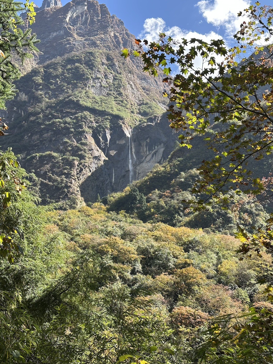
Forested Views: Emerging Views of Machhapuchare from Tadapani's Ridgelines
Further, you reach Tadapani (2630m) by weaving through thick forests, and suddenly the trees give way—there it is, Machhapuchhre (6993m), soaring right in front of you. The trail twists through rhododendrons and old oaks, sunlight slipping through the leaves and washing the peaks in gold. Hikers always stop here; it’s impossible not to. One moment you’re surrounded by green silence, the next, the mountains burst into view. Tadapani has a calm, almost meditative energy, but these mountain vistas? They strike you with real force. When sunset hits, the peaks glow warm and deep, and somehow your tired legs feel lighter.
Moreover, from this ridge, Machhapuchhre stands bold and close, almost within reach. Annapurna South (7219m) looms massive, while Annapurna III (7555m) floats behind, a little more elusive. The forest frames all of it—gnarled trunks and mossy undergrowth in the foreground, jagged snow far above. On clear days, you catch every sharp ridge and icy shadow. It’s a solid reward after the long descent from Poon Hill (3210m). Birds chatter, monkeys rustle in the branches, and the whole place feels alive, but not crowded. There’s a perfect tension: the quiet strength of nature, the rush of seeing mountains up close. Tadapani pulls you in with that intimacy, and honestly, it’s hard to leave.
Key Mountains Emerging from Tadapani Ridgelines:
Machhapuchhre (6993m): Fishtail peak emerges prominently from ridges.
Annapurna South (7219m): Pyramid shape visible at sunset/sunrise.
Annapurna III (7555m): Joins the skyline in clear weather.
Accommodation: Teahouses offer ridge views from rooms.
Best Season: Spring for blooms; autumn for clarity.
Elevation Note: Slight drop from Poon Hill aids recovery.
Riverside Revelations: Annapurna South and Hiunchuli Rising Above the Modi Khola Valley
Here, walking along the Modi Khola Valley really wakes you up. The river thunders through tight gorges, and before you know it, Annapurna South towers overhead at 7,219 meters, with Hiunchuli standing guard at 6,441. The trail sticks right beside the water, sometimes cutting so close you can feel the spray from waterfalls dropping nearby. Suspension bridges pop up often—it almost feels like you’re skipping over the river’s energy. The whole scene just keeps building as you go. Sunlight glints off the glacial water, and those mountains seem to move with you, always close.
From Chhomrong, at 2,170 meters, the Modi Khola leads trekkers straight toward the heart of the sanctuary. Annapurna South grabs your attention to the south, while Hiunchuli holds the east. The river doesn’t let up, either—it echoes through the narrowest spots, bouncing off stone and forest. You leave terraced fields behind, trading them for thick woods along the banks. With every uphill step, the peaks loom larger, and the whole journey turns into a mix of sound and sight—rushing water, birds overhead, bright flashes of rock and snow. By the end of the valley, the anticipation for what’s next is almost electric.
Major Peaks Revealed Along Modi Khola Valley:
Annapurna South (7219m): Towering southern face visible from Chhomrong to Bamboo.
Hiunchuli (6441m): Eastern guardian peaking through valley walls.
Machhapuchhre (6993m): Fishtail glimpses in upper sections.
Annapurna I (8091m): Distant teases toward sanctuary entrance.
Location
Elevation
Peaks Visible | Description
Chhomrong
2170m
Annapurna South (7219m), Hiunchuli (6441m) | Village overlook above Modi Khola.
Sinuwa
2340m
Annapurna South (7219m), Hiunchuli (6441m) | Entry to denser valley views.
Bamboo
2310m
Hiunchuli (6441m), Annapurna South (7219m) | Riverside teahouses with river sounds.
Dovan
2600m
Closer Hiunchuli (6441m), Machhapuchhre (6993m) | Upper valley narrowing.
Key Riverside Viewpoints with Elevations:
Facts on Modi Khola Valley Section:
River role: Drains Annapurna Sanctuary glaciers.
Trail length: Chhomrong to Bamboo ~10km, 5-6 hours.
Terrain: Steep steps, bridges, humid forests.
Best views: Clear mornings post-Chhomrong descent.
Wildlife: Monkeys, birds along riverbanks.
Bamboo Trail Highlights: Subtle Glimpses of Gangapurna Through Dense Rhododendron Canopies
Here, step onto the bamboo trail and you’ll find yourself slipping into a world of shadow and green. Rhododendron branches knit together overhead, building a leafy tunnel that twists upward under your boots. Every so often, Gangapurna (7455m) slips into view—just a flash of snow and sky through the trees. Sunlight breaks in now and then, dropping little pools of gold onto the mossy ground. The air feels cool and damp, almost fresh enough to taste.
In fact, it’s quiet here along the trail, except for the birds. You hear them, but they stay hidden. The peace is real, but there’s this gentle buzz of anticipation every time the forest parts and you catch another glimpse of distant peaks. The bamboo gives way, opens for a second, and you remember why you’re climbing.
From Bamboo (2310m) up to Dovan (2600m) and higher, the forest rules all over the trail. Bamboo and rhododendron everywhere, with only the occasional clearing to break things up. Gangapurna appears again—just a tease—framed by soft, filtered light. The trail narrows, sometimes turning into a set of rough steps, and every now and then, you spot a patch of flowers fighting for space. In spring, they’re everywhere, adding bursts of color to the green. The higher you go, the more the forest thins, until suddenly you step out into the open and the whole mountain world is laid out ahead.
Duration: Bamboo to Deurali ~5-6 hours, gradual ascent.
Flora: Rhododendrons peak bloom in April-May.
Terrain: Level then steep; slippery when wet.
Wildlife: Langur monkeys common in bamboo.
Transition: Leads to open views at Deurali (3230m).
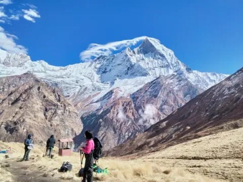
Deurali's Dramatic Overlook: Close-Up Encounters with the Annapurna Massif's Western Faces
Actually, Deurali sits at 3,230 meters, and honestly, it just hits different. When trekkers roll in, the valley suddenly opens up, and the whole western face of the Annapurna massif feels like it’s right there in your lap. The peaks tower over you—Annapurna South, bold and broad; Machhapuchhre, dramatic and sharp; Hiunchuli off to the east, balancing the skyline. Glaciers catch the sunlight and throw it back at you. The alpine meadows blend right into sheer rock walls, so you’re stuck between green softness and raw stone.
Likewise, there’s a charge in the air here at Deurali while ascending from Bamboo and Himalaya. The wind feels colder, fresher, like you’ve crossed some invisible border. This isn’t just another stop—it’s the moment the mountains get personal. Every step through Deurali’s open trails, you’re surrounded by giants, and the scale of it all finally sinks in. By the time you leave, you’re not just walking to the sanctuary—you’re ready for it.
Major Peaks in Close-Up from Deurali Overlook:
Annapurna South (7219m): Western face visible in dramatic detail.
Annapurna I (8091m): Distant western hints emerge.
Location
Elevation
Key Views | Description
Deurali
3230m
Annapurna South (7219m) western face, Machhapuchhre (6993m) | Alpine meadow overlook, valley gateway.
Nearby trails
3200-3300m
Hiunchuli (6441m), Gangapurna (7455m) | Open sightlines to massif walls.
Toward MBC
Ascent from 3230m
Closer Annapurna massif profiles | Transition to dramatic faces.
Deurali Viewpoint Details with Elevations:
Facts Supporting Deurali's Dramatic Overlook:
Ascent: From Dovan/Bamboo (~2600m) to Deurali (3230m), ~3-4 hours uphill.
Terrain: Rocky paths, waterfalls, alpine shift.
Acclimatization: Important stop before 3700m+ levels.
Best time: Clear mornings for sharp western face details.
Surroundings: Modi Khola valley narrows here.
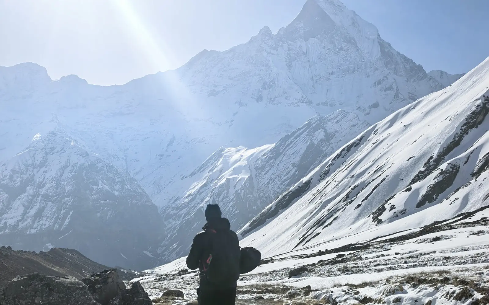
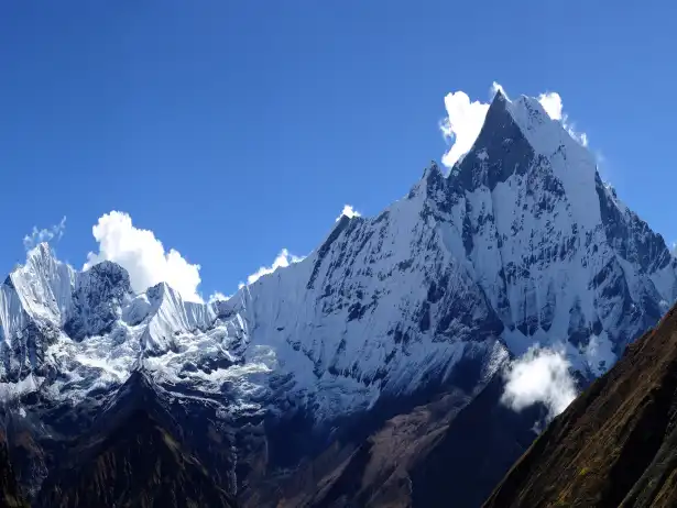
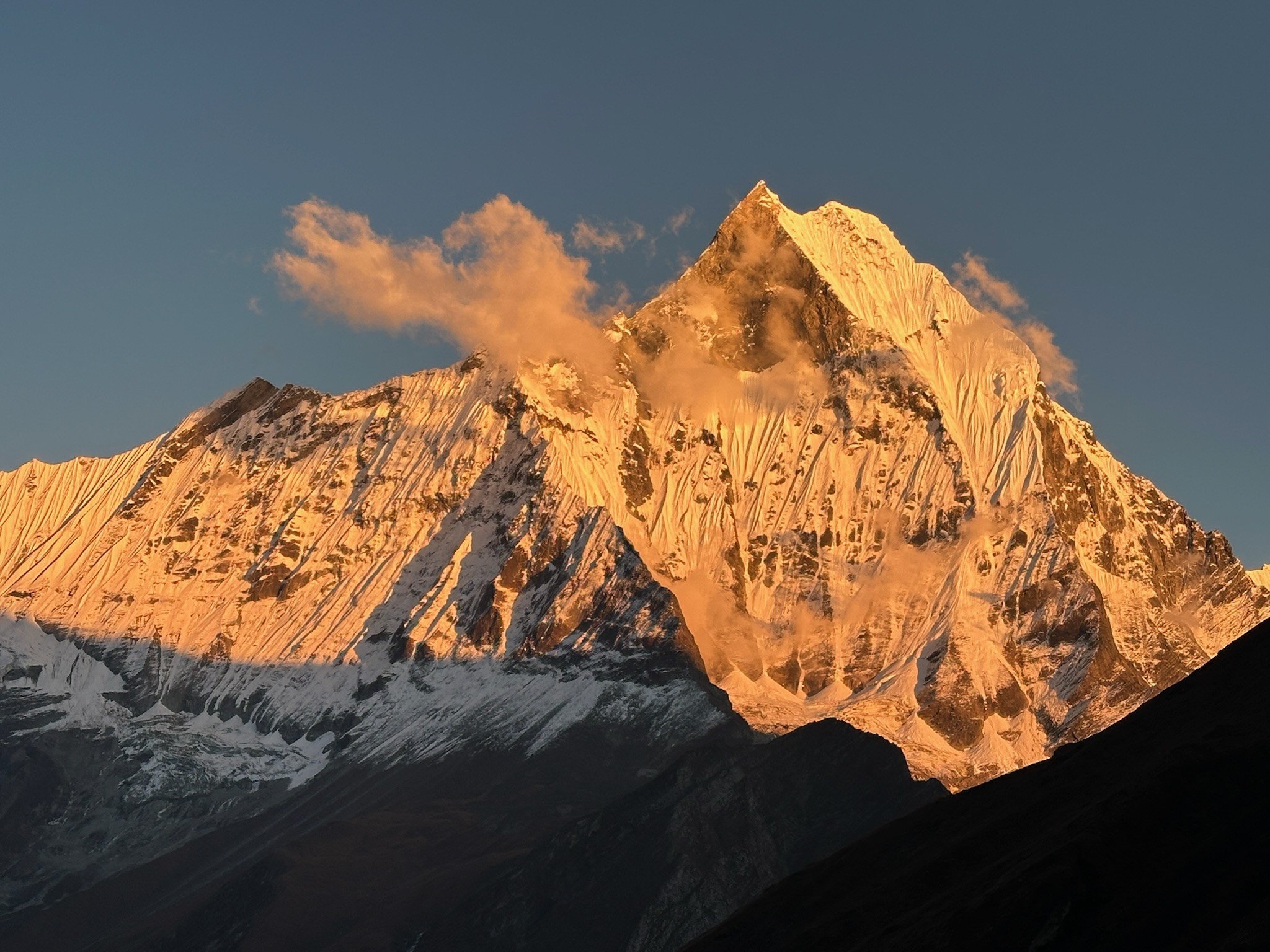
Machapuchare Base Camp Magic: Fishtail Mountain's Iconic Silhouette in Golden Hour Light
Actually, there’s something unreal about reaching Machhapuchhre Base Camp at 3,700 meters. You look up, and there it is—the Fishtail, Machhapuchhre itself, cutting right into the sky. When the golden hour hits, the whole peak glows. It’s hard not to stop and just stare. People pull out their cameras, trying to grab a bit of that magic—though honestly, no photo really does it justice.
In fact, the Machhapuchhre Base camp sits right beneath the mountain, so you feel close enough to touch it. Machhapuchhre’s twin summits rise up, sharp and sacred. To either side, Annapurna III and Gangapurna stand watch. You turn around, and you get this wild, 360-degree view—peaks everywhere, shadows shifting as the light changes. Sometimes it’s all fiery reds at sunset, sometimes it’s soft gold, but every time, it feels special. There’s this calm that settles over the camp, like the mountain’s letting you in on a secret. After the climb, golden hour at MBC isn’t just a reward—it’s what you came for.
Key Mountains and Views at Machhapuchhre Base Camp:
Machhapuchhre (6993m): Iconic Fishtail silhouette, golden hour highlight.
Gangapurna (7455m): Night and sunset views prominent.
Annapurna III (7555m): Joins the surrounding panorama.
Hiunchuli (6441m): Eastern side glimpses.
Annapurna South (7219m): Distant southern presence.
Aspect
Elevation
Primary Feature | Description
Machhapuchhre Base Camp
3700m
Machhapuchhre (6993m) Fishtail | Direct base views, golden light magic
Camp area
3700m
Gangapurna (7455m), Annapurna III (7555m) | 360° silhouettes in sunset glow
Golden hour spots
3700m
Fishtail in crimson/orange hues | Sunset often more spectacular than sunrise
Toward ABC
Ascent to 4130m
Enhanced Fishtail profile | Short walk for varied lighting.
MBC Golden Hour Highlights with Elevations:
Additional Facts on MBC Magic:
Ascent: From Deurali (3230m) to MBC (3700m), ~2-3 hours gradual.
Lighting: Golden hour (sunrise/sunset) transforms Fishtail dramatically.
Accommodation: Teahouses with direct peak views.
Transition: Prepares for final push to ABC (4130m).
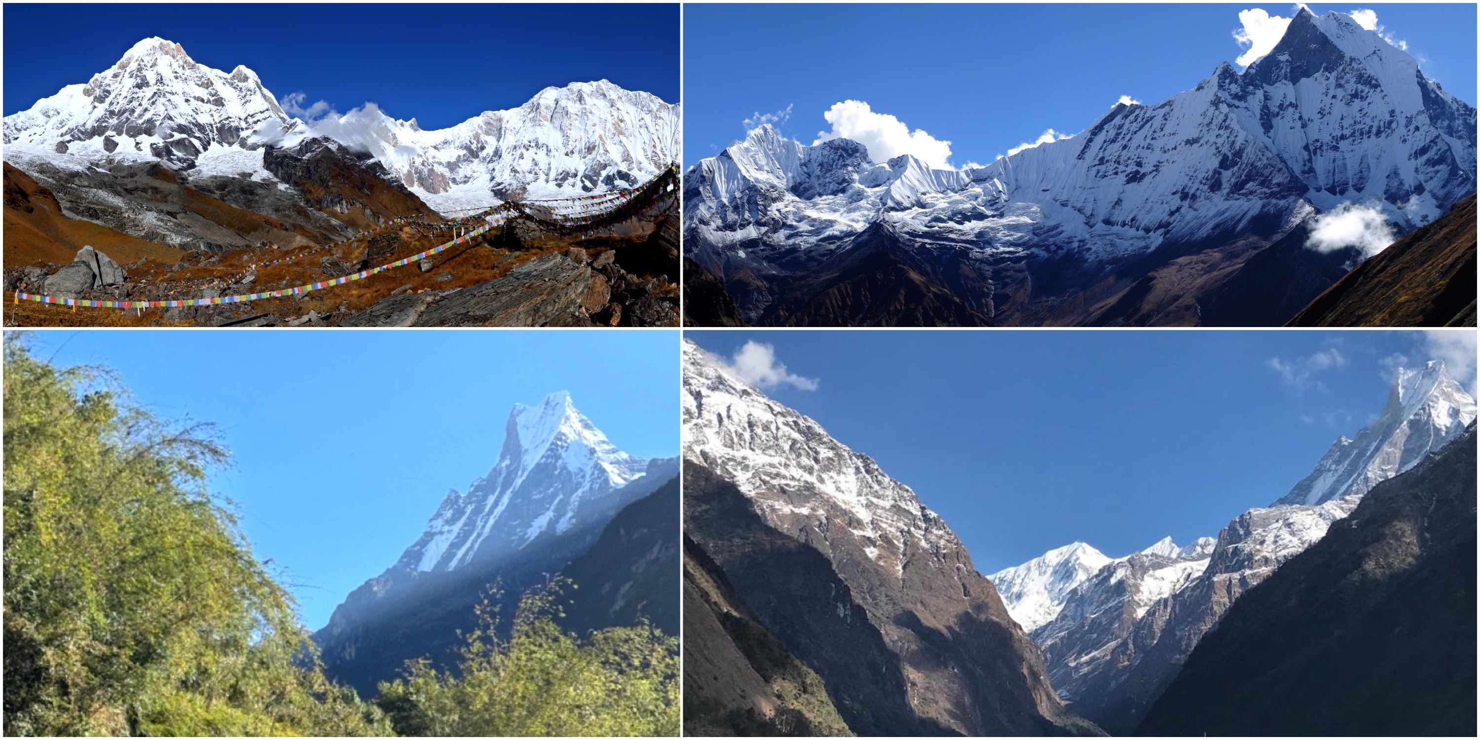
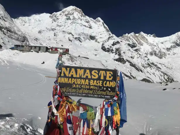
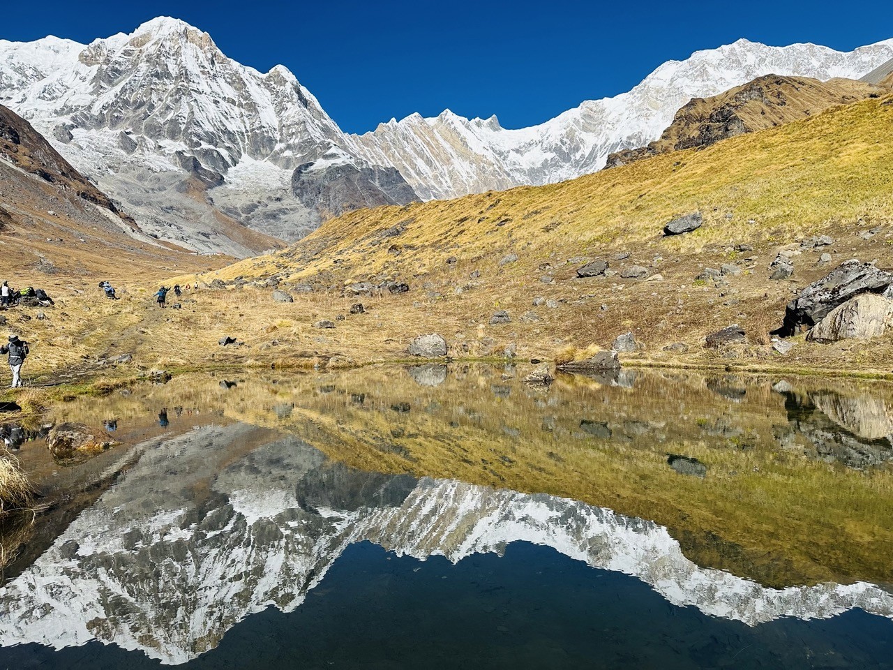
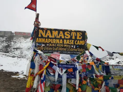
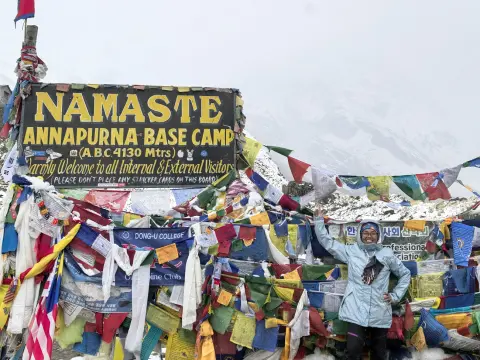
Annapurna Base Camp Apex: 360-Degree Surround of Towering Summits Including Annapurna I
Here, you finally make it to Annapurna Base Camp, perched at 4,130 meters. This is what you came for—the heart of the Himalayas, peaks everywhere you turn. Annapurna I towers above the north side, impossible to miss, while the rest of the Annapurna giants wrap around you in a perfect, snow-capped circle. Sunlight hits the glaciers and the whole place just glows. Standing there, you feel like you’ve stepped into a hidden amphitheater built by the mountains themselves. Every direction pulls your eyes to something bigger, wilder, more beautiful.
Honestly, reaching ABC feels like hitting the high note of the Annapurna Base Camp trek. The sense of achievement is real, and the view? It stays with you. Annapurna I is right in your face—8,091 meters of pure presence. Annapurna South stands guard to the south, and Machhapuchhre’s iconic fishtail slices the skyline with its sacred, untouched peak. Gangapurna and Annapurna III fill in the rest of the circle, sealing you into this wild, open basin. The scale here is hard to grasp until you see sunrise or sunset—the light changes everything, turning the whole arena golden or rose. It’s both vast and strangely personal, like the mountains are letting you in on a secret. Every step to get here pays off the moment you arrive.
Annapurna Base Camp Jeep Ride with Helicopter Return 7 days | 7 days
Annapurna I (8091m): Northern centerpiece, closest major 8000er view.
Annapurna South (7219m): Southern guardian, prominent from approach.
Machhapuchhre (6993m): Fishtail silhouette to the south.
Gangapurna (7455m): Western wall highlight.
Annapurna III (7555m): Eastern ridge presence.
Hiunchuli (6441m): Southeastern complement.
Direction
Primary Peak
Elevation Notable Feature
North - Annapurna I
8091m
Massive south face, glacier basin
South - Machhapuchhre
6993m
Iconic fishtail shape, sacred peak
Southwest - Annapurna South
7219m
Sharp pyramid profile
West - Gangapurna
7455m
Snowy ridge and lake views
East - Annapurna III
7555m
Rugged connecting ridges
Southeast - Hiunchuli
6441m
Steep rocky face.
360-Degree Panorama at ABC – Key Directions:
Facts on ABC Apex Experience:
Elevation gain to ABC: 4130m from sea-level start.
Sanctuary size: Natural bowl ~2-3 km across.
Best views: Clear dawn/sunset; clouds often lift midday.
Temperature: Often below freezing at night.
Sacred note: Annapurna I revered; no summit attempts from base.
Conclusion: Reflecting on the ABC Trek’s Mountain Masterpieces and Lasting Visual Memories
Actually, finishing the Annapurna Base Camp Trek, most people walk away with their heads—and hearts—full. The whole route feels like a parade of mountain masterpieces, each view stacking on the last, turning simple curiosity into flat-out awe. At first, those peaks just peek at you from a distance, but as you get closer, they tower above, impossible to forget. Trekkers don’t just snap a few photos—they carry home memories in full color, stitched together into one big, epic story.
Moreover, this trek doesn’t just offer pretty scenery. It’s got everything. Poon Hill(3210m) glows at sunrise. Tadapani(2630m) and the riverside paths build the drama, and when you finally reach MBC(3700m) and ABC(4130m), you’re right up close, surrounded by giants. Every stretch brings something new—a shift in light, a surprising view, the sheer scale of it all. All those moments blend together, shaping the way you see mountains, maybe even the world. By the end, you get why people want to come back, or at least sit quietly and remember. The Himalayas leave their mark, and those sights stick with you for good.
Signature Mountain Masterpieces of the Trek:
Annapurna I (8091m): Ultimate apex at ABC (4130m).
Machhapuchhre (6993m): Fishtail icon from MBC (3700m) and many points.
Annapurna South (7219m): Dominant from Poon Hill (3210m) to valley.
Dhaulagiri (8167m): Western sunrise giant at Poon Hill (3210m).
Gangapurna (7455m): Sanctuary wall highlight.
Stage
Key Viewpoint
Elevation | Highlight Memory
Gateway
Pokhara to Nayapul
827m–1070m | First teases of range.
Mid-trek
Poon Hill
3210m | Sunrise over Dhaulagiri & Annapurna.
Forested
Tadapani
2630m | Emerging Machhapuchhre ridgeline.
Valley
Modi Khola
2200m | Riverside Annapurna South &Hiunchuli.
Upper
Deurali–MBC
3230m–3700m | Close massif faces & fishtail.
Apex
ABC
4130m | 360° towering surround.
Trek Viewpoint Progression Summary:
Lasting Impact and Facts:
Total trek distance: ~110–115 km round trip.
Duration: 7–12 days depending on pace.
Seasons for best memories: October–November, March–May.
Personal growth: Altitude challenges build resilience.
Visual legacy: Photos and mental images last decades.
FAQs to support " Major Mountains Views on the Annapurna Base Camp Trek "
1. What are the major mountains that you can see on the Annapurna Base Camp Trek? The Annapurna Base Camp Trek is really amazing because you get to see a lot of mountains. You will see Annapurna I which's 8,091 meters tall Annapurna South which is 7,219 meters tall Machhapuchhre which is 6,993 meters tall Hiunchuli which is 6,441 meters tall Gangapurna which is 7,455 meters tall and Dhaulagiri which is 8,167 meters tall. These big mountains come into view as you walk from Poon Hill to the sanctuary. You will see villages and cool landscapes that will make your trip unforgettable. Our team is very good at making sure you are safe while you enjoy the views.
2. Which mountains can you see from Poon Hill when the sun comes up? Poon Hill is 3,210 meters tall. It is a great place to watch the sun come up. When the sun rises you will see Dhaulagiri, Annapurna South, Annapurna I, Machhapuchhre, Nilgiri and Hiunchuli looking golden. You can see than 30 mountains from here. The trees below are really colorful which makes the view even better. We think you should get to Poon Hill early so you can get a spot and see everything clearly.
3. How do the views of Machhapuchhre change as you walk on the Annapurna Base Camp Trek? Machhapuchhre is a cool mountain that you can see from a lot of places on the trek. At first it looks small from Pokhara. The start of the trail.. As you get closer to Tadapani you can see it better. When you get to Machhapuchhre Base Camp which's 3,700 meters tall you can see the mountain really clearly. The views of Machhapuchhre from the Annapurna Base Camp Trek are really beautiful. A lot of people think they are magical.
4. What do you see when you get to Annapurna Base Camp? Annapurna Base Camp is 4,130 meters tall. It is surrounded by really big mountains. You can see Annapurna I, Gangapurna, Annapurna III, Hiunchuli and Machhapuchhre from here. The glaciers sparkle in the sun which makes everything look really cool. Our team knows the Annapurna Base Camp Trek well and we think this is the best part of the trip.
5. When is the best time to see the mountains on the Annapurna Base Camp Trek? The best time to see the mountains clearly is in the autumn which's from September to November or in the spring which is from March to May. The sky is clear. You can see the mountains really well during these times. The weather is also stable. There are not many clouds. We think you should check the weather forecast before you go and bring clothes so you can enjoy the views.
6. Can you see Annapurna I and Annapurna South from the trail? Yes you can see Annapurna I and Annapurna South from the trail. Annapurna I looks really big from Deurali and Annapurna South looks really cool from Ghandruk, Poon Hill and Chhomrong. Our guides think these views are really special and they will make your trip more exciting. The mountains look really close and big from the trail which will make you want to keep walking.
7. Why is Deurali a place to see the mountains? Deurali is 3,230 meters tall. It is a great place to see the mountains. You can see Machhapuchhre and Annapurna South from here. The glaciers are really cool. Our team thinks Deurali is a place to stop and look at the mountains before you keep walking to the Annapurna Base Camp.
8. How good are the views from Machhapuchhre Base Camp? Machhapuchhre Base Camp is 3,700 meters tall. It is a really cool place to see the mountains. You can see Machhapuchhre clearly from here and it looks golden in the sun. You can also see Gangapurna and Annapurna III from here. Our team thinks Machhapuchhre Base Camp is one of the places to see the mountains, on the Annapurna Base Camp Trek.
9. Which mountains can you see from Tadapani and Chhomrong? The mountains you can see from Tadapani are really beautiful. You can see Machhapuchhre, Annapurna South and Annapurna III from there. These mountains look great against the trees behind them. Chhomrong is another spot. From Chhomrong you can see Annapurna South and Hiunchuli above the Modi Khola.
These are places to stop and look around during your trek. We have been guiding people for a time so we know the best spots. You can see the culture and the big mountains at the same time.
10. What do you need to know about seeing Dhaulagiri on the ABC Trek? Dhaulagiri is a big mountain. It is the highest mountain in the world. You can see it clearly from Poon Hill at sunrise. It looks really big. Adds a lot to the view. We think it is one of the mountain views in Nepal. You can see Dhaulagiri and the Annapurna range together which is really beautiful.
11. Can you see the mountains around you on the trek? Yes you can. Annapurna Base Camp is the place to see the mountains all around you. You can see the sanctuary from there. There are great spots too like Poon Hill. Our team plans the trek so you can see the views. We want to help you appreciate how big and beautiful the Himalayas are.
12. How do the forest sections of the trek show you the mountain views? The forest is very dense in some places. There are a lot of rhododendron and bamboo trees.. Then you come out of the forest and see the mountains. It is a surprise. You can see peaks like Gangapurna and Machhapuchhre. As you go higher there are trees so you can see more of the mountains. This makes the trek very exciting.
13. At what height can you see the views of the Himalayas? The best views are from up. Places like Deurali, MBC and ABC are great. You can see the mountains clearly from there.. You need to be careful and get used to the high altitude first. We make sure you are safe and healthy so you can enjoy the views.
14. Is Annapurna Base Camp a trek for beginners who want to see the mountains? Yes it is. The trek is not too hard. There are tea houses where you can rest. We have a lot of experience so we can help you have an fun trek. Many people have done this trek with us. Loved it. You can do it too.
15. How can you take photos of the mountains on the ABC Trek? You should bring a camera and extra batteries. A polarizer is also an idea. The best time to take photos is during the hours at Poon Hill, MBC and ABC. It is cold in the morning so dress warmly. Our guides know a lot about photography so they can give you tips, on how to take photos of the Himalayas.