[{"name":"Everest Base Camp Helicopter Tour","duration":"1","image_url":"https:\/\/www.havenholidaysnepal.com\/storage\/trip-galleries\/1\/thumb_6cd53005d75a86e373d31419d1b14d78.webp","offer_price":1195,"url":"https:\/\/www.havenholidaysnepal.com\/trips\/everest-base-camp-helicopter-tour"},{"name":"Everest Mountain Flight","duration":"1","image_url":"https:\/\/www.havenholidaysnepal.com\/storage\/trip-galleries\/4\/thumb_3b0b4f1d6f72b0ad224daf4752f2c6e0.jpg","offer_price":285,"url":"https:\/\/www.havenholidaysnepal.com\/trips\/everest-mountain-flight"},{"name":"Everest Short Trek","duration":"9","image_url":"https:\/\/www.havenholidaysnepal.com\/storage\/trip-galleries\/5\/thumb_BXPP3621.JPEG0.02033800 1727957098.webp","offer_price":995,"url":"https:\/\/www.havenholidaysnepal.com\/trips\/everest-short-trek"},{"name":"Gokyo Valley Trek","duration":"12","image_url":"https:\/\/www.havenholidaysnepal.com\/storage\/trip-galleries\/6\/thumb_10bc469b14731f23d3ce84a7092ad53f.jpg","offer_price":1195,"url":"https:\/\/www.havenholidaysnepal.com\/trips\/gokyo-valley-trek"},{"name":"15 days Annapurna Base Camp Trek","duration":"15","image_url":"https:\/\/www.havenholidaysnepal.com\/storage\/trip-galleries\/7\/thumb_87d1533bc45faf070990aef0579e4be4.jpg0.81855100 1728285496.webp","offer_price":785,"url":"https:\/\/www.havenholidaysnepal.com\/trips\/15-days-annapurna-base-camp-trek"},{"name":"Nepal Pilgrimage Tour","duration":"14","image_url":"https:\/\/www.havenholidaysnepal.com\/storage\/trip-galleries\/8\/thumb_02c3bcf2ad2e8a4c1703e90ae747b5f1.jpg","offer_price":1475,"url":"https:\/\/www.havenholidaysnepal.com\/trips\/nepal-pilgrimage-tour"},{"name":"UNESCO World Heritage Site Tour","duration":"10","image_url":"https:\/\/www.havenholidaysnepal.com\/storage\/trip-galleries\/9\/thumb_unesco-world-heritage-site-Lumbani-temple-buddhists-hindus-kathmandu-nepal0.36988600 17347617740.93089500 1737469667.webp","offer_price":715,"url":"https:\/\/www.havenholidaysnepal.com\/trips\/unesco-world-heritage-site-tour"},{"name":"Island Peak Climbing","duration":"16","image_url":"https:\/\/www.havenholidaysnepal.com\/storage\/trip-galleries\/11\/thumb_Island peak0.53947000 1734692503.webp","offer_price":2495,"url":"https:\/\/www.havenholidaysnepal.com\/trips\/island-peak-climbing"},{"name":"Upper Mustang Trek","duration":"18","image_url":"https:\/\/www.havenholidaysnepal.com\/storage\/trip-galleries\/12\/thumb_upper mustang 7 Oct-2024.jpg0.95398900 1728286166.webp","offer_price":2995,"url":"https:\/\/www.havenholidaysnepal.com\/trips\/upper-mustang-trek"},{"name":"Annapurna Circuit Trek","duration":"16","image_url":"https:\/\/www.havenholidaysnepal.com\/storage\/trip-galleries\/15\/thumb_tibetan-flags.jpg0.04843900 1728289138.webp","offer_price":985,"url":"https:\/\/www.havenholidaysnepal.com\/trips\/annapurna-circuit-trek"},{"name":"Gosainkunda Lake Trek","duration":"10","image_url":"https:\/\/www.havenholidaysnepal.com\/storage\/trip-galleries\/16\/thumb_5A8083B3-C007-41A8-853F-D0C37C97D235_1_105_c.jpeg0.52581200 1731845258.webp","offer_price":595,"url":"https:\/\/www.havenholidaysnepal.com\/trips\/gosainkunda-lake-trek"},{"name":"Zip-lining in Pokhara and Dhulikhel","duration":"1","image_url":"https:\/\/www.havenholidaysnepal.com\/storage\/trip-galleries\/18\/thumb_215f765e2ebc995dd5c800b4bfdbacc3.jpg","offer_price":82,"url":"https:\/\/www.havenholidaysnepal.com\/trips\/zip-lining-in-pokhara-and-dhulikhel"},{"name":"Annapurna Heli Tour","duration":"1","image_url":"https:\/\/www.havenholidaysnepal.com\/storage\/trip-galleries\/19\/thumb_d71a6bbb9fd4da8d1b567a5cdbdec85d.jpg","offer_price":555,"url":"https:\/\/www.havenholidaysnepal.com\/trips\/annapurna-heli-tour"},{"name":"Paragliding in Pokhara","duration":"1","image_url":"https:\/\/www.havenholidaysnepal.com\/storage\/trip-galleries\/20\/thumb_de788d2dd9726783431f882c007efae1.jpg","offer_price":65,"url":"https:\/\/www.havenholidaysnepal.com\/trips\/paragliding-in-pokhara"},{"name":"Ultra-Flight in Pokhara","duration":"1","image_url":"https:\/\/www.havenholidaysnepal.com\/storage\/trip-galleries\/21\/thumb_e27a9fb572a5c21611bb2a3c18e4b8f0.jpeg","offer_price":175,"url":"https:\/\/www.havenholidaysnepal.com\/trips\/ultra-flight-in-pokhara"},{"name":"Sarangkot Hiking","duration":"1","image_url":"https:\/\/www.havenholidaysnepal.com\/storage\/trip-galleries\/22\/thumb_100ef822fea19987166c6c1366215f15.jpg","offer_price":55,"url":"https:\/\/www.havenholidaysnepal.com\/trips\/sarangkot-hiking"},{"name":"Mera Peak Climbing","duration":"18","image_url":"https:\/\/www.havenholidaysnepal.com\/storage\/trip-galleries\/24\/thumb_d16ae3895f678cf26ffbf2455f541fb5.jpg0.31883400 1732617790.webp","offer_price":2475,"url":"https:\/\/www.havenholidaysnepal.com\/trips\/mera-peak-climbing"},{"name":"Lower Dolpo Trek","duration":"18","image_url":"https:\/\/www.havenholidaysnepal.com\/storage\/trip-galleries\/26\/thumb_Dolpo Galary - 1.JPG0.37725200 1727939952.webp","offer_price":2995,"url":"https:\/\/www.havenholidaysnepal.com\/trips\/lower-dolpo-trek"},{"name":"Nagarkot Sunrise\/Sunset Tour","duration":"1","image_url":"https:\/\/www.havenholidaysnepal.com\/storage\/trip-galleries\/27\/thumb_5147a5532644283a380f2e86f3857c13.jpg0.17748000 1728488108.webp","offer_price":30,"url":"https:\/\/www.havenholidaysnepal.com\/trips\/nagarkot-sunrise-sunset-tour"},{"name":"16 day Everest Base Camp Trek","duration":"16","image_url":"https:\/\/www.havenholidaysnepal.com\/storage\/trip-galleries\/28\/thumb_IMG_4311.JPG0.64984800 1727942213.webp","offer_price":1475,"url":"https:\/\/www.havenholidaysnepal.com\/trips\/16-day-everest-base-camp-trek"},{"name":"Ghorepani Poon Hill trek with Jungle Safari and Trishuli River Rafting -13 days","duration":"13","image_url":"https:\/\/www.havenholidaysnepal.com\/storage\/trip-galleries\/29\/thumb_Ghorepani Poon hill.jpg0.48460800 1728281439.webp","offer_price":795,"url":"https:\/\/www.havenholidaysnepal.com\/trips\/ghorepani-poon-hill-trek-with-jungle-safari-and-trishuli-river-rafting--13-days"},{"name":"Mardi Himal Trek","duration":"12","image_url":"https:\/\/www.havenholidaysnepal.com\/storage\/trip-galleries\/30\/thumb_s1.jpg0.62112600 1728200721.webp","offer_price":795,"url":"https:\/\/www.havenholidaysnepal.com\/trips\/mardi-himal-trek"},{"name":"Langtang Valley Trekking","duration":"10","image_url":"https:\/\/www.havenholidaysnepal.com\/storage\/trip-galleries\/31\/thumb_IMG_4702.JPG0.84916500 1727958504.webp","offer_price":685,"url":"https:\/\/www.havenholidaysnepal.com\/trips\/langtang-valley-trekking"},{"name":"Real Adventure Tour in Nepal","duration":"9","image_url":"https:\/\/www.havenholidaysnepal.com\/storage\/trip-galleries\/32\/thumb_ebd1b8cc78d90abe8b9003dd9a2f25bf.jpg0.82151300 1728213516.webp","offer_price":695,"url":"https:\/\/www.havenholidaysnepal.com\/trips\/real-adventure-tour-in-nepal"},{"name":"Luxury Tour in Nepal","duration":"10","image_url":"https:\/\/www.havenholidaysnepal.com\/storage\/trip-galleries\/33\/thumb_8574e61b252b18676b042caf30d830df.jpg","offer_price":1675,"url":"https:\/\/www.havenholidaysnepal.com\/trips\/luxury-tour-in-nepal"},{"name":"Luxury Everest Panorama Trek With EBC Heli Sightseeing","duration":"8","image_url":"https:\/\/www.havenholidaysnepal.com\/storage\/trip-galleries\/34\/thumb_URZL2397.JPEG0.01209600 1728027820.webp","offer_price":2575,"url":"https:\/\/www.havenholidaysnepal.com\/trips\/luxury-everest-panorama-trek-with-ebc-heli-sightseeing"},{"name":"13 day Everest Base Camp Trek with Helicopter","duration":"13","image_url":"https:\/\/www.havenholidaysnepal.com\/storage\/trip-galleries\/35\/thumb_IMG_4292.JPG0.70131500 1728029276.webp","offer_price":2095,"url":"https:\/\/www.havenholidaysnepal.com\/trips\/13-day-everest-base-camp-trek-with-helicopter"},{"name":"Manaslu Circuit Trek","duration":"16","image_url":"https:\/\/www.havenholidaysnepal.com\/storage\/trip-galleries\/36\/thumb_Mt Manaslu 03-Oct-2024.jpg0.65804900 1727938470.webp","offer_price":955,"url":"https:\/\/www.havenholidaysnepal.com\/trips\/manaslu-circuit-trek"},{"name":"Kanchenjunga Base Camp Trek","duration":"21","image_url":"https:\/\/www.havenholidaysnepal.com\/storage\/trip-galleries\/37\/thumb_Kanchanjunga Trek -!.jpg0.54744400 1727938497.webp","offer_price":2275,"url":"https:\/\/www.havenholidaysnepal.com\/trips\/kanchenjunga-base-camp-trek"},{"name":"Ganesh Himal and Sing-La Trek","duration":"18","image_url":"https:\/\/www.havenholidaysnepal.com\/storage\/trip-galleries\/38\/thumb_Ganesh Himal slider-1.jpg0.43764500 1727937722.webp","offer_price":2975,"url":"https:\/\/www.havenholidaysnepal.com\/trips\/ganesh-himal-and-sing-la-trek"},{"name":"Island Peak Climb with Everest Base Camp Trek","duration":"21","image_url":"https:\/\/www.havenholidaysnepal.com\/storage\/trip-galleries\/39\/thumb_2be428730fe83525bc85a010564f99de.jpg","offer_price":2750,"url":"https:\/\/www.havenholidaysnepal.com\/trips\/island-peak-climb-with-everest-base-camp-trek"},{"name":"Students' Adventure Tour in Nepal","duration":"12","image_url":"https:\/\/www.havenholidaysnepal.com\/storage\/trip-galleries\/41\/thumb_a926d22fbfe08cba271c41ac289b3fd2.jpg","offer_price":995,"url":"https:\/\/www.havenholidaysnepal.com\/trips\/students-adventure-tour-in-nepal"},{"name":"7 Day Poonhill Trek","duration":"7","image_url":"https:\/\/www.havenholidaysnepal.com\/storage\/trip-galleries\/42\/thumb_6196bd69036473293a2c24cc21ed57d7.jpg0.10880600 1728205378.webp","offer_price":555,"url":"https:\/\/www.havenholidaysnepal.com\/trips\/7-day-poonhill-trek"},{"name":"7 Days Annapurna Base Camp Trek","duration":"7","image_url":"https:\/\/www.havenholidaysnepal.com\/storage\/trip-galleries\/43\/thumb_IMG_2214.JPG0.08204900 1728202033.webp","offer_price":355,"url":"https:\/\/www.havenholidaysnepal.com\/trips\/7-days-annapurna-base-camp-trek"},{"name":"3 days Poonhill Trek","duration":"3","image_url":"https:\/\/www.havenholidaysnepal.com\/storage\/trip-galleries\/44\/thumb_Poon hill.jpg0.60816600 1731412954.webp","offer_price":165,"url":"https:\/\/www.havenholidaysnepal.com\/trips\/3-days-poonhill-trek"},{"name":"Poon Hill Luxury Trek with Chitwan-12 days","duration":"12","image_url":"https:\/\/www.havenholidaysnepal.com\/storage\/trip-galleries\/45\/thumb_Poom hill.jpg0.52074500 1730180532.webp","offer_price":1175,"url":"https:\/\/www.havenholidaysnepal.com\/trips\/poon-hill-luxury-trek-with-chitwan-12-days"},{"name":"Everest Luxury Trek-7 days","duration":"7","image_url":"https:\/\/www.havenholidaysnepal.com\/storage\/trip-galleries\/46\/thumb_ACRX9330.JPEG0.93236200 1728031275.webp","offer_price":1975,"url":"https:\/\/www.havenholidaysnepal.com\/trips\/everest-luxury-trek-7-days"},{"name":"Hindu Pilgrimage Tour in Nepal-10 days","duration":"10","image_url":"https:\/\/www.havenholidaysnepal.com\/storage\/trip-galleries\/47\/thumb_a94bf96a4d31decb419f6f828a3280d2.jpg","offer_price":995,"url":"https:\/\/www.havenholidaysnepal.com\/trips\/hindu-pilgrimage-tour-in-nepal-10-days"},{"name":"Everest Base Camp Short Trek-12 days","duration":"12","image_url":"https:\/\/www.havenholidaysnepal.com\/storage\/trip-galleries\/48\/thumb_IMG_4311.JPG0.52680100 1727945154.webp","offer_price":995,"url":"https:\/\/www.havenholidaysnepal.com\/trips\/everest-base-camp-short-trek-12-days"},{"name":"Everest Base Camp Hike 12 Days","duration":"12","image_url":"https:\/\/www.havenholidaysnepal.com\/storage\/trip-galleries\/49\/thumb_IMG_4260.JPG0.51729100 1728061234.webp","offer_price":1295,"url":"https:\/\/www.havenholidaysnepal.com\/trips\/everest-base-camp-hike-12-days"},{"name":"11 Days Everest Base Camp Trek","duration":"11","image_url":"https:\/\/www.havenholidaysnepal.com\/storage\/trip-galleries\/50\/thumb_IMG_4249.JPG0.21392500 1727946959.webp","offer_price":985,"url":"https:\/\/www.havenholidaysnepal.com\/trips\/11-days-everest-base-camp-trek"},{"name":"6 Days Annapurna Base Camp Trek","duration":"6","image_url":"https:\/\/www.havenholidaysnepal.com\/storage\/trip-galleries\/51\/thumb_6 days Abc.jpg0.58185400 1728200798.webp","offer_price":285,"url":"https:\/\/www.havenholidaysnepal.com\/trips\/6-days-annapurna-base-camp-trek"},{"name":"Annapurna Base Camp Trek","duration":"8","image_url":"https:\/\/www.havenholidaysnepal.com\/storage\/trip-galleries\/52\/thumb_IMG_2214.JPG0.29415700 1729487656.webp","offer_price":585,"url":"https:\/\/www.havenholidaysnepal.com\/trips\/annapurna-base-camp-trek"},{"name":"Everest Base Camp Trek with Helicopter Fly Out 10 Days","duration":"10","image_url":"https:\/\/www.havenholidaysnepal.com\/storage\/trip-galleries\/53\/thumb_IMG_4328.JPG0.52056600 1728058444.webp","offer_price":1875,"url":"https:\/\/www.havenholidaysnepal.com\/trips\/everest-base-camp-trek-with-helicopter-fly-out-10-days"},{"name":"Everest Base Camp Trek 14 Days","duration":"14","image_url":"https:\/\/www.havenholidaysnepal.com\/storage\/trip-galleries\/54\/thumb_Everest Base Camp Trek 14 days Oct 3 2024.JPG0.43202700 1727939745.webp","offer_price":1455,"url":"https:\/\/www.havenholidaysnepal.com\/trips\/everest-base-camp-trek-14-days"},{"name":"ABC Trek with Poonhill 11 Days","duration":"11","image_url":"https:\/\/www.havenholidaysnepal.com\/storage\/trip-galleries\/55\/thumb_ABC with fishtail.JPG0.21441100 1728277965.webp","offer_price":555,"url":"https:\/\/www.havenholidaysnepal.com\/trips\/abc-trek-with-poonhill-11-days"},{"name":"Muldai Hill Trek 9 Days","duration":"9","image_url":"https:\/\/www.havenholidaysnepal.com\/storage\/trip-galleries\/56\/thumb_7efee59f0a8c6817c8255bd2b9f3539d.jpeg0.19479300 1728213091.webp","offer_price":675,"url":"https:\/\/www.havenholidaysnepal.com\/trips\/muldai-hill-trek-9-days"},{"name":"Mardi Himal Trek 6 days","duration":"6","image_url":"https:\/\/www.havenholidaysnepal.com\/storage\/trip-galleries\/57\/thumb_slider 1.jpeg0.36909700 1728184981.webp","offer_price":590,"url":"https:\/\/www.havenholidaysnepal.com\/trips\/mardi-himal-trek-6-days"},{"name":"Mardi Himal Trek 7 days","duration":"7","image_url":"https:\/\/www.havenholidaysnepal.com\/storage\/trip-galleries\/58\/thumb_slider1.jpg0.61666600 1728206414.webp","offer_price":620,"url":"https:\/\/www.havenholidaysnepal.com\/trips\/mardi-himal-trek-7-days"},{"name":"Mardi Himal Trek 8 Days","duration":"8","image_url":"https:\/\/www.havenholidaysnepal.com\/storage\/trip-galleries\/59\/thumb_sli1.jpg0.38569100 1728206631.webp","offer_price":695,"url":"https:\/\/www.havenholidaysnepal.com\/trips\/mardi-himal-trek-8-days"},{"name":"14 Days Manaslu Trek","duration":"14","image_url":"https:\/\/www.havenholidaysnepal.com\/storage\/trip-galleries\/60\/thumb_sunrise-mt-manaslu-during-manaslu-circuit-larke-pass-trekking-himalaya-nepal (1)0.81855800 1738673284.webp","offer_price":885,"url":"https:\/\/www.havenholidaysnepal.com\/trips\/14-days-manaslu-trek"},{"name":"Dhampus-Sarangkot Trek with Chitwan 8 days","duration":"8","image_url":"https:\/\/www.havenholidaysnepal.com\/storage\/trip-galleries\/61\/thumb_Sarangkot Bhangyang.jpg0.75461400 1728210333.webp","offer_price":790,"url":"https:\/\/www.havenholidaysnepal.com\/trips\/dhampus-sarangkot-trek-with-chitwan-8-days"},{"name":"7 Days Golden Triangle Tour","duration":"7","image_url":"https:\/\/www.havenholidaysnepal.com\/storage\/trip-galleries\/62\/thumb_311ce1d117ee0ba75402a7c301bcdf830.73532400 1739179809.webp","offer_price":845,"url":"https:\/\/www.havenholidaysnepal.com\/trips\/7-days-golden-triangle-tour"},{"name":"Annapurna Circuit Trek 12 days","duration":"12","image_url":"https:\/\/www.havenholidaysnepal.com\/storage\/trip-galleries\/63\/thumb_IMG_20161024_092237.jpg0.57796600 1728289938.webp","offer_price":695,"url":"https:\/\/www.havenholidaysnepal.com\/trips\/annapurna-circuit-trek-12-days"},{"name":"Everest Base Camp Budget Trek 16 Days","duration":"16","image_url":"https:\/\/www.havenholidaysnepal.com\/storage\/trip-galleries\/64\/thumb_IMG_4423.JPG0.92579200 1728144669.webp","offer_price":958,"url":"https:\/\/www.havenholidaysnepal.com\/trips\/everest-base-camp-budget-trek-16-days"},{"name":"Poonhill Budget Trek 7 Days","duration":"7","image_url":"https:\/\/www.havenholidaysnepal.com\/storage\/trip-galleries\/65\/thumb_5be067852d0c5228d6f3155bc425c6b5.jpg","offer_price":395,"url":"https:\/\/www.havenholidaysnepal.com\/trips\/poonhill-budget-trek-7-days"},{"name":"Annapurna Base Camp Budget Trek 8 Days","duration":"8","image_url":"https:\/\/www.havenholidaysnepal.com\/storage\/trip-galleries\/66\/thumb_Pokhara.jpg0.16188000 1728212001.webp","offer_price":375,"url":"https:\/\/www.havenholidaysnepal.com\/trips\/annapurna-base-camp-budget-trek-8-days"},{"name":"The Real UNESCO Seven World Heritage Tour in Kathmandu 4 days","duration":"4","image_url":"https:\/\/www.havenholidaysnepal.com\/storage\/trip-galleries\/67\/thumb_Baudha Stupa.JPG0.63906900 1728201021.webp","offer_price":380,"url":"https:\/\/www.havenholidaysnepal.com\/trips\/the-real-unesco-seven-world-heritage-tour-in-kathmandu-4-days"},{"name":"Everest Base Camp Jeep Ride with Helicopter Return","duration":"14","image_url":"https:\/\/www.havenholidaysnepal.com\/storage\/trip-galleries\/68\/thumb_788ee5b63a6efb6f3c3d048b4270daca.JPG","offer_price":1895,"url":"https:\/\/www.havenholidaysnepal.com\/trips\/everest-base-camp-jeep-ride-with-helicopter-return"},{"name":"Annapurna Base Camp Jeep Ride with Helicopter Return 7 days","duration":"7","image_url":"https:\/\/www.havenholidaysnepal.com\/storage\/trip-galleries\/69\/thumb_abc jeep.jpg0.10280600 1728204064.webp","offer_price":1455,"url":"https:\/\/www.havenholidaysnepal.com\/trips\/annapurna-base-camp-jeep-ride-with-helicopter-return-7-days"},{"name":"Everest Base Camp Trek","duration":"15","image_url":"https:\/\/www.havenholidaysnepal.com\/storage\/trip-galleries\/70\/thumb_Everest Base Camp Trek 3 oct- 2024.JPG0.58445300 1727941472.webp","offer_price":1575,"url":"https:\/\/www.havenholidaysnepal.com\/trips\/everest-base-camp-trek"},{"name":"7 UNESCO World Heritage Tour Kathmandu 2 days","duration":"2","image_url":"https:\/\/www.havenholidaysnepal.com\/storage\/trip-galleries\/72\/thumb_Bhaktipur 3.jpg0.05559600 1728201496.webp","offer_price":150,"url":"https:\/\/www.havenholidaysnepal.com\/trips\/7-unesco-world-heritage-tour-kathmandu-2-days"},{"name":"Day Tour to UNESCO Heritage Sites","duration":"1","image_url":"https:\/\/www.havenholidaysnepal.com\/storage\/trip-galleries\/73\/thumb_228A1018.jpg0.79892500 1728199793.webp","offer_price":55,"url":"https:\/\/www.havenholidaysnepal.com\/trips\/day-tour-to-unesco-heritage-sites"},{"name":"Golden Triangle Tour in Nepal","duration":"8","image_url":"https:\/\/www.havenholidaysnepal.com\/storage\/trip-galleries\/74\/thumb_f54139cf9100f00015ffe0400687e946.webp","offer_price":588,"url":"https:\/\/www.havenholidaysnepal.com\/trips\/golden-triangle-tour-in-nepal"},{"name":"Everest Base Camp Honeymoon Tour by Helicopter with Pokhara","duration":"7 days","image_url":"https:\/\/www.havenholidaysnepal.com\/storage\/trip-galleries\/76\/thumb_RJTL7517.JPEG0.40261600 1731499989.webp","offer_price":9999,"url":"https:\/\/www.havenholidaysnepal.com\/trips\/everest-base-camp-honeymoon-tour-by-helicopter-with-pokhara"},{"name":"Yoga and Meditation Retreat Tour in Nepal","duration":"10 days","image_url":"https:\/\/www.havenholidaysnepal.com\/storage\/trip-galleries\/77\/thumb_decf8e33-6617-4400-9df0-63bf75509adf.JPG0.51948300 1731574810.webp","offer_price":2575,"url":"https:\/\/www.havenholidaysnepal.com\/trips\/yoga-and-meditation-retreat-tour-in-nepal"},{"name":"Chisapani-Nagarkot Trek","duration":"3","image_url":"https:\/\/www.havenholidaysnepal.com\/storage\/trip-galleries\/78\/thumb_0b64dfceaeab48ac36d685476bdebafb.webp","offer_price":165,"url":"https:\/\/www.havenholidaysnepal.com\/trips\/chisapani-nagarkot-trek"},{"name":"Chitwan Jungle Safari Tour","duration":"2","image_url":"https:\/\/www.havenholidaysnepal.com\/storage\/trip-galleries\/79\/thumb_IMG_1696.JPG0.28467800 1733054554.webp","offer_price":175,"url":"https:\/\/www.havenholidaysnepal.com\/trips\/chitwan-jungle-safari-tour"},{"name":"Kailash Overland Tour","duration":"16","image_url":"https:\/\/www.havenholidaysnepal.com\/storage\/trip-galleries\/80\/thumb_PA2605230.68496700 1735818657.webp","offer_price":2495,"url":"https:\/\/www.havenholidaysnepal.com\/trips\/kailash-overland-tour"},{"name":"4 nights 5 days Bhutan Tour","duration":"5","image_url":"https:\/\/www.havenholidaysnepal.com\/storage\/trip-galleries\/81\/thumb_PB0508470.23069500 1735828937.webp","offer_price":1265,"url":"https:\/\/www.havenholidaysnepal.com\/trips\/4-nights-5-days-bhutan-tour"},{"name":"Everest Base Camp Trek Without Flying","duration":"16","image_url":"https:\/\/www.havenholidaysnepal.com\/storage\/trip-galleries\/82\/thumb_308b054484eddc042e092e1ae2ae5586.webp","offer_price":685,"url":"https:\/\/www.havenholidaysnepal.com\/trips\/everest-base-camp-trek-without-flying"},{"name":"Everest Base Camp Trek by Land","duration":"16","image_url":"https:\/\/www.havenholidaysnepal.com\/storage\/trip-galleries\/83\/thumb_8f0f2784a3ae7343d193b64fe8d47c96.webp","offer_price":675,"url":"https:\/\/www.havenholidaysnepal.com\/trips\/everest-base-camp-trek-by-land"},{"name":"Everest Base Camp Trek by Jeep","duration":"16","image_url":"https:\/\/www.havenholidaysnepal.com\/storage\/trip-galleries\/84\/thumb_f82b3acdfc933bc3e0197624c001b0a6.webp","offer_price":675,"url":"https:\/\/www.havenholidaysnepal.com\/trips\/everest-base-camp-trek-by-jeep"},{"name":"Everest Base Camp Trek without Lukla Flight","duration":"16","image_url":"https:\/\/www.havenholidaysnepal.com\/storage\/trip-galleries\/85\/thumb_2d0acc76dc958e3122a3745074989914.webp","offer_price":675,"url":"https:\/\/www.havenholidaysnepal.com\/trips\/everest-base-camp-trek-without-lukla-flight"},{"name":"Langtang Valley Trek","duration":"7","image_url":"https:\/\/www.havenholidaysnepal.com\/storage\/trip-galleries\/86\/thumb_a845db06c5feada1478e8aed659fce97.webp","offer_price":199,"url":"https:\/\/www.havenholidaysnepal.com\/trips\/langtang-valley-trek"},{"name":"Everest Base Camp Trek with Gokyo Lake","duration":"17","image_url":"https:\/\/www.havenholidaysnepal.com\/storage\/trip-galleries\/87\/thumb_c6aa32f7654f2eda78134bc84ac70b79.webp","offer_price":1885,"url":"https:\/\/www.havenholidaysnepal.com\/trips\/everest-base-camp-trek-with-gokyo-lake"},{"name":"Everest Three Passes Trek","duration":"19","image_url":"https:\/\/www.havenholidaysnepal.com\/storage\/trip-galleries\/88\/thumb_db5364eaab56f5755da55868f8ca4258.webp","offer_price":1735,"url":"https:\/\/www.havenholidaysnepal.com\/trips\/everest-three-passes-trek"},{"name":"Annapurna Base Camp Trek From Pokhara","duration":"5","image_url":"https:\/\/www.havenholidaysnepal.com\/storage\/trip-galleries\/89\/thumb_49c813cf1054ff06108963924a78ee88.webp","offer_price":255,"url":"https:\/\/www.havenholidaysnepal.com\/trips\/annapurna-base-camp-trek-from-pokhara"},{"name":"Sarangkot Sunrise Tour from Pokhara","duration":"1","image_url":"https:\/\/www.havenholidaysnepal.com\/storage\/trip-galleries\/90\/thumb_932d995b8fb702634a23e8f9a0432c6e.webp","offer_price":35,"url":"https:\/\/www.havenholidaysnepal.com\/trips\/sarangkot-sunrise-tour-from-pokhara"},{"name":"Langtang Valley Trek-8 days","duration":"8","image_url":"https:\/\/www.havenholidaysnepal.com\/storage\/trip-galleries\/91\/thumb_81d3d0a6979c9ed01f65d5ade53820b2.webp","offer_price":250,"url":"https:\/\/www.havenholidaysnepal.com\/trips\/langtang-valley-trek-8-days"},{"name":"Manaslu Circuit Trek 12 days","duration":"12","image_url":"https:\/\/www.havenholidaysnepal.com\/storage\/trip-galleries\/92\/thumb_d8251bbef0c8a246a02bda5c150a27c2.webp","offer_price":675,"url":"https:\/\/www.havenholidaysnepal.com\/trips\/manaslu-circuit-trek-12-days"},{"name":"2 Days Poon Hill Trek","duration":"2","image_url":"https:\/\/www.havenholidaysnepal.com\/storage\/trip-galleries\/93\/thumb_9d8fa8f60767538857d6c7cb3a7fee8b.webp","offer_price":150,"url":"https:\/\/www.havenholidaysnepal.com\/trips\/2-days-poon-hill-trek"},{"name":"Upper Mustang Jeep Tour","duration":"6","image_url":"https:\/\/www.havenholidaysnepal.com\/storage\/trip-galleries\/94\/thumb_9a3098a6c860b87ad3339773ef5435b9.webp","offer_price":1095,"url":"https:\/\/www.havenholidaysnepal.com\/trips\/upper-mustang-jeep-tour"},{"name":"Tsum Valley Trek","duration":"11","image_url":"https:\/\/www.havenholidaysnepal.com\/storage\/trip-galleries\/95\/thumb_704a6a1eb293553827633dbd8ad7d22c.webp","offer_price":775,"url":"https:\/\/www.havenholidaysnepal.com\/trips\/tsum-valley-trek"},{"name":"Mardi Himal Trek from Pokhara","duration":"4","image_url":"https:\/\/www.havenholidaysnepal.com\/storage\/trip-galleries\/96\/thumb_c92e9ee49c2564a11c7a9ba593439efc.webp","offer_price":295,"url":"https:\/\/www.havenholidaysnepal.com\/trips\/mardi-himal-trek-from-pokhara"},{"name":"4 Days Poon Hill Trek","duration":"4","image_url":"https:\/\/www.havenholidaysnepal.com\/storage\/trip-galleries\/97\/thumb_c349e182edd0858f3e3409d945f0d2ec.webp","offer_price":215,"url":"https:\/\/www.havenholidaysnepal.com\/trips\/4-days-poon-hill-trek"},{"name":"Poon Hill Sunrise Jeep Tour from Pokhara","duration":"2","image_url":"https:\/\/www.havenholidaysnepal.com\/storage\/trip-galleries\/98\/thumb_509875052b16f6f9156db386e3592eb8.webp","offer_price":260,"url":"https:\/\/www.havenholidaysnepal.com\/trips\/poon-hill-sunrise-jeep-tour-from-pokhara"},{"name":"Muktinath Jeep Tour from Pokhara","duration":"3","image_url":"https:\/\/www.havenholidaysnepal.com\/storage\/trip-galleries\/99\/thumb_1651790cb7422703fe86d472a35d4f90.webp","offer_price":255,"url":"https:\/\/www.havenholidaysnepal.com\/trips\/muktinath-jeep-tour-from-pokhara"},{"name":"Ghorepani Poon Hill Trek from Pokhara","duration":"5","image_url":"https:\/\/www.havenholidaysnepal.com\/storage\/trip-galleries\/100\/thumb_27fa62452af4ea8e08544aaa035cc446.webp","offer_price":295,"url":"https:\/\/www.havenholidaysnepal.com\/trips\/ghorepani-poon-hill-trek-from-pokhara"},{"name":"Ghandruk, Poon Hill, Muktinath and Upper Mustang Tour","duration":"7 days","image_url":"https:\/\/www.havenholidaysnepal.com\/storage\/trip-galleries\/101\/thumb_a7dd15032cd9693005233b1df7dc63d3.webp","offer_price":685,"url":"https:\/\/www.havenholidaysnepal.com\/trips\/ghandruk-poon-hill-muktinath-and-upper-mustang-tour"},{"name":"Nar Phu Valley Trek with Annapurna Circuit","duration":"16 days","image_url":"https:\/\/www.havenholidaysnepal.com\/storage\/trip-galleries\/102\/thumb_21f5af1d6f698a6898b64413bcc19c69.webp","offer_price":1395,"url":"https:\/\/www.havenholidaysnepal.com\/trips\/nar-phu-valley-trek-with-annapurna-circuit"},{"name":"Poon Hill-Jhino Danda Hot Spring Trek","duration":"4","image_url":"https:\/\/www.havenholidaysnepal.com\/storage\/trip-galleries\/103\/thumb_b1a8563edaf102468aab613332282c6c.webp","offer_price":215,"url":"https:\/\/www.havenholidaysnepal.com\/trips\/poon-hill-jhino-danda-hot-spring-trek"},{"name":"Annapurna Base Camp Trek with Helicopter Return","duration":"4","image_url":"https:\/\/www.havenholidaysnepal.com\/storage\/trip-galleries\/104\/thumb_928d650987e2db5f449127b41966da53.webp","offer_price":895,"url":"https:\/\/www.havenholidaysnepal.com\/trips\/annapurna-base-camp-trek-with-helicopter-return"},{"name":"Annapurna Circuit with Tilicho Lake Trek","duration":"10","image_url":"https:\/\/www.havenholidaysnepal.com\/storage\/trip-galleries\/105\/thumb_a8c9d8bf4041c0fa676d6c239abfd24c.webp","offer_price":595,"url":"https:\/\/www.havenholidaysnepal.com\/trips\/annapurna-circuit-with-tilicho-lake-trek"}]
Why do so many adventurers pick the Manaslu Circuit Trek? Well, it’s simple—this route is wild, remote, and packed with real cultural moments you just can’t fake. The trail loops around Mount Manaslu (all 8,163 meters of it), the world’s eighth-highest peak. One moment you’re walking through thick forests and green valleys; the next, you’re crunching over icy mountain passes. Along the way, you meet Gurung and Tibetan communities. They’re welcoming, and their way of life feels worlds apart from anything back home.
Key Highlights of Manaslu Circuit Trek:
Aspect
Details
Duration
12-16 days
Max Elevation
Larke Pass (5,106m)
Difficulty
Moderate to Challenging
Best For
Cultural immersion, remote Himalayan trek
Unique Feature
Views of Mount Manaslu (8,163m)
Let’s be honest:Manaslu Circuit Trek isn’t a stroll in the park. You need to be in good shape. The Larke Pass, at 5,106 meters, is a tough climb. You’ll cross rivers, wind through forests, and hit all kinds of terrain. Because it’s a restricted zone, the place stays pristine—no crowds, no trash, just pure mountain air. If you come prepared, the experience is worth every ounce of effort.
Here, this trek has a bit of mystery too. It only opened to outsiders in 1991, so it’s still quieter than Annapurna. You’ll follow old trade routes right up near the Tibetan border, and the Manaslu Conservation Area is bursting with life. All of this adds up to a journey you won’t forget.
So, what makes the trek extra special? The views, for starters. You’ll see peaks like Himlung Himal, watch herds of blue sheep, and visit ancient monasteries in places like Samagaon. Tea houses along the trail give you a spot to recharge—even if the beds are basic. These little details? They’re the heart of Manaslu.
Moreover, there’s another side to all this: sustainability. The authorities cap the number of trekkers to help protect the environment. You have to hire a licensed guide—not just for safety, but because it supports the local economy. Some of your trekking fees go straight into community projects. Responsible travel isn’t just a buzzword here; it’s baked into the experience.
Likewise, planning matters, too. Most people spend 12 to 16 days on the trail, starting low and climbing up slowly so they can acclimatize. That’s how you avoid altitude sickness and actually enjoy the trek. Get the basics down, and you’ll be ready for what’s next: diving into the detailed route.
Detailed Route and Itinerary for Manaslu Circuit Trek
The Manaslu Circuit Trek kicks off with a long, bumpy drive from Kathmandu to Soti Khola. It takes about eight to ten hours, and the roads aren’t exactly smooth, but the scenery helps. Passing through Arughat, you’ll get your first real taste of rural Nepal. By the time you reach Soti Khola, you’re ready to start hiking.
Dharamsala (4460m) over Larke Pass (5106m) to Bimthang (3590m)
Day 11
Bimthang (3590m) to Tilje (2300m)
Day 12
Tilje (2300m) to Dharapani (1860m)
Day 13
Dharapani (1860m) to Besisahar (760m) and Kathmandu
On day two, you set out from Machha Khola to Jagat. Suspension bridges swing over the Budhi Gandaki River, and the trail cuts through subtropical forests and tiny villages. It’s a gentle climb, perfect for building up your legs for the tougher days ahead.
Day three brings you to Deng, and the trek starts to climb for real. Terraced fields line the hillsides, and this is where you officially enter the Manaslu Conservation Area. There’s a checkpoint for permits, so keep yours handy. Deng marks the edge of the restricted zone.
From Deng, you head to Namrung. The trail twists through narrow gorges, past waterfalls and cliffs. Philim is a highlight, with its Gurung culture and friendly faces. The climb picks up, and by the time you reach Namrung, you’re ready for a break among the pine trees.
Likewise, this push to is to Namrung. Bamboo and rhododendron forests open up to views of Ganesh Himal’s snowy peaks. You’ll pass through stone gates as you enter each village. At this point, you really start to feel the altitude.
Next up is Lho, famous for its monasteries and wide-open views of Mount Manaslu. Barley fields stretch out under prayer flags, and the village feels peaceful. It’s a good place to rest and soak in the culture.
After Lho, you reach Samagaon. If you’ve got the energy, check out Birendra Lake. The locals here follow Tibetan Buddhism, and you’ll see yaks grazing in the meadows. Samagaon is where most trekkers take a day off to rest up.
Day eight leads to Samdo, right by the Tibetan border. The trail runs along river valleys, with views that just keep getting bigger. You might spot Himalayan thar grazing on the slopes. Samdo is the last big stop before the high pass.
You’ll spend an extra day in Samdo for acclimatization. Take a short hike, explore the area, and let your body adjust to the thin air. This pause is what lets you handle the big climb to come.
You don’t have to climb to every viewpoint, but a lot of people do. It helps you get used to the thin air, and honestly, it’s a good way to keep altitude sickness at bay later on. Rest days aren’t just a break—they actually make you stronger for what’s coming next.
Afterward, the trail heads up to Dharamsala (4460m). The landscape gets pretty barren up here. Everyone carries just what they need for camp, getting ready for the big pass ahead. Nights turn colder, so this camp matters. It’s the last good place to regroup before the toughest stretch.
Then comes the big moment: crossing Larke Pass (5106m) to Bimthang (3590m). People wake up in the dark for this one—it’s a long day, usually 8 to 10 hours. The path drops through rocky moraines, with glaciers all around. This is no casual stroll; it’s a real test of how much grit you’ve got left.
After making it over the pass, the descent keeps rolling down to Tilje (2300m). The air warms up, forests come back into view, and the Annapurna Circuit merges in. Apple orchards start popping up, which feels like a reward. By Tilje, you can finally admit it—the trek is almost over.
One last hike takes you to Dharapani (1860m), then there’s a drive to Besisahar (760m). People take a minute to look back on everything they’ve done. There’s usually a little celebration, and then it’s back to Kathmandu. That’s the Manaslu trek—start to finish.
If you want the best shot at good weather on the Manaslu Circuit, aim for spring or autumn. Spring (March to May) is when the rhododendrons explode with color and everything feels fresh. Autumn (September to November) usually brings steady weather and clear skies—no surprise the views are jaw-dropping. Both seasons dodge the monsoon, so you don’t have to worry about endless rain or leeches.
Down lower in spring, you get mild days, anywhere from 15 to 20°C, like in Jagat (1340m). Higher up, nights cool off to 5–10°C. The forests turn into a sea of flowers. Honestly, it’s hard to beat the scenery.
Autumn’s big draw is the crisp, clear air. You can count on seeing mountains in all their glory, especially after the monsoon washes away the dust. In Samagaon (3520m), it stays around 10–15°C during the day, but nights in Dharamsala (4460m) dip to 0–5°C. Festivals like Dashain bring extra energy to the villages, so if you want pictures or a bit of culture, this is your window.
Definitely skip the monsoon (June to August). The rain turns trails into mudslides, rivers rise, and leeches turn up everywhere. It’s not worth the risk or the hassle.
Winter, from December to February, is another beast. Snow often blocks the Larke Pass, and the cold gets serious—sometimes below -10°C at the higher camps. Days are short, and the trek gets a lot tougher. If you go, bring the warmest gear you can find.
Always check the forecast before you set out, and keep an eye on the weather as you climb higher, especially above 3000m where things can change fast. Guides watch the conditions every day, but having a weather app handy doesn’t hurt.
Weather shifts as you gain altitude. The lower valleys stay mild, but up high, you’ll face wind and frost. Glaciers are changing too, thanks to global warming, so every trek is a little different. Sticking to eco-friendly habits is the best way to help preserve this place.
In the end, pick the season that matches your energy and tolerance for crowds. Autumn gets busy, but the teahouses buzz with life. Spring is quieter, with nature showing off. Book early if you want to trek at peak times. In the end, the “best” season is the one that fits you.
Permits, Costs, and Preparation for Manaslu Circuit Trek
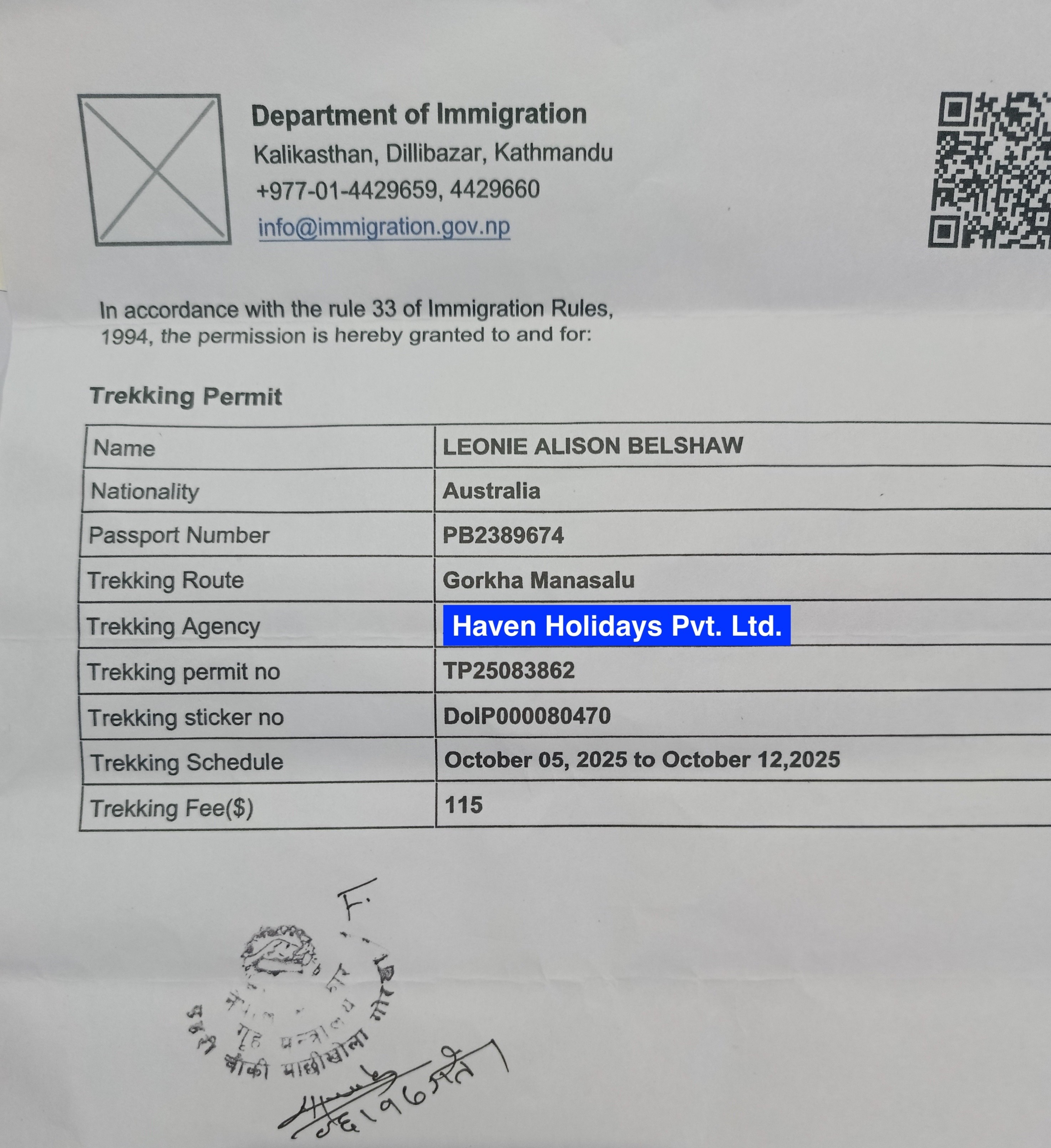
Start with permits—don’t leave this to the last minute. You’ll need the Manaslu Restricted Area Permit (MRAP), which runs $100 for the first week in autumn, plus $15 for each extra day. The rest of the year, it drops to $75 plus $10 per extra day. These fees go toward conservation, so you know your money’s helping out.
Essential Permits for Manaslu Circuit Trek and Costs:
Manaslu Restricted Area Permit (MRAP): $100 (Sept-Nov) or $75 (other months) for 7 days, extra fee for additional days; needed from Jagat (1340m) to Dharapani (1860m).
Manaslu Conservation Area Permit (MCAP): $30 flat; covers conservation areas.
Annapurna Conservation Area Permit (ACAP): $30 flat; for the last section of the trail.
Guide: $25-30/day (required).
Porter: $15-20/day
Here, you also need the Manaslu Conservation Area Permit (MCAP) for $30, and the Annapurna Conservation Area Permit (ACAP), also $30. Pick up all three in Kathmandu before you hit the trail.
Pick up a Manaslu Conservation Area Permit (MCAP) for $30. You’ll need the Annapurna Conservation Area Permit (ACAP) too, same price. These, plus the Manaslu Restricted Area Permit, are all handled in Kathmandu—guides usually sort the paperwork quickly. With these in hand, you’re good to go.
Solo trekking isn’t allowed in restricted areas. You need at least one other person, and a licensed guide is non-negotiable. Porters help lighten your load and make the walk a lot easier. These rules aren’t just red tape—they make the trek safer, especially when you’re miles from anywhere.
For the whole Manaslu trek, you’re looking at about $1000 to $1500 per person. That covers permits, transport, food, and places to sleep. Teahouse meals run $5 to $10. Guides charge $25 to $30 a day. Travel with a group to cut down on costs.
Getting ready means training for the altitude. Do cardio and strength workouts for a few weeks before your trip. Plan rest days in your trek to acclimate. Bring layers—weather’s unpredictable up there. Good fitness keeps altitude sickness at bay.
Pack sturdy boots and a proper sleeping bag. Water purifiers and a first-aid kit are musts. Sunscreen is essential. When you pass through villages, respect local customs. Being well-prepared sets you up for a smoother trek.
Don’t skip insurance. Get a policy that covers emergencies and high-altitude trekking. Check if you need to follow any COVID rules. Learn a few basic Nepali phrases—it helps. The more you prepare, the fewer problems you’ll run into.
Go easy on the environment. Stick to leave-no-trace habits, book with eco-friendly operators, and chip in to community funds when you can. That way, the trails stay beautiful for everyone who comes after you.
Total estimated Manaslu Circuit trek cost: $1000-1500 per person (includes food $5-10/meal, lodging $10-15/night, transport $50-100)
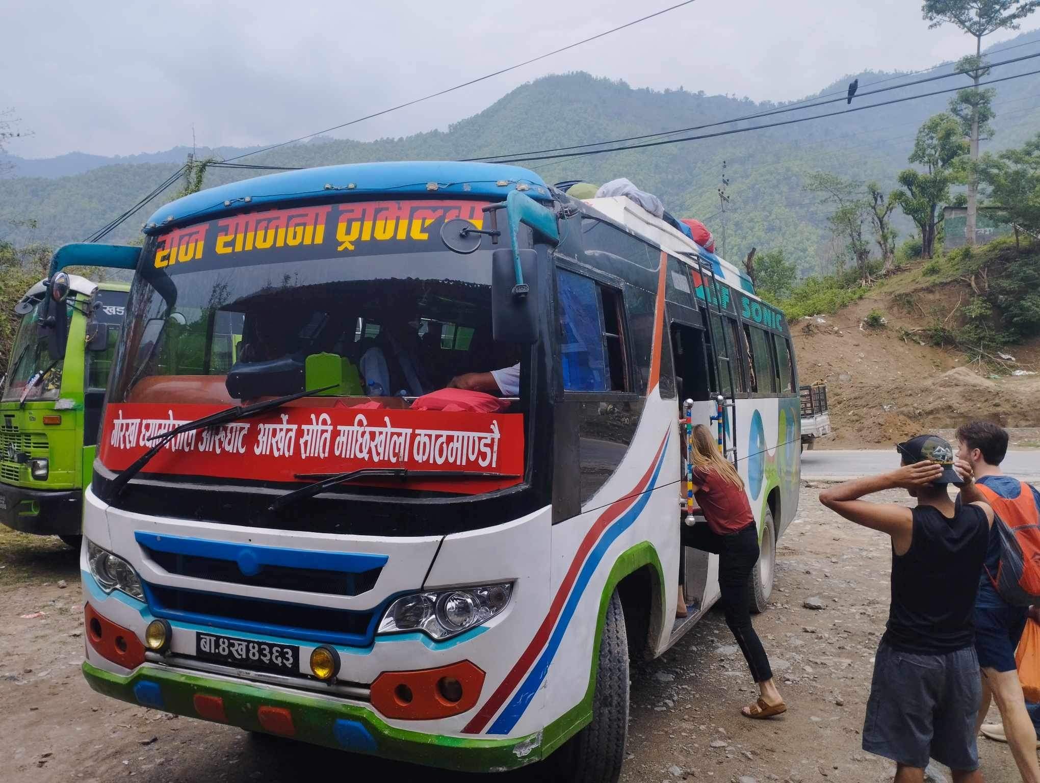
Kathmandu Departure to Dhading Besi: High Way Drive (Distance: ~80-85 km, Time: 4-6 hours, Elevation: ~650-1300 m)
Begin the Manaslu Circuit Trek experience by scenic highway drive from Kathmandu to Dhading Besi, spanning 80-85 km over 4-6 hours, featuring picturesque valleys and rolling hills.
"The journey begins- Bus traveling through mountain road near Machhakhola"
Introduction of Kathmandu to Dhading Besi: The journey commences at Kathmandu (1,400 meters) as travelers travel to Dhading Besi (650 meters). It symbolizes the opening of a paved highway. Additionally, it showcases initial scenic views of valleys. Despite this, it concludes the initial part of great excitement.
Kathmandu to Dhading Besi Drive: The event involves driving along the Prithvi Highway. The event observers experience drives over polygonal terraced fields and bending rivers. Additionally, the event participants get initial views of green rolling hillsides. Consequently, it facilitates great excitement.
Further, the drive occurs while crossing Naubise (1,000 meters) and Galchhi. The event includes driving buses over mild inclinations. Besides, the event spectators experience moderate merciless traffic. Therefore, it facilitates initial excitements of Highway drive.
Nonetheless, the drive allows stops at road side chat windows. The event experts experience trek related information. Further, the event spectators relax when the elevation decreases. Accordingly, it helps to show initial sensation.
Consequently, the drive resembles rural life in Nepal. The event participants witness farmers performing daily activities in paddy fields. Further, the event travelers witness Trisuli River (500 meters) running parallel to the highway. As a result, the event initiates with much vigor in the Highway drive.
In addition, the event's duration gets influenced by weather. The event gets delayed because of rainy weather. Despite this, the event witnesses Mountains during sunny weather. Therefore, it manages to induce sensation.
Moreover, the expense of shared Jeeps piles up to $10-15 per person. The expense of private vehicles culminates up to $100-150. Also, the expense of permits gets scrutinized beforehand. So, the expenditure linked with Kathmandu is manageable.
However, the highway winds through subtropical belts. The vegetation changes gradually. Also, the apparition of villages like Dharke is noted. Thus, the Manaslu Circuit Trek progresses culturally.
Despite this, the safety belts secure event group members. The event drivers narrowly control over bends. In addition, the event meanders by taking rests. So, the event maintains comfort levels.
Also, there is ample opportunity for photography. The event travelers capture very scenic hills. Further, the event traffic fields love while people blissfully wave. As a result, the event forms initial contact.
Furthermore, the event ends at Dhading Besi market. Shops provide food, toiletries. Also, teahouses provide foods. Therefore, trekkers get replenished before next stage.
However, the eminence of time varies from 1,400 meters to 650 meters. The bodies adapt slowly. Moreover, water consumption remains vital. Accordingly, the event emphasizes wellbeing of participants.
Nevertheless, the guides disclose the image of Ganesh Himal (7,422 meters). The peaks evoke unending sense of wonder. In addition, the stories invigorate each mile. So, the event creates learning.
In addition, the event witnesses the formation of group bonding. The event group members exchange conversations. Further, the event soothes with music. Hence, group friendship bonds.
Further, the highway remains in good condition. The potholes remain absent. Also, the signage remains clear. So, the event commences in a predictable way.
On the other hand, growing urban consciousness induces awareness. The rivers display pollution impacts. Further, the conservation becomes subject of discussion. Therefore, the event promotes understanding.
Although this, the arrival at Dhading Besi generates excitement. The event seems adventurous. Furthermore, the event aids rest. Accordingly, the Kathmandu is successfully finalized.
Dhading Besi to Arughat Bazaar: Moving onto Rural Roads (Distance:~50-55 km, Time: 3-4 hours, Elevation:~570-650 m)
Get adventurous about transition to rural roads from Dhading Besi to Arughat Bazaar on Manaslu Circuit Trek, 50-55 km for 3-4 hours, going through Budhi Gandaki corridor.
Yet, the arrival of Arughat rejuvenates. Discovery is upcoming. Simultaneously, arrangements complete. And that makes the conclusion to the move to country roads quite successful:
Segment
Distance (km) | Duration (hrs) | Key Features
Dhading Besi Start
0 | 0 | Market hub
Benighat Midway
20-25 | 1-2 | River views
Gola Bhanjyang Climb
30-35 | 2-3 | Hill ascents
Arughat Arrival
50-55 | 3-4 | Bazaar bustle
Drivers continuing the Manaslu Circuit Trek from Dhading Besi (~650 m) to Arughat Bazaar (~570 m). This portion comes with mixed surface. Moreover, it takes a step into river valleys. Lastly, it enhances engagement.
However, the journey sticks to the Budhi Gandaki River (~500 m). Vehicles cross the bridges from time to time. Moreover, the scene turns rugged. So, the transition to rural roads sparks excitement.
Apart from that, the roads get narrower after Dhading Besi. Dust flakes up on gravel routes. On top of that, villages such as Aarughat (~600 m) start appearing after passing through Salyantar. So, the Manaslu Circuit Trek gives an authentic taste.
However, people resume farming on the roadside. Trekkers experience livelihood. Furthermore, shops packed with fresh produce keep cropping up. So, the transition to rural roads invites interaction.
Apart from that, elevation remains close to 600 m. The atmosphere wears a warmer coat. Additionally, forests can be seen lining up the road. Therefore, the Budhi Gandaki corridor invites biodiversity.
On top of that, jeeps take on the bumpy track. Destined to keep hold of the seats, passengers get a firm grip. Nonetheless, the view makes up for discomfort. As a result, the Manaslu Circuit Trek fosters resilience.
Moreover, the costs pile up $5-10 for this section. Meanwhile, fuel prices fluctuate. Besides, drivers appreciate tips. So, the budget helps the journey go smoothly.
However, the commute goes past Gola Bhanjyang (~700 m) and Taribesi. You will also cross Netrawati River Bridge and ascend to Salyantar. Inclines test vehicles. Moreover, descents bring the fun, as well. So, the Budhi Gandaki corridor remains challenging.
Nevertheless, the safety measures must be appreciated. Helmets work well if necessary. Furthermore, keeping speed at low rates prevents accidents. Consequently, the Manaslu Circuit Trek rents up an adventure ride.
Besides that, cultural spots start emerging. Temples add up in the fields. Furthermore, prayers resonate. So, the transition to rural roads enhances spirituality.
Nevertheless, the Arughat Bazaar remains lively with marketplaces. Traders barter ready cash. Besides, lodges provide rest. Therefore, the Budhi Gandaki corridor draws activity.
On top of that, the elevation around Arughat remains 570 m. Acclimatization begins in a subtle manner. Moreover, restaurants recharge after a strenuous hike. So, the Manaslu Circuit Trek powers up.
In addition, groups discuss upcoming programs. Plans get clarified. On top of that, photography captures the memories. So, the transition to rural roads develops togetherness.
Later, the community roads gets upgraded on a seasonal basis. Upgrades remain undertaken to make sure transport facility stays available. Furthermore, alternative routes so do via Gorkha.
Arughat to Machhakhola – Rough ride to off-road trailhead (Distance: about 20–25 km, Duration: about 2–4 hours, Altitude: about 870–930 m at Machhakhola),
Important Road Difficulties:
To cope with bumpy jeep ride, pack bank for motion sickness. Additionally, bring water to stay hydrated on dusty jeep journey.
Imperative Packing Advice:
Furthermore, include rainfall protection gear for unpredictable showers. Consequently, comfort level increases on 2-4 hour jeep commute.
To validate this topic, here is an indicative list of details:
Dusty Jeep Track along the Banks of Budhi Gandaki River makes trekking otherworldly from Arughat (570 m) to Machhakhola (930 m).
Elevation appearance of 360 meters helps freshen up during initial acclimatization on this rough approach.
Shared jeep costs USD 5-10 enables journey accessibility in every financial class.
Magnificent waterfalls and settlements offer sociocultural insights before trek increases.
Experience the rough off-road trekking approach from Arughat to Machhakhola. The route covered about 20-25km. Jeep (bumpy track) along the Budhi Gandaki River marks the beginning of the Manaslu Circuit Trek in the remotest Himalayan trailhead of Nepal.
Actually, travelers ride from Arughat Bazaar (570 m) in robust jeeps. Travelers take dusty tracks beside the Budhi Gandaki River. This off-road trek approach increases anticipation for the Manaslu Circuit Trek. In addition, travelers have to overcome serpentine bends and rocky paths expertly.
Further, travelers pass through Soti Khola (710 m), a tiny river bank hamlet. Travelers notice waterfalls pounding into swimming pools and thick greenery. Besides, travelers are seen waving at terraced slopes beside the route. As a result, this segment introduces viewers to rural lifestyles in the Manaslu region.
Moreover, the altitude increases from 570 m to 930 m at Machhakhola. Vehicles cross bridges made of wood over furious flows. Hence, the ride prepares viewers for trek preparation. In fact, acclimatization occurs spontaneously during this off-road approach.
Similarly, warm weather ensures smoother commute on jeeps. Monsoons permit mudslides, lengthening hour of journey. This point guide request for 4WD jeeps for safety. Accordingly, travelers' planning enhances the Manaslu Circuit Trek odyssey.
Additionally, communal jeeps charge USD 5-10 in accordance with one’s resources per person. Personal hire enables every group to spend between USD 50-70. Sharing cost improvises trek costs. Travelers budget facilitate the Manaslu Circuit Trek odyssey.
Additionally, officials might spot wildlife such as monkeys. Travelers take images of glimpses of Ganesh Himal (7,422 m). Furthermore, this ride provides early scenic lives. Eventually, it links urban arrivals to Himalayan expeditions.
Finally, travelers wait at Machhakhola (930 m) for teahouse checking-in. Porters arrange supplies before trek commences. It signifies the beginning of the official Manaslu Circuit Trek.
Major Access: Kathmandu through Gorkha Bazaar to Arughat/Machhakhola (Longer Path)
Discover the scenic longer way to trailhead of Manaslu Circuit Trek via Gorkha Bazaar to Arughat and Machhakhola for the Manaslu Circuit Trek. It involves driving more than 200 km through temples and hills, suitable for history buffs craving a scenic and cultural route other than Dhading Besi.
Ultimately, the longer option will relax trekkers arriving at Machhakhola (930 m). Natural guide explanations sheds light on essential permits like MCAP (USD 30). Indeed, this approach provides a fitted beginning:
Aspect
Via Gorkha Bazaar
Via Dhading Besi
Total Distance
200+(km)
135-140(km)
Duration (hours)
8-10
7-8
Key Elevations
Kathmandu (1,324 m), Gorkha (1,100 m), Arughat (570 m).
Kathmandu (1,324 m), Dhading Besi (650 m), Arughat (570 m).
Highlights
Historic Gorkha Palace, scenic detours
Direct rural roads, faster access
Cost (USD per person)
25-40 shared
20-30 shared
Here, hikers and trekkers choose for the longer routes via Kathmandu (1,324 m) to Gorkha Bazaar (1,100 m). They proceed along the Prithvi Highway to Abu Khaireni (550 m) first. The long detour adds historical relevance to the Manaslu Circuit Trek. Additionally, drivers take breaks at roadside viewpoints to click photos.
Therefore, this Manaslu Circuit Trek route climbs to Gorkha Bazaar (1,100 m), where trekkers view Gorkha Palace. Furthermore, they examine ancient fortresses and temples in short spurts. Consequently, and local marketplaces, with snacks like sel roti, make the trip more complete.
Eventually, the trail drops to Arughat Bazaar (570 m), a 167 km journey. Conversely, it is more distant than Dhading Besi's 135 km route. Therefore, additional periods make the journey more cultural-centric in the Manaslu region.
Of course, it takes around 8-10 hours, compared to Dhading's 7-8 hours. The highways employ asphalt, some gravel, and off-road tracks. Hence, jeeps cope better than buses. As a result, minutes depend on transport medium between comfort levels and route time.
In effect, shared jeep rides cost USD 10-15, while a jeep from Gorkha to Arughat and Machhakhola costs USD 10-20. Consequently, the expense total reaches USD 25-40, higher than cheaper direct routes, though scenic advantages derive more value.
After that, elevation drops from 1,324 m in Kathmandu to 1,100 m in Gorkha. It plummets further to 570 m in Arughat before climbing again. In essence, the drive acts as a practice run for altitudes to follow while leading to Machhakhola (930 m).
Trek Kickoff: Machhakhola to Khorlabesi / Tatopani- (~12-14 km in total 5-7 hours, 870 m to ~990 m)
Starting the Manaslu Circuit Trek at Machhakhola to Khorlabesi and Tatopani, trekkers trek 12-14km along Riverside on cool trail crossing rivers and relaxing in hot springs, great Nepal Himalayan adventure option.
Here is a list of excursions of the day 7 from Machhakhola to Tatopani:
Scenic gorges along Riverside of Budhi Gandaki River on the Manaslu Circuit Trek kickoff.
Gentle elevation caused by ascends from 870 m at Machhakhola to 990 m at Tatopani.
Regaining energy through hot springs after walking for about 5-7 hours.
Local and traditional culture explored at small Khorlabesi village at 970 m.
Actually, initial Manaslu trek begins at Machhakhola(870 m). Trekker then treks on the narrow trail along the banks of the tributary of Budhi Gandaki River. This section offers alluring gorge view. In addition, porters skillfully carry equipment and supplies.
Then, onward trek ascends to Khorlabesi, a Gurung village (970 m). Trekker then crosses bamboo bridge over water stream. Also, villagers serve you fresh tea at roadside stall. This cultural interaction is enriching.
Gradually, ascents by the elevation to reach 990 m at Tatopani. Here, trekkers interact with hot springs to relax aching limbs. So, exhausted trekkers feel rejuvenated. Therefore, energy levels surmount for upcoming treks.
Moreover, guides advice rehydration due to humid environment. They also identify several exotic birds in flora and fauna. This section has everything for nature enthusiasts. So, the Manaslu Circuit Trek kickoff is engrossing.
Apart from this, most of the daily eating costs UDS 5-8 at teahouses. Also, permits like ACAP (USD 30) cost something in this route. Carrying timely permit saves from fines. So, a budget trip can proceed as planned.
Next, riverside sections are lined with cascading waterfalls. Trekkers then mount and descend minor slopes with care. So, trekking efficient using trekking poles for safety. With this, the trek is hassle free.
Finally, reaching at Tatopani a large gathering around campfire shares their trekking tales. This day consolidates the existing team in the Manaslu region.
Benefits of Hot Springs
In order to utilize hot springs melting tissues, sit for 20-30 minutes. Moreover, hot springs minutely regulate blood discharge.
Packing Tools
Also, bring quick-dry towels to use in hot springs. As a result, baggage and trekking comfort will be enhanced.
Going up the Gorge: Tatopani to Dobhan to Jagat (Taking the Hourglass Shape below 13-15 km. Duration: 5-7 hrs. Altitude: 990 m to 1,340-1,410 m)
Ascend the magnificent Budhi Gandaki gorge hiking on Manaslu Circuit Trek from Tatopani to Dobhan and Jagat, as you get into the restricted region with stone staircases and typical gorges. It's truly a Nepal Himalayas climb:
Stage
Distance (km)
Elevation Gain (m) | Key Features
Tatopani to Dobhan
6-7(Km)
+80 | Restricted area entry, stone steps, river crossings.
Dobhan to Jagat
7-8(Km)
+340 | Traditional villages, forested paths, permit checks.
Overall Ascent
13-15(Km)
+420 | Budhi Gandaki gorge views, cultural immersion.
Around 990 meters (3,250 ft), trekkers leave Tatopani and walk into the restricted area of the Manaslu zone. They ascend truly steep stone staircases and walk through extremely narrow gorges. It's a demanding part of the trek. Apart from that, checkpoint officials verify trekking permits when you enter into restricted zones.
Next, the trail route leads to Dobhan (about 1,070 meters or 3,510 feet), which is a quaint village by the riverbank. Trekkers relax in basic teahouses. Adding to that, mule caravans keep frequent on rutted pathways and. So, walking beware of rear-ended mule carts in narrow passages.
Similarly, elevation goes upwards to Jagat (about 1,410 meters or 4,630 feet) passing through woody sloped trails and reaching traditional whole slate-roofed villages. So, photographers thrill at the sight of architects' masterpieces. So, rich cultural inheritance enlightens the Manaslu trek routine.
Meanwhile, guides from Haven Holidays Pvt. Ltd. remain alert against altitude illnesses' forewarnings. They suggest slow-speed walking routines. Thus, health retains well to finish this climb of the gorge. So, equipping oneself with preparation-enhanced ones gives joy of constraint zones.
In addition, habitation at teahouses costs about 10-15 USD a night, and foods about 6-10 USD daily, so cash has relevance in remote areas. All these expenses assist local communities successfully.
In addition, stepped pathways compel trekkers to carry handy hand-rails and to take frequent 30-minute shelters. Therefore, prayer flags at vantage points lift spirits. Consequently, cordial matters in the Budhi Gandaki gorge motivate hiking adventure.
Finally, the adventure trekking to Jagat (1,410 meters or 4,630 ft) incorporates sightseeing within its village premises and communal dinners. Certainly, this is a big step in the Himalayan quest.
Ascending along the staircases
At this phase, trekkers should make use of hiking poles and take full 30-minute rests.
Village culture
Furthermore, trek towards Dobhan involves mixing with villagers and searching within them. Then, tourists benefit numerous.
Gurung Villages & Suspension Bridges: Jagat to Philim (Approximate Distance: 8-10 km, Estimated Duration: 3-5 hours, Altitude: 1410 m to 1570 m)
Experience Gurung culture through Annapurna Circuit Trek from Jagat to Philim, crossing suspension bridges and mani walls, 8-10km trek immersed in local life in Nepal's Himalayan valleys.
Things to remember
Acquire the basic Gurung language skills. Respect mani walls by circumambulation.
Precautions for bridge safety
Cross suspension bridges one person at a time. Assist bag straps while crossing for better stability.
Here is a list of activities during the segment:
Traditional Gurung communities in Philim (1570 m) thrive on the Manaslu Circuit Trek.
Crossing suspension bridges provide trepidation while crossing over the Budhi Gandaki River along the trail from Jagat (1,410 m).
Spinning prayer wheels aided by mani walls encourage spiritual connection while walking through scenic forests.
Here, trek from Jagat (1,410 m) suspension bridges. Discover Gurung stone houses. Understanding the culture through this trek in the Himalayan valleys of Nepal. Also, locals welcome trekkers to their villages.
Further, the Trek starts as trekkers leave Jagat (1,410 m), crossing suspension bridges. They encounter traditional Gurung villages with stone houses. This part emphasizes on sharing the local culture during the trek along the Manaslu Circuit Trek. Also, members of local community welcome travelers so welcoming atmosphere creates a bonding experience.
Onward, spiraled prayer wheels adorn mani walls. Trekkers spin wheels for harmony. Also, Millet and corn fields frame the traditional homes. Thus, rural lifestyle comes alive during this walking tour.
Elevation rises softly to 1570 m at Philim. Crossing bridges over the Budhi Gandaki River. With each crossing, adrenaline levels run high so safety harnesses are provided for crossing safely.
During the walk, guides discuss festivals held in the area. Trekkers enjoy baked chang beer. Thus, interactions build bonds with traditional communities. Therefore, cultural encounter benefits the tour.
Meanwhile, cheap places to eat in villages USD 4-6. Handicraft made by villages such as wove baskets on sale for USD 510. Supporting local economy makes trek memorable. So, spend wisely to make experience memorable.
Moreover, wild rhododendrons bloom in forests in spring. Animal sounds resound around suspension bridges. In conclusion, the segment mixes nature with thriving communities. So, photography is prolific.
Finally, arriving at Philim (1,570 m) provides sprawling views. Groups relax in village lodges overlooking breathtaking valleys. In the end, this stage encapsulates the spirit of Gurung culture.
Upper Valley Entry: Philim to Deng via Ekle Bhatti (Distance: ~18-20 km, Duration: 6-8 hours, Elevation: 1,570 m to 1,860 m)
Meanwhile, take upper Budhi Gandaki valley into the Manaslu Circuit Trek from Philim to Deng via Ekle Bhatti 18-20km of forest trekking, threading scattered hamlets for distant Himalayan sensations in Nepal.
Manaslu Circuit Trek Daily Distances and Elevations:
Stage
Distance (km)
Elevation Gain (m) | Key Features
Philim to Ekle Bhatti
6-7
+30 | Forested paths, teahouse rests, initial upper valley entry.
+290 | Dense forests, waterfalls, cultural glimpses in Manaslu Circuit Trek.
Here, guides and porters take trekkers from Philim (1,570 m), entering thick forests. They cross Ekle Bhatti (1,600 m), where small clusters of teahouses tempt visitors. This longer day begins the entry to upper valleys in the Manaslu Circuit Trek. Moreover, trails crisscross through pine forests steadily.
Immersed in dense woods, hikers see isolated hamlets. They observe yaks grazing lawns and as they listen to waterfalls crashing from cliffs. Additionally, the richness of scenic marvels propels trekkers onwards.
Moreover, their walking pace rises to Deng (1,860 m) along gentle ascents and may enjoy open valleys. Forests fall back behind them, revealing vistas of Shringi Himal (7,187 m). Consequently, trekkers set off more enthusiastic.
Likewise, guides call out instructions about medicinal herbs as trekkers seek refuge in Ekle Bhatti teahouse for camel juice and snacks. As a result, rest and energy restoration remains uninterrupted. Consequently, there is momentum in the Manaslu Circuit Trek through forests.
Meanwhile, costs for full day meals on Manaslu Circuit Trek in walk-in lodges range from USD15-20 and water refills costs USD1-2 per bottle. Therefore, navigating water appropriately prevents precipitated ailments. As a whole, the terrain remains affordable in secluded zone.
In addition, mule traces along crowded narrow routes, and trekkers step aside to avoid delays. Hence, adherence prevents disputes. Subsequently, yak herders and other local people interact with trekkers.
Finally, reaching Deng (1,860 m) comprises mountain lodge stays and communal fires ward off shivers. Without a doubt, this stage joins trekking tour to the upper Himalayan heights.
Wildlife Mobility Tips
Join traveling pooch or pay for dedicated rider. Use trekker-friendly protective goggles to see clearly.
Local Employment Gleanings
Mix with local folk at Deng. Accordingly, discover about herds of yak transports.
Tibetan-Influenced Zone: Deng to Namrung(1,860m to 2,630-2,660m)(Distance: 19-20km; Duration: 6-8 hours)
Start of gradual ascent in Tibetan-influenced zone between Deng and Namrung enjoying dramatic vegetation transition from bamboo to pine providing cultural shift and Himalayan acclimatization experience in Nepal.
Gradual Climb Modes,
To reduce effects of altitude, drink sufficient water. Plus, carry fuel-based energy bars.
Insights into Forest-Shifts,
Simultaneously, monitor movement of plant-forms in transition to understand ecological changes.
Beginning trekkers leave Deng (1,860 m) pushing in Tibetan-influenced zone, walking gradual ascents amid bamboo-growth. This part incorporates new sights of Buddhist chortens and prayer flags along with villagers' indigenous chuba-dresses.
Likewise, pine-forests take over at higher altitudes in following stages. Hikers observe mani stones decorated with mantras along the path. Higher elevation profile helps in Himalayan acclimatization effort in the zone. Therefore, gentle pacing prevents unnatural fatigue during this part of Manaslu Circuit Trek.
Moreover, Rhododendron hedges replace bamboo groves while log bridges cross streams in another section. As a result, Himalayan indigenous fauna like langurs of the dog family come out in forests. Thus, this zone of Manaslu Trek presents great biodiversity encounters.
Besides, Tibetan Buddhism-like influence accompanies guides' explanation. Small gompas appear in villages for visitors. Owing to these advances, cultural immersion intensifies in Namrung (2,660 m). Hence, encounters are peaceful in this zone during the trek.
Meanwhile, room-charge in teahouses runs between USD 10 and 15 in the zone, while site-specific cuisines like thukpa cost approximately USD 5-7 each. Thus, budgetary provisions support this fairly long day in terms of expense. Overall, cost-structure remains reasonable in whole of this uninhibited zones.
Same goes for the air in ascending passages filled with fresh pine scents.
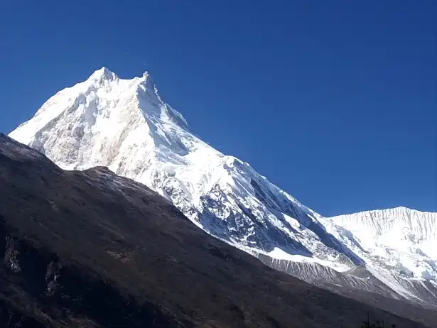
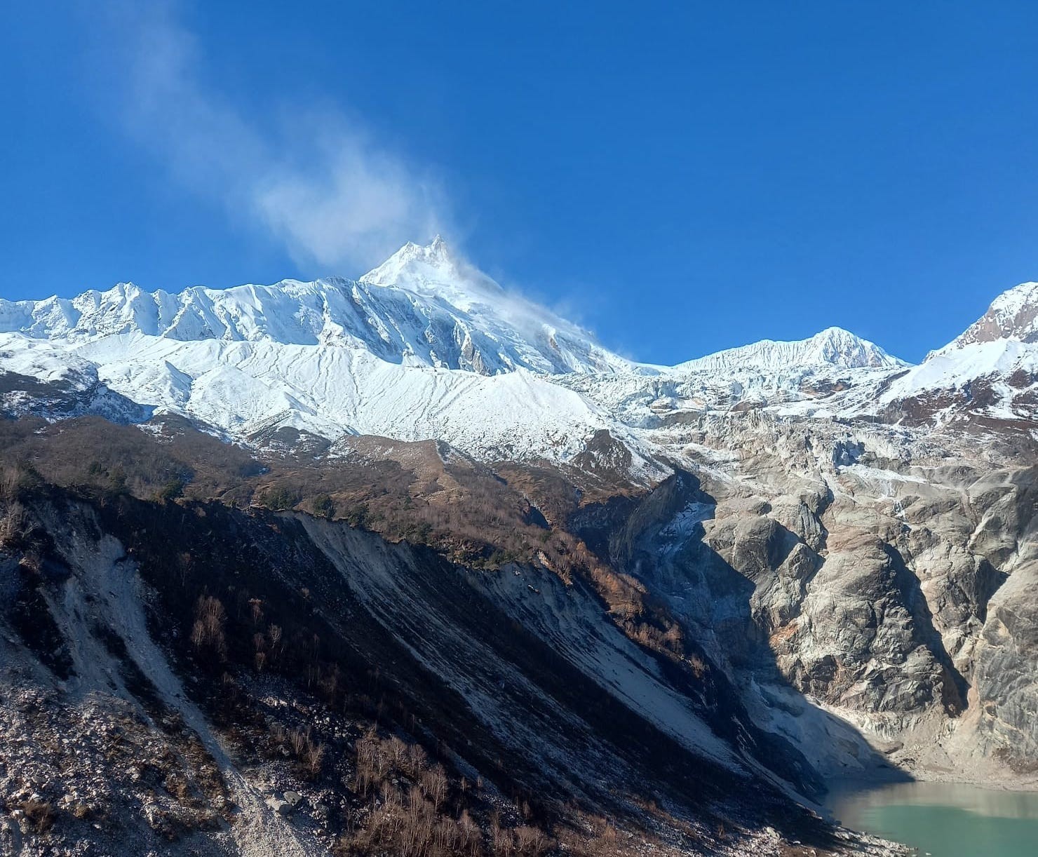
Views need teasing of ascending hikers revealing Manaslu (8,163 m) ahead.
Motivate camps new heights through transitions. Food stalls of rest stops rejuvenate wild ambitions.
Finally, arriving at Namrung (2,660 m), hikers see traditional Tibetan gates leading into village. Groups relax in yak butter tea accommodations. This zone defines significant cultural influence of Tibetan Buddhists in the trek.
To maintain topic's support, here is a bullet list of trekkers' items:
Gradual ascend in Tibet-influenced zone from Deng (1,860 m) to Namrung (2,660 m) avails Himalaya-Acclimatization journey during Manaslu Circuit Trek. Bamboo-forests gradually replace with pine-beds clarifying varied Himalayan plants towards the latterday.
Buddhist cultural symbols increase steadily in this zone along with elevation. Mani-stones carved with prayers decorate the zone.
An ascent of 800 meters promotes emergencies of altitude symptoms, which have to be monitored properly.
First Clear Manaslu Views Namrung to Lho / Shyala (Distance: ~10-12 km, Duration: 4-6 hours, Elevation: 2,630 m to 3,180-3,500 m)
Experience the first clear Manaslu views on the Manaslu Circuit Trek from Namrung to Lho and Shyala, a 10-12km walk with breathtaking panoramas of Manaslu and nearby peaks for memorable Nepal Himalayan vistas.
Location
Elevation (m)
Key Panoramas | Duration Impact
Namrung to Lho
2,630-3,180
First Manaslu views, Ribung Gompa | 2-3 hours, gentle ascents.
Lho to Shyala
3,180-3,500
Surrounding peaks like Himalchuli | 2-3 hours, ridge walks.
Here, travelers begin at Namrung (2,630 m) chasing first Manaslu views. They climb over open meadows. The shorter day reveals incredible vistas steadily. On top of that, prayer flags wave at vantage points.
Then, the way reaches Lho (3,180 m) with Ribung Gompa. Trekkers observed Manaslu Peak (8,163 m). In addition, surrounding mountains such as Himalchuli (7,893 m) fill skies. So, photo stops happen more frequently in this section.
Moreover, elevation increases to Shyala (3,500 m) through gentle ridges. Stunning views are the reward. As a result, inspiration peaks amid Himalayan giants. Therefore, the Manaslu Circuit Trek highlights become clearer.
What's more, guides describe the peaks' histories. Villages provide apple orchards for snacks. Consequently, local flavors match well with the amazing views. Hence, sensory adventures intensify the trek.
Additionally, lodge accommodations on Manaslu circuit trek in Lho cost USD 12-18. Vegetarian dishes cost USD 6-8. So, cash readiness guarantees relaxation. Overall, costs align with scenic rewards.
On top of that, wildflowers add color in season along routes. Hikers encounter eagles over their heads. As a result, nature's theater complements Manaslu landscapes. Later, acclimatization days involve easier hikes.
Once in Shyala (3,500 m), travelers enjoy 360 degree village sunsets. Groups ponder the amazing vistas.Indeed, a visit to this stage enthralls with Himalayan beauty.
Panorama Photography Tips
To take the most stunning shots, bring wide-angle lenses. Also, find opportunity during golden hours.
Peak Identification Guide
Furthermore, identify each Manaslu clearly. Doing so leads to enrich understanding.
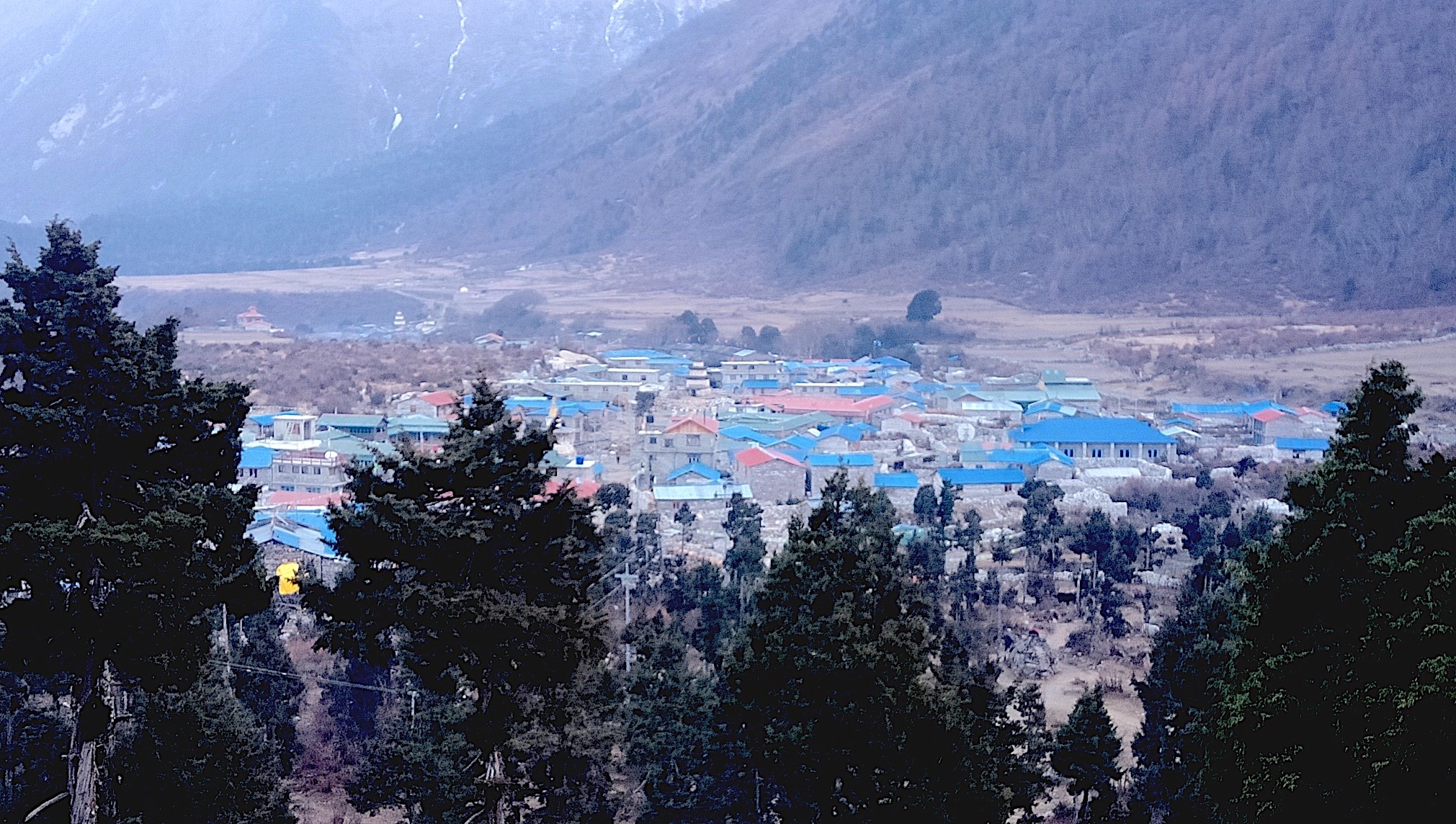
Heart of the Circuit: Lho to Samagaon (Distance: ~8-10 km, Duration: 3-5 hours, Elevation: 3,180 m to 3,520-3,530 m)
Here, trek to the cultural and adrenaline High in the Himalayas of Nepal. The trek covers 8-10km from Lho (3,180 m) to Samagaon (3,530 m) through Tibetan-style villages and monasteries with a dramatic backdrop of the Himalayan wilderness.
Monastery Approximations:
Furthermore, make it a point to remove footwear. Consequently, social approval increases. To illustrate the matter, here is a flash bulleted list of notable highlights.
Examining monastery offers insight and enlightens trekkers on the Buddhist culture of Samagaon (3,530 m).
The journey from Lho (3,180 m) extends along 3-5 hours, passing Ribung Gompa and other monasteries against views of Manaslu Peak (8,163 m).
A steady increase in elevation to 3,530 m, passing through Mani walls and seeing praying wheels.
The journey begins in Lho (3,180 m), immersing trekkers in the circuit's heart. They venture through picturesque Tibetan villages sprinkled with chortens and prayer wheels as they track-paths. Furthermore, they stumble upon historic monasteries perched in the terrain under the azure sky of Manaslu Circuit.
Next, it's guides' turn to lead groups past vibrant mani walls. They fraternize with villagers in traditional attire. Additionally, elevation climbs consistently until reaching Samagaon (3,530 m), revealing magnificent panoramic views of Manaslu Peak (8,163 m) atop the snow-covered cross-looking Himalayas in Tibetan culture. Ayrıca, Shrine-like monasteries and Ribung Gompa stimulate quiet meditation. They learn about sage-like Buddhist rituals in the sanctuary. Consequently, cultural ties deepen in the circuit's core.. Hence, manaslu trek journey intensifies spiritual Connect by monasteries.
In contrast, shorter rides offer photo breaks under the vast Himalayan sky. Porters' help lighten the toil along the relaxed course and conserve geyser's fuel for farther altitudes. Therefore, adventure levels top out while maintaining the holistic qualities of Tibetan monasteries. Besides, Samagaon's teahouse provides the USD 15-20 for lively stay. Local cuisines such as momos fetch USD 5-7 and enhances preparation for heightened heights. In the end, this affordability maintains the joyous journey to the monasteries.
Correspondingly, yaks traditionally feed in green pastures en routeto show how nature works side by side with pastures of Manaslu. Glistering Himalayan snow-Himalayan peaks motivate discerning trekkers to imagine the majestic feat. As a result, public approval becomes an obvious extra. Later, the natural tendency involves the gradual progression of acclimatization in this pathway. Finally, entry into Samagaon (3,530 m) exposes wide-ranging valleys. Participants compose commemorative narratives around fires, drinking games played out on their minds. True to that, the core of the circuit truly symbolizes the heart of Manaslu.
Village Help
To do so, give small presents to villagers and offer genuine reverence to monastery etiquette.
"Snow-covered Mount Manaslu overlooking Birendra Lake"
Acclimatization & Exploration Day: Samagaon Rest with Side Trips (Birendra Lake / Pungyen Gompa / Manaslu Base Camp View, Elevation: Up to ~4,000-4,800 m)
Enjoy an acclimatization day at Samagaon on Manaslu Circuit Trek, with side trips to Birendra Lake, Pungyen Gompa, and Manaslu Base Camp views for high-altitude adjustment and sightseeing in Nepal Himalayas.
Side Trip
Elevation (m)
Duration (hours) | Key Features
Birendra Lake
3,600
1-2 round trip | Serene glacial lake, easy walk for acclimatization day.
Pungyen Gompa
4,070
3-4 round trip | Ancient monastery, forested paths, spiritual exploration.
On this day, travelers use it for acclimatization in Samagaon (3,530 m). They take side trips for mild activity. It avoids altitude sickness effectively. Additionally, Birendra Lake (3,600 m) provides calm reflections in Manaslu Circuit Trek.
Following, trekkers go to Pungyen Gompa (4,070 m) for spiritual comfort. Trails move across moraines and forests. Furthermore, panoramas of glaciers spark the exploration. Hence, acclimatization day makes hearts strong through side trips.
In addition, Manaslu Base Camp view (4,800 m) satisfies with expansive sights. Hikers climb optional routes carefully. Consequently, oxygen levels get used to gradually. So, this exploration day withstood the Larke Pass in high-altitude adjustment.
At the same time, guides watch health during excursions. Consuming water matters. As a result, head pains fade away naturally. Therefore, the Manaslu Circuit Trek distresses from organized rest in acclimatization.
In contrast, side trip fees involve guide prices at USD 20-30. Nibbles cost USD 3-5 per head. Thus, preparations guarantee smooth pleasure. In general, investments produce safer journeys in exploration day.
What’s more, Birendra Lake shines azure under daylight. Pungyen Gompa resounds with prayers. Therefore, cultural strips come alive vibrantly. Next, Manaslu Base Camp sights motivate subsequent struggles.
Eventually, resuming to Samagaon (3,530 m) permits complete recuperation. Parties reflect upon features over supplementary meals. Truly, this acclimatization day empowers the trek with side trips.
Sama Gaun -A peaceful mountain stop
Health Care Tips
To ensure safety, check pulse oximeter readings. Also, rest if signs develop.
Side Trip Arrangements
Besides, wear layers suited for different heights. Also, comfort peaks.
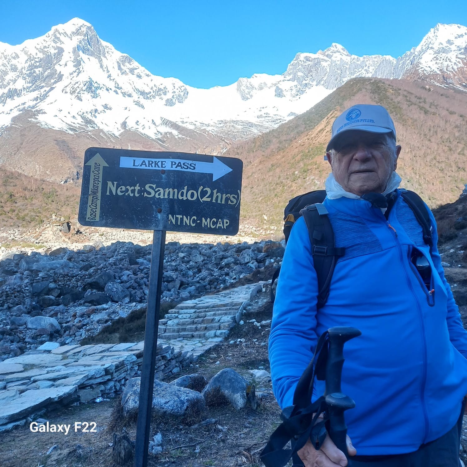
Borderlands & Windy Trails: Samagaon to Samdo (Distance: ~8-9 km, Duration: 3-4 hours, Elevation: 3,520 m to 3,860-3,875 m)
Explore borderlands and windy trails on the Manaslu Circuit Trek from Samagaon to Samdo, an 8-9km trek close to Tibet border along historical trade routes. Open-air yaks add majestic charm on these high-altitude Nepal paths, creating a cultural depth.
Trekker walking through alpine landscape toward Larke Pass
In conclusion, the following highlights can summarize the Manaslu Circuit trek Route:
Borderlands near Tibet border convey cultural lessons from Samagaon (3,520 m) to Samdo (3,875 m).
Windy trails traverse old trade routes, showcasing prayer flags and yak pastures in 3-4 hours.
Elevation climbs to 3,875 m.
Consequently, the group might sight Himalayan creatures like blue sheep.
Distances of 8-9 km stretch allow pleasant walk amidst history.
High pass challenge: Samdo to Dharmasala / Larke pass to Bimthang
Journey Distance: 20-22 km (roughly 1-2 days of trekking),
Time taken: 8-12 hrs, Highest Point: 5,106m (Larke pass)This challenge is taken on the Manaslu Circuit Trek from Samdo to Dharmasala and Larke Pass to Bimthang.
This is a trek of an epic distance of 20-22km with breathtaking views of the Himalayas and an adrenaline rushing stake of altitude in the rough terrain of Nepal.
Here, hikers leave Samagaon (3,520 m). They traverse borderlands routes. Hence, windy trails wind alongside historical trade routes. In fact, this section approaches Tibet border vividly. Still, yaks graze freely on expansive meadows.
Subsequently, elevation increases to Samdo (3,875 m) through steady ascents. Therefore, trekkers observe Tibetan refugee colonies. In addition, prayer flags flutter on powerful winds. As a result, borderlands cultural factors grow intense amid windy trails.
Likewise, the historical salt trade routes emerge. Trekkers traverse smaller streams cautiously. Therefore, Himalayan summits becomes a temptation. Overall, the Manaslu Circuit Trek involves high-altitude borderlands cultural explorations.
Alongside, guides point out Himalayan wildlife such as blue sheep. Windy trails require multiple layer clothing. In turn, hiking comfort maximizes on short ascents. As such, borderlands explorations foster higher elevation adjustments.
On the other hand, a night's stay in Samdo can cost USD 15-20. Food may add a further USD 6-8 per meal. In conclusion, monetary prearrangements can assist on historical trade route passages. Soon, trekkers get more Value for money.
Apart from this, mani walls mark trail tracks canonically. Consequently, borderlands connectivity becomes unmissable, evoking the allure of Tibet borderland tribes. In effect, windy trails cultivate nomadic histories. Then, acclimatization progresses through borderlands.
Last but not least, the arrival at Samdo (3,875 m) provides ample vantage points and rest facilities. Certainly, this moment captures the soul of the Manaslu Circuit Trek on the verge of Tibet border.
Navigation tips for windy trails,
Securely fasten hats.
Moreover, breathe frequently too.
Cultural tips for borderlands,
Respect strongly customs and traditions. This idea can yield excellent rewards.
Cautions while at high altitudes,
To focus on illnesses, drink plentifully. Meanwhile, ascend gradually throughout.
Photography Additions at heights,
Also, employ filters to minimize glares. Consequently, photographs scream drama.
Travelers depart from Samdo (3860 meters) en route to Dharmasala (4460 meters). They face steep routes during this high pass challenge. This section readies for Larke Pass. Moreover, stony terrains demand durable boots.
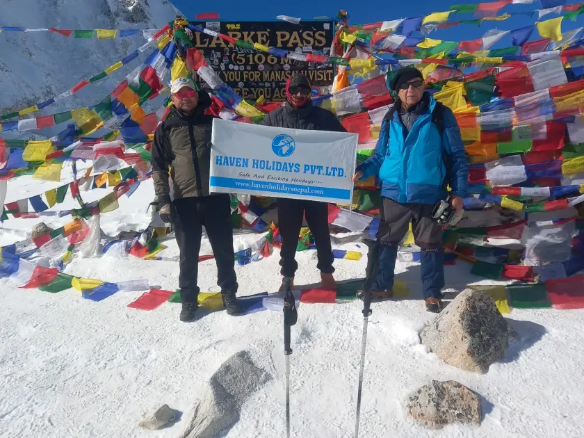
Secondly, from Dharmasala (4460 meters), trekkers ascend to Larke Pass (5,106 meters). Frozen terrains challenge limits amid Himalayan views. Additionally, prayer stones adorn the top. Hence, sense of achievement booms during high pass challenge.
Thirdly, descend to Bimthang (3590 meters) through glacier moraines. Himalayan majesties emerge in views of Himlung Himal (7126 meters). Thus, exhaustion wanes amid fantastic sights. Therefore, Manaslu Circuit Trek peaks at Larke Pass.
On top, guides check oxygen levels at heights. In high pass challenge, early morning starts are vital. Consequently, the sun rises on Himalayan plains. Therefore, safety dovetails with thrill of Larke La Pass.
Meanwhile, overnight costs in Dharmasala, ranged between USD 20-25. Contributions of packed lunches added around USD 5-7. In sum, financial matters cover high pass challenge requisites. Altogether, investments gratify with stunning Himalayan sights.
Furthermore, the wind sounds in ears at the summit of Larke Pass. Adventurers take snaps of Annapurna II (7937 meters). This High pass challenge leaves no stone unturned. Then, descend greets Bimthang (3590 meters) valleys.
Finally, arrive at Bimthang (3590 meters) amid sylvan solace. Parties applaud as they cross Larke Pass. This is the segment which characterizes Manaslu Circuit Trek with Himalayan sights.
Stage
Distance (km)
Elevation Change (m) | Key Features
Samdo to Dharmasala
6-7
+600 | Steep ascents, base camp prep for high pass challenge.
Dharmasala to Larkya La
8-9
+700 to 5,160 | Snowy trails, summit views in Larke Pass.
Larkya La to Bimthang
10-12
-1,570 | Glacier descents, Himalayan vistas of peaks like Himlung Himal.
Descent & Return: Bimthang to Dharapani, Drive to Besisahar & Kathmandu (Trek Distance: ~18-20 km to Dharapani, Time: 6-8 hours trek + 7-10 hours drive, Elevation: 3,720 m descend to ~1,900 m then to 760 m at Besisahar)
Join the last foot step of Manaslu Circuit Trek descended from Bimthang to Dharapani, with a brief join in Annapurna Circuit, and then a scenic drive to Besisahar and Kathmandu, to relax and reflect on final Himalayan stage.
Stage
Distance/Duration
Elevation Change (m) | Key Features
Bimthang to Dharapani
18-20 km / 6-8 hours
3,720 to 1,900 | Forested descent, Annapurna Circuit join, village passes.
Dharapani to Besisahar
~50 km / 2-3 hours
1,900 to 760 | Jeep tracks, Marsyangdi River views, recovery phase.
At Bimthang (3,720 m), trekkers descend along trail flanked by forest via Larke Pass (5,106 m). Subsequently, the trek route converges onto Annapurna Circuit temporarily. Furthermore, riverside track offers gentle glide off high altitude.
Then, elevation drops to Dharapani (1,900 m) over 18-20 km trek route. Meanwhile, en route summit villages of Tilije (2,300 m) and Goa (2,510 m). In addition, alpine forests and blowzy rhododendrons accentuate landscape. Additionally, the trek distance provides recuperation during 6-8 hours.
Soon, elevation drops to Dharapani (1,900 m) and group boards jeeps for Besisahar (760 m). The drive rides along bumpy trail along Marsyangdi River. Accordingly, Annapurna Circuit escalopes add up during the drive. Also, this journey concludes trek admirably.
Otherwise, jeep fare is USD 10-15 per person shared. Alternatively, private coaches cost at USD 20-25 for extra travel comforts. Therefore, this long trek distance costs 7-10 hours drive. Thus, Manaslu Circuit Trek concludes on budget with descent and return.
In the same way, elevation taper off from 3,720 m to 760 m helps de-acclimatization. Meanwhile, the trek path feeds opportunities in wildlife watching. Therefore, nature satisfies final trekking journey. Conclusively, this joining Annapurna Circuit allows contemplation on trek attainment.
In addition, refreshment shops provide local thali for USD 5-7 on the route. Moreover, trek guides discuss highlights of trek on the journey. Therefore, muster in company strengthens on the return trek. Afterward, heading Besisahar (760 m) marks the urban episode.
In the long run, 200 km drive to Kathmandu (1,324 m) follows Prithvi Highway. Transportation solutions traverse valleys and hills securely. So, this descent and return summarizes the treasure of Manaslu Circuit Trek.
FAQS: Manaslu Circuit Trek Route
1. What is the Manaslu Circuit Trek? The Manaslu Circuit Trek is a journey that takes you around Mount Manaslu (8,163 Meters. You'll see Himalayan views visit Gurung and Tibetan villages and explore old monasteries. This trek is in an area called the Manaslu Conservation Area and it’s not as crowded as other treks. 2. How long is the Manaslu Circuit Trek? The Manaslu Circuit Trek usually takes 12 to 16 days. This includes traveling from Kathmandu to Machhakhola and back from Dharapani or Besisahar. Most people do this trek in 14 or 15 days with rest days to get used to the altitude before crossing the Larke Pass, which is 5,106 meters high. 3. What is the maximum altitude on the Manaslu Circuit Trek? The highest point on the trek is Larke Pass, which's 5,106 meters. You'll also get to some viewpoints like Pungyen Gompa or Manaslu Base Camp, which are around 4,000 to 4,800 meters high. 4. Is the Manaslu Circuit Trek difficult? The Manaslu Circuit Trek can be tough. You'll be walking for 5 to 8 hours a day going up and down paths and dealing with high altitudes. You should be in shape have some trekking experience and make sure you get enough rest to avoid altitude sickness. 5. Can I do the Manaslu Circuit Trek as a solo traveler in 2026? Yes, you can do the Manaslu Circuit Trek by yourself in 2026. Nepal has changed its rules. Now you don't need to be, with another trekker. You still need to go with a licensed guide and book through a registered trekking agency. You can't trek alone without a guide. 6. Do I need a guide for the Manaslu Circuit Trek? Yes, you definitely need a guide for the Manaslu Circuit Trek. The Manaslu Circuit Trek requires a guide for the whole trip. Even if you are trekking alone you must go with a guide from a registered agency. This is for your safety. To follow the permit rules. 7. What permits are required for the Manaslu Circuit Trek? For the Manaslu Circuit Trek, you need to get three permits. You need the Manaslu Restricted Area Permit, the Manaslu Conservation Area Permit and the Annapurna Conservation Area Permit for the way. You have to get all these permits from a registered trekking agency. 8. What is the best time to trek the Manaslu Circuit? The best time to trek the Manaslu Circuit is in the Spring from March to May or in the Autumn from September to November. During these times you can see the mountains clearly the weather is stable and the temperature is comfortable. Autumn is usually the time to see clear skies. 9. How is the weather during the Manaslu Circuit Trek? The weather on the Manaslu Circuit Trek changes a lot as you go higher. The lower parts are warm and green. The higher parts, above 3,000 meters can be very cold especially at night. The Larke Pass, which is 5,106 meters high often has winds and freezing temperatures. So, you need to wear clothes in layers to stay warm. 10. How do I reach the starting point of the Manaslu Circuit Trek? The Manaslu Circuit Trek starts at Machhakhola. To get there you drive from Kathmandu to Dhading Besi, which takes around 4 to 6 hours. Then you drive to Arughat Bazaar. Finally, you take a rough jeep ride, to Machhakhola. The total time it takes to get to Machhakhola is around 8 to 12 hours depending on the condition of the roads. 11. What are the major highlights of the Manaslu Circuit Trek? The major highlights are the views of Manaslu mountain crossing the high Larke Pass at 5106 meters and visiting Tibetan-influenced villages like Samagaon and Samdo. You will also see monasteries, Birendra Lake and hot springs at Tatopani. The trek is also known for its Gurung culture along the Budhi Gandaki gorge. 12. Is acclimatization included in the Manaslu Circuit itinerary? Yes, most itineraries include a rest day in Samagaon to help you adjust to the altitudes. On this day you can take trips to Birendra Lake, Pungyen Gompa or the Manaslu Base Camp viewpoint. This helps your body get used to the altitude before you reach Larke Pass. 13. What is the cost of the Manaslu Circuit Trek? The cost of the trek package ranges from USD 950 to 1,500 per person. The price depends on the group size, how long the trek's what services are included. The package usually covers permits, a guide, accommodation, meals and transport. 14. What should I pack for the Manaslu Circuit Trek? You should pack items like a good down jacket, sturdy trekking boots, trekking poles, a warm sleeping bag, rain gear, water purification tablets, sunscreen, a hat, gloves and layers for temperature changes. We provide a packing list when you book the trek. 15. Is there any risk of altitude sickness on this trek? Yes, there is a risk of altitude sickness on the Manaslu Circuit Trek especially when you cross Larke Pass at 5106 meters. To minimize the risk we include rest days, in the itinerary. Our guide is trained to handle altitude-related issues. It is also crucial to stay hydrated and ascend slowly. 16. Can beginners join the Manaslu Circuit Trek? Beginners can join the trek if they are physically prepared and have a guide. It is helpful to have experience with high-altitude trekking because the trek is in an area and you go up to high altitudes. 17. What kind of accommodation is available on the Manaslu Circuit? You stay in nice teahouses and lodges on the route. The rooms are usually for two people and the bathrooms are shared. As you go up higher the facilities get simpler. 18. How many hours do I walk per day on the Manaslu Circuit Trek? You walk between 5 to 8 hours per day. It depends on the part of the trek. The hardest day is crossing Larke Pass 5106 m. That day you might walk 8-12 hours. 19. What happens after crossing Larke Pass 5106 m? After you cross Larke Pass 5106 m you go down to Bimthang. Then you keep going to Tilje and Dharapani. From Dharapani you take a drive to Besisahar. Then back to Kathmandu. That is the end of the Manaslu Circuit Trek. 20. Why should I choose Haven Holidays Nepal for the Manaslu Circuit Trek? Haven Holidays Nepal is a choice for the Manaslu Circuit Trek. We are a registered trekking agency with experience. We plan well-organized trips with professional guides. We take care of permits, logistics and other arrangements. We also make sure to follow tourism practices, on the Manaslu Circuit Trek.

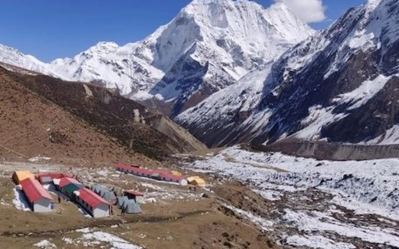
0.81855800 1738673284.webp)