[{"name":"Everest Base Camp Helicopter Tour","duration":"1","image_url":"https:\/\/www.havenholidaysnepal.com\/storage\/trip-galleries\/1\/thumb_6cd53005d75a86e373d31419d1b14d78.webp","offer_price":1195,"url":"https:\/\/www.havenholidaysnepal.com\/trips\/everest-base-camp-helicopter-tour"},{"name":"Everest Mountain Flight","duration":"1","image_url":"https:\/\/www.havenholidaysnepal.com\/storage\/trip-galleries\/4\/thumb_3b0b4f1d6f72b0ad224daf4752f2c6e0.jpg","offer_price":285,"url":"https:\/\/www.havenholidaysnepal.com\/trips\/everest-mountain-flight"},{"name":"Everest Short Trek","duration":"9","image_url":"https:\/\/www.havenholidaysnepal.com\/storage\/trip-galleries\/5\/thumb_BXPP3621.JPEG0.02033800 1727957098.webp","offer_price":895,"url":"https:\/\/www.havenholidaysnepal.com\/trips\/everest-short-trek"},{"name":"Gokyo Valley Trek","duration":"12","image_url":"https:\/\/www.havenholidaysnepal.com\/storage\/trip-galleries\/6\/thumb_10bc469b14731f23d3ce84a7092ad53f.jpg","offer_price":1195,"url":"https:\/\/www.havenholidaysnepal.com\/trips\/gokyo-valley-trek"},{"name":"15 days Annapurna Base Camp Trek","duration":"15","image_url":"https:\/\/www.havenholidaysnepal.com\/storage\/trip-galleries\/7\/thumb_87d1533bc45faf070990aef0579e4be4.jpg0.81855100 1728285496.webp","offer_price":785,"url":"https:\/\/www.havenholidaysnepal.com\/trips\/15-days-annapurna-base-camp-trek"},{"name":"Nepal Pilgrimage Tour","duration":"14","image_url":"https:\/\/www.havenholidaysnepal.com\/storage\/trip-galleries\/8\/thumb_02c3bcf2ad2e8a4c1703e90ae747b5f1.jpg","offer_price":1475,"url":"https:\/\/www.havenholidaysnepal.com\/trips\/nepal-pilgrimage-tour"},{"name":"UNESCO World Heritage Site Tour","duration":"10","image_url":"https:\/\/www.havenholidaysnepal.com\/storage\/trip-galleries\/9\/thumb_unesco-world-heritage-site-Lumbani-temple-buddhists-hindus-kathmandu-nepal0.36988600 17347617740.93089500 1737469667.webp","offer_price":715,"url":"https:\/\/www.havenholidaysnepal.com\/trips\/unesco-world-heritage-site-tour"},{"name":"Island Peak Climbing","duration":"16","image_url":"https:\/\/www.havenholidaysnepal.com\/storage\/trip-galleries\/11\/thumb_Island peak0.53947000 1734692503.webp","offer_price":2495,"url":"https:\/\/www.havenholidaysnepal.com\/trips\/island-peak-climbing"},{"name":"Upper Mustang Trek","duration":"18","image_url":"https:\/\/www.havenholidaysnepal.com\/storage\/trip-galleries\/12\/thumb_upper mustang 7 Oct-2024.jpg0.95398900 1728286166.webp","offer_price":2995,"url":"https:\/\/www.havenholidaysnepal.com\/trips\/upper-mustang-trek"},{"name":"Annapurna Circuit Trek","duration":"16","image_url":"https:\/\/www.havenholidaysnepal.com\/storage\/trip-galleries\/15\/thumb_tibetan-flags.jpg0.04843900 1728289138.webp","offer_price":985,"url":"https:\/\/www.havenholidaysnepal.com\/trips\/annapurna-circuit-trek"},{"name":"Gosainkunda Lake Trek","duration":"10","image_url":"https:\/\/www.havenholidaysnepal.com\/storage\/trip-galleries\/16\/thumb_5A8083B3-C007-41A8-853F-D0C37C97D235_1_105_c.jpeg0.52581200 1731845258.webp","offer_price":595,"url":"https:\/\/www.havenholidaysnepal.com\/trips\/gosainkunda-lake-trek"},{"name":"Zip-lining in Pokhara and Dhulikhel","duration":"1","image_url":"https:\/\/www.havenholidaysnepal.com\/storage\/trip-galleries\/18\/thumb_215f765e2ebc995dd5c800b4bfdbacc3.jpg","offer_price":82,"url":"https:\/\/www.havenholidaysnepal.com\/trips\/zip-lining-in-pokhara-and-dhulikhel"},{"name":"Annapurna Heli Tour","duration":"1","image_url":"https:\/\/www.havenholidaysnepal.com\/storage\/trip-galleries\/19\/thumb_d71a6bbb9fd4da8d1b567a5cdbdec85d.jpg","offer_price":555,"url":"https:\/\/www.havenholidaysnepal.com\/trips\/annapurna-heli-tour"},{"name":"Paragliding in Pokhara","duration":"1","image_url":"https:\/\/www.havenholidaysnepal.com\/storage\/trip-galleries\/20\/thumb_de788d2dd9726783431f882c007efae1.jpg","offer_price":65,"url":"https:\/\/www.havenholidaysnepal.com\/trips\/paragliding-in-pokhara"},{"name":"Ultra-Flight in Pokhara","duration":"1","image_url":"https:\/\/www.havenholidaysnepal.com\/storage\/trip-galleries\/21\/thumb_e27a9fb572a5c21611bb2a3c18e4b8f0.jpeg","offer_price":175,"url":"https:\/\/www.havenholidaysnepal.com\/trips\/ultra-flight-in-pokhara"},{"name":"Sarangkot Hiking","duration":"1","image_url":"https:\/\/www.havenholidaysnepal.com\/storage\/trip-galleries\/22\/thumb_100ef822fea19987166c6c1366215f15.jpg","offer_price":55,"url":"https:\/\/www.havenholidaysnepal.com\/trips\/sarangkot-hiking"},{"name":"Mera Peak Climbing","duration":"18","image_url":"https:\/\/www.havenholidaysnepal.com\/storage\/trip-galleries\/24\/thumb_d16ae3895f678cf26ffbf2455f541fb5.jpg0.31883400 1732617790.webp","offer_price":2475,"url":"https:\/\/www.havenholidaysnepal.com\/trips\/mera-peak-climbing"},{"name":"Lower Dolpo Trek","duration":"18","image_url":"https:\/\/www.havenholidaysnepal.com\/storage\/trip-galleries\/26\/thumb_Dolpo Galary - 1.JPG0.37725200 1727939952.webp","offer_price":2995,"url":"https:\/\/www.havenholidaysnepal.com\/trips\/lower-dolpo-trek"},{"name":"Nagarkot Sunrise\/Sunset Tour","duration":"1","image_url":"https:\/\/www.havenholidaysnepal.com\/storage\/trip-galleries\/27\/thumb_5147a5532644283a380f2e86f3857c13.jpg0.17748000 1728488108.webp","offer_price":30,"url":"https:\/\/www.havenholidaysnepal.com\/trips\/nagarkot-sunrise-sunset-tour"},{"name":"16 day Everest Base Camp Trek","duration":"16","image_url":"https:\/\/www.havenholidaysnepal.com\/storage\/trip-galleries\/28\/thumb_IMG_4311.JPG0.64984800 1727942213.webp","offer_price":1475,"url":"https:\/\/www.havenholidaysnepal.com\/trips\/16-day-everest-base-camp-trek"},{"name":"Ghorepani Poon Hill trek with Jungle Safari and Trishuli River Rafting -13 days","duration":"13","image_url":"https:\/\/www.havenholidaysnepal.com\/storage\/trip-galleries\/29\/thumb_Ghorepani Poon hill.jpg0.48460800 1728281439.webp","offer_price":795,"url":"https:\/\/www.havenholidaysnepal.com\/trips\/ghorepani-poon-hill-trek-with-jungle-safari-and-trishuli-river-rafting--13-days"},{"name":"Mardi Himal Trek","duration":"12","image_url":"https:\/\/www.havenholidaysnepal.com\/storage\/trip-galleries\/30\/thumb_s1.jpg0.62112600 1728200721.webp","offer_price":795,"url":"https:\/\/www.havenholidaysnepal.com\/trips\/mardi-himal-trek"},{"name":"Langtang Valley Trekking","duration":"10","image_url":"https:\/\/www.havenholidaysnepal.com\/storage\/trip-galleries\/31\/thumb_IMG_4702.JPG0.84916500 1727958504.webp","offer_price":685,"url":"https:\/\/www.havenholidaysnepal.com\/trips\/langtang-valley-trekking"},{"name":"Real Adventure Tour in Nepal","duration":"9","image_url":"https:\/\/www.havenholidaysnepal.com\/storage\/trip-galleries\/32\/thumb_ebd1b8cc78d90abe8b9003dd9a2f25bf.jpg0.82151300 1728213516.webp","offer_price":695,"url":"https:\/\/www.havenholidaysnepal.com\/trips\/real-adventure-tour-in-nepal"},{"name":"Luxury Tour in Nepal","duration":"10","image_url":"https:\/\/www.havenholidaysnepal.com\/storage\/trip-galleries\/33\/thumb_8574e61b252b18676b042caf30d830df.jpg","offer_price":1675,"url":"https:\/\/www.havenholidaysnepal.com\/trips\/luxury-tour-in-nepal"},{"name":"Luxury Everest Panorama Trek With EBC Heli Sightseeing","duration":"8","image_url":"https:\/\/www.havenholidaysnepal.com\/storage\/trip-galleries\/34\/thumb_URZL2397.JPEG0.01209600 1728027820.webp","offer_price":2575,"url":"https:\/\/www.havenholidaysnepal.com\/trips\/luxury-everest-panorama-trek-with-ebc-heli-sightseeing"},{"name":"13 day Everest Base Camp Trek with Helicopter","duration":"13","image_url":"https:\/\/www.havenholidaysnepal.com\/storage\/trip-galleries\/35\/thumb_IMG_4292.JPG0.70131500 1728029276.webp","offer_price":2095,"url":"https:\/\/www.havenholidaysnepal.com\/trips\/13-day-everest-base-camp-trek-with-helicopter"},{"name":"Manaslu Circuit Trek","duration":"16","image_url":"https:\/\/www.havenholidaysnepal.com\/storage\/trip-galleries\/36\/thumb_Mt Manaslu 03-Oct-2024.jpg0.65804900 1727938470.webp","offer_price":955,"url":"https:\/\/www.havenholidaysnepal.com\/trips\/manaslu-circuit-trek"},{"name":"Kanchenjunga Base Camp Trek","duration":"21","image_url":"https:\/\/www.havenholidaysnepal.com\/storage\/trip-galleries\/37\/thumb_Kanchanjunga Trek -!.jpg0.54744400 1727938497.webp","offer_price":2275,"url":"https:\/\/www.havenholidaysnepal.com\/trips\/kanchenjunga-base-camp-trek"},{"name":"Ganesh Himal and Sing-La Trek","duration":"18","image_url":"https:\/\/www.havenholidaysnepal.com\/storage\/trip-galleries\/38\/thumb_Ganesh Himal slider-1.jpg0.43764500 1727937722.webp","offer_price":2975,"url":"https:\/\/www.havenholidaysnepal.com\/trips\/ganesh-himal-and-sing-la-trek"},{"name":"Island Peak Climb with Everest Base Camp Trek","duration":"21","image_url":"https:\/\/www.havenholidaysnepal.com\/storage\/trip-galleries\/39\/thumb_2be428730fe83525bc85a010564f99de.jpg","offer_price":2750,"url":"https:\/\/www.havenholidaysnepal.com\/trips\/island-peak-climb-with-everest-base-camp-trek"},{"name":"Students' Adventure Tour in Nepal","duration":"12","image_url":"https:\/\/www.havenholidaysnepal.com\/storage\/trip-galleries\/41\/thumb_a926d22fbfe08cba271c41ac289b3fd2.jpg","offer_price":995,"url":"https:\/\/www.havenholidaysnepal.com\/trips\/students-adventure-tour-in-nepal"},{"name":"7 Day Poonhill Trek","duration":"7","image_url":"https:\/\/www.havenholidaysnepal.com\/storage\/trip-galleries\/42\/thumb_6196bd69036473293a2c24cc21ed57d7.jpg0.10880600 1728205378.webp","offer_price":555,"url":"https:\/\/www.havenholidaysnepal.com\/trips\/7-day-poonhill-trek"},{"name":"7 Days Annapurna Base Camp Trek","duration":"7","image_url":"https:\/\/www.havenholidaysnepal.com\/storage\/trip-galleries\/43\/thumb_IMG_2214.JPG0.08204900 1728202033.webp","offer_price":355,"url":"https:\/\/www.havenholidaysnepal.com\/trips\/7-days-annapurna-base-camp-trek"},{"name":"3 days Poonhill Trek","duration":"3","image_url":"https:\/\/www.havenholidaysnepal.com\/storage\/trip-galleries\/44\/thumb_Poon hill.jpg0.60816600 1731412954.webp","offer_price":165,"url":"https:\/\/www.havenholidaysnepal.com\/trips\/3-days-poonhill-trek"},{"name":"Poon Hill Luxury Trek with Chitwan-12 days","duration":"12","image_url":"https:\/\/www.havenholidaysnepal.com\/storage\/trip-galleries\/45\/thumb_Poom hill.jpg0.52074500 1730180532.webp","offer_price":1175,"url":"https:\/\/www.havenholidaysnepal.com\/trips\/poon-hill-luxury-trek-with-chitwan-12-days"},{"name":"Everest Luxury Trek-7 days","duration":"7","image_url":"https:\/\/www.havenholidaysnepal.com\/storage\/trip-galleries\/46\/thumb_ACRX9330.JPEG0.93236200 1728031275.webp","offer_price":2395,"url":"https:\/\/www.havenholidaysnepal.com\/trips\/everest-luxury-trek-7-days"},{"name":"Hindu Pilgrimage Tour in Nepal-10 days","duration":"10","image_url":"https:\/\/www.havenholidaysnepal.com\/storage\/trip-galleries\/47\/thumb_a94bf96a4d31decb419f6f828a3280d2.jpg","offer_price":995,"url":"https:\/\/www.havenholidaysnepal.com\/trips\/hindu-pilgrimage-tour-in-nepal-10-days"},{"name":"Everest Base Camp Short Trek-12 days","duration":"12","image_url":"https:\/\/www.havenholidaysnepal.com\/storage\/trip-galleries\/48\/thumb_IMG_4311.JPG0.52680100 1727945154.webp","offer_price":995,"url":"https:\/\/www.havenholidaysnepal.com\/trips\/everest-base-camp-short-trek-12-days"},{"name":"Everest Base Camp Hike 12 Days","duration":"12","image_url":"https:\/\/www.havenholidaysnepal.com\/storage\/trip-galleries\/49\/thumb_IMG_4260.JPG0.51729100 1728061234.webp","offer_price":1295,"url":"https:\/\/www.havenholidaysnepal.com\/trips\/everest-base-camp-hike-12-days"},{"name":"11 Days Everest Base Camp Trek","duration":"11","image_url":"https:\/\/www.havenholidaysnepal.com\/storage\/trip-galleries\/50\/thumb_IMG_4249.JPG0.21392500 1727946959.webp","offer_price":985,"url":"https:\/\/www.havenholidaysnepal.com\/trips\/11-days-everest-base-camp-trek"},{"name":"6 Days Annapurna Base Camp Trek","duration":"6","image_url":"https:\/\/www.havenholidaysnepal.com\/storage\/trip-galleries\/51\/thumb_6 days Abc.jpg0.58185400 1728200798.webp","offer_price":285,"url":"https:\/\/www.havenholidaysnepal.com\/trips\/6-days-annapurna-base-camp-trek"},{"name":"Annapurna Base Camp Trek","duration":"8","image_url":"https:\/\/www.havenholidaysnepal.com\/storage\/trip-galleries\/52\/thumb_IMG_2214.JPG0.29415700 1729487656.webp","offer_price":585,"url":"https:\/\/www.havenholidaysnepal.com\/trips\/annapurna-base-camp-trek"},{"name":"Everest Base Camp Trek with Helicopter Fly Out 10 Days","duration":"10","image_url":"https:\/\/www.havenholidaysnepal.com\/storage\/trip-galleries\/53\/thumb_IMG_4328.JPG0.52056600 1728058444.webp","offer_price":1875,"url":"https:\/\/www.havenholidaysnepal.com\/trips\/everest-base-camp-trek-with-helicopter-fly-out-10-days"},{"name":"Everest Base Camp Trek 14 Days","duration":"14","image_url":"https:\/\/www.havenholidaysnepal.com\/storage\/trip-galleries\/54\/thumb_Everest Base Camp Trek 14 days Oct 3 2024.JPG0.43202700 1727939745.webp","offer_price":1235,"url":"https:\/\/www.havenholidaysnepal.com\/trips\/everest-base-camp-trek-14-days"},{"name":"ABC Trek with Poonhill 11 Days","duration":"11","image_url":"https:\/\/www.havenholidaysnepal.com\/storage\/trip-galleries\/55\/thumb_ABC with fishtail.JPG0.21441100 1728277965.webp","offer_price":555,"url":"https:\/\/www.havenholidaysnepal.com\/trips\/abc-trek-with-poonhill-11-days"},{"name":"Muldai Hill Trek 9 Days","duration":"9","image_url":"https:\/\/www.havenholidaysnepal.com\/storage\/trip-galleries\/56\/thumb_7efee59f0a8c6817c8255bd2b9f3539d.jpeg0.19479300 1728213091.webp","offer_price":675,"url":"https:\/\/www.havenholidaysnepal.com\/trips\/muldai-hill-trek-9-days"},{"name":"Mardi Himal Trek 6 days","duration":"6","image_url":"https:\/\/www.havenholidaysnepal.com\/storage\/trip-galleries\/57\/thumb_slider 1.jpeg0.36909700 1728184981.webp","offer_price":590,"url":"https:\/\/www.havenholidaysnepal.com\/trips\/mardi-himal-trek-6-days"},{"name":"Mardi Himal Trek 7 days","duration":"7","image_url":"https:\/\/www.havenholidaysnepal.com\/storage\/trip-galleries\/58\/thumb_slider1.jpg0.61666600 1728206414.webp","offer_price":620,"url":"https:\/\/www.havenholidaysnepal.com\/trips\/mardi-himal-trek-7-days"},{"name":"Mardi Himal Trek 8 Days","duration":"8","image_url":"https:\/\/www.havenholidaysnepal.com\/storage\/trip-galleries\/59\/thumb_sli1.jpg0.38569100 1728206631.webp","offer_price":695,"url":"https:\/\/www.havenholidaysnepal.com\/trips\/mardi-himal-trek-8-days"},{"name":"14 Days Manaslu Trek","duration":"14","image_url":"https:\/\/www.havenholidaysnepal.com\/storage\/trip-galleries\/60\/thumb_sunrise-mt-manaslu-during-manaslu-circuit-larke-pass-trekking-himalaya-nepal (1)0.81855800 1738673284.webp","offer_price":885,"url":"https:\/\/www.havenholidaysnepal.com\/trips\/14-days-manaslu-trek"},{"name":"Dhampus-Sarangkot Trek with Chitwan 8 days","duration":"8","image_url":"https:\/\/www.havenholidaysnepal.com\/storage\/trip-galleries\/61\/thumb_Sarangkot Bhangyang.jpg0.75461400 1728210333.webp","offer_price":790,"url":"https:\/\/www.havenholidaysnepal.com\/trips\/dhampus-sarangkot-trek-with-chitwan-8-days"},{"name":"7 Days Golden Triangle Tour","duration":"7","image_url":"https:\/\/www.havenholidaysnepal.com\/storage\/trip-galleries\/62\/thumb_311ce1d117ee0ba75402a7c301bcdf830.73532400 1739179809.webp","offer_price":845,"url":"https:\/\/www.havenholidaysnepal.com\/trips\/7-days-golden-triangle-tour"},{"name":"Annapurna Circuit Trek 12 days","duration":"12","image_url":"https:\/\/www.havenholidaysnepal.com\/storage\/trip-galleries\/63\/thumb_IMG_20161024_092237.jpg0.57796600 1728289938.webp","offer_price":695,"url":"https:\/\/www.havenholidaysnepal.com\/trips\/annapurna-circuit-trek-12-days"},{"name":"Everest Base Camp Budget Trek 16 Days","duration":"16","image_url":"https:\/\/www.havenholidaysnepal.com\/storage\/trip-galleries\/64\/thumb_IMG_4423.JPG0.92579200 1728144669.webp","offer_price":958,"url":"https:\/\/www.havenholidaysnepal.com\/trips\/everest-base-camp-budget-trek-16-days"},{"name":"Poonhill Budget Trek 7 Days","duration":"7","image_url":"https:\/\/www.havenholidaysnepal.com\/storage\/trip-galleries\/65\/thumb_5be067852d0c5228d6f3155bc425c6b5.jpg","offer_price":395,"url":"https:\/\/www.havenholidaysnepal.com\/trips\/poonhill-budget-trek-7-days"},{"name":"Annapurna Base Camp Budget Trek 8 Days","duration":"8","image_url":"https:\/\/www.havenholidaysnepal.com\/storage\/trip-galleries\/66\/thumb_Pokhara.jpg0.16188000 1728212001.webp","offer_price":375,"url":"https:\/\/www.havenholidaysnepal.com\/trips\/annapurna-base-camp-budget-trek-8-days"},{"name":"The Real UNESCO Seven World Heritage Tour in Kathmandu 4 days","duration":"4","image_url":"https:\/\/www.havenholidaysnepal.com\/storage\/trip-galleries\/67\/thumb_Baudha Stupa.JPG0.63906900 1728201021.webp","offer_price":380,"url":"https:\/\/www.havenholidaysnepal.com\/trips\/the-real-unesco-seven-world-heritage-tour-in-kathmandu-4-days"},{"name":"Everest Base Camp Jeep Ride with Helicopter Return","duration":"14","image_url":"https:\/\/www.havenholidaysnepal.com\/storage\/trip-galleries\/68\/thumb_788ee5b63a6efb6f3c3d048b4270daca.JPG","offer_price":1895,"url":"https:\/\/www.havenholidaysnepal.com\/trips\/everest-base-camp-jeep-ride-with-helicopter-return"},{"name":"Annapurna Base Camp Jeep Ride with Helicopter Return 7 days","duration":"7","image_url":"https:\/\/www.havenholidaysnepal.com\/storage\/trip-galleries\/69\/thumb_abc jeep.jpg0.10280600 1728204064.webp","offer_price":1455,"url":"https:\/\/www.havenholidaysnepal.com\/trips\/annapurna-base-camp-jeep-ride-with-helicopter-return-7-days"},{"name":"Everest Base Camp Trek","duration":"15","image_url":"https:\/\/www.havenholidaysnepal.com\/storage\/trip-galleries\/70\/thumb_Everest Base Camp Trek 3 oct- 2024.JPG0.58445300 1727941472.webp","offer_price":1355,"url":"https:\/\/www.havenholidaysnepal.com\/trips\/everest-base-camp-trek"},{"name":"7 UNESCO World Heritage Tour Kathmandu 2 days","duration":"2","image_url":"https:\/\/www.havenholidaysnepal.com\/storage\/trip-galleries\/72\/thumb_Bhaktipur 3.jpg0.05559600 1728201496.webp","offer_price":150,"url":"https:\/\/www.havenholidaysnepal.com\/trips\/7-unesco-world-heritage-tour-kathmandu-2-days"},{"name":"Day Tour to UNESCO Heritage Sites","duration":"1","image_url":"https:\/\/www.havenholidaysnepal.com\/storage\/trip-galleries\/73\/thumb_228A1018.jpg0.79892500 1728199793.webp","offer_price":55,"url":"https:\/\/www.havenholidaysnepal.com\/trips\/day-tour-to-unesco-heritage-sites"},{"name":"Golden Triangle Tour in Nepal","duration":"8","image_url":"https:\/\/www.havenholidaysnepal.com\/storage\/trip-galleries\/74\/thumb_f54139cf9100f00015ffe0400687e946.webp","offer_price":588,"url":"https:\/\/www.havenholidaysnepal.com\/trips\/golden-triangle-tour-in-nepal"},{"name":"Everest Base Camp Honeymoon Tour by Helicopter with Pokhara","duration":"7 days","image_url":"https:\/\/www.havenholidaysnepal.com\/storage\/trip-galleries\/76\/thumb_RJTL7517.JPEG0.40261600 1731499989.webp","offer_price":9999,"url":"https:\/\/www.havenholidaysnepal.com\/trips\/everest-base-camp-honeymoon-tour-by-helicopter-with-pokhara"},{"name":"Yoga and Meditation Retreat Tour in Nepal","duration":"10 days","image_url":"https:\/\/www.havenholidaysnepal.com\/storage\/trip-galleries\/77\/thumb_decf8e33-6617-4400-9df0-63bf75509adf.JPG0.51948300 1731574810.webp","offer_price":2575,"url":"https:\/\/www.havenholidaysnepal.com\/trips\/yoga-and-meditation-retreat-tour-in-nepal"},{"name":"Chisapani-Nagarkot Trek","duration":"3","image_url":"https:\/\/www.havenholidaysnepal.com\/storage\/trip-galleries\/78\/thumb_0b64dfceaeab48ac36d685476bdebafb.webp","offer_price":165,"url":"https:\/\/www.havenholidaysnepal.com\/trips\/chisapani-nagarkot-trek"},{"name":"Chitwan Jungle Safari Tour","duration":"2","image_url":"https:\/\/www.havenholidaysnepal.com\/storage\/trip-galleries\/79\/thumb_IMG_1696.JPG0.28467800 1733054554.webp","offer_price":175,"url":"https:\/\/www.havenholidaysnepal.com\/trips\/chitwan-jungle-safari-tour"},{"name":"Kailash Overland Tour","duration":"16","image_url":"https:\/\/www.havenholidaysnepal.com\/storage\/trip-galleries\/80\/thumb_PA2605230.68496700 1735818657.webp","offer_price":2495,"url":"https:\/\/www.havenholidaysnepal.com\/trips\/kailash-overland-tour"},{"name":"4 nights 5 days Bhutan Tour","duration":"5","image_url":"https:\/\/www.havenholidaysnepal.com\/storage\/trip-galleries\/81\/thumb_PB0508470.23069500 1735828937.webp","offer_price":1265,"url":"https:\/\/www.havenholidaysnepal.com\/trips\/4-nights-5-days-bhutan-tour"},{"name":"Everest Base Camp Trek Without Flying","duration":"16","image_url":"https:\/\/www.havenholidaysnepal.com\/storage\/trip-galleries\/82\/thumb_308b054484eddc042e092e1ae2ae5586.webp","offer_price":685,"url":"https:\/\/www.havenholidaysnepal.com\/trips\/everest-base-camp-trek-without-flying"},{"name":"Everest Base Camp Trek by Land","duration":"16","image_url":"https:\/\/www.havenholidaysnepal.com\/storage\/trip-galleries\/83\/thumb_8f0f2784a3ae7343d193b64fe8d47c96.webp","offer_price":675,"url":"https:\/\/www.havenholidaysnepal.com\/trips\/everest-base-camp-trek-by-land"},{"name":"Everest Base Camp Trek by Jeep","duration":"16","image_url":"https:\/\/www.havenholidaysnepal.com\/storage\/trip-galleries\/84\/thumb_f82b3acdfc933bc3e0197624c001b0a6.webp","offer_price":675,"url":"https:\/\/www.havenholidaysnepal.com\/trips\/everest-base-camp-trek-by-jeep"},{"name":"Everest Base Camp Trek without Lukla Flight","duration":"16","image_url":"https:\/\/www.havenholidaysnepal.com\/storage\/trip-galleries\/85\/thumb_2d0acc76dc958e3122a3745074989914.webp","offer_price":675,"url":"https:\/\/www.havenholidaysnepal.com\/trips\/everest-base-camp-trek-without-lukla-flight"},{"name":"Langtang Valley Trek","duration":"7","image_url":"https:\/\/www.havenholidaysnepal.com\/storage\/trip-galleries\/86\/thumb_a845db06c5feada1478e8aed659fce97.webp","offer_price":199,"url":"https:\/\/www.havenholidaysnepal.com\/trips\/langtang-valley-trek"},{"name":"Everest Base Camp Trek with Gokyo Lake","duration":"17","image_url":"https:\/\/www.havenholidaysnepal.com\/storage\/trip-galleries\/87\/thumb_c6aa32f7654f2eda78134bc84ac70b79.webp","offer_price":1885,"url":"https:\/\/www.havenholidaysnepal.com\/trips\/everest-base-camp-trek-with-gokyo-lake"},{"name":"Everest Three Passes Trek","duration":"19","image_url":"https:\/\/www.havenholidaysnepal.com\/storage\/trip-galleries\/88\/thumb_db5364eaab56f5755da55868f8ca4258.webp","offer_price":1735,"url":"https:\/\/www.havenholidaysnepal.com\/trips\/everest-three-passes-trek"},{"name":"Annapurna Base Camp Trek From Pokhara","duration":"5","image_url":"https:\/\/www.havenholidaysnepal.com\/storage\/trip-galleries\/89\/thumb_49c813cf1054ff06108963924a78ee88.webp","offer_price":255,"url":"https:\/\/www.havenholidaysnepal.com\/trips\/annapurna-base-camp-trek-from-pokhara"},{"name":"Sarangkot Sunrise Tour from Pokhara","duration":"1","image_url":"https:\/\/www.havenholidaysnepal.com\/storage\/trip-galleries\/90\/thumb_932d995b8fb702634a23e8f9a0432c6e.webp","offer_price":35,"url":"https:\/\/www.havenholidaysnepal.com\/trips\/sarangkot-sunrise-tour-from-pokhara"},{"name":"Langtang Valley Trek-8 days","duration":"8","image_url":"https:\/\/www.havenholidaysnepal.com\/storage\/trip-galleries\/91\/thumb_81d3d0a6979c9ed01f65d5ade53820b2.webp","offer_price":250,"url":"https:\/\/www.havenholidaysnepal.com\/trips\/langtang-valley-trek-8-days"},{"name":"Manaslu Circuit Trek 12 days","duration":"12","image_url":"https:\/\/www.havenholidaysnepal.com\/storage\/trip-galleries\/92\/thumb_d8251bbef0c8a246a02bda5c150a27c2.webp","offer_price":675,"url":"https:\/\/www.havenholidaysnepal.com\/trips\/manaslu-circuit-trek-12-days"},{"name":"2 Days Poon Hill Trek","duration":"2","image_url":"https:\/\/www.havenholidaysnepal.com\/storage\/trip-galleries\/93\/thumb_9d8fa8f60767538857d6c7cb3a7fee8b.webp","offer_price":135,"url":"https:\/\/www.havenholidaysnepal.com\/trips\/2-days-poon-hill-trek"},{"name":"Upper Mustang Jeep Tour","duration":"6","image_url":"https:\/\/www.havenholidaysnepal.com\/storage\/trip-galleries\/94\/thumb_9a3098a6c860b87ad3339773ef5435b9.webp","offer_price":1095,"url":"https:\/\/www.havenholidaysnepal.com\/trips\/upper-mustang-jeep-tour"},{"name":"Tsum Valley Trek","duration":"11","image_url":"https:\/\/www.havenholidaysnepal.com\/storage\/trip-galleries\/95\/thumb_704a6a1eb293553827633dbd8ad7d22c.webp","offer_price":775,"url":"https:\/\/www.havenholidaysnepal.com\/trips\/tsum-valley-trek"},{"name":"Mardi Himal Trek from Pokhara","duration":"4","image_url":"https:\/\/www.havenholidaysnepal.com\/storage\/trip-galleries\/96\/thumb_c92e9ee49c2564a11c7a9ba593439efc.webp","offer_price":295,"url":"https:\/\/www.havenholidaysnepal.com\/trips\/mardi-himal-trek-from-pokhara"},{"name":"4 Days Poon Hill Trek","duration":"4","image_url":"https:\/\/www.havenholidaysnepal.com\/storage\/trip-galleries\/97\/thumb_c349e182edd0858f3e3409d945f0d2ec.webp","offer_price":215,"url":"https:\/\/www.havenholidaysnepal.com\/trips\/4-days-poon-hill-trek"},{"name":"Poon Hill Sunrise Jeep Tour from Pokhara","duration":"2","image_url":"https:\/\/www.havenholidaysnepal.com\/storage\/trip-galleries\/98\/thumb_509875052b16f6f9156db386e3592eb8.webp","offer_price":260,"url":"https:\/\/www.havenholidaysnepal.com\/trips\/poon-hill-sunrise-jeep-tour-from-pokhara"},{"name":"Muktinath Jeep Tour from Pokhara","duration":"3","image_url":"https:\/\/www.havenholidaysnepal.com\/storage\/trip-galleries\/99\/thumb_1651790cb7422703fe86d472a35d4f90.webp","offer_price":255,"url":"https:\/\/www.havenholidaysnepal.com\/trips\/muktinath-jeep-tour-from-pokhara"},{"name":"Ghorepani Poon Hill Trek from Pokhara","duration":"5","image_url":"https:\/\/www.havenholidaysnepal.com\/storage\/trip-galleries\/100\/thumb_27fa62452af4ea8e08544aaa035cc446.webp","offer_price":295,"url":"https:\/\/www.havenholidaysnepal.com\/trips\/ghorepani-poon-hill-trek-from-pokhara"},{"name":"Ghandruk, Poon Hill, Muktinath and Upper Mustang Tour","duration":"7 days","image_url":"https:\/\/www.havenholidaysnepal.com\/storage\/trip-galleries\/101\/thumb_a7dd15032cd9693005233b1df7dc63d3.webp","offer_price":685,"url":"https:\/\/www.havenholidaysnepal.com\/trips\/ghandruk-poon-hill-muktinath-and-upper-mustang-tour"},{"name":"Nar Phu Valley Trek with Annapurna Circuit","duration":"16 days","image_url":"https:\/\/www.havenholidaysnepal.com\/storage\/trip-galleries\/102\/thumb_21f5af1d6f698a6898b64413bcc19c69.webp","offer_price":1395,"url":"https:\/\/www.havenholidaysnepal.com\/trips\/nar-phu-valley-trek-with-annapurna-circuit"},{"name":"Poon Hill-Jhino Danda Hot Spring Trek","duration":"4","image_url":"https:\/\/www.havenholidaysnepal.com\/storage\/trip-galleries\/103\/thumb_b1a8563edaf102468aab613332282c6c.webp","offer_price":215,"url":"https:\/\/www.havenholidaysnepal.com\/trips\/poon-hill-jhino-danda-hot-spring-trek"},{"name":"Annapurna Base Camp Trek with Helicopter Return","duration":"4","image_url":"https:\/\/www.havenholidaysnepal.com\/storage\/trip-galleries\/104\/thumb_928d650987e2db5f449127b41966da53.webp","offer_price":895,"url":"https:\/\/www.havenholidaysnepal.com\/trips\/annapurna-base-camp-trek-with-helicopter-return"},{"name":"Annapurna Circuit with Tilicho Lake Trek","duration":"10","image_url":"https:\/\/www.havenholidaysnepal.com\/storage\/trip-galleries\/105\/thumb_a8c9d8bf4041c0fa676d6c239abfd24c.webp","offer_price":615,"url":"https:\/\/www.havenholidaysnepal.com\/trips\/annapurna-circuit-with-tilicho-lake-trek"}]
Prepare for a true ridgeline and less crowded trekking experience on the Mardi Himal trek elevation profile. Unlike the slow, gradual valley treks that follow rivers, the Mardi Himal ascent shoots upward swiftly along a dramatic ridge. This distinctive geography within the Annapurna region allows for fast gains in elevation, with 360-degree views always in sight over a relatively short distance, making for one of Nepal's most exhilarating short treks.
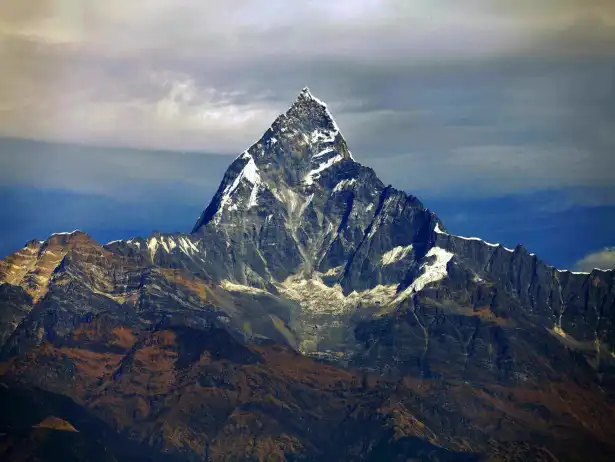
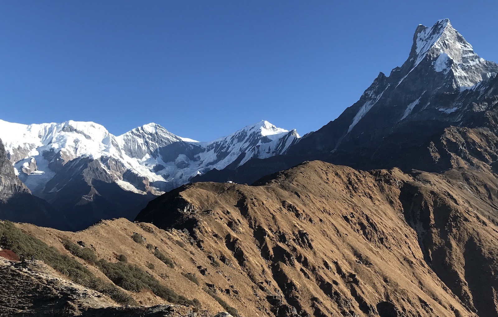
Steep, but rewarding ridgeline terrain is the defining characteristic of the Mardi Himal trek elevation profile. While rapidly gaining altitude each day, you're consistently in sight of Machhapuchhre at 6,993 m (22,943 ft) and the surrounding Annapurnas. The trail stays above 2,000 m after the first day, so you avoid the muggy, tropical lower regions for much of the journey. This altitude profile helps to explain why the trek feels both adventurous and yet very manageable for trekkers in moderate condition.
Mardi Himal Trek Elevation Profile Highlights :
A pure ridgeline path with rapidly increasing altitude each day
Uninterrupted panoramic mountain views in every direction
Significantly shorter than valley treks
The ideal balance of challenging altitude and achievability
A great choice for trekkers craving grand vistas without extended time away
Advantages of Ridge Trail Terrain :
Quickest route to high-altitude scenery
More open views than through dense forests
Numerous excellent photo opportunities
Efficient altitude progress beyond the initial climb
Days
Elevation Range
Daily Gain (Approx.) | Terrain Type
Trailhead to Low Camp
1,770 m to 3,000 m (5,807-9,843 ft)
800-1,200 m | Steep ridge ascent
Mid to High Camp
3,000 m to 4,500 m (9,843-14,764 ft)
500-800 m | Exposed high ridge
Viewpoint Summit
Up to 4,500 m (14,764 ft)
Final push | Panoramic ridgeline
Mardi Himal Altitude Overview :
In conclusion, understanding the Mardi Himal trek elevation profile illustrates its unique place in the Annapurna range. Its steep ridge geometry maximizes views while minimizing transit time. Contact Haven Holidays today to arrange your guided Mardi Himal trek and experience its stunning altitude changes.
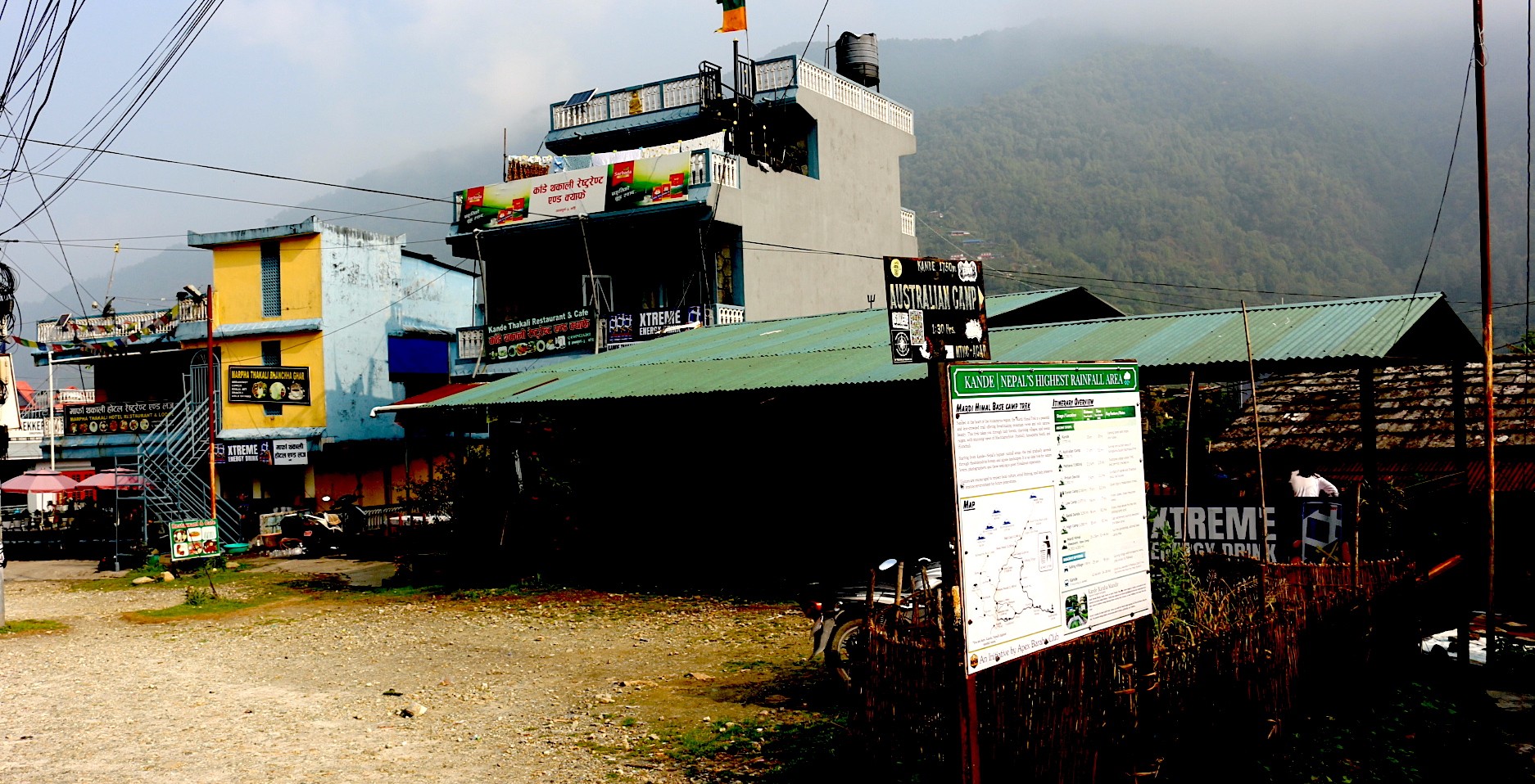
The Low-Altitude Gateway: From Pokhara to Kande Trailhead
Begin your journey on the Mardi Himal trek with a simple, scenic drive from Pokhara to the starting point. The 1.5-2 hour journey takes you from the lakeside city of Pokhara at 822 m (2,697 ft) to the official trailhead at Kande, perched at an altitude of 1,770 m (5,807 ft). By bypassing the extremely warm and humid lower elevation levels, you start your trek at a comfortable, moderate altitude which allows for superior acclimatization right from day one.
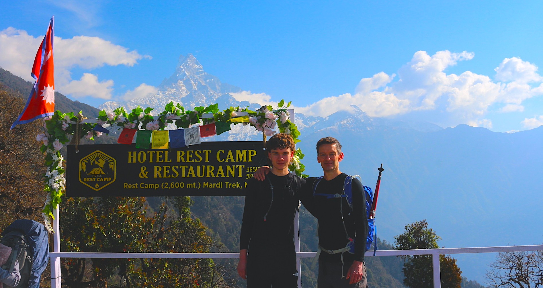
.Kande – the gateway to the Mardi Himal Trek, where the adventure begins beneath the Annapurna Himalayas.
Likewise, driving on mountain roads to the gateway to Mardi Himal at Kande provides excellent views of the foothills. When you reach the point where the Mardi Himal trek proper begins at Kande, the trail quickly rises steeply onto the ridges. This strategically elevated starting point makes the ascent much easier, eliminating the extensive time that many other treks spend navigating low-altitude forests.
Pokhara to Kande Drive Benefits :
Fast, uncomplicated road journey.
Skip the sweltering tropical lowlands completely.
Begin your trek at the pleasant elevation of 1,770 m (5,807 ft).
See the Annapurna range come into view on the drive.
A perfect entry to the unique ridgeline trail.
Starting Altitude Advantages :
Moderate elevation speeds up adaptation.
Less physical demand in the first hours of trekking.
Cooler mountain air from the beginning.
Optimal location to begin steady ridge ascent.
Segment
Elevation
Duration | Key Benefit
Pokhara City
822 m (2,697 ft)
Starting point | Comfortable Lakeside Setting
Drive to Kande
To 1,770 m (5,807 ft)
1.5-2 hours | Scenic and Efficient Transfer
First Trekking Steps
From 1,770 m upward
4-6 hours | Rapid Ascent onto Ridges
Initial Altitude Profile :
In conclusion, the low-altitude transfer from Pokhara to Kande Trailhead is a smart way to begin your Mardi Himal trek, setting the stage for fantastic views. Contact Haven Holidays today to plan your fully guided Mardi Himal trek, complete with smooth transfers.
The First Vertical Step: Ascending through Australian Camp to Pothana
Here, you leave the warm subtropical air of the Pokhara valley behind and enter instantly into a strenuous mountain climb. From the road trailheads of Kande or Phedi, your hiking experience begins immediately on the typical terrain of the lower Annapurnas:hand-cut stonesthat rise steeply through the terraces of local farms.
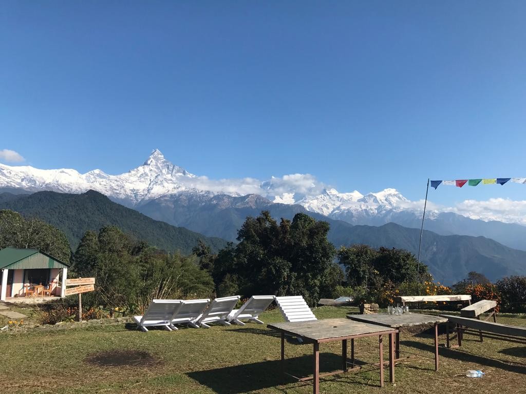
Australian Camp – a stunning viewpoint on the Mardi Himal Trek, offering breathtaking Himalayan panoramas and unforgettable mountain sunsets.
[Australian Camp Plateau: 2,060 m] Initial scenic high ridge
(Instant 360 meter vertical incline stone step ascent)
[Kande trailhead base: 1,700m]
Actually, this initial leg of the trip takes a bit of effort, but it’s short. The stone steps climb immediately gets your legs working, and you’ll quickly have to find a steady trekking rhythm. Your first real altitude achievement is Australian Camp, a beautiful grassy plateau that opens to spectacular mountain views. From this high ridge, you descend slightly through the trees to the village of Pothana where your trekking permits are verified.
Navigating the Foothill Climb :
The Staircase Start: From your entry into the foothills, the terrain transitions immediately to a strenuous climb of stone steps. You’ll need to find a slow, steady pace to sustain your breath.
The initial altitude climb: A brief climb to the initial elevation point lifts you quickly out of the valley haze and grants your lungs a mild first sense of initial altitude gain as you approach the 2000 meter level.
The ridge view reward: The open, manicured lawns of Australian Camp altitude (2,060m / 6,758 feet) reward you with a fantastic view of the Annapurna South and the Hiunchuli peaks.
The entry to the checkpoint: A gentle descent through trees along an oak-bordered path takes you to the Pothana checkpoint (1,890 m / 6,200 ft) where park officials confirm that you have the correct ACAP trekking permits.
Point Milestone
Altitude Range | Air Pressure
Nature of Terrain Challenge | Main function
Kande trailhead base
1,700 m / 5,577 feet | 83% sea level
Dirt pathways that pass beside farms; a rocky climb to start the trek. | The main entry point for trek and team of guides/porters assembly.
Australian Camp crest
2,060m / 6,758 feet | 79% sea level
Relentless upward stone steps and a tiring, steep slope. | First significant vertical benchmark and ridge viewpoint.
Pothana village node
1,890 m / 6,200 feet | 81% sea level
A gently sloping, undulating path through an oak forest. | The primary point for park permission checks and lodging establishment.
Terrain breakdown: Kande trailhead base to Pothana checkpoint :
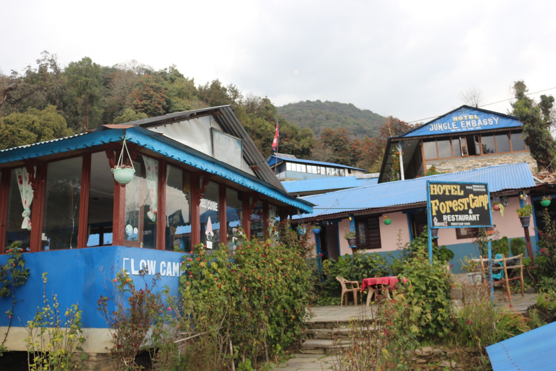
Entering the Jungle Ridge: The forest trek from Deurali to Forest Camp
After clearing the checkpoint points at Pothana, the farmlands transition quickly into wilderness. Instead of following the standard Annapurna hiking paths, you embark on a narrow ridge line that straddles the Modi Khola and the Mardi Khola valleys.
Forest Camp – a tranquil stop deep within the enchanting forests of the Mardi Himal Trek.
Actually, the trek begins with an upward push to Pritam Deurali pass elevation (2,100 m / 6,889 feet), then deviates from the usual Annapurna pathways onto a more hidden, untouched forest trail. You find yourself deep in a rhododendron forest covered in a thick blanket of moss, winding upward steadily until you reach a small, remote clearing.
The split off trail: At Pritam Deurali pass, you divert from the main trail into a hushed natural reserve where the distant city sounds are lost to the mountain wind and birds.
The canopies above: you continue trekking under the roof of a dense rhododendron and oak forest, shielded from the harsh daytime sun by layers of leaves, with cool, damp air all around.
The trail on the ground: the path becomes a soft, dirt track strewn with protruding tree roots and fallen leaves, a welcome alternative to the stone steps.
The wilderness lodging: After a consistent uphill ascent along a thin ridgeline, the dense trees abruptly yield a small clearing occupied by basic mountain lodges at Forest Camp elevation meters feet (2,550 m / 8,366 feet).
checkpoint
Elevation range | Oxygen density
Terrain challenge | Environment
Pritam Deurali pass
2,100m / 6,889 feet | 79% sea level
A steep, rocky slope with root-covered ground. | Windy ridge; very open to sun and elements.
Jungle Ridge Track
2,350 m / 7,710 feet | 77% sea level
A root-covered, soft dirt trail with a few slippery moss-covered stones. | Shaded forest canopy; cool and moist.
Forest Camp (Kokar)
2,550 m / 8,366 feet | 75% sea level
A sustained, steady uphill slope on a narrow ridgeline. | Enclosed forest clearing; cool temperatures drop in the evening.
Elevation chart: Pritam Deurali pass to Forest Camp:
Climbing the Green Tunnel to Low Camp
Welcome to the enchanting silence of the green tunnel as you continue your steady climb up the Mardi Himal Trek. This captivating section takes you through a thick rhododendron and oak forest on your way to Low Camp at 2,970 meters (9,744 feet). The trail is an uninterrupted, uphill journey completely surrounded by a lush, jungle-like canopy where filtered sunlight creates a magical atmosphere as you trek along the ridge.
Rest Camp – a perfect place to pause, recharge, and enjoy spectacular mountain views on the Mardi Himal Trek.
Actually, this is the final fully forested camp you will encounter before the magnificent mountain views burst forth in a breathtaking panorama. The change in alpine vegetation becomes evident as the tall trees begin to intermingle with smaller shrubs and brightly colored flowers. The constant ascent also builds your stamina, providing you with tranquil moments filled with birdsong and the crisp mountain air. Inevitably, reaching Low Camp feels like a well-deserved reward as you ascend higher into the mountains.
Low Camp Altitude Featuresn :
Located at 2,970 m (9,744 ft) on a beautiful, wooded saddle
Cozy teahouses perfectly situated within the green tunnel
An ideal place to rest and spend the night
The last entirely forested camp before the open ridges
A peaceful environment abundant in natural life
Green Tunnel Trek Highlights :
A constant, uphill climb through a dense, jungle canopy
A noticeable shift in alpine flora, with rhododendron playing a key role
Glimpses of quiet mountain viewpoints between the trees
Develops a strong, steady rhythm for your trekking and strengthens your legs
A transitional area that prepares you for the dramatic scenery that awaits
Segment
Elevation
Terrain Description | Walking Time
Kande to Mid Ridge
1,770 m to 2,500 m (5,807-8,202 ft)
Steep forested trail | 3-4 hours
Mid Ridge to Low Camp
To 2,970 m (9,744 ft)
Continuous green tunnel ascent | 3-4 hours
Elevation Progress to Low Camp :
In conclusion, the trek through the green tunnel to Low Camp is a memorable, forest-filled journey that provides a lovely contrast to the open views that will soon greet you. This segment builds your strength and spirit as you move to higher elevations. For this unforgettable portion of the Mardi Himal Trek, contact Haven Holidays to book your guided adventure.
Passing the Tree Line to High Camp
Witness a spectacular transformation of the landscape as you finally cross the tree line and enter the open alpine world on your Mardi Himal Trek. This incredible segment takes you past Badal Danda at 3,210 meters (10,531 feet) where the forest finally gives way to sweeping open ridges. You’ll be walking above the cloud line along an exposed alpine ridge, relishing the liberating sensation of the high mountains before reaching your destination: High Camp at 3,550 meters (11,646 feet).
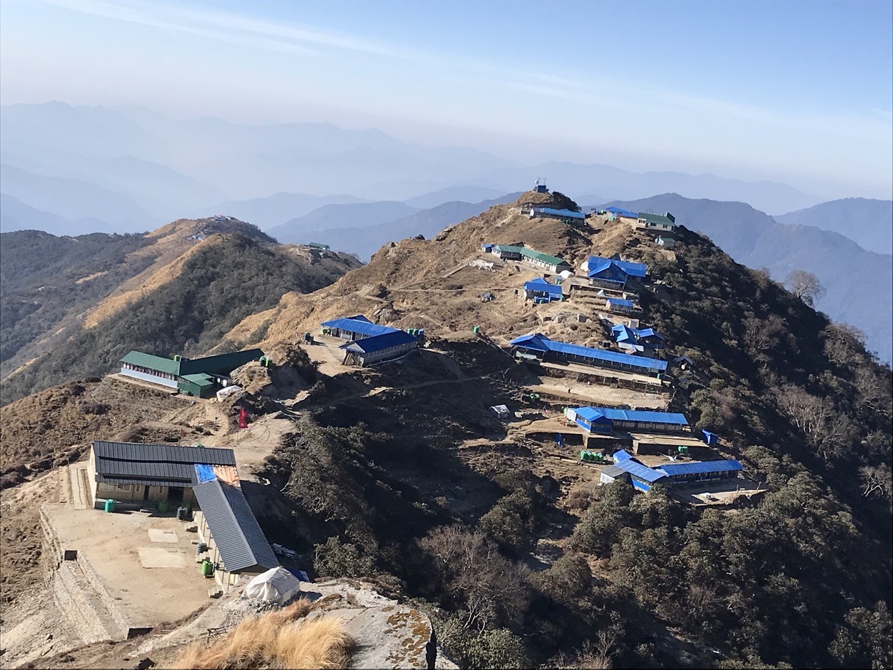
High Camp Lodges – a breathtaking overnight stop above the clouds with spectacular Himalayan mountain views.
Actually, the feeling of leaving the last trees behind and stepping out onto broad, wind-swept slopes is a powerful and unforgettable altitude shift. The views of Machhapuchhre at 6,993 meters (22,943 feet) and the Annapurna ranges are suddenly vast and clear in every direction. Coupled with the thinning air and panoramic surroundings, this is one of the most rewarding days on the trek, positioning you perfectly for your final push to the viewpoint.
Badal Danda Elevation Highlights :
A pivotal landmark at 3,210 m (10,531 ft)
The official transition point from forest to open ridge
Offers the first panoramic views above the cloud line
A crucial rest stop during this dramatic altitude shift
A place to soak in the breathtaking mountain scenery
High Camp Altitude Features :
Your primary overnight stop at 3,550 m (11,646 ft)
Situated on an exposed ridge with incredible 360-degree views
Comfortable teahouses available for high-altitude stays
An ideal base for acclimatization and the final trek to the summit viewpoint
A dramatic, high-alpine environment above the tree line
Segment
Elevation
Key Transition | Walking Time
Low Camp to Badal Danda
2,970 m to 3,210 m (9,744-10,531 ft)
Forest thinning to open ridge | 2-3 hours
Badal Danda to High Camp
To 3,550 m (11,646 ft)
Full alpine zone, above clouds | 2-3 hours
Tree Line Crossing Overview :
In conclusion, the crossing of the tree line and arrival at High Camp provide a dramatic and awe-inspiring altitude shift that defines the Mardi Himal trekking experience. This momentous change rewards your efforts with unparalleled open vistas. To conquer these iconic ridges, contact Haven Holidays today and book your guided Mardi Himal Trek adventure.
Strategic Acclimatization: Why High Camp Is Your Essential Altitude Buffer
Due to the Mardi Himal’s compressed 4 to 5 day trek schedule, it lacks the integrated rest days typically incorporated in more extensive mountain climbs. As a consequence, its overall elevation profile is quite direct and steep. Your overnight stop at High Camp becomes the principal shield against thin air, providing the necessary duration for your body to adjust before attempting the trek’s peak vantage point.
[Mardi Himal Viewpoint Peak: 4,200 m]- (+650 m Pre-Dawn Push)
[High Camp Acclimatization Buffer: 3,550 m] Critical Night Stop / Air Adaptation- (+580 m Thin Air Ascent)
[Low Camp Ridge Station: 2,970 m]
In fact, overnight above 3000 meters signals a dramatic transition for the respiratory system. Once you cross this threshold, atmospheric pressure is low enough that the air you inhale contains measurably fewer oxygen molecules in each breath. Ascending from Low Camp to High Camp with a moderate, consistent pace is by far the most critical technique to promote altitude sickness prevention for Mardi Himal treks.
High Camp Ascent Management :
The Oxygen Drop: Reaching High Camp (3,550 meters / 11,647 feet) signifies walking through air that has about 65% of the oxygen available at sea level, thereby consistently challenging your respiratory function.
Pacing Defense: The trail connecting these camps winds along a wind-exposed, narrow ridge line. Traversing this route at a measured, unhurried pace curtails increases in heart rate, effectively impeding the onset of mountain sickness.
Proactive Hydration: The frigid, arid air of the mountains rapidly dehydrates the body. Ingesting 4 to 5 liters of fluids per day sustains a stable blood volume, aiding the natural adaptation of your breathing mechanisms.
Identifying Initial Symptoms: Use High Camp as an active opportunity to monitor your well-being. Persistent headaches, mild dizziness, or difficulties sleeping are clear indicators that you need to rest and allow for acclimatization, rather than press onward.
Altitude Zone Milestone
Elevation Metrics | Available Oxygen Level
Common Physiological Adjustments | Required Field Action
Low Camp Outpost
2,970 m / 9,744 ft | ~71% of sea level
Increased breathing during exertion; deeper sleeping patterns. | Maintain a steady pace; drink ample fluids.
High Camp Buffer
3,550 m / 11,647 ft | ~65% of sea level
Elevated resting heart rate; mild breathlessness during movement. | Get adequate rest; consume warm meals; observe your body.
High-Altitude Acclimatization Metric Matrix :
Pre-Dawn Alpine Ridge Walk: Summit Push to Mardi Himal Viewpoint
Here, the climb to the trek's highest point commences in the predawn darkness. Depart from High Camp at 4 AM, embarking on a pitch-black mountain ridge, where the frozen grass crunches underfoot and the wind carries a chilling breath from the Annapurna South glaciers.
Mardi Himal Viewpoint – one of Nepal’s most spectacular vantage points with unforgettable Himalayan mountain scenery.
[Mardi Himal Viewpoint: 4,200 m] Prime Sunrise Spot (Facing Machhapuchhre)- (+650 m Constant Alpine Ridge Ascent)
[High Camp Trailhead: 3,550 m]
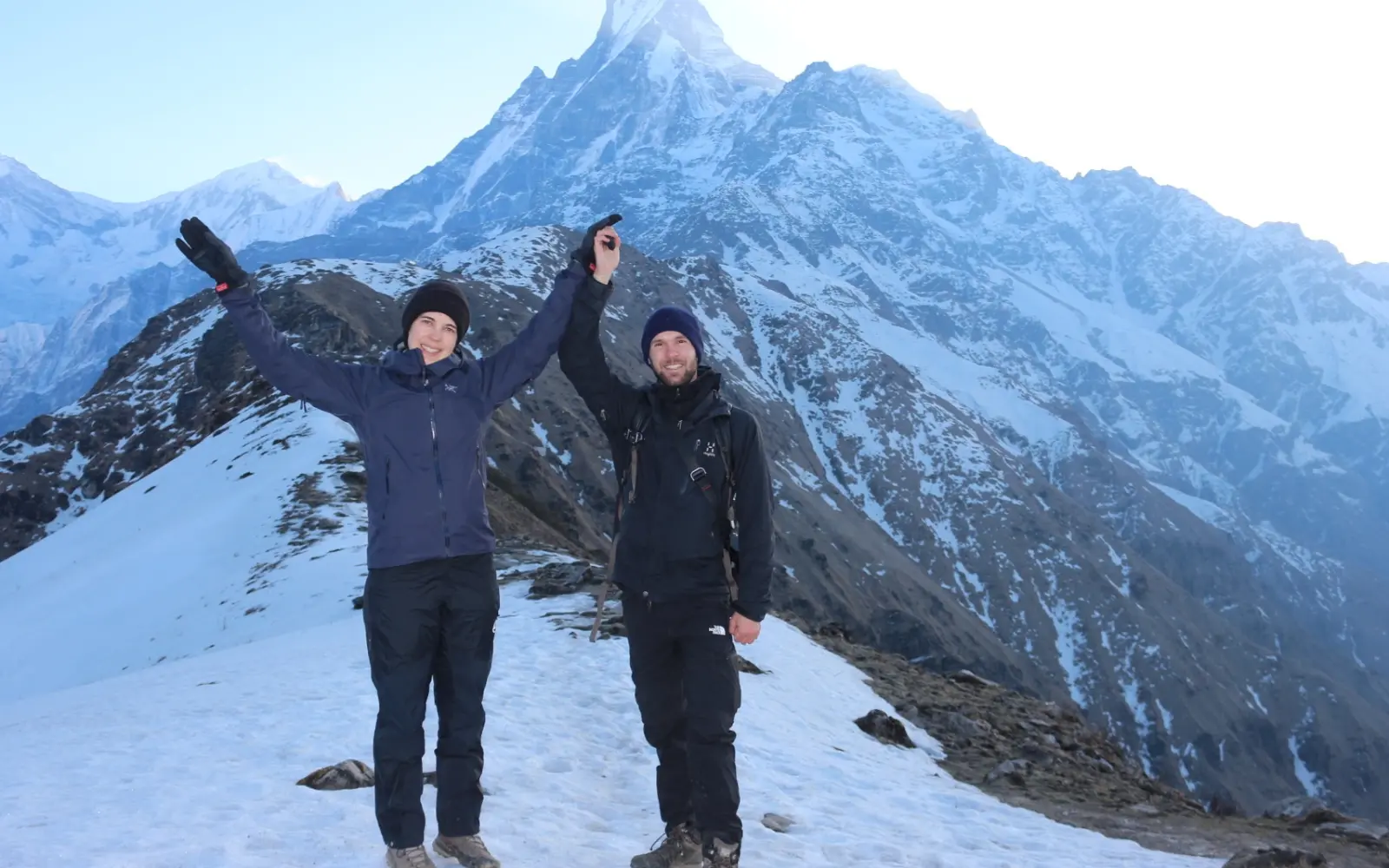
Actually, this final section follows a breathtaking alpine path. Navigating the narrow ridge trail safety requires utmost concentration as the ground plunges away into the shadowy depths of the Modi Khola and Mardi valleys on either side. Illuminating your path with a headlamp, you ascend through the thin air to reach the Mardi Himal viewpoint elevation of 4,200 meters (13,779 feet) just as the sun's rays strike the peaks.
The Morning Ridge Climb:
Alpine Incline: The trail is steep, traversing frozen dirt, open meadows, and slick rocks, demanding careful foot placement in the darkness.
Cold Air Strain: At 4,200 meters, the air's thinness makes each step feel labored. Maintaining deep, steady breathing is essential to conserve energy on the steep upper sections.
Ridge Edge Trail: The path lies directly along the mountain's spine. Walking deliberately in the center of the trail ensures your stability on the exposed segments.
Mountain Sunrise: Arriving at the viewpoint offers a phenomenal Machhapuchhre sunrise, with the iconic 6,993-meter peak bathed in a brilliant golden light directly ahead.
Route Station Landmark
Elevation Metric | Barometric Air Pressure
Technical Footing Type | Environmental Conditions
High Camp Departure
3,550 m / 11,647 ft | ~65% of sea level
Steep switchbacks on frozen earth with loose gravel. | Extreme darkness; freezing wind; sub-zero temperatures.
Middle Ridge Spur
3,900 m / 12,795 ft | ~62% of sea level
Narrow dirt paths on exposed grassy slopes. | Early morning light; cold wind off the glaciers.
Mardi Himal Viewpoint
4,200 m / 13,779 ft | ~60% of sea level
Open, rocky areas with large boulders | Direct morning sun; expansive mountain vistas.
Summit Push Profile: High Camp to Viewpoint
The Utmost Apex: Reaching Mardi Himal Base Camp
Now picture yourself at the absolute apex of your Mardi Himal Trek, utterly surrounded by wild glacial beauty and enormous peaks. The optional, though thoroughly worthwhile, extension beyond the main viewpoint guides you across wild, wind-blasted alpine moraine to Mardi Himal Base Camp, standing at an impressive 4,500 meters (14,763 feet)-the highest point on your trek. This taxing, final push, complete with raw glacial terrain and an eye-popping, close-up view of the 6,993 meter (22,943 foot) Machhapuchhre, will give you an unparalleled sense of achievement.
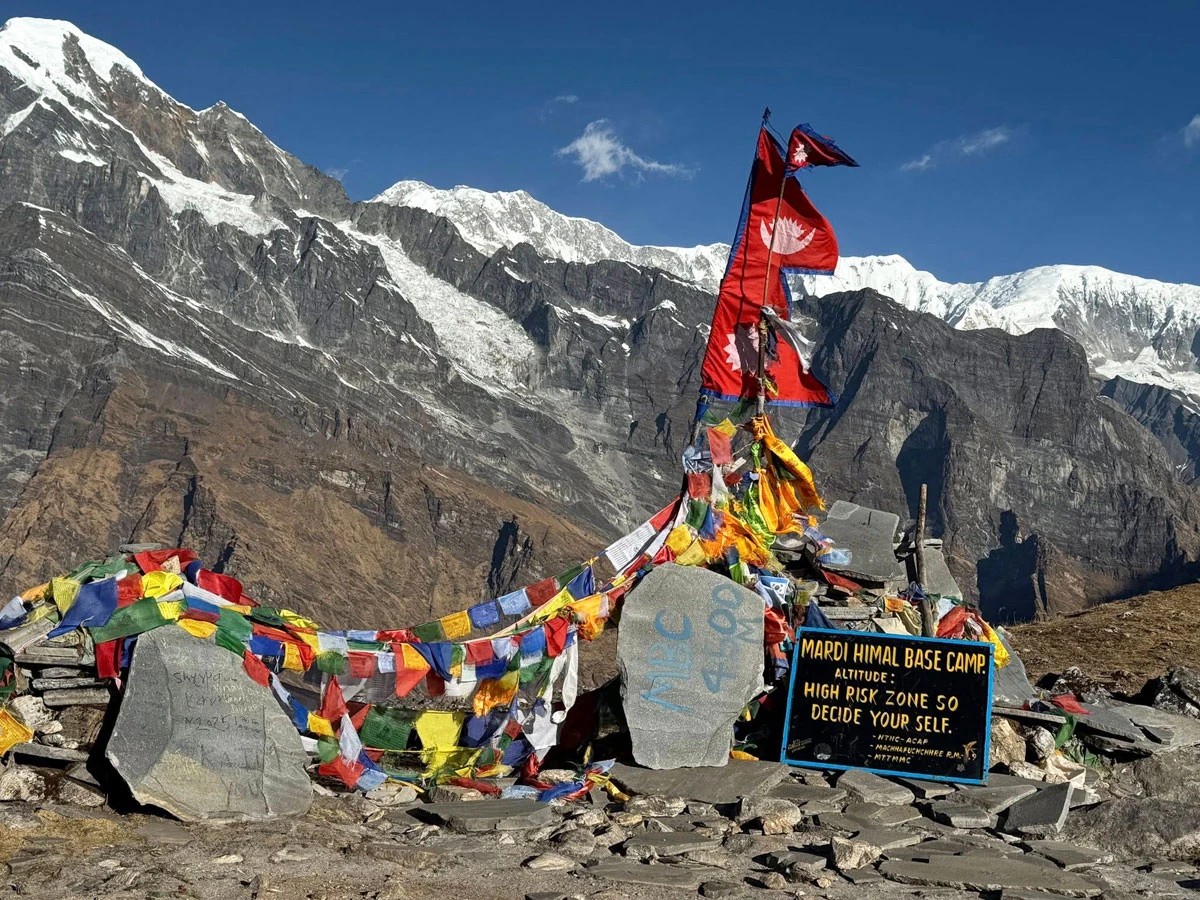
Mardi Himal Base Camp – the ultimate destination of the trek, offering close-up views of some of the most stunning peaks in the Annapurna region
Actually, the trail from the viewpoint to Mardi Himal Base Camp meanders across rocky moraine and into open ridges, where the wind feels mighty and the air, thin and pure. You'll make your way along treacherous glacial moraine terrain which is hard on the legs and balance, but you're rewarded with an entrance into a cathedral-like bowl beneath the towering mountain. Moreover, the 360-degree panoramic view at maximum altitude make it all worthwhile. Henceforth, for fit trekkers who truly want the complete Mardi Himal experience, getting to Base Camp will be the apex.
Mardi Himal Base Camp Maximum Altitude Highlights :
Highest point on trek (4,500 m / 14,763 ft)
Optional but physically demanding glacial moraine crossing
Unforgettable close-up views of Machhapuchhre and other high peaks
Primal alpine environment with powerful atmosphere
Absolute sense of accomplishment
Glacial Moraine Terrain Characteristics :
Uneven, rocky terrain
Exposed ridgelines exposed to the elements
Walking on centuries-old glacier debris
Wild high-altitude experience
The ultimate payoff
Segment
Elevation Range
Terrain Type | Duration
Viewpoint to Base Camp
Up to 4,500 m (14,763 ft)
Glacial moraine and ridgeline | 2-3 hours.
Exploration at Base Camp
4,500 m (14,763 ft)
360° panoramic views | 1 hour.
Return descent to High Camp
Down to 3,550 m (11,646 ft)
Same moraine trail | 2 hours.
Extension Breakdown :
In summary, Mardi Himal Base Camp offers the pinnacle achievement on the trek, culminating at its highest elevation in spectacular glacial moraine terrain that only a determined hiker can experience. Contact Haven Holidays today and add this apex to your guided Mardi Himal trek package!
Total Vertical Gain and Daily Elevation Ascent: Will it be too much climbing?
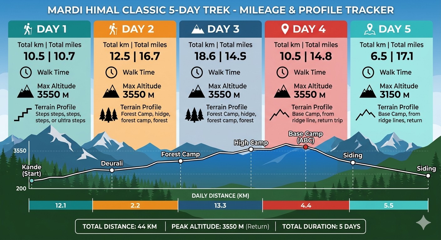
Let's get real about the numbers before you pull on your trekking boots for the Mardi Himal Trek. The trek has a colossal elevation gain of 2,730 meters (8,956 feet) from the Kande starting point at 1,770 meters (5,807 feet) all the way up to the Mardi Himal Base Camp at 4,500 meters (14,763 feet). This incredible total ascent packed into a scant 3-4 days of climbing make it a demanding, but feasible, challenge for moderately fit hikers.
Likewise, you'll typically hike 5 to 7 hours per day, with a majority of your climbs happening in the first three days. Significant elevation will be gained each day, stacking up fast but providing consistent mountain views. Plus, since it’s a ridge line, the gradient doesn't stay flat but is a steady rise to the top. Because of this, strong legs, decent cardiovascular ability, and practice with inclines are absolutely crucial.
Total Elevation Gain Summary :
Net vertical gain: 2,730m (8,956ft) from Kande to Base Camp Occurs over 3-4 key climbing days Averaging between 700-1,000m gain per day Descent is a significant but less taxing experience Shorter in total than most other Annapurna routes
Day / Stage
Starting Altitude
Approximate Gain | Hours Hiked | Difficulty
Kande to Low Camp
1,770 m (5,807 ft)
+1,200 m | 6-7 hours | Challenging
Low Camp to High Camp
2,970 m (9,744 ft)
+580 m | 5-6 hours | Gradual
High Camp to Viewpoint/Base Camp
3,550 m (11,646 ft)
+950 m | 5-6 hours | Demanding
Daily Elevation Climb Overview :
Physical Fitness Demands :
Strong, sturdy legs and stable knees for ridge climbing
Good lung and heart capacity for steady uphill work
Previous hill-walking and trekking experience recommended
Mental toughness and endurance for high altitude exposure
Stay well-hydrated and listen to your body
To conclude, the total elevation gain on the Mardi Himal trek is undeniably steep-2,730m (8,956ft) from Kande to Mardi Himal Base Camp, but its concentration over a few days makes it achievable for hikers who have prepared themselves. The daily vertical ascent yields fantastic, sweeping views as you progress higher. Contact Haven Holidays to review your fitness and arrange the perfect guided Mardi Himal trek for your capabilities.
The Quick but Knee-Crunching Descent: From Low Camp and down Siding Village
Bring your Mardi Himal journey to an end with a spectacular quick-track downhill via Siding village. Instead of going back down the entire ridge you dropped from, you make a steep descent from High Camp or Low Camp down to the traditional Brahman and Gurung settlement of Siding at 1,700 meters (5,577 feet). This loop back makes for a geometrically asymmetric trip; a scenic climb up the Kande-Forest Camp Ridge and a rapid drop down the direct Siding Village route.
Likewise, the steep path down requires vigilance and your knees bear the brunt; so don't forget trekking poles to help ease the stress on your joints. This route will also take you through dense forests and terraces and contrast with the high mountain ridges; thus it speeds up the journey back while still providing cultural immersion and slightly easier breathing at lower altitude.
Siding Village Descent Advantages :
Asymmetrical loop routing for efficiently getting up the mountain and back
Time efficient compared to coming all the way back up the ridge
Opportunity to immerse oneself in authentic Gurung and Brahmin life
Rapid and drastic change in landscape
Great views of the local life at a higher altitude
Tips to Reduce Knee Pain during Steep Descent :
Use trekking poles to offload weight from your knees
Keep pace in control and take small steps
Stop for mini-breaks to rest on steeper sections
Stay well hydrated
Get some light stretching done in the evening at the teahouses
Segment
Elevation Change
Terrain & Condition | Travel Time
High Camp to Low Camp
3,550 m - 2,970 m (11,646-9,744 ft)
Forested, very steep ridge | 2 - 3 hours.
Low Camp to Siding Village
Down to 1,700 m (5,577 ft)
Rapid descent through terraces | 4 - 5 hours.
Siding to Roadhead
Continued downhill
Village path and jeep track | 1 - 2 hours.
Elevation Change from High Camp Descent Profile :
To sum up, a fast-track knee-pounding journey down to Siding village is the most economical and scenic way to end your Mardi Himal trek, taking in some stunning sights on the way up and completing the loop with efficiency. Get in touch with Haven Holidays to begin the journey of planning your own guided Mardi Himal Trek with a carefully designed return route!
Conclusion: Summary Chart of Mardi Himal Altitude Variation
Put an end to your Mardi Himal Trek planning dilemma with this useful altitude summary. The Mardi Himal trek, with its asymmetry in terms of ascending the scenic ridge from Kande and descending from Siding village, maximizes the views you can see while also being efficient. Use this quick reference itinerary and trail checklist for your preparation.
"The highest point of the standard Mardi Himal Trek is 4,200 meters at the viewpoint, although Base Camp lies at 4,500 meters."
Day | Stage/Camp
Elevation (m / ft)
Average Hours Walked | Trail Condition | Highlights
6 - 7 hrs | Dense forest, steady uphill | First part of the climb, forest immersion.
3 | Low Camp to High Camp
2,970 m - 3,550 m (9,744-11,646 ft)
5 - 6 hrs | Open ridge, above tree-line | Badal Danda (Cloud Hill) and views.
4 | High Camp to Viewpoint/Base Camp
3,550 m - 4,500 m (11,646-14,763 ft)
5 - 6 hours | Moraine above the tree line, alpine | Apex of the trek, vast glacial scenery
5 | Descent to Siding
4,500 m - 1,700 m (14,763-5,577 ft)
6 - 7 hours | Steep downhill, through terraces | Fast descent, local village.
Mardi Himal Day-by-Day Elevation :
Trail Summary Checklist :
Total elevation gain: 2,730 m (8,956 ft)
Suitable for reasonably fit trekkers who don't mind a sharp descent and have strong knees
Relatively short but steep ridge trail in the Annapurna region
Best months: Spring and Autumn
Best taken with an experienced local guide
In conclusion, this summary master chart is your ideal pocket planner. Whether you decide on the full base camp route or the Standard viewpoint, the Mardi Himal Trek is sure to offer a variety of breathtaking elevation shifts and incredible scenery. Reach out to Haven Holidays today and let us design your ideal Mardi Himal trek.
Mardi Himal Trek Elevation Profile Details-FAQs
1. What is the beginning altitude of the Mardi Himal trek? The initial beginning altitude of the Mardi Himal trek is somewhat dependent on the starting point you pick. Many classic itineraries begin their trek on foot at Kande at an altitude of 1,770 meters (5,807 feet), whereas some other routes involve a short Jeep ride from Pokhara to start the walk from either Phedi or Dhampus.
2. What are the highest and lowest altitude points of the Mardi Trek? The highest and lowest altitude of the Mardi Trek spans across an enormous vertical range; the absolute low is the starting trailhead around Pokhara at approximately 1,000 to 1,770 meters, and the absolute highest geographical feature you ascend to on the trail is at Upper Viewpoint and base Camp.
3. What is the exact Mardi Himal Base Camp altitude? The official Mardi Himal Base Camp altitude is 4,500 meters (14,763 feet) above sea level. This alpine sanctuary sits right at the base of the massive Machhapuchhre ridge, offering an unprecedented up-close vista to trekkers as they find themselves directly underneath this majestic peak.
4. What is the standard maximum Mardi Himal elevation reached overnight? Although base Camp itself marks the furthest extent of the trail on a typical trek, the highest Mardi Himal elevation for sleeping over is generally at High Camp which is about 3,580 meters (11,745 feet), the last place where you spend the night before the early morning assault to higher vantage points.
5. How severe is the daily altitude gain and loss on the Mardi Himal trek? The altitude gain and loss on the Mardi Himal trek is extremely rapid since you walk in a single, steep line right up a ridge, not in a broad valley. You will frequently encounter a Net gain of 800 to 1,000 vertical meters in a single trekking day.
6. Is the Mardi Himal trek altitude profile suitable for beginners? Although the rapid daily altitude gain and loss on the Mardi trek might challenge a beginner physically, it is considered an accessible option due to its shorter duration compared to other Annapurna treks. However, strong cardiovascular health and resilient knees are essential due to the continuous, vertical climb on the trail and the often treacherous descent.
7. What is the elevation of Forest Camp on the Mardi Trek? Forest Camp which is locally known as Kokar sits at a tranquil Mardi Himal elevation of 2,520 meters (8,267 feet). This secluded spot surrounded by dense woods serves as the regular first night's halt for trekkers journeying from a low-altitude trailhead like Kande or Phedi.
8. What is the altitude variation between Forest Camp and Low Camp? You continue climbing moderately from Forest Camp (2,520m) to Low Camp at 2,970 meters (9,744 feet) and the altitude changes aren't too substantial on this stretch. The trail is fairly scenic as you move through rhododendron and oak forests keeping the daily altitude gain and loss at reasonable levels.
9. Why does the trail feel steeper past the Low Camp altitude profile? From Low Camp (2,970m) the Mardi Himal trek altitude profile transitions to the shrub-covered, non-forested alpine terrain above the tree-line. The path narrows as you stride towards Badal Danda (3,250m) and then High Camp (3,580m) exposing trekkers to brisk, cold mountain air and a significantly steeper trail.
10. What is the elevation of High Camp on the Mardi Himal trek? High Camp is strategically located on a wide, breezy, and grassy ridge at a height of 3,580 meters (11,745 feet). It is the last campsite where trekkers spend the night on the Mardi Trek, requiring participants to maintain a high water intake to reduce any possibility of mild headaches due to the elevation.
11. What is the vertical layout of the morning hike to Upper Viewpoint? The hike to the awe-inspiring Upper Viewpoint (4,200m) from High Camp (3,580m) involves an altitude climb of 620 meters over two to three hours of steep walking along narrow, rocky paths lining the ridge-line so that trekkers can be there early to watch the sunrise over the Himalayas.
12. How much further is it from Upper Viewpoint to Mardi Himal Base Camp? After reaching the Upper Viewpoint (4,200m) at this remarkable Mardi Himal Base Camp altitude, you have a further one to two-hour trek along a tough and exposed rocky ridge path to reach the base Camp.
13. How does oxygen availability change across the Mardi Himal trek? While the entire trail at the lower beginning altitude has full atmospheric pressure available to its trekkers, at the higher altitude end of the trail where the Mardi Himal Base Camp is located at 4,500 meters, the effective oxygen availability drops to roughly 57% compared to the sea level reading.
14. What is the best strategy to manage the rapid Mardi Trek difficulty? The best way to cope with the steep, fluctuating Mardi Trek elevations is to stick to the 'bistari, bistari' pacing principle of walking "slowly, slowly" to allow your body adequate time to adjust to the changing altitudes; along with drinking at least four to five liters of water per day.
15. Are there mandatory acclimatization days on a standard Mardi Himal itinerary? As the Mardi Himal trek is typically a 5- to 6-day affair, there is no mandatory full rest day built into the schedule. The overnight hikes between consecutive camping stages effectively build in a constant, albeit natural, acclimatization period to manage the ascent.
16. What is the standard descent altitude profile on the return leg of Mardi Himal? The descent journey presents an extraordinarily fast altitude loss as most trekkers will cover a great distance from base Camp at 4,500 meters all the way down to Low Camp or the lovely village of Siding (1,700m) in one single day putting substantial strain on the knees.
17. How does the weather vary across the Mardi Himal elevation profile? The weather changes significantly based on altitude; starting off as warm and humid at lower elevations, the climate rapidly turns colder at higher elevations past the tree-line, with night time temperatures dropping below zero at High Camp to -5C (23F) in the spring and autumn trekking season.
18. Is travel insurance required for the Mardi Himal trek altitude profile? Yes, having travel insurance covering high altitudes is highly recommended. Since the highest point of the Mardi Trek exceeds 4,000 meters, your policy needs to include medical helicopter evacuation cover up to at least 5,000 meters, ensuring your safety in the event of a medical emergency.
19. What major peaks are visible from the highest points of the Mardi Trek? The top Mardi Himal elevation viewpoints are rewarding and show you some of the most iconic mountains including the imposing South Face of Machhapuchhre, Annapurna South, Hiunchuli, Gangapurna, Mardi Himal and even a distant view of the enormous Dhaulagiri massif creating an unmatched panorama.
20. What is the overall success rate for the Mardi Himal trek? With most trekkers successfully reaching the summit, the overall success rate for the Mardi Himal trek is around 95 percent. While the destination of 4,500 meters is quite high, the short route and minimal number of nights spent above 3,500 meters compared to Everest Base Camp ensure that nearly every healthy individual can complete the trek.