[{"name":"Everest Base Camp Helicopter Tour","duration":"1","image_url":"https:\/\/www.havenholidaysnepal.com\/storage\/trip-galleries\/1\/thumb_6cd53005d75a86e373d31419d1b14d78.webp","offer_price":1195,"url":"https:\/\/www.havenholidaysnepal.com\/trips\/everest-base-camp-helicopter-tour"},{"name":"Everest Mountain Flight","duration":"1","image_url":"https:\/\/www.havenholidaysnepal.com\/storage\/trip-galleries\/4\/thumb_3b0b4f1d6f72b0ad224daf4752f2c6e0.jpg","offer_price":285,"url":"https:\/\/www.havenholidaysnepal.com\/trips\/everest-mountain-flight"},{"name":"Everest Short Trek","duration":"9","image_url":"https:\/\/www.havenholidaysnepal.com\/storage\/trip-galleries\/5\/thumb_BXPP3621.JPEG0.02033800 1727957098.webp","offer_price":895,"url":"https:\/\/www.havenholidaysnepal.com\/trips\/everest-short-trek"},{"name":"Gokyo Valley Trek","duration":"12","image_url":"https:\/\/www.havenholidaysnepal.com\/storage\/trip-galleries\/6\/thumb_10bc469b14731f23d3ce84a7092ad53f.jpg","offer_price":1195,"url":"https:\/\/www.havenholidaysnepal.com\/trips\/gokyo-valley-trek"},{"name":"15 days Annapurna Base Camp Trek","duration":"15","image_url":"https:\/\/www.havenholidaysnepal.com\/storage\/trip-galleries\/7\/thumb_87d1533bc45faf070990aef0579e4be4.jpg0.81855100 1728285496.webp","offer_price":785,"url":"https:\/\/www.havenholidaysnepal.com\/trips\/15-days-annapurna-base-camp-trek"},{"name":"Nepal Pilgrimage Tour","duration":"14","image_url":"https:\/\/www.havenholidaysnepal.com\/storage\/trip-galleries\/8\/thumb_02c3bcf2ad2e8a4c1703e90ae747b5f1.jpg","offer_price":1475,"url":"https:\/\/www.havenholidaysnepal.com\/trips\/nepal-pilgrimage-tour"},{"name":"UNESCO World Heritage Site Tour","duration":"10","image_url":"https:\/\/www.havenholidaysnepal.com\/storage\/trip-galleries\/9\/thumb_unesco-world-heritage-site-Lumbani-temple-buddhists-hindus-kathmandu-nepal0.36988600 17347617740.93089500 1737469667.webp","offer_price":715,"url":"https:\/\/www.havenholidaysnepal.com\/trips\/unesco-world-heritage-site-tour"},{"name":"Island Peak Climbing","duration":"16","image_url":"https:\/\/www.havenholidaysnepal.com\/storage\/trip-galleries\/11\/thumb_Island peak0.53947000 1734692503.webp","offer_price":2495,"url":"https:\/\/www.havenholidaysnepal.com\/trips\/island-peak-climbing"},{"name":"Upper Mustang Trek","duration":"18","image_url":"https:\/\/www.havenholidaysnepal.com\/storage\/trip-galleries\/12\/thumb_upper mustang 7 Oct-2024.jpg0.95398900 1728286166.webp","offer_price":2995,"url":"https:\/\/www.havenholidaysnepal.com\/trips\/upper-mustang-trek"},{"name":"Annapurna Circuit Trek","duration":"16","image_url":"https:\/\/www.havenholidaysnepal.com\/storage\/trip-galleries\/15\/thumb_tibetan-flags.jpg0.04843900 1728289138.webp","offer_price":985,"url":"https:\/\/www.havenholidaysnepal.com\/trips\/annapurna-circuit-trek"},{"name":"Gosainkunda Lake Trek","duration":"10","image_url":"https:\/\/www.havenholidaysnepal.com\/storage\/trip-galleries\/16\/thumb_5A8083B3-C007-41A8-853F-D0C37C97D235_1_105_c.jpeg0.52581200 1731845258.webp","offer_price":595,"url":"https:\/\/www.havenholidaysnepal.com\/trips\/gosainkunda-lake-trek"},{"name":"Zip-lining in Pokhara and Dhulikhel","duration":"1","image_url":"https:\/\/www.havenholidaysnepal.com\/storage\/trip-galleries\/18\/thumb_215f765e2ebc995dd5c800b4bfdbacc3.jpg","offer_price":82,"url":"https:\/\/www.havenholidaysnepal.com\/trips\/zip-lining-in-pokhara-and-dhulikhel"},{"name":"Annapurna Heli Tour","duration":"1","image_url":"https:\/\/www.havenholidaysnepal.com\/storage\/trip-galleries\/19\/thumb_d71a6bbb9fd4da8d1b567a5cdbdec85d.jpg","offer_price":555,"url":"https:\/\/www.havenholidaysnepal.com\/trips\/annapurna-heli-tour"},{"name":"Paragliding in Pokhara","duration":"1","image_url":"https:\/\/www.havenholidaysnepal.com\/storage\/trip-galleries\/20\/thumb_de788d2dd9726783431f882c007efae1.jpg","offer_price":65,"url":"https:\/\/www.havenholidaysnepal.com\/trips\/paragliding-in-pokhara"},{"name":"Ultra-Flight in Pokhara","duration":"1","image_url":"https:\/\/www.havenholidaysnepal.com\/storage\/trip-galleries\/21\/thumb_e27a9fb572a5c21611bb2a3c18e4b8f0.jpeg","offer_price":175,"url":"https:\/\/www.havenholidaysnepal.com\/trips\/ultra-flight-in-pokhara"},{"name":"Sarangkot Hiking","duration":"1","image_url":"https:\/\/www.havenholidaysnepal.com\/storage\/trip-galleries\/22\/thumb_100ef822fea19987166c6c1366215f15.jpg","offer_price":55,"url":"https:\/\/www.havenholidaysnepal.com\/trips\/sarangkot-hiking"},{"name":"Mera Peak Climbing","duration":"18","image_url":"https:\/\/www.havenholidaysnepal.com\/storage\/trip-galleries\/24\/thumb_d16ae3895f678cf26ffbf2455f541fb5.jpg0.31883400 1732617790.webp","offer_price":2475,"url":"https:\/\/www.havenholidaysnepal.com\/trips\/mera-peak-climbing"},{"name":"Lower Dolpo Trek","duration":"18","image_url":"https:\/\/www.havenholidaysnepal.com\/storage\/trip-galleries\/26\/thumb_Dolpo Galary - 1.JPG0.37725200 1727939952.webp","offer_price":2995,"url":"https:\/\/www.havenholidaysnepal.com\/trips\/lower-dolpo-trek"},{"name":"Nagarkot Sunrise\/Sunset Tour","duration":"1","image_url":"https:\/\/www.havenholidaysnepal.com\/storage\/trip-galleries\/27\/thumb_5147a5532644283a380f2e86f3857c13.jpg0.17748000 1728488108.webp","offer_price":30,"url":"https:\/\/www.havenholidaysnepal.com\/trips\/nagarkot-sunrise-sunset-tour"},{"name":"16 day Everest Base Camp Trek","duration":"16","image_url":"https:\/\/www.havenholidaysnepal.com\/storage\/trip-galleries\/28\/thumb_IMG_4311.JPG0.64984800 1727942213.webp","offer_price":1475,"url":"https:\/\/www.havenholidaysnepal.com\/trips\/16-day-everest-base-camp-trek"},{"name":"Ghorepani Poon Hill trek with Jungle Safari and Trishuli River Rafting -13 days","duration":"13","image_url":"https:\/\/www.havenholidaysnepal.com\/storage\/trip-galleries\/29\/thumb_Ghorepani Poon hill.jpg0.48460800 1728281439.webp","offer_price":795,"url":"https:\/\/www.havenholidaysnepal.com\/trips\/ghorepani-poon-hill-trek-with-jungle-safari-and-trishuli-river-rafting--13-days"},{"name":"Mardi Himal Trek","duration":"12","image_url":"https:\/\/www.havenholidaysnepal.com\/storage\/trip-galleries\/30\/thumb_s1.jpg0.62112600 1728200721.webp","offer_price":795,"url":"https:\/\/www.havenholidaysnepal.com\/trips\/mardi-himal-trek"},{"name":"Langtang Valley Trekking","duration":"10","image_url":"https:\/\/www.havenholidaysnepal.com\/storage\/trip-galleries\/31\/thumb_IMG_4702.JPG0.84916500 1727958504.webp","offer_price":685,"url":"https:\/\/www.havenholidaysnepal.com\/trips\/langtang-valley-trekking"},{"name":"Real Adventure Tour in Nepal","duration":"9","image_url":"https:\/\/www.havenholidaysnepal.com\/storage\/trip-galleries\/32\/thumb_ebd1b8cc78d90abe8b9003dd9a2f25bf.jpg0.82151300 1728213516.webp","offer_price":695,"url":"https:\/\/www.havenholidaysnepal.com\/trips\/real-adventure-tour-in-nepal"},{"name":"Luxury Tour in Nepal","duration":"10","image_url":"https:\/\/www.havenholidaysnepal.com\/storage\/trip-galleries\/33\/thumb_8574e61b252b18676b042caf30d830df.jpg","offer_price":1675,"url":"https:\/\/www.havenholidaysnepal.com\/trips\/luxury-tour-in-nepal"},{"name":"Luxury Everest Panorama Trek With EBC Heli Sightseeing","duration":"8","image_url":"https:\/\/www.havenholidaysnepal.com\/storage\/trip-galleries\/34\/thumb_URZL2397.JPEG0.01209600 1728027820.webp","offer_price":2395,"url":"https:\/\/www.havenholidaysnepal.com\/trips\/luxury-everest-panorama-trek-with-ebc-heli-sightseeing"},{"name":"13 day Everest Base Camp Trek with Helicopter","duration":"13","image_url":"https:\/\/www.havenholidaysnepal.com\/storage\/trip-galleries\/35\/thumb_IMG_4292.JPG0.70131500 1728029276.webp","offer_price":2095,"url":"https:\/\/www.havenholidaysnepal.com\/trips\/13-day-everest-base-camp-trek-with-helicopter"},{"name":"Manaslu Circuit Trek","duration":"16","image_url":"https:\/\/www.havenholidaysnepal.com\/storage\/trip-galleries\/36\/thumb_Mt Manaslu 03-Oct-2024.jpg0.65804900 1727938470.webp","offer_price":955,"url":"https:\/\/www.havenholidaysnepal.com\/trips\/manaslu-circuit-trek"},{"name":"Kanchenjunga Base Camp Trek","duration":"21","image_url":"https:\/\/www.havenholidaysnepal.com\/storage\/trip-galleries\/37\/thumb_Kanchanjunga Trek -!.jpg0.54744400 1727938497.webp","offer_price":2275,"url":"https:\/\/www.havenholidaysnepal.com\/trips\/kanchenjunga-base-camp-trek"},{"name":"Ganesh Himal and Sing-La Trek","duration":"18","image_url":"https:\/\/www.havenholidaysnepal.com\/storage\/trip-galleries\/38\/thumb_Ganesh Himal slider-1.jpg0.43764500 1727937722.webp","offer_price":2975,"url":"https:\/\/www.havenholidaysnepal.com\/trips\/ganesh-himal-and-sing-la-trek"},{"name":"Island Peak Climb with Everest Base Camp Trek","duration":"21","image_url":"https:\/\/www.havenholidaysnepal.com\/storage\/trip-galleries\/39\/thumb_2be428730fe83525bc85a010564f99de.jpg","offer_price":2750,"url":"https:\/\/www.havenholidaysnepal.com\/trips\/island-peak-climb-with-everest-base-camp-trek"},{"name":"Students' Adventure Tour in Nepal","duration":"12","image_url":"https:\/\/www.havenholidaysnepal.com\/storage\/trip-galleries\/41\/thumb_a926d22fbfe08cba271c41ac289b3fd2.jpg","offer_price":995,"url":"https:\/\/www.havenholidaysnepal.com\/trips\/students-adventure-tour-in-nepal"},{"name":"7 Day Poonhill Trek","duration":"7","image_url":"https:\/\/www.havenholidaysnepal.com\/storage\/trip-galleries\/42\/thumb_6196bd69036473293a2c24cc21ed57d7.jpg0.10880600 1728205378.webp","offer_price":555,"url":"https:\/\/www.havenholidaysnepal.com\/trips\/7-day-poonhill-trek"},{"name":"7 Days Annapurna Base Camp Trek","duration":"7","image_url":"https:\/\/www.havenholidaysnepal.com\/storage\/trip-galleries\/43\/thumb_IMG_2214.JPG0.08204900 1728202033.webp","offer_price":355,"url":"https:\/\/www.havenholidaysnepal.com\/trips\/7-days-annapurna-base-camp-trek"},{"name":"3 days Poonhill Trek","duration":"3","image_url":"https:\/\/www.havenholidaysnepal.com\/storage\/trip-galleries\/44\/thumb_Poon hill.jpg0.60816600 1731412954.webp","offer_price":165,"url":"https:\/\/www.havenholidaysnepal.com\/trips\/3-days-poonhill-trek"},{"name":"Poon Hill Luxury Trek with Chitwan-12 days","duration":"12","image_url":"https:\/\/www.havenholidaysnepal.com\/storage\/trip-galleries\/45\/thumb_Poom hill.jpg0.52074500 1730180532.webp","offer_price":1175,"url":"https:\/\/www.havenholidaysnepal.com\/trips\/poon-hill-luxury-trek-with-chitwan-12-days"},{"name":"Everest Luxury Trek-7 days","duration":"7","image_url":"https:\/\/www.havenholidaysnepal.com\/storage\/trip-galleries\/46\/thumb_ACRX9330.JPEG0.93236200 1728031275.webp","offer_price":2395,"url":"https:\/\/www.havenholidaysnepal.com\/trips\/everest-luxury-trek-7-days"},{"name":"Hindu Pilgrimage Tour in Nepal-10 days","duration":"10","image_url":"https:\/\/www.havenholidaysnepal.com\/storage\/trip-galleries\/47\/thumb_a94bf96a4d31decb419f6f828a3280d2.jpg","offer_price":995,"url":"https:\/\/www.havenholidaysnepal.com\/trips\/hindu-pilgrimage-tour-in-nepal-10-days"},{"name":"Everest Base Camp Short Trek-12 days","duration":"12","image_url":"https:\/\/www.havenholidaysnepal.com\/storage\/trip-galleries\/48\/thumb_IMG_4311.JPG0.52680100 1727945154.webp","offer_price":995,"url":"https:\/\/www.havenholidaysnepal.com\/trips\/everest-base-camp-short-trek-12-days"},{"name":"Everest Base Camp Hike 12 Days","duration":"12","image_url":"https:\/\/www.havenholidaysnepal.com\/storage\/trip-galleries\/49\/thumb_IMG_4260.JPG0.51729100 1728061234.webp","offer_price":1295,"url":"https:\/\/www.havenholidaysnepal.com\/trips\/everest-base-camp-hike-12-days"},{"name":"11 Days Everest Base Camp Trek","duration":"11","image_url":"https:\/\/www.havenholidaysnepal.com\/storage\/trip-galleries\/50\/thumb_IMG_4249.JPG0.21392500 1727946959.webp","offer_price":985,"url":"https:\/\/www.havenholidaysnepal.com\/trips\/11-days-everest-base-camp-trek"},{"name":"6 Days Annapurna Base Camp Trek","duration":"6","image_url":"https:\/\/www.havenholidaysnepal.com\/storage\/trip-galleries\/51\/thumb_6 days Abc.jpg0.58185400 1728200798.webp","offer_price":285,"url":"https:\/\/www.havenholidaysnepal.com\/trips\/6-days-annapurna-base-camp-trek"},{"name":"Annapurna Base Camp Trek","duration":"8","image_url":"https:\/\/www.havenholidaysnepal.com\/storage\/trip-galleries\/52\/thumb_IMG_2214.JPG0.29415700 1729487656.webp","offer_price":585,"url":"https:\/\/www.havenholidaysnepal.com\/trips\/annapurna-base-camp-trek"},{"name":"Everest Base Camp Trek with Helicopter Fly Out 10 Days","duration":"10","image_url":"https:\/\/www.havenholidaysnepal.com\/storage\/trip-galleries\/53\/thumb_IMG_4328.JPG0.52056600 1728058444.webp","offer_price":1875,"url":"https:\/\/www.havenholidaysnepal.com\/trips\/everest-base-camp-trek-with-helicopter-fly-out-10-days"},{"name":"Everest Base Camp Trek 14 Days","duration":"14","image_url":"https:\/\/www.havenholidaysnepal.com\/storage\/trip-galleries\/54\/thumb_Everest Base Camp Trek 14 days Oct 3 2024.JPG0.43202700 1727939745.webp","offer_price":1235,"url":"https:\/\/www.havenholidaysnepal.com\/trips\/everest-base-camp-trek-14-days"},{"name":"ABC Trek with Poonhill 11 Days","duration":"11","image_url":"https:\/\/www.havenholidaysnepal.com\/storage\/trip-galleries\/55\/thumb_ABC with fishtail.JPG0.21441100 1728277965.webp","offer_price":555,"url":"https:\/\/www.havenholidaysnepal.com\/trips\/abc-trek-with-poonhill-11-days"},{"name":"Muldai Hill Trek 9 Days","duration":"9","image_url":"https:\/\/www.havenholidaysnepal.com\/storage\/trip-galleries\/56\/thumb_7efee59f0a8c6817c8255bd2b9f3539d.jpeg0.19479300 1728213091.webp","offer_price":675,"url":"https:\/\/www.havenholidaysnepal.com\/trips\/muldai-hill-trek-9-days"},{"name":"Mardi Himal Trek 6 days","duration":"6","image_url":"https:\/\/www.havenholidaysnepal.com\/storage\/trip-galleries\/57\/thumb_slider 1.jpeg0.36909700 1728184981.webp","offer_price":590,"url":"https:\/\/www.havenholidaysnepal.com\/trips\/mardi-himal-trek-6-days"},{"name":"Mardi Himal Trek 7 days","duration":"7","image_url":"https:\/\/www.havenholidaysnepal.com\/storage\/trip-galleries\/58\/thumb_slider1.jpg0.61666600 1728206414.webp","offer_price":620,"url":"https:\/\/www.havenholidaysnepal.com\/trips\/mardi-himal-trek-7-days"},{"name":"Mardi Himal Trek 8 Days","duration":"8","image_url":"https:\/\/www.havenholidaysnepal.com\/storage\/trip-galleries\/59\/thumb_sli1.jpg0.38569100 1728206631.webp","offer_price":695,"url":"https:\/\/www.havenholidaysnepal.com\/trips\/mardi-himal-trek-8-days"},{"name":"14 Days Manaslu Trek","duration":"14","image_url":"https:\/\/www.havenholidaysnepal.com\/storage\/trip-galleries\/60\/thumb_sunrise-mt-manaslu-during-manaslu-circuit-larke-pass-trekking-himalaya-nepal (1)0.81855800 1738673284.webp","offer_price":885,"url":"https:\/\/www.havenholidaysnepal.com\/trips\/14-days-manaslu-trek"},{"name":"Dhampus-Sarangkot Trek with Chitwan 8 days","duration":"8","image_url":"https:\/\/www.havenholidaysnepal.com\/storage\/trip-galleries\/61\/thumb_Sarangkot Bhangyang.jpg0.75461400 1728210333.webp","offer_price":790,"url":"https:\/\/www.havenholidaysnepal.com\/trips\/dhampus-sarangkot-trek-with-chitwan-8-days"},{"name":"7 Days Golden Triangle Tour","duration":"7","image_url":"https:\/\/www.havenholidaysnepal.com\/storage\/trip-galleries\/62\/thumb_311ce1d117ee0ba75402a7c301bcdf830.73532400 1739179809.webp","offer_price":845,"url":"https:\/\/www.havenholidaysnepal.com\/trips\/7-days-golden-triangle-tour"},{"name":"Annapurna Circuit Trek 12 days","duration":"12","image_url":"https:\/\/www.havenholidaysnepal.com\/storage\/trip-galleries\/63\/thumb_IMG_20161024_092237.jpg0.57796600 1728289938.webp","offer_price":695,"url":"https:\/\/www.havenholidaysnepal.com\/trips\/annapurna-circuit-trek-12-days"},{"name":"Everest Base Camp Budget Trek 16 Days","duration":"16","image_url":"https:\/\/www.havenholidaysnepal.com\/storage\/trip-galleries\/64\/thumb_IMG_4423.JPG0.92579200 1728144669.webp","offer_price":958,"url":"https:\/\/www.havenholidaysnepal.com\/trips\/everest-base-camp-budget-trek-16-days"},{"name":"Poonhill Budget Trek 7 Days","duration":"7","image_url":"https:\/\/www.havenholidaysnepal.com\/storage\/trip-galleries\/65\/thumb_5be067852d0c5228d6f3155bc425c6b5.jpg","offer_price":395,"url":"https:\/\/www.havenholidaysnepal.com\/trips\/poonhill-budget-trek-7-days"},{"name":"Annapurna Base Camp Budget Trek 8 Days","duration":"8","image_url":"https:\/\/www.havenholidaysnepal.com\/storage\/trip-galleries\/66\/thumb_Pokhara.jpg0.16188000 1728212001.webp","offer_price":375,"url":"https:\/\/www.havenholidaysnepal.com\/trips\/annapurna-base-camp-budget-trek-8-days"},{"name":"The Real UNESCO Seven World Heritage Tour in Kathmandu 4 days","duration":"4","image_url":"https:\/\/www.havenholidaysnepal.com\/storage\/trip-galleries\/67\/thumb_Baudha Stupa.JPG0.63906900 1728201021.webp","offer_price":380,"url":"https:\/\/www.havenholidaysnepal.com\/trips\/the-real-unesco-seven-world-heritage-tour-in-kathmandu-4-days"},{"name":"Everest Base Camp Jeep Ride with Helicopter Return","duration":"14","image_url":"https:\/\/www.havenholidaysnepal.com\/storage\/trip-galleries\/68\/thumb_788ee5b63a6efb6f3c3d048b4270daca.JPG","offer_price":1895,"url":"https:\/\/www.havenholidaysnepal.com\/trips\/everest-base-camp-jeep-ride-with-helicopter-return"},{"name":"Annapurna Base Camp Jeep Ride with Helicopter Return 7 days","duration":"7","image_url":"https:\/\/www.havenholidaysnepal.com\/storage\/trip-galleries\/69\/thumb_abc jeep.jpg0.10280600 1728204064.webp","offer_price":1455,"url":"https:\/\/www.havenholidaysnepal.com\/trips\/annapurna-base-camp-jeep-ride-with-helicopter-return-7-days"},{"name":"Everest Base Camp Trek","duration":"15","image_url":"https:\/\/www.havenholidaysnepal.com\/storage\/trip-galleries\/70\/thumb_Everest Base Camp Trek 3 oct- 2024.JPG0.58445300 1727941472.webp","offer_price":1355,"url":"https:\/\/www.havenholidaysnepal.com\/trips\/everest-base-camp-trek"},{"name":"7 UNESCO World Heritage Tour Kathmandu 2 days","duration":"2","image_url":"https:\/\/www.havenholidaysnepal.com\/storage\/trip-galleries\/72\/thumb_Bhaktipur 3.jpg0.05559600 1728201496.webp","offer_price":150,"url":"https:\/\/www.havenholidaysnepal.com\/trips\/7-unesco-world-heritage-tour-kathmandu-2-days"},{"name":"Day Tour to UNESCO Heritage Sites","duration":"1","image_url":"https:\/\/www.havenholidaysnepal.com\/storage\/trip-galleries\/73\/thumb_228A1018.jpg0.79892500 1728199793.webp","offer_price":55,"url":"https:\/\/www.havenholidaysnepal.com\/trips\/day-tour-to-unesco-heritage-sites"},{"name":"Golden Triangle Tour in Nepal","duration":"8","image_url":"https:\/\/www.havenholidaysnepal.com\/storage\/trip-galleries\/74\/thumb_f54139cf9100f00015ffe0400687e946.webp","offer_price":588,"url":"https:\/\/www.havenholidaysnepal.com\/trips\/golden-triangle-tour-in-nepal"},{"name":"Everest Base Camp Honeymoon Tour by Helicopter with Pokhara","duration":"7 days","image_url":"https:\/\/www.havenholidaysnepal.com\/storage\/trip-galleries\/76\/thumb_RJTL7517.JPEG0.40261600 1731499989.webp","offer_price":9999,"url":"https:\/\/www.havenholidaysnepal.com\/trips\/everest-base-camp-honeymoon-tour-by-helicopter-with-pokhara"},{"name":"Yoga and Meditation Retreat Tour in Nepal","duration":"10 days","image_url":"https:\/\/www.havenholidaysnepal.com\/storage\/trip-galleries\/77\/thumb_decf8e33-6617-4400-9df0-63bf75509adf.JPG0.51948300 1731574810.webp","offer_price":2575,"url":"https:\/\/www.havenholidaysnepal.com\/trips\/yoga-and-meditation-retreat-tour-in-nepal"},{"name":"Chisapani-Nagarkot Trek","duration":"3","image_url":"https:\/\/www.havenholidaysnepal.com\/storage\/trip-galleries\/78\/thumb_0b64dfceaeab48ac36d685476bdebafb.webp","offer_price":165,"url":"https:\/\/www.havenholidaysnepal.com\/trips\/chisapani-nagarkot-trek"},{"name":"Chitwan Jungle Safari Tour","duration":"2","image_url":"https:\/\/www.havenholidaysnepal.com\/storage\/trip-galleries\/79\/thumb_IMG_1696.JPG0.28467800 1733054554.webp","offer_price":175,"url":"https:\/\/www.havenholidaysnepal.com\/trips\/chitwan-jungle-safari-tour"},{"name":"Kailash Overland Tour","duration":"16","image_url":"https:\/\/www.havenholidaysnepal.com\/storage\/trip-galleries\/80\/thumb_PA2605230.68496700 1735818657.webp","offer_price":2495,"url":"https:\/\/www.havenholidaysnepal.com\/trips\/kailash-overland-tour"},{"name":"4 nights 5 days Bhutan Tour","duration":"5","image_url":"https:\/\/www.havenholidaysnepal.com\/storage\/trip-galleries\/81\/thumb_PB0508470.23069500 1735828937.webp","offer_price":1265,"url":"https:\/\/www.havenholidaysnepal.com\/trips\/4-nights-5-days-bhutan-tour"},{"name":"Everest Base Camp Trek Without Flying","duration":"16","image_url":"https:\/\/www.havenholidaysnepal.com\/storage\/trip-galleries\/82\/thumb_308b054484eddc042e092e1ae2ae5586.webp","offer_price":685,"url":"https:\/\/www.havenholidaysnepal.com\/trips\/everest-base-camp-trek-without-flying"},{"name":"Everest Base Camp Trek by Land","duration":"16","image_url":"https:\/\/www.havenholidaysnepal.com\/storage\/trip-galleries\/83\/thumb_8f0f2784a3ae7343d193b64fe8d47c96.webp","offer_price":675,"url":"https:\/\/www.havenholidaysnepal.com\/trips\/everest-base-camp-trek-by-land"},{"name":"Everest Base Camp Trek by Jeep","duration":"16","image_url":"https:\/\/www.havenholidaysnepal.com\/storage\/trip-galleries\/84\/thumb_f82b3acdfc933bc3e0197624c001b0a6.webp","offer_price":675,"url":"https:\/\/www.havenholidaysnepal.com\/trips\/everest-base-camp-trek-by-jeep"},{"name":"Everest Base Camp Trek without Lukla Flight","duration":"16","image_url":"https:\/\/www.havenholidaysnepal.com\/storage\/trip-galleries\/85\/thumb_2d0acc76dc958e3122a3745074989914.webp","offer_price":675,"url":"https:\/\/www.havenholidaysnepal.com\/trips\/everest-base-camp-trek-without-lukla-flight"},{"name":"Langtang Valley Trek","duration":"7","image_url":"https:\/\/www.havenholidaysnepal.com\/storage\/trip-galleries\/86\/thumb_a845db06c5feada1478e8aed659fce97.webp","offer_price":199,"url":"https:\/\/www.havenholidaysnepal.com\/trips\/langtang-valley-trek"},{"name":"Everest Base Camp Trek with Gokyo Lake","duration":"17","image_url":"https:\/\/www.havenholidaysnepal.com\/storage\/trip-galleries\/87\/thumb_c6aa32f7654f2eda78134bc84ac70b79.webp","offer_price":1885,"url":"https:\/\/www.havenholidaysnepal.com\/trips\/everest-base-camp-trek-with-gokyo-lake"},{"name":"Everest Three Passes Trek","duration":"19","image_url":"https:\/\/www.havenholidaysnepal.com\/storage\/trip-galleries\/88\/thumb_db5364eaab56f5755da55868f8ca4258.webp","offer_price":1735,"url":"https:\/\/www.havenholidaysnepal.com\/trips\/everest-three-passes-trek"},{"name":"Annapurna Base Camp Trek From Pokhara","duration":"5","image_url":"https:\/\/www.havenholidaysnepal.com\/storage\/trip-galleries\/89\/thumb_49c813cf1054ff06108963924a78ee88.webp","offer_price":255,"url":"https:\/\/www.havenholidaysnepal.com\/trips\/annapurna-base-camp-trek-from-pokhara"},{"name":"Sarangkot Sunrise Tour from Pokhara","duration":"1","image_url":"https:\/\/www.havenholidaysnepal.com\/storage\/trip-galleries\/90\/thumb_932d995b8fb702634a23e8f9a0432c6e.webp","offer_price":35,"url":"https:\/\/www.havenholidaysnepal.com\/trips\/sarangkot-sunrise-tour-from-pokhara"},{"name":"Langtang Valley Trek-8 days","duration":"8","image_url":"https:\/\/www.havenholidaysnepal.com\/storage\/trip-galleries\/91\/thumb_81d3d0a6979c9ed01f65d5ade53820b2.webp","offer_price":250,"url":"https:\/\/www.havenholidaysnepal.com\/trips\/langtang-valley-trek-8-days"},{"name":"Manaslu Circuit Trek 12 days","duration":"12","image_url":"https:\/\/www.havenholidaysnepal.com\/storage\/trip-galleries\/92\/thumb_d8251bbef0c8a246a02bda5c150a27c2.webp","offer_price":675,"url":"https:\/\/www.havenholidaysnepal.com\/trips\/manaslu-circuit-trek-12-days"},{"name":"2 Days Poon Hill Trek","duration":"2","image_url":"https:\/\/www.havenholidaysnepal.com\/storage\/trip-galleries\/93\/thumb_9d8fa8f60767538857d6c7cb3a7fee8b.webp","offer_price":135,"url":"https:\/\/www.havenholidaysnepal.com\/trips\/2-days-poon-hill-trek"},{"name":"Upper Mustang Jeep Tour","duration":"6","image_url":"https:\/\/www.havenholidaysnepal.com\/storage\/trip-galleries\/94\/thumb_9a3098a6c860b87ad3339773ef5435b9.webp","offer_price":1095,"url":"https:\/\/www.havenholidaysnepal.com\/trips\/upper-mustang-jeep-tour"},{"name":"Tsum Valley Trek","duration":"11","image_url":"https:\/\/www.havenholidaysnepal.com\/storage\/trip-galleries\/95\/thumb_704a6a1eb293553827633dbd8ad7d22c.webp","offer_price":775,"url":"https:\/\/www.havenholidaysnepal.com\/trips\/tsum-valley-trek"},{"name":"Mardi Himal Trek from Pokhara","duration":"4","image_url":"https:\/\/www.havenholidaysnepal.com\/storage\/trip-galleries\/96\/thumb_c92e9ee49c2564a11c7a9ba593439efc.webp","offer_price":295,"url":"https:\/\/www.havenholidaysnepal.com\/trips\/mardi-himal-trek-from-pokhara"},{"name":"4 Days Poon Hill Trek","duration":"4","image_url":"https:\/\/www.havenholidaysnepal.com\/storage\/trip-galleries\/97\/thumb_c349e182edd0858f3e3409d945f0d2ec.webp","offer_price":215,"url":"https:\/\/www.havenholidaysnepal.com\/trips\/4-days-poon-hill-trek"},{"name":"Poon Hill Sunrise Jeep Tour from Pokhara","duration":"2","image_url":"https:\/\/www.havenholidaysnepal.com\/storage\/trip-galleries\/98\/thumb_509875052b16f6f9156db386e3592eb8.webp","offer_price":260,"url":"https:\/\/www.havenholidaysnepal.com\/trips\/poon-hill-sunrise-jeep-tour-from-pokhara"},{"name":"Muktinath Jeep Tour from Pokhara","duration":"3","image_url":"https:\/\/www.havenholidaysnepal.com\/storage\/trip-galleries\/99\/thumb_1651790cb7422703fe86d472a35d4f90.webp","offer_price":255,"url":"https:\/\/www.havenholidaysnepal.com\/trips\/muktinath-jeep-tour-from-pokhara"},{"name":"Ghorepani Poon Hill Trek from Pokhara","duration":"5","image_url":"https:\/\/www.havenholidaysnepal.com\/storage\/trip-galleries\/100\/thumb_27fa62452af4ea8e08544aaa035cc446.webp","offer_price":295,"url":"https:\/\/www.havenholidaysnepal.com\/trips\/ghorepani-poon-hill-trek-from-pokhara"},{"name":"Ghandruk, Poon Hill, Muktinath and Upper Mustang Tour","duration":"7 days","image_url":"https:\/\/www.havenholidaysnepal.com\/storage\/trip-galleries\/101\/thumb_a7dd15032cd9693005233b1df7dc63d3.webp","offer_price":685,"url":"https:\/\/www.havenholidaysnepal.com\/trips\/ghandruk-poon-hill-muktinath-and-upper-mustang-tour"},{"name":"Nar Phu Valley Trek with Annapurna Circuit","duration":"16 days","image_url":"https:\/\/www.havenholidaysnepal.com\/storage\/trip-galleries\/102\/thumb_21f5af1d6f698a6898b64413bcc19c69.webp","offer_price":1395,"url":"https:\/\/www.havenholidaysnepal.com\/trips\/nar-phu-valley-trek-with-annapurna-circuit"},{"name":"Poon Hill-Jhino Danda Hot Spring Trek","duration":"4","image_url":"https:\/\/www.havenholidaysnepal.com\/storage\/trip-galleries\/103\/thumb_b1a8563edaf102468aab613332282c6c.webp","offer_price":215,"url":"https:\/\/www.havenholidaysnepal.com\/trips\/poon-hill-jhino-danda-hot-spring-trek"},{"name":"Annapurna Base Camp Trek with Helicopter Return","duration":"4","image_url":"https:\/\/www.havenholidaysnepal.com\/storage\/trip-galleries\/104\/thumb_928d650987e2db5f449127b41966da53.webp","offer_price":895,"url":"https:\/\/www.havenholidaysnepal.com\/trips\/annapurna-base-camp-trek-with-helicopter-return"},{"name":"Annapurna Circuit with Tilicho Lake Trek","duration":"10","image_url":"https:\/\/www.havenholidaysnepal.com\/storage\/trip-galleries\/105\/thumb_a8c9d8bf4041c0fa676d6c239abfd24c.webp","offer_price":615,"url":"https:\/\/www.havenholidaysnepal.com\/trips\/annapurna-circuit-with-tilicho-lake-trek"}]
Deconstructing the Mardi Himal Trek Total Distance
Experience one of the most rewarding shorter and less crowded treks near Pokhara: the stunning Mardi Himal Trek. You'll be treated to some of the most spectacular close-up views of Machhapuchhre (Fishtail) and the Annapurnas without needing to spend a long time trekking. The total Mardi Himal trek distance is typically around 40km to 64km (25 to 40 miles) round trip. The final measurement depends on where you start and whether you want an 'Express’ trek or a wider 'scenic' one.
Even though the overall Mardi trek distance is very short, it still gives you that truly amazing Himalayan trekking experience with rhododendron forests, trekking along ridges, and reaching high-alpine views, reaching a maximum of approximately 4,500 meters (14,764 feet) at the Mardi Himal viewpoint where the views are spectacular and you'll notice fewer crowds than the more famous treks.
Mardi Himal Viewpoint – sweeping views of the Annapurna range and Mt. Fishtail.
Haven Holidays can arrange a package for you based on your fitness and how much time you have.
Mardi Himal Trek Total Distance Breakdown :
Express trek: ~40km (25 miles)
Standard trek: ~50-55km (31-34 miles)
Wider/ scenic trek: up to 64km (40 miles)
Average daily distance: 8-12km (5-7.5 miles)
Route style
Total distance
Duration | Good for
Express trek
40km (25 miles)
3-4 days | those short on time
Standard itinerary
50-55km (31-34 miles)
4-5 days | Most trekkers
Wider trek
60-64km (37-40 miles)
5-6 days | keen photographers and lovers of nature
Route Comparison :
Overall, the Mardi Himal trek total distance means this is one of the very best short treks out of Pokhara if you want to gain incredible mountain views in a limited amount of time. Contact Haven Holidays today to book this amazing trek for yourself.
The Standard Itinerary Footprint: Average Duration and Daily Mileage Expectations
When planning your journey, here's an insight into the Mardi Himal trek standard itinerary footprint. The majority of trekkers complete this route in 4-5 days, an ideal timeframe for shorter holidays. Typically, you will cover 8km to 12km (5-7.5 miles) per day, which equates to about 5-6 hours of solid walking time each day.
A peaceful mountain rest camp on Mardi Himal Trek surrounded by breathtaking Himalayan scenery.
Actually, this is a moderate walking pace that allows you to appreciate the incredible views without being pushed too hard. The route passes through forests, along ridges and has quite a few stone steps, so distances are usually balanced for gradual altitude gain as you start at lower altitudes and work your way up to the higher viewpoint.
Mardi Himal Trek duration highlights :
Standard length: 4-5 days
Typical trekking hours per day: 5-6 hours
Typical distance per day: 8-12km (5-7.5 miles)
A good balance of challenging and enjoyment
Suitable for beginners and intermediates
Day | Section
Distance
Trekking hours | Highlights
1 | Trailhead - Kande to Forest Camp
8-10km
5-6 hours | Forest climb, village stop.
2 | Forest Camp - High Camp
9-12km
5-6 hours | Ridge walk, amazing views.
3 | Exploration
6-8km (round trip)
4-5 hours | Unforgettable close-up views of Machhapuchhre.
4-5 | Descent & Roadhead
10-14km
5-6 hours | Easier, gentle walk back to civilization.
Daily distances to expect:
Here, the standard Mard Himal Trek itinerary footprint will ensure that you see and experience as much of Mardi Himal as possible while maintaining safety and comfort levels. Haven Holidays optimizes your trek schedule for the best possible experience.
To summarize, the average duration and daily mileage for the Mardi Himal trek allow for a deeply rewarding yet manageable short trek out of Pokhara. Contact Haven Holidays to book your trek. Here are the rewritten sections:
Route Variation A: The Classic Kande to Siding Circuit Distance
For the memorable Mardi Himal Trek, opt for Route Variation A, the classic Kande to Siding circuit. This asymmetrical loop is a favorite among trekkers due to its perfect blend of challenging trekking, breathtaking views, and manageable distance. From Kande, you will climb along the ridge to the high camp and viewpoint before descending into Siding Village, for a highly efficient total walking distance of 42 km (26 miles).
Australian Camp – a scenic stop on the way to Mardi Himal with stunning Annapurna and Fishtail views.
Actually, this standard Mardi Himal itinerary offers a straightforward progression: a steady ascent through rhododendron forests and open ridges to a dramatic high viewpoint at around 4,500 meters (14,764 feet), followed by a satisfying descent through traditional Gurung villages. The route avoids unnecessary backtracking and maximizes your Himalayan experience with fewer trekkers than more famous treks.
Kande to Siding Village Route Highlights :
Total circuit distance: 42 km (26 miles)
Efficient asymmetric loop layout
Gradual ridge climb with stunning views of Machhapuchhre
Cultural descent through Gurung villages
Ideal for a standard 4-day itinerary
Day | Section
Distance
Walking Hours | Key Features
1 | Kande to Pittam / Forest Camp
8-10 km
5-6 hrs | Initial ridge climb
2 | To High Camp / Viewpoint
10-12 km
5-6 hrs | Alpine meadows & peaks
3 | Viewpoint exploration
6-8 km
4-5 hrs | Sunrise & panoramic views
4 | Descent to Siding Village
10-12 km
5-6 hrs | Forest trails & villages
Total | Full Circuit
42 km (26 miles)
4 Days | Efficient & rewarding
Classic Kande Circuit Distance Breakdown :
Here, Haven Holidays recommends this classic Kande to Siding route for most trekkers as it provides the best views for the total distance covered.
In conclusion, with its efficient 42 km distance, the Kande to Siding circuit is a top choice for an incredible Mardi Himal Trek experience. This loop offers a perfect balance of challenging trekking, amazing views, and cultural immersion in a manageable timeframe. Contact Haven Holidays today to book your classic Mardi Himal Trek with expert guides and comfortable accommodation.
Route Variation B: The Extended Ridge Loop via Dhampus and Pothana
For a more scenic and culturally immersive journey, consider Route Variation B, the extended ridge loop via Dhampus and Pothana. This softer introduction to the trek starts at either the Phedi or Dhampus trailhead and makes its way through the charming village of Pothana, adding a rich cultural element. This adds considerable distance, bringing the total trail distance to approximately 55 km to 64 km (34 to 40 miles).
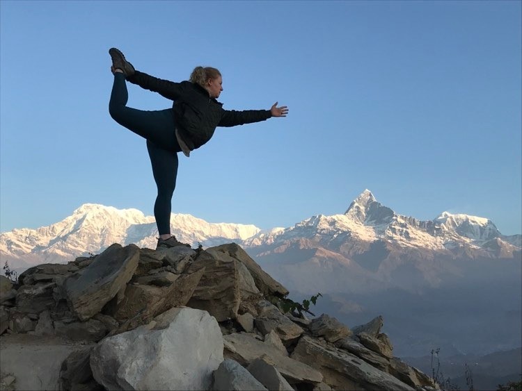
Trekkers Yoga with breathtaking Himalayan mountain views.
In fact, this variation traverses a longer ridge line with gentler ascents and descents, allowing more time to soak in the traditional Gurung villages, terraced fields, and diverse forests. You will still reach the iconic high Mardi Himal viewpoint, but with a more relaxed and comprehensive experience. The gentler start is particularly appealing to photographers and those seeking a deeper, more authentic introduction to the Annapurna region.
Dhampus Trailhead Distance Highlights :
Extended total distance: 55-64 km (34-40 miles)
Gentler approach via Pothana village
Enriched cultural experiences and longer ridge walks
More opportunities to admire rhododendron forests
Ideal for 5-6 day itineraries
Day | Section
Distance
Walking Hours | Key Features
1 | Dhampus / Phedi to Pothana
8-10 km
4-5 hrs | Village life & gentle start
2-3 | Pothana to High Camp
18-22 km
6-7 hrs/day | Extended ridge & forests
4 | Viewpoint exploration
6-8 km
4-5 hrs | High alpine panoramas
5-6 | Descent via Siding to roadhead
15-18 km
5-6 hrs | Cultural descent & finish
Total | Extended Loop
55-64 km
5-6 Days | Scenic & immersive
Extended Ridge Loop Distance Breakdown :
Here, Haven Holidays can assist you in choosing the right route variation based on your fitness level and interests.
In summary, Route Variation B, the extended ridge loop via Dhampus and Pothana, covers 55 to 64 km and offers a more extensive and culturally rewarding Mardi Himal Trek. This longer, scenic route is perfect for those wanting to immerse themselves further in the Himalayas. Contact Haven Holidays today to plan your customized Mardi Himal Trek with expert support.
Setting the Odometer: The Road Transfer Distance from Pokhara to Kande
To start your Mardi Himal Trek, you’ll be on a smooth road transfer that precisely sets the odometer before you even set foot on the trail. The journey from Pokhara Lakeside to the Kande trailhead covers 27 km (16.7 miles) and typically takes about 1 hour by private vehicle or taxi. This convenient transfer from the Lakeside to the start of the trek allows you to rest, soak in the lovely countryside, and clear your head while leaving the bustle of Lakeside behind.
Actually, Kande is one of the most convenient starting points for the Mardi Himal Trek because of its direct access to the ridge system. This short transfer conserves your energy for the trek ahead, making for a pleasant start to your journey.
Here, Haven Holidays can arrange a private transfer with an experienced driver, ensuring you arrive at the trailhead rested and ready to trek.
Pokhara to Kande Drive Highlights :
Short, picturesque 27 km (16.7 miles) road transfer
Takes around 1 hour
Direct and comfortable lakeside to mountain access
Efficient trailhead at Kande (elevation: 1,520 m / 4,987 ft)
Great opportunity to have a briefing with your guide and check equipment
Stage
Distance
Duration | Purpose
Pokhara Lakeside to Kande
27 km (16.7 miles)
1 hour | Road transfer and preparation
Kande Trailhead
Trekking begins
N/A | Official start of your foot mileage
Initial Logistics Overview :
To summarize, the Pokhara to Kande drive sets a relaxed and efficient tone for your Mardi Himal Trek. This short transfer allows you to head directly for the trail without wasting time or energy. Reach out to Haven Holidays for comfortable transportation and your all-inclusive Mardi Himal Trek package. (345 words)
The First Leg: Tracking the Distance from Kande to Australian Camp and Pothana
Here, your actual trek begins with a short yet steep uphill journey from Kande to Australian Camp and then on to Pothana. This initial stretch gives you your first taste of Mardi Himal trekking terrain with its characteristic stone stairs and forest paths. The first section involves a 2 km (1.2 miles) climb up stone steps to Australian Camp, followed by an easy 2 km walk to the ACAP checkpoint in Pothana, situated at 1,890 meters (6,201 feet).
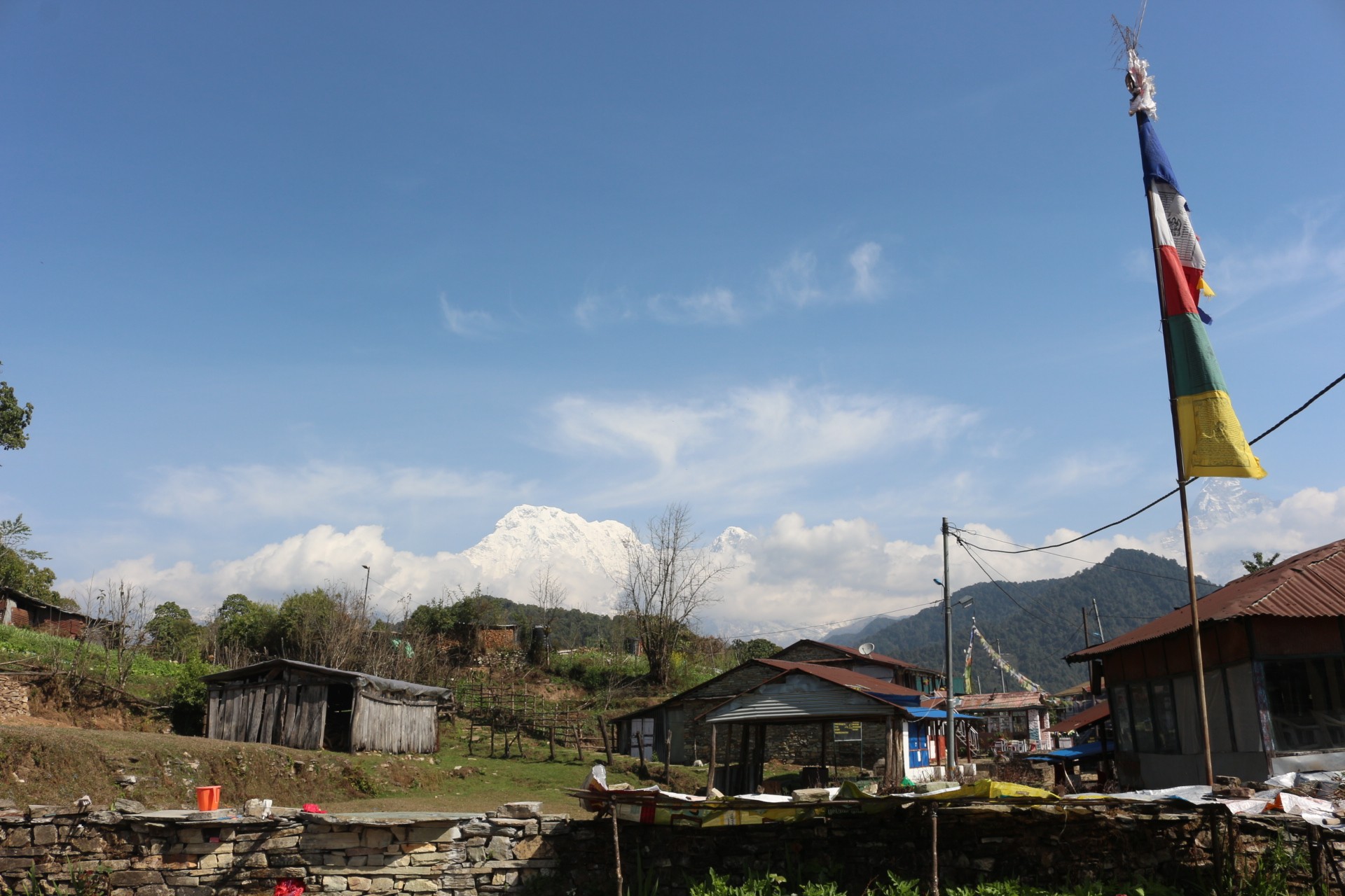
Pothana – a charming mountain village and gateway to the Mardi Himal Trek.
Likewise, you’ll be trekking through rhododendron and oak forests, getting your first views of the surrounding hills and distant peaks. Although this segment isn't long, the steep climb immediately works your legs and builds anticipation for the higher ridges to come. Australian Camp itself is a wonderful place for views and a short break before continuing to Pothana.
Kande to Pothana Distance Highlights :
Kande to Australian Camp: 2 km (1.2 miles) steep stone steps
Australian Camp to Pothana: 2 km relatively flat forest trail
Total for the first leg: 4 km (2.5 miles)
Initial upward climb through dense forest
ACAP checkpoint in Pothana (1,890 m / 6,201 ft)
Segment
Distance | Elevation Gain
Walking Time | Key Features
Kande to Australian Camp
2 km (1.2 miles) | Significant stair climb
1.5-2 hours | Steep ascent, viewpoint.
Australian Camp to Pothana
2 km | Moderate incline
1-1.5 hours | Forest trail, ACAP checkpoint .
First Day Total
4 km (2.5 miles) | Initial vertical incline
2.5-3.5 hours | Gentle warm-up for ridge days.
First Leg Distance Profile :
Here, this relatively short but engaging first leg of your trek serves as the perfect warm-up for the more challenging ridge walking to come. Haven Holidays guides will ensure you maintain a comfortable pace, allowing you to truly enjoy the scenery from the very start.
In conclusion, the initial trek from Kande to Australian Camp and Pothana provides a wonderful introduction to the Mardi Himal Trek with manageable distances and beautiful forest scenery. Contact Haven Holidays today for expert guidance and your perfect Mardi Himal Trek experience.
The Jungle Passage of No Return: Trekking from Pothana/Deurali to Forest Camp
Once you've navigated through Pritam Deurali, your hiking experience will change dramatically from the more well-trodden trails of Annapurna. This section will plunge you deep into the wilderness, where you'll leave behind the teahouse rows for the damp, mossy interior of the forest. You'll ascend along the Mardi Himal ridge, traversing a lush canopy of ancient trees.
[Forest Camp (Kokar) Lodge Hub: 2,520 m]- (+420 m Climb along desolate ridge)- [11.0 km / 6.8 mi Jungle Corridor]
[Pritam Deurali Trail Junction: 2,100 m]
Prepare for a sustained climb over a long and peaceful stretch. The trek from Deurali to Forest Camp distance km miles is an undulating 11 kilometers (6.8 miles). As this is a genuine wilderness ridge path, there are no inhabited settlements on this route. Be sure to pack sufficient water and snacks, as this is a substantial trek through the trees.
Trekking through the Forest Spine :
The Wilderness Switch: After passing the prohibited area entrance at Deurali, the broad stone staircases disappear, giving way to a narrow dirt singletrack that meanders along the top of the densely forested ridge.
The Ancient Forest Canopy: While hiking this rhododendron forest trail length, you'll be surrounded by old trees draped with moss, bamboo groves, and mountain oak trees that form a dense canopy and block out the sun.
The Undulating Ridge Walk: Instead of a direct climb, the path alternates between short, steep ascents and quick descents, challenging your leg muscles throughout the afternoon.
The Kokar Sanctuary: The trek through the long forest ends at Forest Camp (also known as Kokar) at 2,520 meters (8,267 feet), a small clearing where a few modest lodges offer you a place to relax for the night.
Ridge Trail Station Node
Elevation Metric | Section Distance Track
Est. Walking Duration | Primary Forest Environment
Pritam Deurali Base
2,100 m / 6,889 ft | 0.0 km / 0.0 mi
Departure | Open clearings with terraced farmland and edges of sub-tropical oak trees.
Humu Forest Clearing
2,380 m / 7,808 ft | 6.0 km / 3.7 mi
2.5 - 3 Hours | Thick stands of bamboo and damp soil tracks covered in moss.
Emerging from the Canopy: Ridge Walking from Forest Camp to Low and High Camp
Meanwhile, this is a visually spectacular transition from the thick jungle to the open ridges of the higher mountains. As you ascend, the forest thins and you'll find yourself with a sweeping vista of the surrounding peaks, which will guide you toward the high alpine landscape.
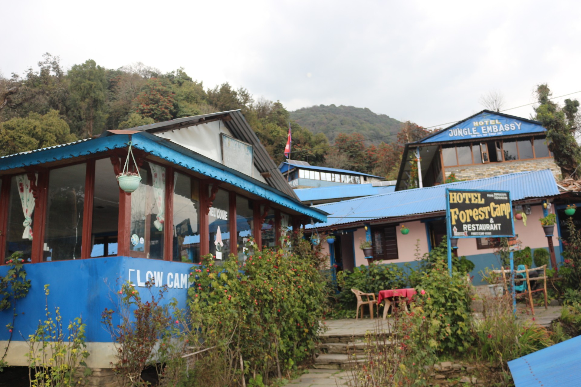
Forest Camp – a tranquil stop deep within the lush forests of the Mardi Himal trail.
[High Camp Alpine Hub: 3,550 m]- (+580 m Climb | 5.0 km / 3.1 mi)
[Badal Danda Ridge: 3,210 m]- (+450 m Climb | 4.0 km / 2.5 mi)
[Low Camp Forest Edge: 2,970 m]
[Forest Camp Base Inlet: 2,520 m]
Actually, the climb is divided into two stages that evolve in character with your increasing altitude. First, a steep 4 kilometer (2.5 miles) Forest Camp to Low Camp distance trek will bring you through the higher tree line to an elevation of 2,970 meters. Next, a magnificent 5 kilometer (3.1 miles) Low Camp to High Camp km open-ridge path will take you through the clouds at Badal Danda to High Camp at 3,550 meters (11,646 feet).
Climbing the Ridge Line :
The Low Camp Step: You'll start your morning with a steep trek through a forest covered in moss where the rhododendron trees become progressively shorter and more gnarled as you climb.
The Tree Line Threshold: When you cross the tree line threshold mileage around Badal Danda, you'll leave the forest completely and emerge onto a grassy alpine ridge.
The Cloud Ridge Walk: You'll hike along the top of the narrow ridge, where clouds often drift up from the valleys below, making for a dramatic experience.
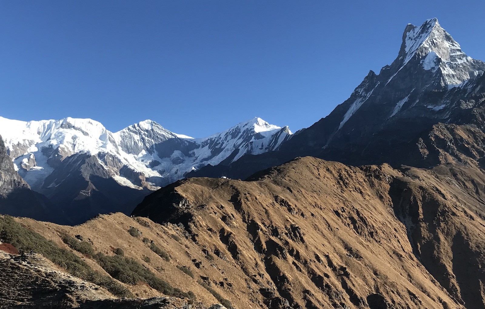
The Mountain Backdrop: From this open ridge, you'll have expansive views of the mountains-the steep south face of Annapurna South to your left and the iconic Machhapuchhre directly in front.
Alpine Ridge Checkpoint
Target Elevation | Cumulative Distance
Section Duration | Landscape & Visual Exposure
Forest Camp Base
2,520 m / 8,267 ft | 0.0 km / 0.0 mi
Departure | Dense jungle singletracks with soft, dark soil footing.
Low Camp Outpost
2,970 m / 9,744 ft | 4.0 km / 2.5 mi
2.5 - 3 Hours | Edges of the cloud forest with thin trees and mossy stone steps.
Badal Danda Crest
3,210 m / 10,531 ft | 6.5 km / 4.0 mi
1.5 - 2 Hours | Open alpine ridge meadows with distant mountain panoramas.
High Camp Hub
3,550 m / 11,646 ft | 9.0 km / 5.6 mi
1.5 - 2 Hours | Stark, windswept rock ridges below the summit of Machhapuchhre.
Elevation Profile: Upper Ridge Ascent to High Camp
The Triumphant Final Stretch: High Camp to Mardi Himal Viewpoint and Base Camp
Meanwhile, this is the peak of the entire journey; leaving High Camp before dawn, you walk along a narrow ridge to the highest points of the protected area. As you leave the teahouses at High Camp, a steep and windy trail balances precariously on a narrow mountain spine. At this point the trekking journey morphs into a high-altitude mountain trek, and your efforts are richly rewarded with unparalleled, close-up views of the enormous peaks.
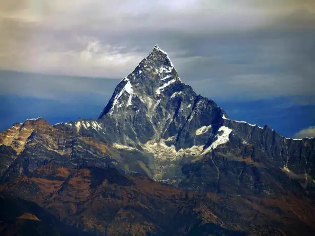
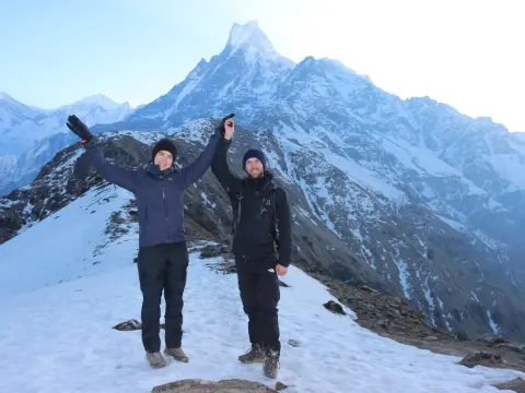
Mardi Himal Viewpoint – one of Nepal’s finest panoramas of Mt. Fishtail and the Annapurna range.
[Mardi Himal Base Camp Apex: 4,500 m]- (Rugged Glacial Terrain)
Here, this final ascent requires a high amount of effort for a relatively short distance, due to high altitude and precipitous drop-offs. The High Camp to Mardi Himal Base Camp distance is 9.0 km (5.6 mi) and traverses the barren mountainscapes of a glacial terrain. If you turn around after the primary Upper Viewpoint, the viewpoint trail length miles is 7.0 km (4.3 mi) round-trip, so it is perfectly suitable for the trekker wanting a less demanding day.
Reaching the Absolute Apex :
The Starlight Ascent: 4am start under headlamp, you follow a narrow path up the ridge. As the temperature and wind drops below freezing, dress in windproof layers and carry thermos flasks.
The Crest Viewpoint: Arriving at the 4,200 m (13,779 ft) Upper Viewpoint just as the sun rises to find yourself viewing the Annapurna Sanctuary back-lighting the face of the 6,993m peak of Machhapuchhre.
The Glacial Ridge Track: From the viewpoint you have to climb to the absolute apex mileage at the Mardi Base Camp along a rocky, glacier covered mountain track composed of loose shale and sheer steps formed out of rock.
The Base Camp Sanctuary: Mardi Himal Base Camp sits at 4,500 m (14,763 ft), right below the southwest ridge of Machhapuchhre's peak, surrounded by vertical rock faces and steep glacial valleys.
Ridge Station Node
Target Elevation | Vertical Elevation Gain
Technical Footing Type | Oxygen Level Metric
High Camp Lodge Base
3,550 m / 11,646 ft | 0.0 m / 0.0 ft
Grassy alpine meadows and hard-packed dirt singletracks | 66% of sea level
Mardi Upper Viewpoint
4,200 m / 13,779 ft | +650 m / 2,133 ft
Steep earthen switchbacks and narrow exposed rock paths | 61% of sea level
Mardi Himal Base Camp
4,500 m / 14,763 ft | +950 m / 3,117 ft
Rugged glacial moraine, loose shale rock, and seasonal ice | 58% of sea level
The Express Downhill Run: The Steep Descent Distance from High Camp to Siding Village
Once back at High Camp and repacked, the high mountain trek is transformed into a fast trek down into the deep valley. As the main ridge is a steep and narrow track that can not be easily descended, it is typically preferable to go down an alternative trail rather than follow the same path as in the way up to Forest Camp. You will then make your way down an easy mountain path into the valleys where roads lie close by.
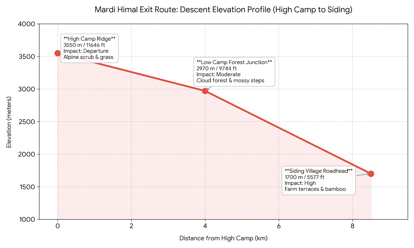
[High Camp Ridge Base: 3,550 m]-(8.5 km / 5.3 mi Continuous Knee-Pounding Descent)
[Siding Village Roadhead: 1,700 m] Fast-Track Jeep Transport to Pokhara
In fact, this descent route takes you rapidly down the mountain; the High Camp to Siding village distance goes down 1,850 vertical meters over 8.5 kilometers (5.3 miles). This steep downhill trail km leads through rhododendron and bamboo forests down to terraces at the valley floor and serves as a very quick fast-track return route saving you one day of trekking.
The express downhill run from High Camp to Siding Village – a long descent through forests, ridges, and mountain villages.
Dropping Off the Ridge Line :
The Low Camp Trail Split: From the teahouses, you can rejoin the High Camp ridge trail or start the dramatic descent of the mountain at the split trail, which begins past Low Camp.
The Forest Descent: The trail immediately winds down through thick rhodo and bamboo forest where muddy steps built into the hillside have been made slippery by fallen leaves and roots.
The Terraced Farmlands: The last half of this descent passes through typical Gurung and Brahmin villages with fields cultivated with millet and mustard flowers.
The Siding Roadhead Junction: You arrive in Siding Village (1,700m / 5,577ft), where there are options for transport back to Pokhara, or another night of stay before catching a jeep in the morning.
Exit Route Station
Elevation Metric | Section Distance Track
Estimated Knee Impact | Primary Vegetation Zone
High Camp Ridge
3,550 m / 11,646 ft | 0.0 km / 0.0 mi
Departure | Stark alpine scrub and windswept grass pastures.
Low Camp Forest Junction
2,970 m / 9,744 ft | 4.0 km / 2.5 mi
Moderate | Dense cloud forests with mossy stone steps.
Siding Village Roadhead
1,700 m / 5,577 ft | 8.5 km / 5.3 mi
High | Sub-tropical farm terraces and bamboo groves.
Elevation Profile: High Camp to Siding Village Escape
The Meaning of Ridge Mileage: Why Horizontal Distance Fools Your Legs
Meanwhile, the five kilometers that you'll be covering each day on the trail can easily trick you into thinking it's just a brief walk in the park when looking at your map. On this particular trek, however, that standard measurement just won't do. Mardi Himal's difficulty arises from its unusual path. Instead of following a traditional, multi-day trekking route through wide river valleys, this hike is entirely built on a narrow mountain spine.
[Typical Valley Walk: Long, horizontal mileage on a river path]
[Mardi Himal Ridge Walk: Short horizontal mileage with large altitude changes]
When it comes to day-to-day travel, the numbers to keep an eye on are elevation gain versus horizontal distance. Walking directly up a ridge means you will be constantly straining your leg muscles and working hard against gravity with every single step. It’s due to this steep grade that walking 5km on the Mardi Himal hike will take twice the physical effort and endurance of walking 5km on flat ground, naturally slowing you to a walk of 1-2km per hour.
Maximizing Endurance on the spine :
Strain of a vertical ascent: Because of the tight-angled and narrow ridge path you are walking on, you will not encounter any large, flat expanses and will constantly be working your thigh and calf muscles uphill or downhill.
Protecting your joints: The extremely steep descents can place significant pressure on your knees and ankles. Make the most out of your trekking pole use here – two poles can support up to 25% of your body’s weight with every stride, and this will not only ease the load on your knees, but they'll keep you from tumbling onto tree roots and slippery rocks.
Strategy for covering ground: The easiest way to approach ridge mileage is to move at a steady pace. Make your steps small and avoid rapid, quick ascents, which will require frequent rests and fatigue your body quickly.
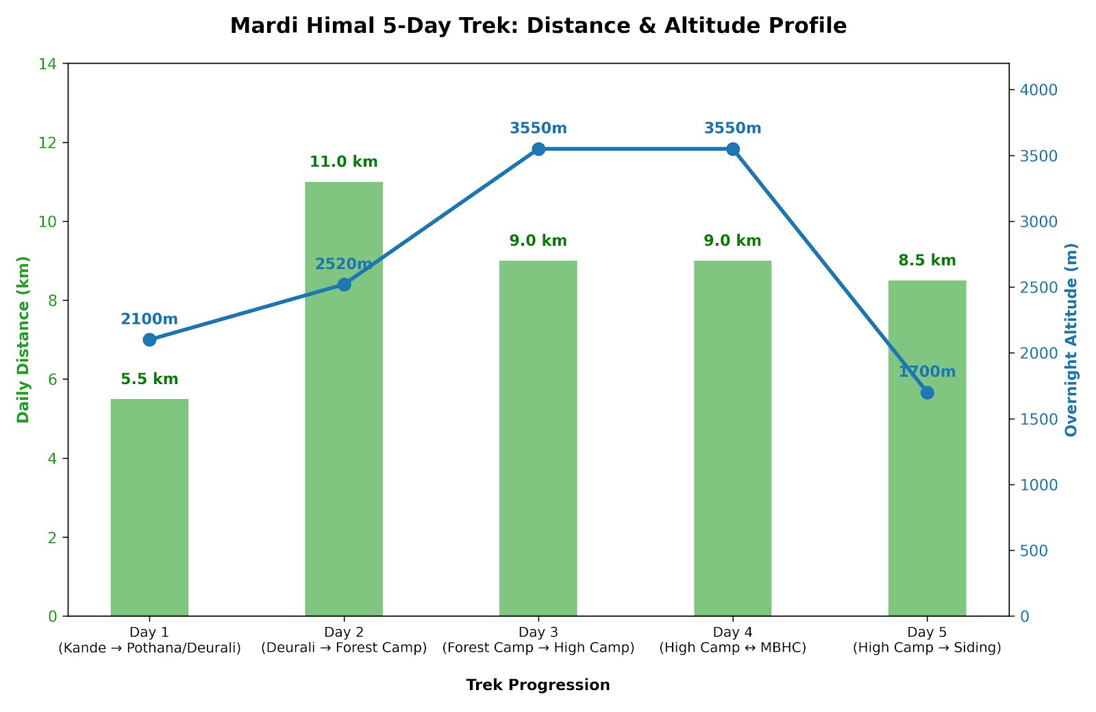
Summary: Day-by-Day distance chart and kilometer Breakdown
Here, below is a definitive Mardi Himal day-by-day distance chart that compiles the classic route information into an easily digestible, 5-day itinerary. The following route summary table details the trekking distance for each day, estimated walking times and overnight altitudes, and will serve as an excellent pocket mileage tracker for you to save and download.
Day of Trekking & Leg
Total km | Total miles
Est. Walking time | Overnight altitude | Main terrain profile.
Day 1: Kande to Pothana / Deurali
5.5 km | 3.4 miles
3-4 hrs | 2100m / 6889ft | Stones steps through Rhododendron jungle, small villages and ridgelines.
Day 2: Deurali to Forest Camp
11 km | 6.8 miles
5-6 hrs | 2520m / 8267ft | Whispering, singletrack trail, enclosed in dense jungle and running across ridge lines.
Day 3: Forest Camp to High Camp
9 km | 5.6 miles
5-6 hrs | 3550m / 11646ft | Sloping upward through a thick forest leading to alpine ridgelines.
Day 4: High Camp to Mardi Himal Base Camp & back to High Camp
9km | 5.6 miles
6-7 hours | 3550m / 11646ft | Steep, narrow paths through rugged alpine and glaciated terrain.
Day 5: High Camp to Siding Village
8.5 km | 5.3 miles
4-5 hours | 1700m / 5577ft | Continuous steep descent through cloud forest and agricultural terraces.
Mardi Himal Classic 5-day Mileage Tracker
Logistical note: The route that the distances above represent is the main and classic route only. For those hiking the true Mardi Himal Base Camp (at 4,500 meters), you will need to allow for 2 more kilometers of travel over rocky terrain. Base Camp is an option that only experienced hikers or those who reach Upper Viewpoint early will be able to take advantage of.
Mardi Himal Classic 5-Day Mileage Tracker – follow the daily distance covered on this unforgettable Himalayan adventure
1. What is the standard Mardi Himal Trek total distance covered on foot? The classic Mardi Himal Trek total distance covered on foot is approximately 41 to 45 kilometers (25 to 28 miles). This measurement is for the full loop, starting from the trailhead at Kande, trekking to Mardi Himal Base Camp, and descending via Siding village before returning to Pokhara.
2. How does the starting point affect the Mardi Himal Trek total distance? Choosing Kande as your trailhead results in the longest Mardi Himal Trek total distance, around 45 km. Starting from Phedi or Dhampus involves ascending numerous stone stairs before joining the main ridge trail, slightly altering the walking distance and daily effort.
3. What is the average daily walking distance on this itinerary? On average, trekkers cover a Mardi Himal Trek total distance of 6 to 12 kilometers per day. This typically translates to 4 to 6 hours of hiking, which is intentionally kept moderate to aid acclimatization as the altitude gains rapidly over a short span.
4. How long is the trek from Kande to Deurali on Day 1? The initial walking segment from Kande to Pitam Deurali is about 6 kilometers. This introductory hike takes approximately 4 to 5 hours to complete, passing through Australian Camp and Pothana on a gentle uphill path within forests.
5. What distance is covered from Deurali to Forest Camp? The hike from Deurali to Forest Camp (Kokar), located deep in the rhododendron jungle, covers a Mardi Himal Trek total distance of 11.5 kilometers. This quiet, off-the-beaten-path section typically takes 5 to 6 hours of continuous ridge walking.
6. What is the trail distance between Forest Camp and Low Camp? The trek from Forest Camp up to Low Camp covers a shorter distance of 6 to 7 kilometers. Despite the mileage, the trail is steep and leads through dense, moss-covered forests, taking about 4 to 5 hours to complete.
7. How far is the ridge walk from Low Camp to High Camp? The scenic trek from Low Camp to High Camp covers a distance of 7 to 8 kilometers. This section features a steady climb along an exposed ridge with diminishing tree cover, offering 360-degree mountain views and taking roughly 3 to 4 hours.
8. What is the round-trip distance from High Camp to Mardi Himal Base Camp? The demanding round trip from High Camp to the official Mardi Himal Base Camp covers a Mardi Himal Trek total distance of 10 kilometers. This section is along a narrow, exposed rocky ridge and requires 7 to 8 hours of careful hiking.
9. How long is the descent from High Camp down to Siding Village? The steep descent from High Camp to Siding Village spans approximately 8 kilometers. This part of the trek drops rapidly through the treeline and can take about 5 to 6 hours, placing considerable stress on the knees.
10. Can you complete the Mardi Himal Trek total distance in 3 days? It is possible to complete a shorter Mardi Himal Trek total distance in 3 days, but this requires using jeeps directly to Kalimati or Siding and bypassing the lower forest sections. This shortened version covers a total walking distance of about 20 km round trip from Mardi Himal Base Camp, best suited for highly fit hikers.
11. Is the Mardi Himal Trek distance considered difficult for beginners? The Mardi Himal Trek total distance is generally considered easy to moderate, making it an excellent choice for beginners. It is shorter and less physically demanding than many other Annapurna treks and does not require any technical climbing skills, only decent cardiovascular fitness.
12. What is the total elevation gain along this trekking route? While trekking the Mardi Himal Trek total distance, you ascend from an altitude of 1,770 meters in Kande to 4,500 meters at Base Camp. This represents a total vertical elevation gain of 2,730 meters over just four days of climbing.
13. Why does the final 10 km to Base Camp feel so challenging? The round-trip Mardi Himal Trek total distance to Base Camp feels particularly challenging due to the extreme altitude. At 4,500 meters, the air is thin, leading to reduced oxygen levels. This, combined with the steep, narrow ridge path, requires trekkers to proceed at a slow pace.
14. Are there milestone markers along the Mardi Himal Trek distance? Yes, the Mardi Himal Trek total distance is well-marked with color-coded trail signs and directional arrows carved into trees and rocks. Key teahouses like Forest Camp, Low Camp, and Badal Danda serve as important geographical milestones along the route.
15. Does the 5-day or 7-day itinerary change the actual walking distance? The overall Mardi Himal Trek total distance remains approximately 45 kilometers regardless of whether you choose a 5-day or 7-day itinerary. A longer itinerary simply breaks down the daily mileage into shorter, more manageable sections, providing extra rest and improving acclimatization.
16. What packaging modifications help manage the trek distance comfortably? To comfortably manage the Mardi Himal Trek total distance, it's advisable to use a local porter to carry your main rucksack (under 15 kg). Using a light daypack for essentials like water, a windcheater, and trekking poles can reduce strain, especially on steep ascents and descents.
17. Can I add the Ghandruk or Poon Hill loop to this distance? Yes, you can extend the Mardi Himal Trek total distance significantly, even exceeding 80 kilometers, by incorporating the Ghorepani Poon Hill or Landruk trails. This combination forms a larger circuit within the Annapurna Sanctuary and requires an additional 4 to 5 days of trekking.
18. How much water should I drink while covering the trail distance? While trekking the Mardi Himal Trek total distance, it's crucial to drink between 3 to 4 liters of clean water daily. Adequate hydration is vital for muscle function and serves as a primary preventive measure against Acute Mountain Sickness (AMS).
19. Does winter weather change the Mardi Himal Trek total distance? The physical Mardi Himal Trek total distance remains the same in winter, but the snow conditions can significantly impact your pace. Heavy snow above High Camp may necessitate crampons or even lead to a turnaround at the Upper Viewpoint (4,200m) for safety.
20. What is the best resource for calculating exact trail distances daily? The most accurate way to monitor the Mardi Himal Trek total distance on a daily basis is by using an offline GPS map application or hiring a licensed local guide. Guides offer real-time information on trail conditions, distance milestones, and elevation changes.