[{"name":"Everest Base Camp Helicopter Tour","duration":"1","image_url":"https:\/\/www.havenholidaysnepal.com\/storage\/trip-galleries\/1\/thumb_6cd53005d75a86e373d31419d1b14d78.webp","offer_price":1195,"url":"https:\/\/www.havenholidaysnepal.com\/trips\/everest-base-camp-helicopter-tour"},{"name":"Everest Mountain Flight","duration":"1","image_url":"https:\/\/www.havenholidaysnepal.com\/storage\/trip-galleries\/4\/thumb_3b0b4f1d6f72b0ad224daf4752f2c6e0.jpg","offer_price":285,"url":"https:\/\/www.havenholidaysnepal.com\/trips\/everest-mountain-flight"},{"name":"Everest Short Trek","duration":"9","image_url":"https:\/\/www.havenholidaysnepal.com\/storage\/trip-galleries\/5\/thumb_BXPP3621.JPEG0.02033800 1727957098.webp","offer_price":995,"url":"https:\/\/www.havenholidaysnepal.com\/trips\/everest-short-trek"},{"name":"Gokyo Valley Trek","duration":"12","image_url":"https:\/\/www.havenholidaysnepal.com\/storage\/trip-galleries\/6\/thumb_10bc469b14731f23d3ce84a7092ad53f.jpg","offer_price":1195,"url":"https:\/\/www.havenholidaysnepal.com\/trips\/gokyo-valley-trek"},{"name":"15 days Annapurna Base Camp Trek","duration":"15","image_url":"https:\/\/www.havenholidaysnepal.com\/storage\/trip-galleries\/7\/thumb_87d1533bc45faf070990aef0579e4be4.jpg0.81855100 1728285496.webp","offer_price":785,"url":"https:\/\/www.havenholidaysnepal.com\/trips\/15-days-annapurna-base-camp-trek"},{"name":"Nepal Pilgrimage Tour","duration":"14","image_url":"https:\/\/www.havenholidaysnepal.com\/storage\/trip-galleries\/8\/thumb_02c3bcf2ad2e8a4c1703e90ae747b5f1.jpg","offer_price":1475,"url":"https:\/\/www.havenholidaysnepal.com\/trips\/nepal-pilgrimage-tour"},{"name":"UNESCO World Heritage Site Tour","duration":"10","image_url":"https:\/\/www.havenholidaysnepal.com\/storage\/trip-galleries\/9\/thumb_unesco-world-heritage-site-Lumbani-temple-buddhists-hindus-kathmandu-nepal0.36988600 17347617740.93089500 1737469667.webp","offer_price":715,"url":"https:\/\/www.havenholidaysnepal.com\/trips\/unesco-world-heritage-site-tour"},{"name":"Island Peak Climbing","duration":"16","image_url":"https:\/\/www.havenholidaysnepal.com\/storage\/trip-galleries\/11\/thumb_Island peak0.53947000 1734692503.webp","offer_price":2495,"url":"https:\/\/www.havenholidaysnepal.com\/trips\/island-peak-climbing"},{"name":"Upper Mustang Trek","duration":"18","image_url":"https:\/\/www.havenholidaysnepal.com\/storage\/trip-galleries\/12\/thumb_upper mustang 7 Oct-2024.jpg0.95398900 1728286166.webp","offer_price":2995,"url":"https:\/\/www.havenholidaysnepal.com\/trips\/upper-mustang-trek"},{"name":"Annapurna Circuit Trek","duration":"16","image_url":"https:\/\/www.havenholidaysnepal.com\/storage\/trip-galleries\/15\/thumb_tibetan-flags.jpg0.04843900 1728289138.webp","offer_price":985,"url":"https:\/\/www.havenholidaysnepal.com\/trips\/annapurna-circuit-trek"},{"name":"Gosainkunda Lake Trek","duration":"10","image_url":"https:\/\/www.havenholidaysnepal.com\/storage\/trip-galleries\/16\/thumb_5A8083B3-C007-41A8-853F-D0C37C97D235_1_105_c.jpeg0.52581200 1731845258.webp","offer_price":595,"url":"https:\/\/www.havenholidaysnepal.com\/trips\/gosainkunda-lake-trek"},{"name":"Zip-lining in Pokhara and Dhulikhel","duration":"1","image_url":"https:\/\/www.havenholidaysnepal.com\/storage\/trip-galleries\/18\/thumb_215f765e2ebc995dd5c800b4bfdbacc3.jpg","offer_price":82,"url":"https:\/\/www.havenholidaysnepal.com\/trips\/zip-lining-in-pokhara-and-dhulikhel"},{"name":"Annapurna Heli Tour","duration":"1","image_url":"https:\/\/www.havenholidaysnepal.com\/storage\/trip-galleries\/19\/thumb_d71a6bbb9fd4da8d1b567a5cdbdec85d.jpg","offer_price":555,"url":"https:\/\/www.havenholidaysnepal.com\/trips\/annapurna-heli-tour"},{"name":"Paragliding in Pokhara","duration":"1","image_url":"https:\/\/www.havenholidaysnepal.com\/storage\/trip-galleries\/20\/thumb_de788d2dd9726783431f882c007efae1.jpg","offer_price":65,"url":"https:\/\/www.havenholidaysnepal.com\/trips\/paragliding-in-pokhara"},{"name":"Ultra-Flight in Pokhara","duration":"1","image_url":"https:\/\/www.havenholidaysnepal.com\/storage\/trip-galleries\/21\/thumb_e27a9fb572a5c21611bb2a3c18e4b8f0.jpeg","offer_price":175,"url":"https:\/\/www.havenholidaysnepal.com\/trips\/ultra-flight-in-pokhara"},{"name":"Sarangkot Hiking","duration":"1","image_url":"https:\/\/www.havenholidaysnepal.com\/storage\/trip-galleries\/22\/thumb_100ef822fea19987166c6c1366215f15.jpg","offer_price":55,"url":"https:\/\/www.havenholidaysnepal.com\/trips\/sarangkot-hiking"},{"name":"Mera Peak Climbing","duration":"18","image_url":"https:\/\/www.havenholidaysnepal.com\/storage\/trip-galleries\/24\/thumb_d16ae3895f678cf26ffbf2455f541fb5.jpg0.31883400 1732617790.webp","offer_price":2475,"url":"https:\/\/www.havenholidaysnepal.com\/trips\/mera-peak-climbing"},{"name":"Lower Dolpo Trek","duration":"18","image_url":"https:\/\/www.havenholidaysnepal.com\/storage\/trip-galleries\/26\/thumb_Dolpo Galary - 1.JPG0.37725200 1727939952.webp","offer_price":2995,"url":"https:\/\/www.havenholidaysnepal.com\/trips\/lower-dolpo-trek"},{"name":"Nagarkot Sunrise\/Sunset Tour","duration":"1","image_url":"https:\/\/www.havenholidaysnepal.com\/storage\/trip-galleries\/27\/thumb_5147a5532644283a380f2e86f3857c13.jpg0.17748000 1728488108.webp","offer_price":30,"url":"https:\/\/www.havenholidaysnepal.com\/trips\/nagarkot-sunrise-sunset-tour"},{"name":"16 day Everest Base Camp Trek","duration":"16","image_url":"https:\/\/www.havenholidaysnepal.com\/storage\/trip-galleries\/28\/thumb_IMG_4311.JPG0.64984800 1727942213.webp","offer_price":1475,"url":"https:\/\/www.havenholidaysnepal.com\/trips\/16-day-everest-base-camp-trek"},{"name":"Ghorepani Poon Hill trek with Jungle Safari and Trishuli River Rafting -13 days","duration":"13","image_url":"https:\/\/www.havenholidaysnepal.com\/storage\/trip-galleries\/29\/thumb_Ghorepani Poon hill.jpg0.48460800 1728281439.webp","offer_price":795,"url":"https:\/\/www.havenholidaysnepal.com\/trips\/ghorepani-poon-hill-trek-with-jungle-safari-and-trishuli-river-rafting--13-days"},{"name":"Mardi Himal Trek","duration":"12","image_url":"https:\/\/www.havenholidaysnepal.com\/storage\/trip-galleries\/30\/thumb_s1.jpg0.62112600 1728200721.webp","offer_price":795,"url":"https:\/\/www.havenholidaysnepal.com\/trips\/mardi-himal-trek"},{"name":"Langtang Valley Trekking","duration":"10","image_url":"https:\/\/www.havenholidaysnepal.com\/storage\/trip-galleries\/31\/thumb_IMG_4702.JPG0.84916500 1727958504.webp","offer_price":685,"url":"https:\/\/www.havenholidaysnepal.com\/trips\/langtang-valley-trekking"},{"name":"Real Adventure Tour in Nepal","duration":"9","image_url":"https:\/\/www.havenholidaysnepal.com\/storage\/trip-galleries\/32\/thumb_ebd1b8cc78d90abe8b9003dd9a2f25bf.jpg0.82151300 1728213516.webp","offer_price":695,"url":"https:\/\/www.havenholidaysnepal.com\/trips\/real-adventure-tour-in-nepal"},{"name":"Luxury Tour in Nepal","duration":"10","image_url":"https:\/\/www.havenholidaysnepal.com\/storage\/trip-galleries\/33\/thumb_8574e61b252b18676b042caf30d830df.jpg","offer_price":1675,"url":"https:\/\/www.havenholidaysnepal.com\/trips\/luxury-tour-in-nepal"},{"name":"Luxury Everest Panorama Trek With EBC Heli Sightseeing","duration":"8","image_url":"https:\/\/www.havenholidaysnepal.com\/storage\/trip-galleries\/34\/thumb_URZL2397.JPEG0.01209600 1728027820.webp","offer_price":2575,"url":"https:\/\/www.havenholidaysnepal.com\/trips\/luxury-everest-panorama-trek-with-ebc-heli-sightseeing"},{"name":"13 day Everest Base Camp Trek with Helicopter","duration":"13","image_url":"https:\/\/www.havenholidaysnepal.com\/storage\/trip-galleries\/35\/thumb_IMG_4292.JPG0.70131500 1728029276.webp","offer_price":2095,"url":"https:\/\/www.havenholidaysnepal.com\/trips\/13-day-everest-base-camp-trek-with-helicopter"},{"name":"Manaslu Circuit Trek","duration":"16","image_url":"https:\/\/www.havenholidaysnepal.com\/storage\/trip-galleries\/36\/thumb_Mt Manaslu 03-Oct-2024.jpg0.65804900 1727938470.webp","offer_price":955,"url":"https:\/\/www.havenholidaysnepal.com\/trips\/manaslu-circuit-trek"},{"name":"Kanchenjunga Base Camp Trek","duration":"21","image_url":"https:\/\/www.havenholidaysnepal.com\/storage\/trip-galleries\/37\/thumb_Kanchanjunga Trek -!.jpg0.54744400 1727938497.webp","offer_price":2275,"url":"https:\/\/www.havenholidaysnepal.com\/trips\/kanchenjunga-base-camp-trek"},{"name":"Ganesh Himal and Sing-La Trek","duration":"18","image_url":"https:\/\/www.havenholidaysnepal.com\/storage\/trip-galleries\/38\/thumb_Ganesh Himal slider-1.jpg0.43764500 1727937722.webp","offer_price":2975,"url":"https:\/\/www.havenholidaysnepal.com\/trips\/ganesh-himal-and-sing-la-trek"},{"name":"Island Peak Climb with Everest Base Camp Trek","duration":"21","image_url":"https:\/\/www.havenholidaysnepal.com\/storage\/trip-galleries\/39\/thumb_2be428730fe83525bc85a010564f99de.jpg","offer_price":2750,"url":"https:\/\/www.havenholidaysnepal.com\/trips\/island-peak-climb-with-everest-base-camp-trek"},{"name":"Students' Adventure Tour in Nepal","duration":"12","image_url":"https:\/\/www.havenholidaysnepal.com\/storage\/trip-galleries\/41\/thumb_a926d22fbfe08cba271c41ac289b3fd2.jpg","offer_price":995,"url":"https:\/\/www.havenholidaysnepal.com\/trips\/students-adventure-tour-in-nepal"},{"name":"7 Day Poonhill Trek","duration":"7","image_url":"https:\/\/www.havenholidaysnepal.com\/storage\/trip-galleries\/42\/thumb_6196bd69036473293a2c24cc21ed57d7.jpg0.10880600 1728205378.webp","offer_price":555,"url":"https:\/\/www.havenholidaysnepal.com\/trips\/7-day-poonhill-trek"},{"name":"7 Days Annapurna Base Camp Trek","duration":"7","image_url":"https:\/\/www.havenholidaysnepal.com\/storage\/trip-galleries\/43\/thumb_IMG_2214.JPG0.08204900 1728202033.webp","offer_price":355,"url":"https:\/\/www.havenholidaysnepal.com\/trips\/7-days-annapurna-base-camp-trek"},{"name":"3 days Poonhill Trek","duration":"3","image_url":"https:\/\/www.havenholidaysnepal.com\/storage\/trip-galleries\/44\/thumb_Poon hill.jpg0.60816600 1731412954.webp","offer_price":165,"url":"https:\/\/www.havenholidaysnepal.com\/trips\/3-days-poonhill-trek"},{"name":"Poon Hill Luxury Trek with Chitwan-12 days","duration":"12","image_url":"https:\/\/www.havenholidaysnepal.com\/storage\/trip-galleries\/45\/thumb_Poom hill.jpg0.52074500 1730180532.webp","offer_price":1175,"url":"https:\/\/www.havenholidaysnepal.com\/trips\/poon-hill-luxury-trek-with-chitwan-12-days"},{"name":"Everest Luxury Trek-7 days","duration":"7","image_url":"https:\/\/www.havenholidaysnepal.com\/storage\/trip-galleries\/46\/thumb_ACRX9330.JPEG0.93236200 1728031275.webp","offer_price":1975,"url":"https:\/\/www.havenholidaysnepal.com\/trips\/everest-luxury-trek-7-days"},{"name":"Hindu Pilgrimage Tour in Nepal-10 days","duration":"10","image_url":"https:\/\/www.havenholidaysnepal.com\/storage\/trip-galleries\/47\/thumb_a94bf96a4d31decb419f6f828a3280d2.jpg","offer_price":995,"url":"https:\/\/www.havenholidaysnepal.com\/trips\/hindu-pilgrimage-tour-in-nepal-10-days"},{"name":"Everest Base Camp Short Trek-12 days","duration":"12","image_url":"https:\/\/www.havenholidaysnepal.com\/storage\/trip-galleries\/48\/thumb_IMG_4311.JPG0.52680100 1727945154.webp","offer_price":995,"url":"https:\/\/www.havenholidaysnepal.com\/trips\/everest-base-camp-short-trek-12-days"},{"name":"Everest Base Camp Hike 12 Days","duration":"12","image_url":"https:\/\/www.havenholidaysnepal.com\/storage\/trip-galleries\/49\/thumb_IMG_4260.JPG0.51729100 1728061234.webp","offer_price":1295,"url":"https:\/\/www.havenholidaysnepal.com\/trips\/everest-base-camp-hike-12-days"},{"name":"11 Days Everest Base Camp Trek","duration":"11","image_url":"https:\/\/www.havenholidaysnepal.com\/storage\/trip-galleries\/50\/thumb_IMG_4249.JPG0.21392500 1727946959.webp","offer_price":985,"url":"https:\/\/www.havenholidaysnepal.com\/trips\/11-days-everest-base-camp-trek"},{"name":"6 Days Annapurna Base Camp Trek","duration":"6","image_url":"https:\/\/www.havenholidaysnepal.com\/storage\/trip-galleries\/51\/thumb_6 days Abc.jpg0.58185400 1728200798.webp","offer_price":285,"url":"https:\/\/www.havenholidaysnepal.com\/trips\/6-days-annapurna-base-camp-trek"},{"name":"Annapurna Base Camp Trek","duration":"8","image_url":"https:\/\/www.havenholidaysnepal.com\/storage\/trip-galleries\/52\/thumb_IMG_2214.JPG0.29415700 1729487656.webp","offer_price":585,"url":"https:\/\/www.havenholidaysnepal.com\/trips\/annapurna-base-camp-trek"},{"name":"Everest Base Camp Trek with Helicopter Fly Out 10 Days","duration":"10","image_url":"https:\/\/www.havenholidaysnepal.com\/storage\/trip-galleries\/53\/thumb_IMG_4328.JPG0.52056600 1728058444.webp","offer_price":1875,"url":"https:\/\/www.havenholidaysnepal.com\/trips\/everest-base-camp-trek-with-helicopter-fly-out-10-days"},{"name":"Everest Base Camp Trek 14 Days","duration":"14","image_url":"https:\/\/www.havenholidaysnepal.com\/storage\/trip-galleries\/54\/thumb_Everest Base Camp Trek 14 days Oct 3 2024.JPG0.43202700 1727939745.webp","offer_price":1455,"url":"https:\/\/www.havenholidaysnepal.com\/trips\/everest-base-camp-trek-14-days"},{"name":"ABC Trek with Poonhill 11 Days","duration":"11","image_url":"https:\/\/www.havenholidaysnepal.com\/storage\/trip-galleries\/55\/thumb_ABC with fishtail.JPG0.21441100 1728277965.webp","offer_price":555,"url":"https:\/\/www.havenholidaysnepal.com\/trips\/abc-trek-with-poonhill-11-days"},{"name":"Muldai Hill Trek 9 Days","duration":"9","image_url":"https:\/\/www.havenholidaysnepal.com\/storage\/trip-galleries\/56\/thumb_7efee59f0a8c6817c8255bd2b9f3539d.jpeg0.19479300 1728213091.webp","offer_price":675,"url":"https:\/\/www.havenholidaysnepal.com\/trips\/muldai-hill-trek-9-days"},{"name":"Mardi Himal Trek 6 days","duration":"6","image_url":"https:\/\/www.havenholidaysnepal.com\/storage\/trip-galleries\/57\/thumb_slider 1.jpeg0.36909700 1728184981.webp","offer_price":590,"url":"https:\/\/www.havenholidaysnepal.com\/trips\/mardi-himal-trek-6-days"},{"name":"Mardi Himal Trek 7 days","duration":"7","image_url":"https:\/\/www.havenholidaysnepal.com\/storage\/trip-galleries\/58\/thumb_slider1.jpg0.61666600 1728206414.webp","offer_price":620,"url":"https:\/\/www.havenholidaysnepal.com\/trips\/mardi-himal-trek-7-days"},{"name":"Mardi Himal Trek 8 Days","duration":"8","image_url":"https:\/\/www.havenholidaysnepal.com\/storage\/trip-galleries\/59\/thumb_sli1.jpg0.38569100 1728206631.webp","offer_price":695,"url":"https:\/\/www.havenholidaysnepal.com\/trips\/mardi-himal-trek-8-days"},{"name":"14 Days Manaslu Trek","duration":"14","image_url":"https:\/\/www.havenholidaysnepal.com\/storage\/trip-galleries\/60\/thumb_sunrise-mt-manaslu-during-manaslu-circuit-larke-pass-trekking-himalaya-nepal (1)0.81855800 1738673284.webp","offer_price":885,"url":"https:\/\/www.havenholidaysnepal.com\/trips\/14-days-manaslu-trek"},{"name":"Dhampus-Sarangkot Trek with Chitwan 8 days","duration":"8","image_url":"https:\/\/www.havenholidaysnepal.com\/storage\/trip-galleries\/61\/thumb_Sarangkot Bhangyang.jpg0.75461400 1728210333.webp","offer_price":790,"url":"https:\/\/www.havenholidaysnepal.com\/trips\/dhampus-sarangkot-trek-with-chitwan-8-days"},{"name":"7 Days Golden Triangle Tour","duration":"7","image_url":"https:\/\/www.havenholidaysnepal.com\/storage\/trip-galleries\/62\/thumb_311ce1d117ee0ba75402a7c301bcdf830.73532400 1739179809.webp","offer_price":845,"url":"https:\/\/www.havenholidaysnepal.com\/trips\/7-days-golden-triangle-tour"},{"name":"Annapurna Circuit Trek 12 days","duration":"12","image_url":"https:\/\/www.havenholidaysnepal.com\/storage\/trip-galleries\/63\/thumb_IMG_20161024_092237.jpg0.57796600 1728289938.webp","offer_price":695,"url":"https:\/\/www.havenholidaysnepal.com\/trips\/annapurna-circuit-trek-12-days"},{"name":"Everest Base Camp Budget Trek 16 Days","duration":"16","image_url":"https:\/\/www.havenholidaysnepal.com\/storage\/trip-galleries\/64\/thumb_IMG_4423.JPG0.92579200 1728144669.webp","offer_price":958,"url":"https:\/\/www.havenholidaysnepal.com\/trips\/everest-base-camp-budget-trek-16-days"},{"name":"Poonhill Budget Trek 7 Days","duration":"7","image_url":"https:\/\/www.havenholidaysnepal.com\/storage\/trip-galleries\/65\/thumb_5be067852d0c5228d6f3155bc425c6b5.jpg","offer_price":395,"url":"https:\/\/www.havenholidaysnepal.com\/trips\/poonhill-budget-trek-7-days"},{"name":"Annapurna Base Camp Budget Trek 8 Days","duration":"8","image_url":"https:\/\/www.havenholidaysnepal.com\/storage\/trip-galleries\/66\/thumb_Pokhara.jpg0.16188000 1728212001.webp","offer_price":375,"url":"https:\/\/www.havenholidaysnepal.com\/trips\/annapurna-base-camp-budget-trek-8-days"},{"name":"The Real UNESCO Seven World Heritage Tour in Kathmandu 4 days","duration":"4","image_url":"https:\/\/www.havenholidaysnepal.com\/storage\/trip-galleries\/67\/thumb_Baudha Stupa.JPG0.63906900 1728201021.webp","offer_price":380,"url":"https:\/\/www.havenholidaysnepal.com\/trips\/the-real-unesco-seven-world-heritage-tour-in-kathmandu-4-days"},{"name":"Everest Base Camp Jeep Ride with Helicopter Return","duration":"14","image_url":"https:\/\/www.havenholidaysnepal.com\/storage\/trip-galleries\/68\/thumb_788ee5b63a6efb6f3c3d048b4270daca.JPG","offer_price":1895,"url":"https:\/\/www.havenholidaysnepal.com\/trips\/everest-base-camp-jeep-ride-with-helicopter-return"},{"name":"Annapurna Base Camp Jeep Ride with Helicopter Return 7 days","duration":"7","image_url":"https:\/\/www.havenholidaysnepal.com\/storage\/trip-galleries\/69\/thumb_abc jeep.jpg0.10280600 1728204064.webp","offer_price":1455,"url":"https:\/\/www.havenholidaysnepal.com\/trips\/annapurna-base-camp-jeep-ride-with-helicopter-return-7-days"},{"name":"Everest Base Camp Trek","duration":"15","image_url":"https:\/\/www.havenholidaysnepal.com\/storage\/trip-galleries\/70\/thumb_Everest Base Camp Trek 3 oct- 2024.JPG0.58445300 1727941472.webp","offer_price":1575,"url":"https:\/\/www.havenholidaysnepal.com\/trips\/everest-base-camp-trek"},{"name":"7 UNESCO World Heritage Tour Kathmandu 2 days","duration":"2","image_url":"https:\/\/www.havenholidaysnepal.com\/storage\/trip-galleries\/72\/thumb_Bhaktipur 3.jpg0.05559600 1728201496.webp","offer_price":150,"url":"https:\/\/www.havenholidaysnepal.com\/trips\/7-unesco-world-heritage-tour-kathmandu-2-days"},{"name":"Day Tour to UNESCO Heritage Sites","duration":"1","image_url":"https:\/\/www.havenholidaysnepal.com\/storage\/trip-galleries\/73\/thumb_228A1018.jpg0.79892500 1728199793.webp","offer_price":55,"url":"https:\/\/www.havenholidaysnepal.com\/trips\/day-tour-to-unesco-heritage-sites"},{"name":"Golden Triangle Tour in Nepal","duration":"8","image_url":"https:\/\/www.havenholidaysnepal.com\/storage\/trip-galleries\/74\/thumb_f54139cf9100f00015ffe0400687e946.webp","offer_price":588,"url":"https:\/\/www.havenholidaysnepal.com\/trips\/golden-triangle-tour-in-nepal"},{"name":"Everest Base Camp Honeymoon Tour by Helicopter with Pokhara","duration":"7 days","image_url":"https:\/\/www.havenholidaysnepal.com\/storage\/trip-galleries\/76\/thumb_RJTL7517.JPEG0.40261600 1731499989.webp","offer_price":9999,"url":"https:\/\/www.havenholidaysnepal.com\/trips\/everest-base-camp-honeymoon-tour-by-helicopter-with-pokhara"},{"name":"Yoga and Meditation Retreat Tour in Nepal","duration":"10 days","image_url":"https:\/\/www.havenholidaysnepal.com\/storage\/trip-galleries\/77\/thumb_decf8e33-6617-4400-9df0-63bf75509adf.JPG0.51948300 1731574810.webp","offer_price":2575,"url":"https:\/\/www.havenholidaysnepal.com\/trips\/yoga-and-meditation-retreat-tour-in-nepal"},{"name":"Chisapani-Nagarkot Trek","duration":"3","image_url":"https:\/\/www.havenholidaysnepal.com\/storage\/trip-galleries\/78\/thumb_0b64dfceaeab48ac36d685476bdebafb.webp","offer_price":165,"url":"https:\/\/www.havenholidaysnepal.com\/trips\/chisapani-nagarkot-trek"},{"name":"Chitwan Jungle Safari Tour","duration":"2","image_url":"https:\/\/www.havenholidaysnepal.com\/storage\/trip-galleries\/79\/thumb_IMG_1696.JPG0.28467800 1733054554.webp","offer_price":175,"url":"https:\/\/www.havenholidaysnepal.com\/trips\/chitwan-jungle-safari-tour"},{"name":"Kailash Overland Tour","duration":"16","image_url":"https:\/\/www.havenholidaysnepal.com\/storage\/trip-galleries\/80\/thumb_PA2605230.68496700 1735818657.webp","offer_price":2495,"url":"https:\/\/www.havenholidaysnepal.com\/trips\/kailash-overland-tour"},{"name":"4 nights 5 days Bhutan Tour","duration":"5","image_url":"https:\/\/www.havenholidaysnepal.com\/storage\/trip-galleries\/81\/thumb_PB0508470.23069500 1735828937.webp","offer_price":1265,"url":"https:\/\/www.havenholidaysnepal.com\/trips\/4-nights-5-days-bhutan-tour"},{"name":"Everest Base Camp Trek Without Flying","duration":"16","image_url":"https:\/\/www.havenholidaysnepal.com\/storage\/trip-galleries\/82\/thumb_308b054484eddc042e092e1ae2ae5586.webp","offer_price":685,"url":"https:\/\/www.havenholidaysnepal.com\/trips\/everest-base-camp-trek-without-flying"},{"name":"Everest Base Camp Trek by Land","duration":"16","image_url":"https:\/\/www.havenholidaysnepal.com\/storage\/trip-galleries\/83\/thumb_8f0f2784a3ae7343d193b64fe8d47c96.webp","offer_price":675,"url":"https:\/\/www.havenholidaysnepal.com\/trips\/everest-base-camp-trek-by-land"},{"name":"Everest Base Camp Trek by Jeep","duration":"16","image_url":"https:\/\/www.havenholidaysnepal.com\/storage\/trip-galleries\/84\/thumb_f82b3acdfc933bc3e0197624c001b0a6.webp","offer_price":675,"url":"https:\/\/www.havenholidaysnepal.com\/trips\/everest-base-camp-trek-by-jeep"},{"name":"Everest Base Camp Trek without Lukla Flight","duration":"16","image_url":"https:\/\/www.havenholidaysnepal.com\/storage\/trip-galleries\/85\/thumb_2d0acc76dc958e3122a3745074989914.webp","offer_price":675,"url":"https:\/\/www.havenholidaysnepal.com\/trips\/everest-base-camp-trek-without-lukla-flight"},{"name":"Langtang Valley Trek","duration":"7","image_url":"https:\/\/www.havenholidaysnepal.com\/storage\/trip-galleries\/86\/thumb_a845db06c5feada1478e8aed659fce97.webp","offer_price":199,"url":"https:\/\/www.havenholidaysnepal.com\/trips\/langtang-valley-trek"},{"name":"Everest Base Camp Trek with Gokyo Lake","duration":"17","image_url":"https:\/\/www.havenholidaysnepal.com\/storage\/trip-galleries\/87\/thumb_c6aa32f7654f2eda78134bc84ac70b79.webp","offer_price":1885,"url":"https:\/\/www.havenholidaysnepal.com\/trips\/everest-base-camp-trek-with-gokyo-lake"},{"name":"Everest Three Passes Trek","duration":"19","image_url":"https:\/\/www.havenholidaysnepal.com\/storage\/trip-galleries\/88\/thumb_db5364eaab56f5755da55868f8ca4258.webp","offer_price":1735,"url":"https:\/\/www.havenholidaysnepal.com\/trips\/everest-three-passes-trek"},{"name":"Annapurna Base Camp Trek From Pokhara","duration":"5","image_url":"https:\/\/www.havenholidaysnepal.com\/storage\/trip-galleries\/89\/thumb_49c813cf1054ff06108963924a78ee88.webp","offer_price":255,"url":"https:\/\/www.havenholidaysnepal.com\/trips\/annapurna-base-camp-trek-from-pokhara"},{"name":"Sarangkot Sunrise Tour from Pokhara","duration":"1","image_url":"https:\/\/www.havenholidaysnepal.com\/storage\/trip-galleries\/90\/thumb_932d995b8fb702634a23e8f9a0432c6e.webp","offer_price":35,"url":"https:\/\/www.havenholidaysnepal.com\/trips\/sarangkot-sunrise-tour-from-pokhara"},{"name":"Langtang Valley Trek-8 days","duration":"8","image_url":"https:\/\/www.havenholidaysnepal.com\/storage\/trip-galleries\/91\/thumb_81d3d0a6979c9ed01f65d5ade53820b2.webp","offer_price":250,"url":"https:\/\/www.havenholidaysnepal.com\/trips\/langtang-valley-trek-8-days"},{"name":"Manaslu Circuit Trek 12 days","duration":"12","image_url":"https:\/\/www.havenholidaysnepal.com\/storage\/trip-galleries\/92\/thumb_d8251bbef0c8a246a02bda5c150a27c2.webp","offer_price":675,"url":"https:\/\/www.havenholidaysnepal.com\/trips\/manaslu-circuit-trek-12-days"},{"name":"2 Days Poon Hill Trek","duration":"2","image_url":"https:\/\/www.havenholidaysnepal.com\/storage\/trip-galleries\/93\/thumb_9d8fa8f60767538857d6c7cb3a7fee8b.webp","offer_price":150,"url":"https:\/\/www.havenholidaysnepal.com\/trips\/2-days-poon-hill-trek"},{"name":"Upper Mustang Jeep Tour","duration":"6","image_url":"https:\/\/www.havenholidaysnepal.com\/storage\/trip-galleries\/94\/thumb_9a3098a6c860b87ad3339773ef5435b9.webp","offer_price":1095,"url":"https:\/\/www.havenholidaysnepal.com\/trips\/upper-mustang-jeep-tour"},{"name":"Tsum Valley Trek","duration":"11","image_url":"https:\/\/www.havenholidaysnepal.com\/storage\/trip-galleries\/95\/thumb_704a6a1eb293553827633dbd8ad7d22c.webp","offer_price":775,"url":"https:\/\/www.havenholidaysnepal.com\/trips\/tsum-valley-trek"},{"name":"Mardi Himal Trek from Pokhara","duration":"4","image_url":"https:\/\/www.havenholidaysnepal.com\/storage\/trip-galleries\/96\/thumb_c92e9ee49c2564a11c7a9ba593439efc.webp","offer_price":295,"url":"https:\/\/www.havenholidaysnepal.com\/trips\/mardi-himal-trek-from-pokhara"},{"name":"4 Days Poon Hill Trek","duration":"4","image_url":"https:\/\/www.havenholidaysnepal.com\/storage\/trip-galleries\/97\/thumb_c349e182edd0858f3e3409d945f0d2ec.webp","offer_price":215,"url":"https:\/\/www.havenholidaysnepal.com\/trips\/4-days-poon-hill-trek"},{"name":"Poon Hill Sunrise Jeep Tour from Pokhara","duration":"2","image_url":"https:\/\/www.havenholidaysnepal.com\/storage\/trip-galleries\/98\/thumb_509875052b16f6f9156db386e3592eb8.webp","offer_price":260,"url":"https:\/\/www.havenholidaysnepal.com\/trips\/poon-hill-sunrise-jeep-tour-from-pokhara"},{"name":"Muktinath Jeep Tour from Pokhara","duration":"3","image_url":"https:\/\/www.havenholidaysnepal.com\/storage\/trip-galleries\/99\/thumb_1651790cb7422703fe86d472a35d4f90.webp","offer_price":255,"url":"https:\/\/www.havenholidaysnepal.com\/trips\/muktinath-jeep-tour-from-pokhara"},{"name":"Ghorepani Poon Hill Trek from Pokhara","duration":"5","image_url":"https:\/\/www.havenholidaysnepal.com\/storage\/trip-galleries\/100\/thumb_27fa62452af4ea8e08544aaa035cc446.webp","offer_price":295,"url":"https:\/\/www.havenholidaysnepal.com\/trips\/ghorepani-poon-hill-trek-from-pokhara"},{"name":"Ghandruk, Poon Hill, Muktinath and Upper Mustang Tour","duration":"7 days","image_url":"https:\/\/www.havenholidaysnepal.com\/storage\/trip-galleries\/101\/thumb_a7dd15032cd9693005233b1df7dc63d3.webp","offer_price":685,"url":"https:\/\/www.havenholidaysnepal.com\/trips\/ghandruk-poon-hill-muktinath-and-upper-mustang-tour"},{"name":"Nar Phu Valley Trek with Annapurna Circuit","duration":"16 days","image_url":"https:\/\/www.havenholidaysnepal.com\/storage\/trip-galleries\/102\/thumb_21f5af1d6f698a6898b64413bcc19c69.webp","offer_price":1395,"url":"https:\/\/www.havenholidaysnepal.com\/trips\/nar-phu-valley-trek-with-annapurna-circuit"},{"name":"Poon Hill-Jhino Danda Hot Spring Trek","duration":"4","image_url":"https:\/\/www.havenholidaysnepal.com\/storage\/trip-galleries\/103\/thumb_b1a8563edaf102468aab613332282c6c.webp","offer_price":215,"url":"https:\/\/www.havenholidaysnepal.com\/trips\/poon-hill-jhino-danda-hot-spring-trek"},{"name":"Annapurna Base Camp Trek with Helicopter Return","duration":"4","image_url":"https:\/\/www.havenholidaysnepal.com\/storage\/trip-galleries\/104\/thumb_928d650987e2db5f449127b41966da53.webp","offer_price":895,"url":"https:\/\/www.havenholidaysnepal.com\/trips\/annapurna-base-camp-trek-with-helicopter-return"},{"name":"Annapurna Circuit with Tilicho Lake Trek","duration":"10","image_url":"https:\/\/www.havenholidaysnepal.com\/storage\/trip-galleries\/105\/thumb_a8c9d8bf4041c0fa676d6c239abfd24c.webp","offer_price":615,"url":"https:\/\/www.havenholidaysnepal.com\/trips\/annapurna-circuit-with-tilicho-lake-trek"}]
Actually, Sagarmatha National Park is where Nepal’s Himalayas really show off. It stretches across the Solukhumbu District, way out in eastern Nepal, covering 1,148 square kilometers of wild, rugged land. Picture deep valleys, glaciers cutting through the mountains, and rivers racing downhill. Sherpa communities live right here, hanging on to their old ways while life moves around them. Wildlife? There’s plenty. Snow leopards prowl the high ridges, red pandas keep to the forests, and musk deer graze along the slopes. Biodiversity isn’t just a buzzword here; it’s a fact of daily life.
Here, people come from all over—some looking for adventure, others chasing big climbs or doing research. Trekkers push themselves on tough trails. Climbers eye the summits. Scientists dig into the park’s unique ecosystems. And through it all, locals benefit from the park’s conservation work. Nature and culture aren’t just side by side; they’re woven together. Sagarmatha National Park doesn’t just protect land; it protects Nepal’s heritage. Visitors walk away with real memories, and the emphasis on sustainable tourism means future travelers will too.
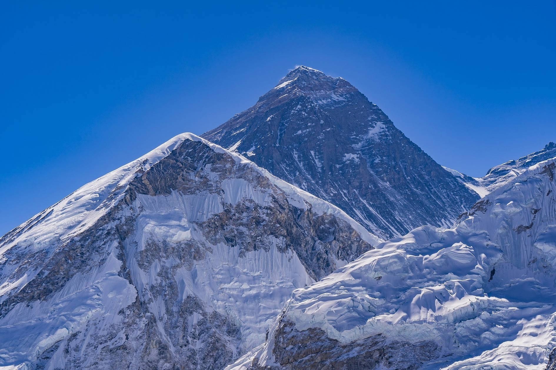
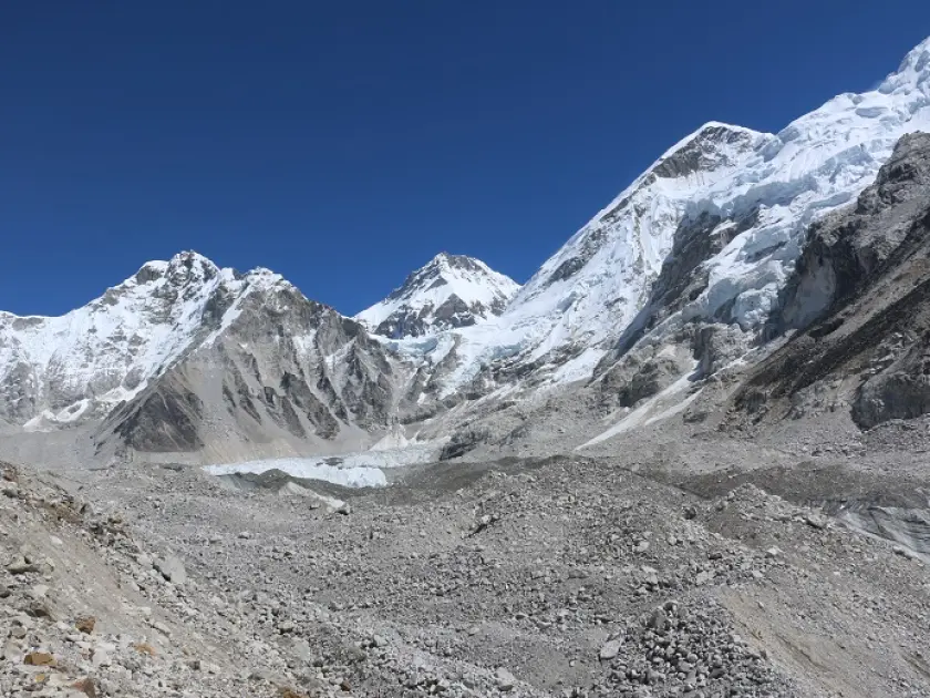
At the heart of it all towers Mount Everest, scraping the sky at 8,848 meters. Everest isn’t alone. Lhotse, Cho Oyu, Nuptse, and Ama Dablam stand close by, all massive, all magnets for mountaineers year after year. Glaciers like Khumbu feed the fast rivers below. Up high, the Gokyo Lakes—sitting between 4,700 and 5,000 meters—form the world’s highest freshwater system. Lower down, forests take over. Rhododendrons burst into color every spring, pines cluster thick and green, and animals adapt to the tough climate. Himalayan tahrs leap across the rocks. Eagles and other birds ride the wind above the valleys.
Managing all this isn’t easy, but the park steps up. They keep a close eye on human impact, striking a careful balance between protecting nature and letting people in. Buffer zones stretch the park’s protection even further. Local communities get involved with management, while rangers regularly patrol the land. Education campaigns help people understand why all this matters. Thanks to these efforts, Sagarmatha National Park doesn’t just survive—it thrives. Future generations will get to experience its wonders, too. The conservation work here really makes a difference.
Key Geographical Features:
Area: 1,148 km² in Solukhumbu District
Elevation Range: 2,845 meters at Monjo to 8,848 meters at Mount Everest
Major Rivers: Dudh Koshi and Bhote Koshi originate here
Glaciers: Khumbu Glacier and Ngozumpa Glacier dominate the landscape
Wetlands: Gokyo Lakes at 4,700-5,000 meters, a Ramsar site
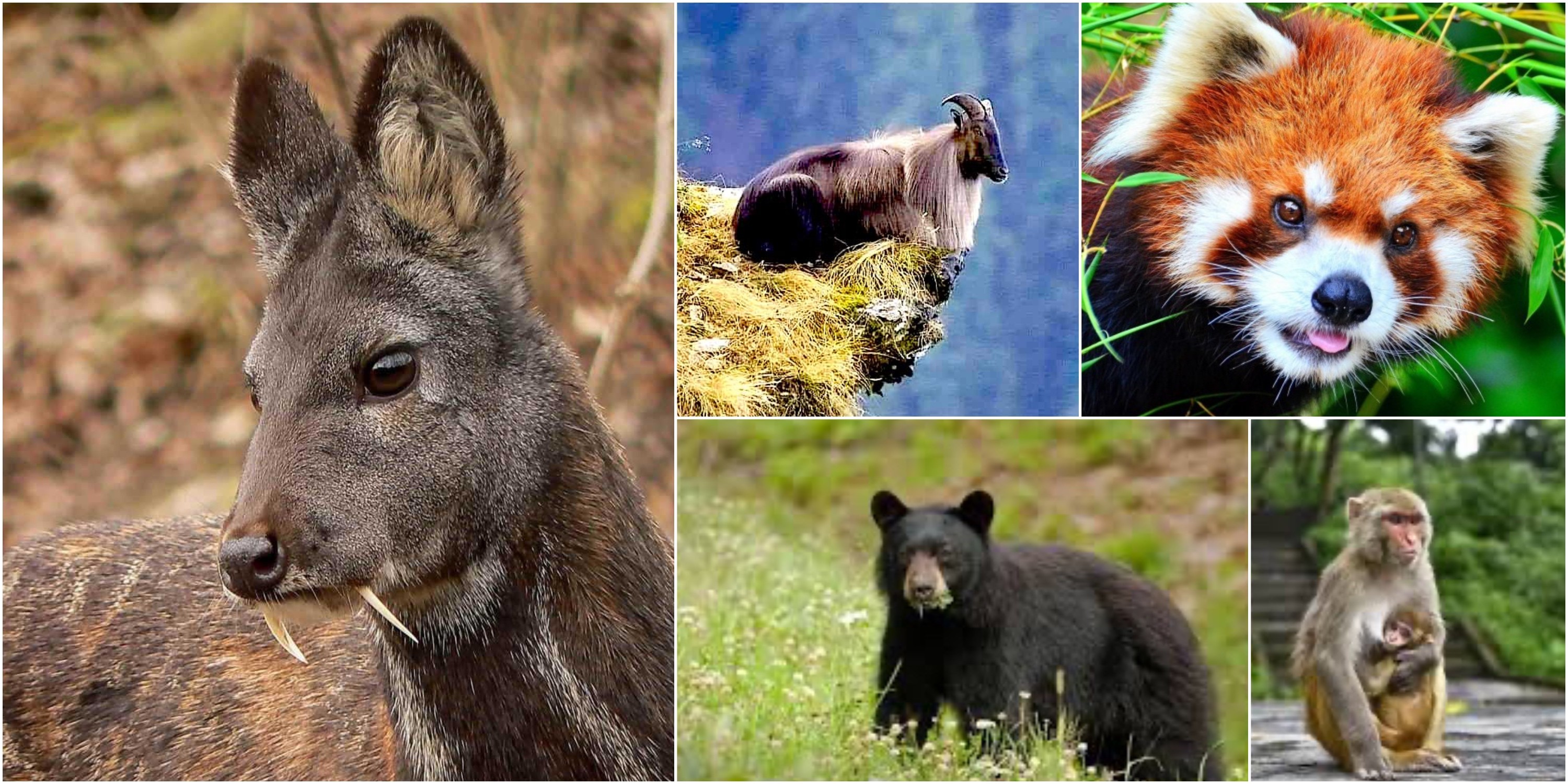
Fauna: Snow leopard (endangered) at high altitudes; red panda in bamboo zones; musk deer in forests
Bird Species: Himalayan monal and blood pheasant thrive here
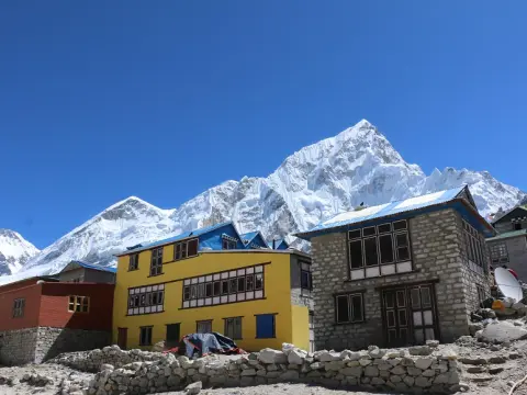
Human Element: Over 2,500 Sherpa residents maintain cultural sites like Tengboche Monastery at 3,867 meters
Conservation Zones
Area (km²)
Description
Core Zone
1,148
Strict protection for biodiversity.
Buffer Zone
275
Community-managed areas around park.
Origin of Sagarmatha National Park
Starting in 1971, specialists put forward a plan for Sagarmatha National Park. The suggestion came earlier from FAO consultants. By 1972, officials in Nepal gave their go-ahead. Their goal? Shielding delicate natural systems. After Everest was climbed in 1953, visitors began arriving more often. Mountaineers showed up in growing numbers. People living nearby felt mounting strain on nature. Animals required protection - fast. Even old ways need guarding. Deep in the hills, Sherpa customs grew strong over time. High peaks weren’t just rock - they carried prayers. Ice rivers fed streams below, drop by steady drop. Those flowing waters kept villages alive far away. Plants and animals struggled as people took too much. So plans began for a guarded stretch of land. Help came from afar - money arrived from New Zealand towns. From 1975 until 1980, help poured in steadily. Every corner of the area got checked by field crews. Local people joined talks without hesitation. Preparation for oversight fell to trained rangers. Out of those years rose a working example. Nature found space beside village life. Early actions laid firm groundwork. That beginning showed clear forward thinking.
In July, 1976 marked Nepal’s move to create Sagarmatha National Park. This place followed one earlier reserve, making it the nation’s second of its kind. By nineteen seventy nine, global attention arrived through UNESCO’s stamp of approval. A World Heritage title was given for standout reasons. What stands out? Young mountains rising with raw force. Ice rivers carving bold shapes across high stone.
Then there is the human layer - Sherpa traditions weaving depth into the land. Centuries passed with families making their home in those heights. Adjusting to thin air became part of daily life over time. Customs grew close to the rhythms of the wild around them. Places believed holy appeared across hills and valleys. Temples held tight to teachings handed down through ages. Trouble started showing up on footpaths left by travelers.
Likewise, litter began piling where few once walked. Trees thinned out as fires burned often. Space for animals to roam quietly got smaller each year. Rules came down hard when things reached a breaking point. Starting in 2002, buffer zones began shaping the landscape across 275 square kilometers. Local communities took charge of managing those spaces. Funding for initiatives came through tourism earnings instead. Knowledge sharing helped spread ways to live sustainably.
Moreover, watching for dangers became a daily task for rangers on duty. Over years, changes within the park followed new challenges closely. Handling fresh problems turned out smooth because of past steps. Right from the start, working together across borders shaped its path. What we protect today shapes what comes next.
Key Milestones in Establishment:
1971: FAO proposes national park for Everest region.
1972: Nepal government approves the concept.
1975-1980: New Zealand funds development and planning.
July 19, 1976: Park officially established, covering 1,148 km².
1979: UNESCO designates as Natural World Heritage Site.
2002: Buffer zone of 275 km² added for community involvement.
2007: Gokyo Lakes at 4,700-5,000 meters named Ramsar wetland.
Reasons for Origin
Details
Biodiversity Protection
Safeguard snow leopards, red pandas, and musk deer from habitat loss
Cultural Preservation
Protect Sherpa heritage, including Tengboche Monastery at 3,867 meters
Tourism Management
Control impacts after 1953 Everest summit increased visitors
Ecological Balance
Preserve glaciers like Khumbu and rivers like Dudh Koshi.
Influencing Factors:
Post-1953: Everest climb by Hillary and Tenzing sparks tourism boom.
1960s: Early visitors strain resources, prompting conservation needs.
Global Support: WWF conference in 1973 pushes for protection.
Local Role: Sherpa communities integrate into management for sustainability.
Management Evolution
Year
Key Addition
Initial Establishment
1976
Core area protection
UNESCO Recognition
1979
International status
Buffer Zone
2002
275 km² for locals
Major Highlights of Sagarmatha National Park,
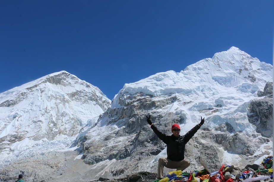
High above the clouds, Sagarmatha National Park unfolds across towering peaks of the Himalayas. Mount Everest stands within its borders, rising to 8,848 meters - tallest point on Earth. Alongside it stretch ancient glaciers cutting through rugged ravines. From Monjo’s entry gate at 2,845 meters, land climbs steeply skyward without pause. In recognition of its raw natural state, UNESCO granted heritage status here by 1979. Wild scenery pulls people here from every corner of Earth. Following trails such as Everest Base Camp draws many on foot. Sacred temples sit quietly where culture meets wild terrain.
Likewise, along high valleys, Sherpa life continues through generations. Rivers including Dudh Koshi begin their flow from ice fields above. Adventure waits where spirits rise above the trees. This place, called Sagarmatha National Park, claims its fame in Nepal’s highest corners
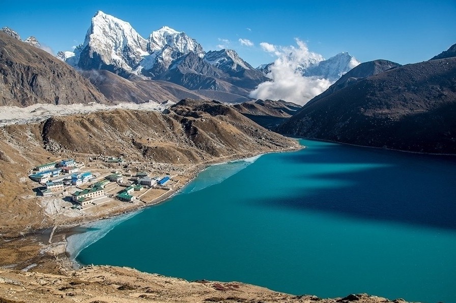
High up past Everest, the landscape opens into something wider. Turquoise pools shimmer under open sky - these are the Gokyo Lakes, perched like hidden mirrors. From Kala Patthar, which rises to 5,545 meters, mornings unfold in sweeping light across snow ridges. At 3,867 meters, Tengboche Monastery stands quiet, framed by towering summits. There, among stone walls and prayer flags, Ama Dablam looms large at 6,812 meters along with other sharp peaks cutting the horizon. When tourism grows, money flows into nearby towns in lasting ways. Even so, shifts in weather push scientists to watch changes closely.
Still, work to save nature keeps the area safe from harm. Visitors feel welcomed by traditions passed through generations of mountain people. Above all else, towering landscapes meet human stories in ways that stay with travelers long after they leave.
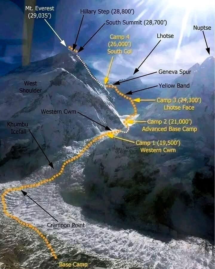
Mount Everest (8,848 m): Dominates the skyline as the world's highest peak.
Glaciers and Valleys: Include Khumbu Glacier and deep gorges.
Gokyo Lakes: Series of turquoise high-altitude lakes with Ngozumpa Glacier views.
Kala Patthar (5,545 m): Iconic viewpoint for Everest panoramas.
Elevation Range: 2,845 m to 8,848 m across dramatic terrain.
Major Cultural and Spiritual Attractions:
Tengboche Monastery (3,867 m): Spiritual center with Everest backdrop.
Mani Rimdu Festival: Held every year in Tengboche Monastery (3867m)
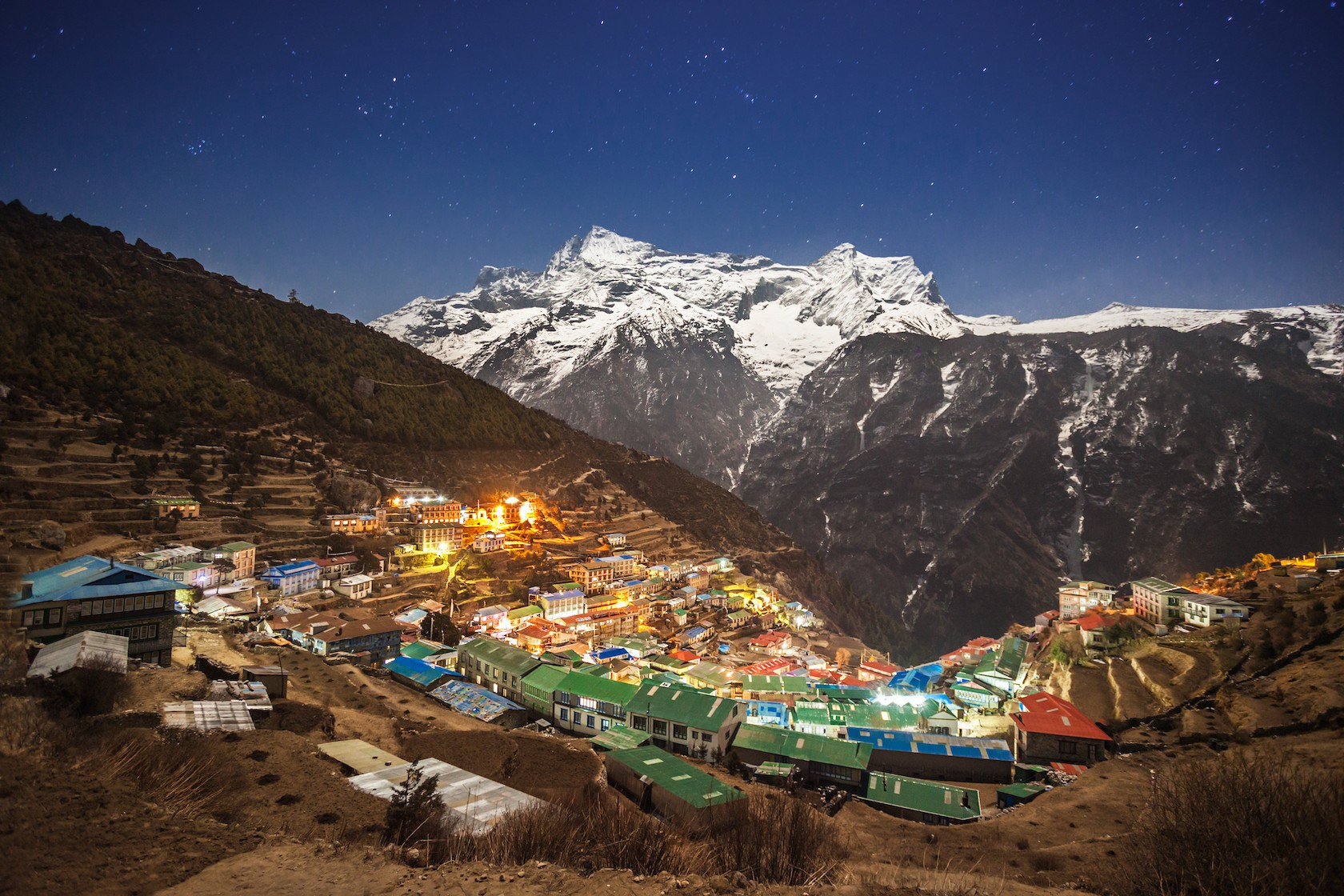
Sherpa Villages: Namche Bazaar (3,440 m) and Khumjung showcase traditions.
Ancient Monasteries: Thame and Pangboche preserve Buddhist heritage.
Route/Viewpoint
Elevation (m)
Key Highlights
Everest Base Camp Trek
Up to 5,364 at EBC
Views of Everest, Lhotse, Nuptse
Gokyo Lakes Trek
Up to 4,790 at Gokyo
Turquoise lakes, Cho Oyu views
Kala Patthar Summit
5,545
Sunrise over Everest
Tengboche Monastery
3,867
Panoramic peak views
Ama Dablam Base Camp
Around 4,600
Close-up of beautiful peak (6,812 m)
Peak Name
Elevation (m)
Notable Feature.
Mount Everest
8,848
World's highest.
Lhotse
8,516
Fourth highest globally.
Cho Oyu
8,201
Accessible from Gokyo.
Ama Dablam
6,812
Often called most beautiful.
Pumori
7,161
Striking near Everest.
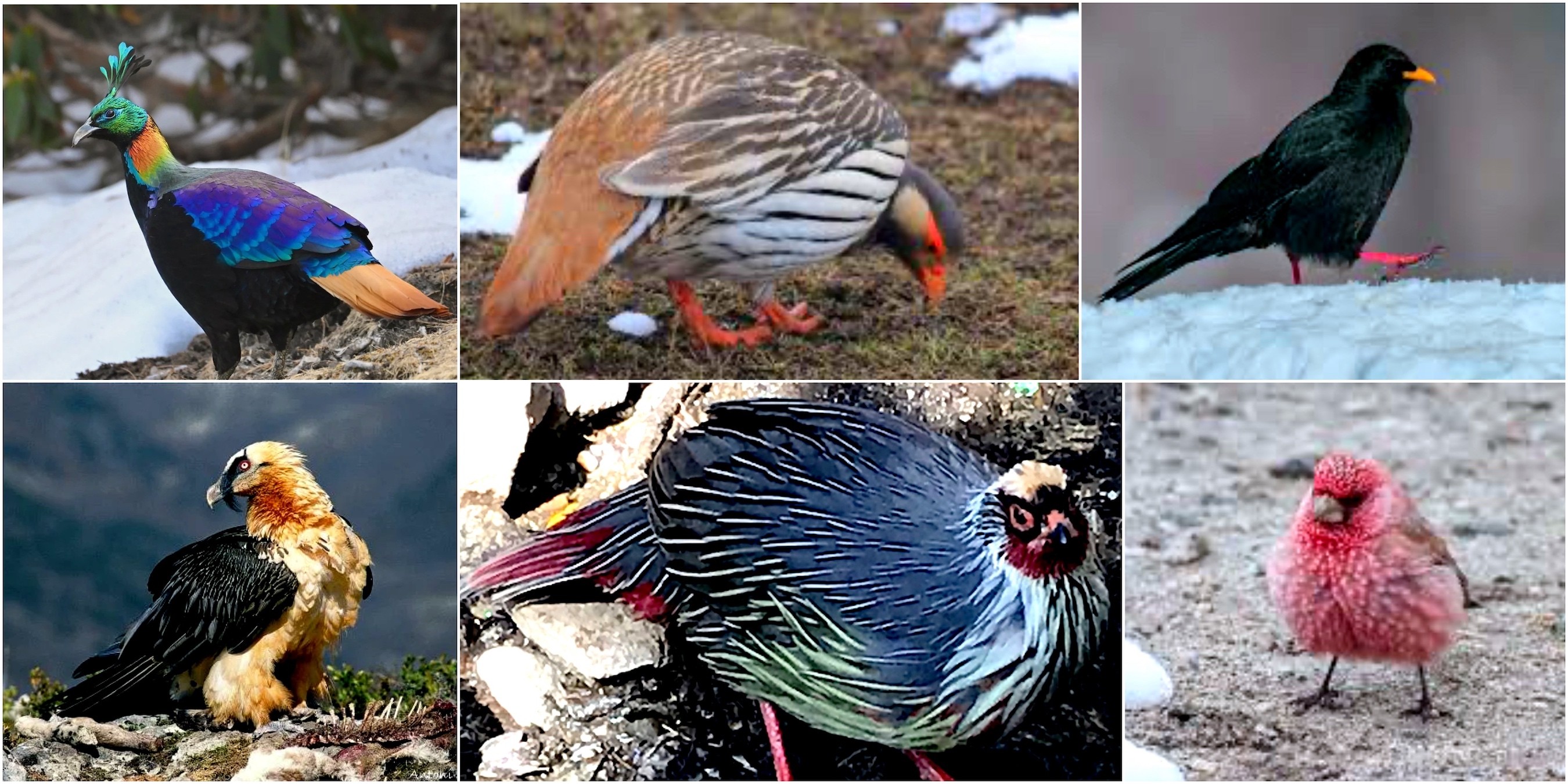
Major Flora and Fauna in Sagarmatha National Park
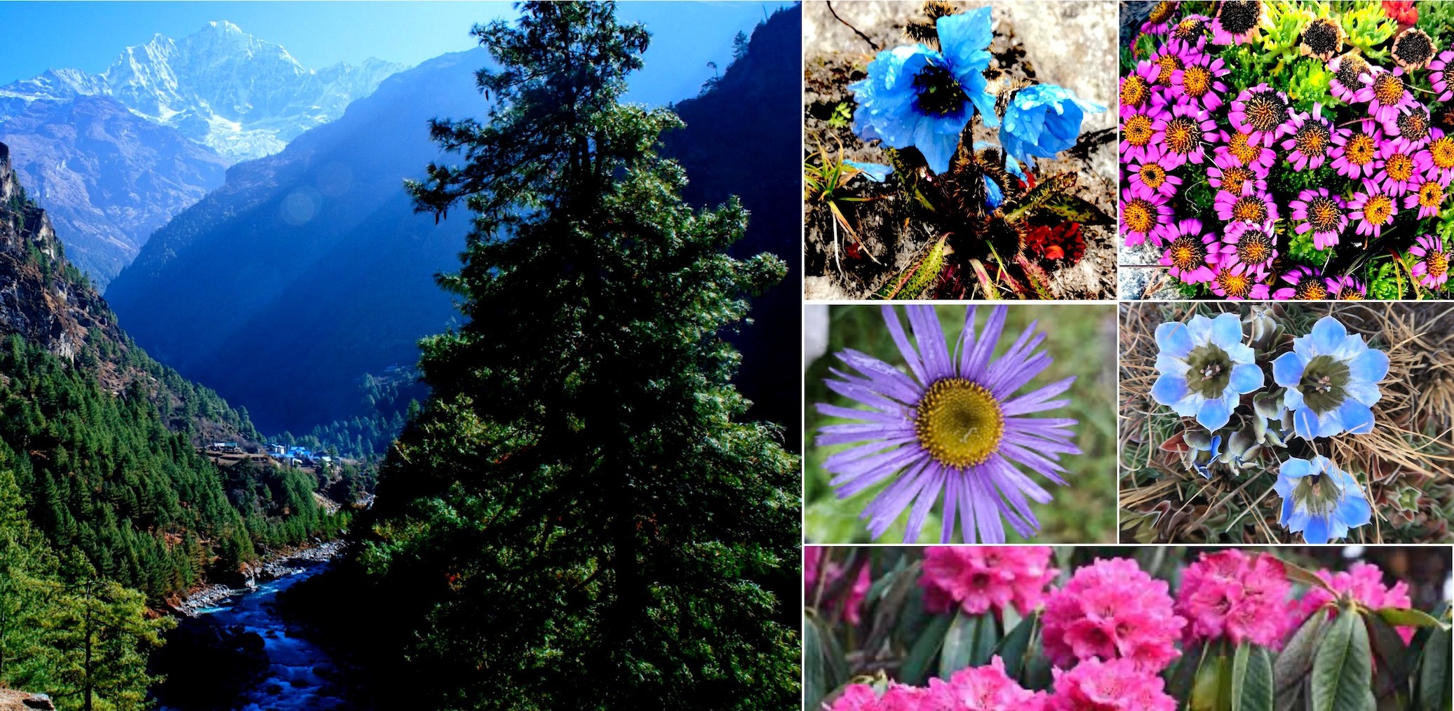
Sagarmatha National Park is a wild patchwork of life, shaped by altitude and raw weather. As you climb, everything changes. Thick forests fill the valleys below 4,000 meters, while higher up, the trees fade and alpine meadows take over. Spring hits, and the rhododendrons explode with color. Thanks to all these shifting zones, you’ll find over a thousand different plant species packed into the park.
Likewise, animals here are tough. Snow leopards slip through the rocks above the treeline, practically ghosts. Red pandas hide out in the bamboo groves. You’ll spot more than 200 types of birds, too, if you’re paying attention. The Sherpas, who’ve lived alongside this land for generations, show real respect for nature. Their traditions help keep the park’s biodiversity strong, even when the cold bites and the air thins.
Everest Base Camp Trek with Helicopter Fly Out 10 Days | 10 days
Moreover, the landscape keeps shifting as you go up. Mid-level slopes are full of juniper and birch. Push above 5,000 meters, and it’s mostly lichens and mosses holding on. Some of the animals here are endangered—musk deer, Himalayan tahr clinging to cliffs, and the showy Himalayan monal. The climate decides who can survive where. Lower slopes support dense life, while the harsh upper reaches demand serious adaptations. Efforts to protect the park pay off. In the end, all these plants and animals come together, creating a living mosaic in one of the world’s wildest places.
Vegetation Zones by Elevation:
Subalpine (below 3,600 m): Blue pine, fir, hemlock, juniper forests.
Rhododendron: Nepal's national flower, blooms brightly in forests.
Himalayan Blue Poppy: Rare alpine wildflower.
Juniper: Prevalent in scrub zones.
Himalayan Birch: Common in upper subalpine areas.
Edelweiss: Iconic high-altitude plant.
Key Fauna Species:
Snow Leopard: Elusive predator in high rocky areas.
Red Panda: Endangered, lives in bamboo undergrowth.
Musk Deer: Shy herbivore, prized for musk.
Himalayan Tahr: Agile goat-like animal on cliffs.
Himalayan Black Bear: Occasional in lower elevations.
Bird Species Highlights:
Bird Name
Habitat/Elevation
Notable Trait
Himalayan Monal
Forested zones
Colorful pheasant.
Blood Pheasant
Alpine meadows
Striking red markings.
Snowcock
High rocky areas
Camouflaged ground bird.
Bearded Vulture
Above tree line
Large scavenger.
Alpine Chough
Up to extreme heights
Seen near summits.
Endangered and Rare Wildlife:
Snow Leopard (Endangered): Rare sightings in upper zones.
Red Panda (Vulnerable): Threatened by habitat changes.
Musk Deer (Endangered): Poaching risk persists.
Himalayan Tahr: Stable but monitored.
Best Time to Visit Sagarmatha National Park
If you want the best out of Sagarmatha National Park, aim for spring (March to May) or autumn (September to November). These seasons just hit the sweet spot — clear skies, steady weather, and comfortable temperatures for trekking. Down in Namche Bazaar (3,440 m), you’ll see daytime highs around 10-15°C, but nights get chilly. Spring’s famous for the rhododendrons lighting up the trails, and in autumn, the air feels crisp and you get those sharp, postcard-worthy views of Mount Everest (8,848 m).
Likewise, Monsoon season (June to August) is another story. The rain pours, trails get slick and muddy, and the views pretty much disappear. Winter (December to February) gets brutally cold, with snow making the high passes almost impossible. So honestly, spring and autumn give you the best shot at a comfortable and spectacular trip.
Here, the park’s elevation changes everything too. Down in Monjo (2,845 m), the weather’s a bit gentler, but up near Everest Base Camp (5,364 m), it’s harsher and colder. Clear days don’t just mean great photos — they’re safer for trekking too. If you want to avoid the crowds, skip October and November when it gets busy, and try March or April instead. Sometimes you’ll catch local festivals, which add something special to the experience.
Pack smart while visiting Sagarmatha National Park. You’ll need layers for those unpredictable swings in temperature, and make sure you give yourself time to acclimatize so you stay healthy at altitude. Bottom line: plan your visit for spring or autumn. You’ll get the best views, the most comfortable weather, and a safer, more enjoyable experience in Sagarmatha National Park.
Winter: Pros - Solitude, snowy scenery; Cons - Extreme cold, closed high passes like Cho La (5,420 m).
Major Activities During Your Visit to Sagarmatha National Park
Actually, Sagarmatha National Park isn’t just a place you visit—it’s an experience that sweeps you in from the start. Most people come for the trekking, and honestly, it’s easy to see why. The trails lead you to incredible places like Everest Base Camp at 5,364 meters. If you’re up for it, you can push higher to viewpoints like Kala Patthar, which sits at 5,545 meters and gives you that classic panorama of Everest and its neighbors.
But the story isn’t just about the mountains. The Sherpa villages along the way make you feel right at home, always ready with a warm welcome. Monasteries dot the landscape, and Tengboche Monastery really stands out—it’s peaceful, a great spot to just stop and take it all in. If you’re lucky, you might catch a glimpse of a snow leopard or a red panda hiding out in the forest. Bring your camera because the views of Ama Dablam or the turquoise Gokyo Lakes are unreal.
There’s more, too. Climbers test themselves on peaks like Island Peak, while others spend time learning about Sherpa traditions and daily life. Teahouses give you a cozy place to rest at the end of a long day, and acclimatization days help you catch your breath.
If you’re into photography, you’ll chase that perfect golden-hour shot. Birdwatchers will love spotting the Himalayan monal, the park’s colorful resident. And all along the way, real conversations and connections with the local community make the journey even richer.
Everest Base Camp Trek without Lukla Flight | 16 days
In the end, Sagarmatha National Park brings together adventure, culture, and a sense of calm you don’t find just anywhere. It’s not just a trip—it’s something you take with you long after you leave.
Primary Trekking Activities:
Everest Base Camp Trek: Classic route to EBC (5,364 m) via Namche Bazaar (3,440 m).
Gokyo Lakes Trek: Explores turquoise lakes and Gokyo Ri (5,357 m) viewpoint.
Everest Three Passes Trek: Crosses Renjo La (5,340 m), Cho La (5,420 m), Kongma La (5,535 m).
Kala Patthar Sunrise Hike: Panoramic views of Everest (8,848 m) from 5,545 m.
Cultural and Sightseeing Experiences:
Visit Tengboche Monastery (3,867 m): Observe Buddhist rituals and architecture.
Explore Namche Bazaar (3,440 m): Shop, acclimatize, learn Sherpa life.
Interact with Sherpa communities: Experience hospitality, cuisine, traditions.
Tour ancient gompas and chortens: Absorb spiritual heritage.
Adventure and Specialized Activities:
Activity
Location/Elevation
Description
Peak Climbing
Island Peak (6,189 m), Lobuche East
Guided ascents for experienced climbers
Wildlife Photography
Various trails 3,000-5,000 m
Spot snow leopard, red panda, birds
Birdwatching
Forested and alpine zones
Observe Himalayan monal, blood pheasant
Glacier Exploration
Khumbu Glacier near EBC
View icefalls and moraines
Additional Popular Pursuits:
Photography of Himalayan giants: Capture Lhotse (8,516 m), Cho Oyu (8,201 m).
Teahouse trekking: Stay in local lodges, enjoy Sherpa meals.
Acclimatization walks: Short hikes around villages for safety.
Helicopter tours: Aerial views for those short on time.
General Rules for Visiting Sagarmatha National Park
Here, treat Sagarmatha National Park with respect—it’s a delicate place. Don’t leave trash behind; take everything out with you. Stick to the designated trails and never toss plastic or litter. Show respect for Sherpa culture. A simple “Namaste” goes a long way when greeting locals, and always spin prayer wheels clockwise.
Leave wildlife alone—don’t try to feed the animals. Campfires are off-limits in most places. The goal is to protect the park’s biodiversity, so keep your impact as light as possible. Use teahouses thoughtfully, and support the local economy while you’re at it. Follow acclimatization guidelines closely. These rules all help keep the Everest region (8,848 m) pristine, so future visitors can enjoy it too.
Likewise, the park doesn’t mess around when it comes to conservation. You need the right permits, and you’ll show them at checkpoints like Monjo (2,845 m). Don’t wander off-trail unless you have special permission. If you want to take someone’s photo, always ask first. Keep the noise down—quiet hours matter, especially if you’re near a monastery like Tengboche (3,867 m). Dress modestly in these sacred places, and ditch single-use plastics. Guides can help you figure out the local customs if you’re unsure. Bottom line: these rules aren’t just red tape—they’re here to protect the park, honor local culture, and keep everyone safe.
Essential Environmental Rules:
Carry out all trash; use designated bins or pack it down.
Stay on marked trails to prevent erosion.
No campfires; use teahouse stoves only.
Avoid single-use plastics; bring reusable items.
Do not feed or disturb wildlife like snow leopards or red pandas.
Cultural and Social Etiquette:
Greet with "Namaste" and palms together.
Turn prayer wheels clockwise only.
Ask permission before photographing locals or ceremonies.
Dress modestly (cover shoulders and knees) at monasteries.
Respect sacred sites; do not step over mani stones.
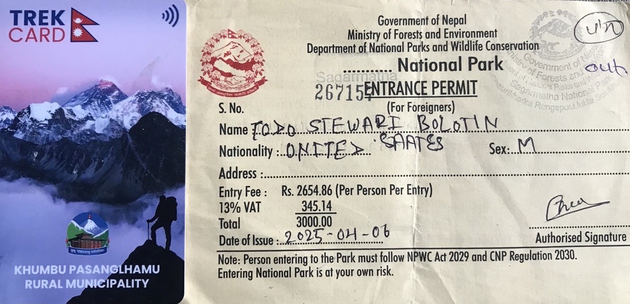
Entry Tickets and Fees of Sagarmatha National Park
If you want to trek in Sagarmatha National Park, you need a permit—no way around it. Trekkers have to buy the Sagarmatha National Park Entry Permit. For foreigners, that’s NPR 3,000 each. SAARC nationals get a discount and pay NPR 1,500. Nepali citizens pay just NPR 100, sometimes even less.
On top of that, there’s the Khumbu Pasang Lhamu Rural Municipality Permit, which usually sets foreigners back another NPR 3,000. These fees aren’t just a formality—they actually go toward conservation work and community projects in the region. Kids under 10? They get in free. Permits are checked at various points, so don’t forget to sort them out before you hit the trail. With these tickets, you’re all set to explore iconic spots like Everest Base Camp at 5,364 meters.
Getting your permits for Sagarmatha National Park or EBC Trek is pretty straightforward. You can pick up the national park permit either in Kathmandu or at Monjo (2,845 m), depending on where you start. The rural municipality fee usually gets collected at Lukla airport. No need for a TIMS card anymore—that requirement’s gone. Sometimes, the fees include VAT, so the total for foreigners comes out to around NPR 5,000.
In fact, permits aren’t refundable and they’re usually good for a single entry. In the end, these entry tickets and fees aren’t just red tape—they help protect the park and open the door to legendary Himalayan adventures, including Mount Everest at 8,848 meters.
Required Permits and Costs (Current as of 2026)
Permit Type Foreigners (NPR) SAARC Nationals (NPR) Nepali Citizens (NPR) Notes
Sagarmatha National Park Entry Permit 3,000 1,500 100 Mandatory; children under 10 free
Khumbu Pasang Lhamu Rural Municipality Permit 2,000 1,000–2,000 500–2,000 Local entry fee; varies by group/independent
Total Approximate for Foreigners 5,000 2,500–3,500 N/A Plus possible VAT
Where to Obtain Permits:
Nepal Tourism Board Office, Kathmandu: For Sagarmatha National Park Permit.
Monjo Entry Checkpoint: Alternative for park permit.
Lukla Airport or Local Office: For Khumbu Pasang Lhamu Permit.
Licensed Trekking Agencies: Handle both in advance.
Additional Fee Considerations:
Children under 10 years: Free entry to park.
TIMS Card: Not required for Everest region treks.
Payment: In Nepalese Rupees only at most points.
Validity: Single entry; show at multiple checkpoints.
Purpose: Funds wildlife protection, trail maintenance, and Sherpa community development.
Accessibility from Kathmandu to Sagarmatha National Park
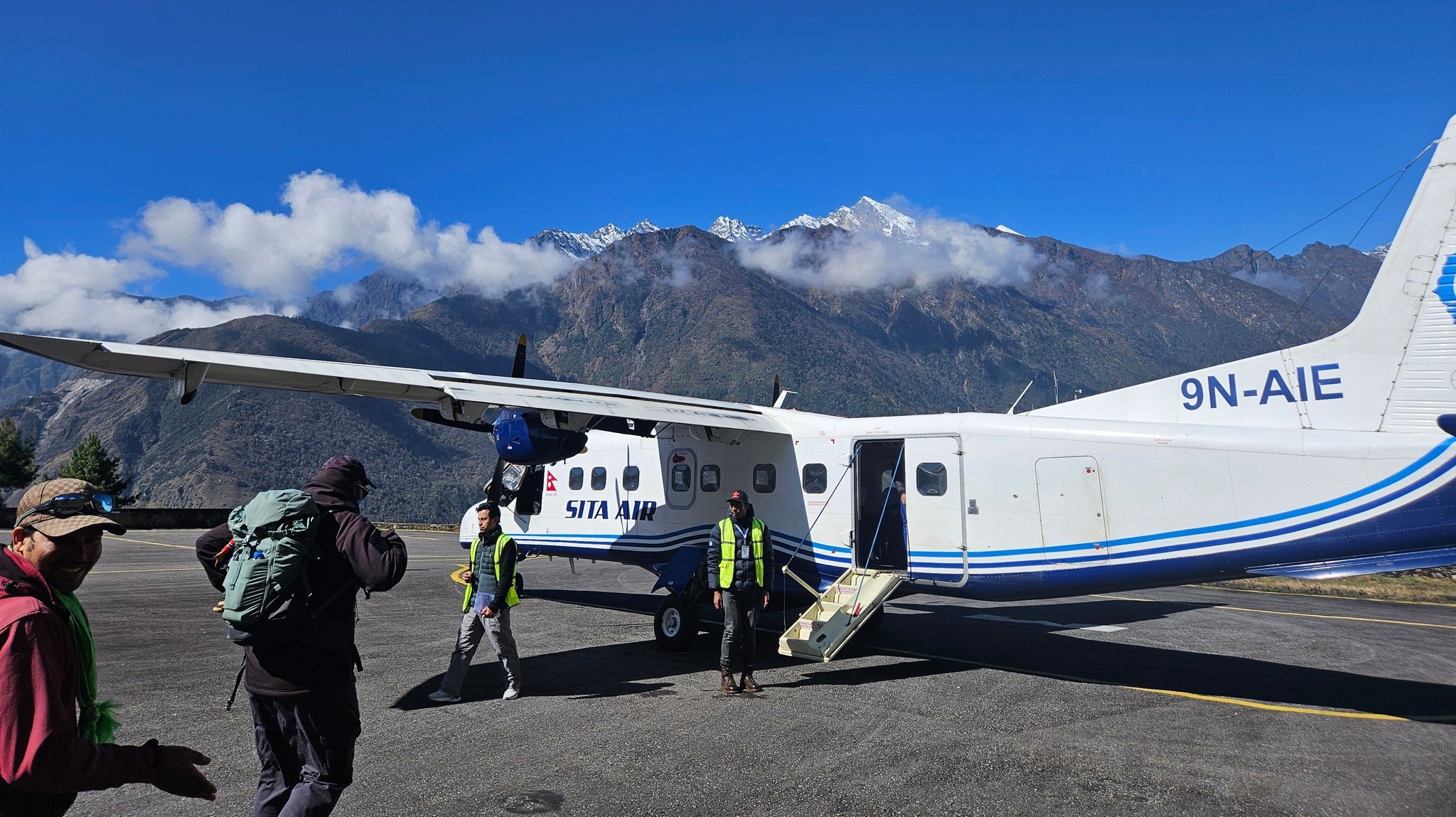
Getting to Sagarmatha National Park from Kathmandu is pretty straightforward, especially if you’re aiming for speed. Most people hop on a short flight—just 25 to 35 minutes—from Kathmandu to Lukla. Lukla’s up at 2,860 meters, and from there, it usually takes about two days of trekking to reach Namche Bazaar at 3,440 meters.
If you’re not flying, you’ve got overland options too. You can catch a bus/jeep to places like Jiri or Salleri or Surke from Kathmandu, but be ready for the long haul—those routes mean 8 to 10 hours or 14-16 hours to Surke, on the road, followed by several days of trekking to reach the park. During peak trekking seasons, flights to Lukla run daily, though the weather has the final say. Helicopters are another option if you want to skip the crowds and save time, but they’re not as common.
Once you’re trekking to Everest Base Camp, the first official entry point is Monjo at 2,845 meters. You’ll show your permits there before heading higher up the trail toward hotspots like Everest Base Camp. Domestic airlines like Tara Air handle most of the Lukla flights, and road conditions are slowly getting better, making land routes a bit less grueling than they used to be. Still, delays happen—bad weather, traffic, you name it—so it pays to keep your schedule flexible.
Island Peak Climb with Everest Base Camp Trek | 21 days
Bottom line: Kathmandu connects you to Sagarmatha National Park quickly by air, but even the long road routes have their own charm if you’re up for the adventure. Either way, getting there is all part of the experience.
Main Access Routes from Kathmandu:
Flight to Lukla (Most Popular): 25-35 minutes flight; then 2-3 days trek to Namche Bazaar (3,440 m).
Bus + Trek via Jiri: 8-10 hours bus to Jiri; 8-10 days trek to park entry.
Bus to Salleri/Phaplu: 8-10 hours drive; 5-7 days trek onward.
Helicopter Option: Direct or via Lukla; 1 hour or less, higher cost.
Flight Details (Kathmandu to Lukla, Approximate 2026)
Monjo: 2,845 m – Sagarmatha National Park entry gate.
Namche Bazaar: 3,440 m – First major Sherpa hub after entry.
Phakding: 2,610 m – Common overnight stop post-Lukla.
Sustainable Tourism in Sagarmatha National Park
Here, Sagarmatha National Park doesn’t just talk about sustainable tourism—it lives it every day. Park authorities take waste management seriously. You’ll see local committees out there, collecting trash and making sure the rules stick. The Sagarmatha Pollution Control Committee does a lot of the heavy lifting. Thanks to strict plastic bans, there’s a real drop in pollution.
Actually, community buffer zones bring locals right into the heart of conservation, and everyone gets a fair share of the tourism revenue. Trekkers stick to “leave no trace,” and teahouses go for greener, more eco-friendly ways of doing business. All of this helps protect Mount Everest’s incredible biodiversity. Visitors get to enjoy the park, but not at the environment’s expense. This kind of balance keeps Sagarmatha thriving for the next generation.
There’s more. The park doesn’t shy away from climate change. Management teams keep a close eye on glacier retreat and push for low-impact trekking. Local Sherpa communities lead their own sustainable programs—many even run their own lodges, setting the standard.
Further, UNESCO backs these ongoing efforts, and regular studies make sure visitor numbers don’t go overboard. Education campaigns keep everyone in the loop, so people know why all this matters. In the end, Sagarmatha’s approach blends conservation, community benefits, and smart tourism. It’s a model built for the long haul.
Key Sustainable Initiatives:
Sagarmatha Pollution Control Committee (SPCC): Manages waste collection, recycling, and awareness.
Plastic Ban in Khumbu Region (since 2020): Prohibits single-use plastics to cut pollution.
Buffer Zone Program: Shares revenue with locals for conservation and development.
Biogas Systems: Convert human waste to energy in high camps.
Community Involvement: Sherpas participate in trail maintenance and eco-tourism.
Waste Management and Conservation Practices
Practice Description Impact/Location
Waste Collection & Recycling SPCC organizes daily pickups Trails, villages like Namche (3,440 m)
Leave No Trace Principles Trekkers pack out all waste Entire park, enforced at checkpoints
Eco-Friendly Teahouses Use solar power, minimal water use Lodges in Phakding (2,610 m) to Gorak Shep (5,164 m)
Biogas & Composting Toilets Reduce open defecation pollution High-altitude base camps
Trekking Route Diversification Spreads visitor load to lessen erosion Alternative paths to Gokyo Lakes
Benefits and Challenges Addressed:
Community Revenue Sharing: Funds local projects, schools, health.
Wildlife Protection: Regulated trekking minimizes disturbance to snow leopards, red pandas.
Climate Adaptation: Monitoring programs track glacial changes near Everest (8,848 m).
Education & Awareness: Campaigns for visitors and locals on sustainability.
FAQS:
1. What is Sagarmatha National Park? Sagarmatha National Park is a UNESCO World Heritage Site in Nepal’s Khumbu region. It has Mount Everest and the beautiful Himalayan mountains. Sagarmatha National Park was made in 1976. It covers a big area of 1,148 square kilometers. This park has lots of plants and animals and it is great for people who like to trek and go on adventures. 2. Where is Sagarmatha National Park located? Sagarmatha National Park is in the Solukhumbu District in Nepal. It is near the border with Tibet. It surrounds Mount Everest. You can get to Sagarmatha National Park by flying to Lukla from Kathmandu. This makes it a great place for people from around the world to come and visit. 3. When was Sagarmatha National Park established? Sagarmatha National Park was officially made on July 19 1976. This was done to protect the environment around Mount Everest. In 1979 Sagarmatha National Park became a UNESCO World Heritage Site. This means that it is an important place and it needs to be protected for future generations. 4. What are the major highlights of Sagarmatha National Park? Sagarmatha National Park has lots of things to see. You can visit Mount Everest, Tengboche Monastery, Namche Bazaar, Gokyo Lakes and the Khumbu Glacier. You can also see the villages where the Sherpa people live. The park is very beautiful. It has lots of different plants and animals. This makes it a great place for people who like to trek and go on adventures. 5. What flora and fauna live in Sagarmatha National Park? Sagarmatha National Park has lots of plants like rhododendron, pine and juniper trees. It also has animals like snow leopards, red pandas and musk deer. You can see birds like the Himalayan monal. All of these plants and animals live in parts of the park from the low valleys to the high mountains. 6. What is the best time to visit Sagarmatha National Park? The best time to visit Sagarmatha National Park is in the spring or the autumn. In the spring the rhododendron flowers are. It is very beautiful. In the autumn the weather is clear. It is a great time to see the mountains. These are the times to trek and to see the parks natural beauty. 7. What activities can I do in Sagarmatha National Park? There are lots of things you can do in Sagarmatha National Park. You can trek to Everest Base Camp visit the Gokyo Lakes or go to the Tengboche Monastery. You can also see the wildlife take pictures and learn about the Sherpa culture. If you like adventure you can go hiking explore the glaciers or take a helicopter tour. 8. What are the entry tickets and fees for Sagarmatha National Park? To get into Sagarmatha National Park you need to pay a fee. It costs NPR 3,000 for foreigners NPR 1,500 for people from SAARC countries and NPR 100 for citizens. You also need to get a permit from the Khumbu Rural Municipality. You can get the permits in Kathmandu or at the park entrance. 9. How do I reach Sagarmatha National Park from Kathmandu? To get to Sagarmatha National Park from Kathmandu you can fly to Lukla. It takes 35 minutes. Then you can trek to the park entrance. There are also ways to get to the park like taking a bus or walking but flying is the fastest way. 10. What are the general rules for visiting Sagarmatha National Park? When you visit Sagarmatha National Park you need to follow some rules. You need to get a permit do not. Respect the wildlife and the monasteries. You should stay on the trails. Not disturb the local people. You are not allowed to have campfires. You need to be careful with the altitude. 11. Is Sagarmatha National Park suitable for beginners? Sagarmatha National Park can be challenging because of the altitude. There are some easy treks and day hikes that beginners can do. If you are a beginner you should go with a guide. Make sure you are prepared. You need to be fit and have the gear. 12. How important is sustainable tourism in Sagarmatha National Park? Sustainable tourism is very important in Sagarmatha National Park. It helps to protect the environment and support the people. We need to be careful with the waste respect the culture and not disturb the wildlife. This way we can help to keep the park beautiful and safe for generations. 13. Do I need permits besides the park entry fee? Yes, you need to get a permits to visit Sagarmatha National Park. You need the park permit and the Khumbu Pasang Lhamu Rural Municipality Permit. You might also need a TIMS card depending on your trek. You should always check the rules before you go. 14. What should I pack for Sagarmatha National Park visit? When you pack for Sagarmatha National Park you should bring clothes, good trekking boots and a sleeping bag. You should also bring sunglasses, sunscreen and a first-aid kit. You need to be prepared for the altitude and the changing weather. 15. Are there accommodation options inside Sagarmatha National Park? Yes, there are places to stay in Sagarmatha National Park. You can stay in teahouses and lodges in the villages like Namche Bazaar and Tengboche. The accommodations are simple but comfortable. You should book in advance during the peak season. 16. How high is Mount Everest in Sagarmatha National Park? Mount Everest is the mountain in the world. It is 8,848.86 meters high. It is an impressive sight and it attracts many climbers and trekkers. 17. Can I see wildlife in Sagarmatha National Park? Yes, you can see wildlife in Sagarmatha National Park. There are snow leopards, red pandas and musk deer. You can also see birds like the Himalayan monal. If you are quiet and patient you might be able to see some of these animals. 18. What cultural experiences are available in the park? Sagarmatha National Park has a culture. You can visit the monasteries like Tengboche Monastery. Learn about the Sherpa people. You can also see the villages and festivals. This is a way to learn about the local culture and way of life. 19. Is altitude sickness a concern in Sagarmatha National Park? Yes, altitude sickness is a risk in Sagarmatha National Park. You need to be careful and take your time when you are trekking. You should drink plenty of water eat well and not go too high fast. You should also be prepared for the altitude. Have the right medication. 20. Why should I choose Sagarmatha National Park package? The Sagarmatha National Park package is a way to visit the park. It includes a guide, permits and accommodations. You will be able to trek and comfortably and you will be able to learn about the culture and the environment. This is a way to have a memorable adventure, in Sagarmatha National Park.