[{"name":"Everest Base Camp Helicopter Tour","duration":"1","image_url":"https:\/\/www.havenholidaysnepal.com\/storage\/trip-galleries\/1\/thumb_6cd53005d75a86e373d31419d1b14d78.webp","offer_price":1195,"url":"https:\/\/www.havenholidaysnepal.com\/trips\/everest-base-camp-helicopter-tour"},{"name":"Everest Mountain Flight","duration":"1","image_url":"https:\/\/www.havenholidaysnepal.com\/storage\/trip-galleries\/4\/thumb_3b0b4f1d6f72b0ad224daf4752f2c6e0.jpg","offer_price":285,"url":"https:\/\/www.havenholidaysnepal.com\/trips\/everest-mountain-flight"},{"name":"Everest Short Trek","duration":"9","image_url":"https:\/\/www.havenholidaysnepal.com\/storage\/trip-galleries\/5\/thumb_BXPP3621.JPEG0.02033800 1727957098.webp","offer_price":995,"url":"https:\/\/www.havenholidaysnepal.com\/trips\/everest-short-trek"},{"name":"Gokyo Valley Trek","duration":"12","image_url":"https:\/\/www.havenholidaysnepal.com\/storage\/trip-galleries\/6\/thumb_10bc469b14731f23d3ce84a7092ad53f.jpg","offer_price":1195,"url":"https:\/\/www.havenholidaysnepal.com\/trips\/gokyo-valley-trek"},{"name":"15 days Annapurna Base Camp Trek","duration":"15","image_url":"https:\/\/www.havenholidaysnepal.com\/storage\/trip-galleries\/7\/thumb_87d1533bc45faf070990aef0579e4be4.jpg0.81855100 1728285496.webp","offer_price":785,"url":"https:\/\/www.havenholidaysnepal.com\/trips\/15-days-annapurna-base-camp-trek"},{"name":"Nepal Pilgrimage Tour","duration":"14","image_url":"https:\/\/www.havenholidaysnepal.com\/storage\/trip-galleries\/8\/thumb_02c3bcf2ad2e8a4c1703e90ae747b5f1.jpg","offer_price":1475,"url":"https:\/\/www.havenholidaysnepal.com\/trips\/nepal-pilgrimage-tour"},{"name":"UNESCO World Heritage Site Tour","duration":"10","image_url":"https:\/\/www.havenholidaysnepal.com\/storage\/trip-galleries\/9\/thumb_unesco-world-heritage-site-Lumbani-temple-buddhists-hindus-kathmandu-nepal0.36988600 17347617740.93089500 1737469667.webp","offer_price":715,"url":"https:\/\/www.havenholidaysnepal.com\/trips\/unesco-world-heritage-site-tour"},{"name":"Island Peak Climbing","duration":"16","image_url":"https:\/\/www.havenholidaysnepal.com\/storage\/trip-galleries\/11\/thumb_Island peak0.53947000 1734692503.webp","offer_price":2495,"url":"https:\/\/www.havenholidaysnepal.com\/trips\/island-peak-climbing"},{"name":"Upper Mustang Trek","duration":"18","image_url":"https:\/\/www.havenholidaysnepal.com\/storage\/trip-galleries\/12\/thumb_upper mustang 7 Oct-2024.jpg0.95398900 1728286166.webp","offer_price":2995,"url":"https:\/\/www.havenholidaysnepal.com\/trips\/upper-mustang-trek"},{"name":"Annapurna Circuit Trek","duration":"16","image_url":"https:\/\/www.havenholidaysnepal.com\/storage\/trip-galleries\/15\/thumb_tibetan-flags.jpg0.04843900 1728289138.webp","offer_price":985,"url":"https:\/\/www.havenholidaysnepal.com\/trips\/annapurna-circuit-trek"},{"name":"Gosainkunda Lake Trek","duration":"10","image_url":"https:\/\/www.havenholidaysnepal.com\/storage\/trip-galleries\/16\/thumb_5A8083B3-C007-41A8-853F-D0C37C97D235_1_105_c.jpeg0.52581200 1731845258.webp","offer_price":595,"url":"https:\/\/www.havenholidaysnepal.com\/trips\/gosainkunda-lake-trek"},{"name":"Zip-lining in Pokhara and Dhulikhel","duration":"1","image_url":"https:\/\/www.havenholidaysnepal.com\/storage\/trip-galleries\/18\/thumb_215f765e2ebc995dd5c800b4bfdbacc3.jpg","offer_price":82,"url":"https:\/\/www.havenholidaysnepal.com\/trips\/zip-lining-in-pokhara-and-dhulikhel"},{"name":"Annapurna Heli Tour","duration":"1","image_url":"https:\/\/www.havenholidaysnepal.com\/storage\/trip-galleries\/19\/thumb_d71a6bbb9fd4da8d1b567a5cdbdec85d.jpg","offer_price":555,"url":"https:\/\/www.havenholidaysnepal.com\/trips\/annapurna-heli-tour"},{"name":"Paragliding in Pokhara","duration":"1","image_url":"https:\/\/www.havenholidaysnepal.com\/storage\/trip-galleries\/20\/thumb_de788d2dd9726783431f882c007efae1.jpg","offer_price":65,"url":"https:\/\/www.havenholidaysnepal.com\/trips\/paragliding-in-pokhara"},{"name":"Ultra-Flight in Pokhara","duration":"1","image_url":"https:\/\/www.havenholidaysnepal.com\/storage\/trip-galleries\/21\/thumb_e27a9fb572a5c21611bb2a3c18e4b8f0.jpeg","offer_price":175,"url":"https:\/\/www.havenholidaysnepal.com\/trips\/ultra-flight-in-pokhara"},{"name":"Sarangkot Hiking","duration":"1","image_url":"https:\/\/www.havenholidaysnepal.com\/storage\/trip-galleries\/22\/thumb_100ef822fea19987166c6c1366215f15.jpg","offer_price":55,"url":"https:\/\/www.havenholidaysnepal.com\/trips\/sarangkot-hiking"},{"name":"Mera Peak Climbing","duration":"18","image_url":"https:\/\/www.havenholidaysnepal.com\/storage\/trip-galleries\/24\/thumb_d16ae3895f678cf26ffbf2455f541fb5.jpg0.31883400 1732617790.webp","offer_price":2475,"url":"https:\/\/www.havenholidaysnepal.com\/trips\/mera-peak-climbing"},{"name":"Lower Dolpo Trek","duration":"18","image_url":"https:\/\/www.havenholidaysnepal.com\/storage\/trip-galleries\/26\/thumb_Dolpo Galary - 1.JPG0.37725200 1727939952.webp","offer_price":2995,"url":"https:\/\/www.havenholidaysnepal.com\/trips\/lower-dolpo-trek"},{"name":"Nagarkot Sunrise\/Sunset Tour","duration":"1","image_url":"https:\/\/www.havenholidaysnepal.com\/storage\/trip-galleries\/27\/thumb_5147a5532644283a380f2e86f3857c13.jpg0.17748000 1728488108.webp","offer_price":30,"url":"https:\/\/www.havenholidaysnepal.com\/trips\/nagarkot-sunrise-sunset-tour"},{"name":"16 day Everest Base Camp Trek","duration":"16","image_url":"https:\/\/www.havenholidaysnepal.com\/storage\/trip-galleries\/28\/thumb_IMG_4311.JPG0.64984800 1727942213.webp","offer_price":1475,"url":"https:\/\/www.havenholidaysnepal.com\/trips\/16-day-everest-base-camp-trek"},{"name":"Ghorepani Poon Hill trek with Jungle Safari and Trishuli River Rafting -13 days","duration":"13","image_url":"https:\/\/www.havenholidaysnepal.com\/storage\/trip-galleries\/29\/thumb_Ghorepani Poon hill.jpg0.48460800 1728281439.webp","offer_price":795,"url":"https:\/\/www.havenholidaysnepal.com\/trips\/ghorepani-poon-hill-trek-with-jungle-safari-and-trishuli-river-rafting--13-days"},{"name":"Mardi Himal Trek","duration":"12","image_url":"https:\/\/www.havenholidaysnepal.com\/storage\/trip-galleries\/30\/thumb_s1.jpg0.62112600 1728200721.webp","offer_price":795,"url":"https:\/\/www.havenholidaysnepal.com\/trips\/mardi-himal-trek"},{"name":"Langtang Valley Trekking","duration":"10","image_url":"https:\/\/www.havenholidaysnepal.com\/storage\/trip-galleries\/31\/thumb_IMG_4702.JPG0.84916500 1727958504.webp","offer_price":685,"url":"https:\/\/www.havenholidaysnepal.com\/trips\/langtang-valley-trekking"},{"name":"Real Adventure Tour in Nepal","duration":"9","image_url":"https:\/\/www.havenholidaysnepal.com\/storage\/trip-galleries\/32\/thumb_ebd1b8cc78d90abe8b9003dd9a2f25bf.jpg0.82151300 1728213516.webp","offer_price":695,"url":"https:\/\/www.havenholidaysnepal.com\/trips\/real-adventure-tour-in-nepal"},{"name":"Luxury Tour in Nepal","duration":"10","image_url":"https:\/\/www.havenholidaysnepal.com\/storage\/trip-galleries\/33\/thumb_8574e61b252b18676b042caf30d830df.jpg","offer_price":1675,"url":"https:\/\/www.havenholidaysnepal.com\/trips\/luxury-tour-in-nepal"},{"name":"Luxury Everest Panorama Trek With EBC Heli Sightseeing","duration":"8","image_url":"https:\/\/www.havenholidaysnepal.com\/storage\/trip-galleries\/34\/thumb_URZL2397.JPEG0.01209600 1728027820.webp","offer_price":2575,"url":"https:\/\/www.havenholidaysnepal.com\/trips\/luxury-everest-panorama-trek-with-ebc-heli-sightseeing"},{"name":"13 day Everest Base Camp Trek with Helicopter","duration":"13","image_url":"https:\/\/www.havenholidaysnepal.com\/storage\/trip-galleries\/35\/thumb_IMG_4292.JPG0.70131500 1728029276.webp","offer_price":2095,"url":"https:\/\/www.havenholidaysnepal.com\/trips\/13-day-everest-base-camp-trek-with-helicopter"},{"name":"Manaslu Circuit Trek","duration":"16","image_url":"https:\/\/www.havenholidaysnepal.com\/storage\/trip-galleries\/36\/thumb_Mt Manaslu 03-Oct-2024.jpg0.65804900 1727938470.webp","offer_price":955,"url":"https:\/\/www.havenholidaysnepal.com\/trips\/manaslu-circuit-trek"},{"name":"Kanchenjunga Base Camp Trek","duration":"21","image_url":"https:\/\/www.havenholidaysnepal.com\/storage\/trip-galleries\/37\/thumb_Kanchanjunga Trek -!.jpg0.54744400 1727938497.webp","offer_price":2275,"url":"https:\/\/www.havenholidaysnepal.com\/trips\/kanchenjunga-base-camp-trek"},{"name":"Ganesh Himal and Sing-La Trek","duration":"18","image_url":"https:\/\/www.havenholidaysnepal.com\/storage\/trip-galleries\/38\/thumb_Ganesh Himal slider-1.jpg0.43764500 1727937722.webp","offer_price":2975,"url":"https:\/\/www.havenholidaysnepal.com\/trips\/ganesh-himal-and-sing-la-trek"},{"name":"Island Peak Climb with Everest Base Camp Trek","duration":"21","image_url":"https:\/\/www.havenholidaysnepal.com\/storage\/trip-galleries\/39\/thumb_2be428730fe83525bc85a010564f99de.jpg","offer_price":2750,"url":"https:\/\/www.havenholidaysnepal.com\/trips\/island-peak-climb-with-everest-base-camp-trek"},{"name":"Students' Adventure Tour in Nepal","duration":"12","image_url":"https:\/\/www.havenholidaysnepal.com\/storage\/trip-galleries\/41\/thumb_a926d22fbfe08cba271c41ac289b3fd2.jpg","offer_price":995,"url":"https:\/\/www.havenholidaysnepal.com\/trips\/students-adventure-tour-in-nepal"},{"name":"7 Day Poonhill Trek","duration":"7","image_url":"https:\/\/www.havenholidaysnepal.com\/storage\/trip-galleries\/42\/thumb_6196bd69036473293a2c24cc21ed57d7.jpg0.10880600 1728205378.webp","offer_price":555,"url":"https:\/\/www.havenholidaysnepal.com\/trips\/7-day-poonhill-trek"},{"name":"7 Days Annapurna Base Camp Trek","duration":"7","image_url":"https:\/\/www.havenholidaysnepal.com\/storage\/trip-galleries\/43\/thumb_IMG_2214.JPG0.08204900 1728202033.webp","offer_price":355,"url":"https:\/\/www.havenholidaysnepal.com\/trips\/7-days-annapurna-base-camp-trek"},{"name":"3 days Poonhill Trek","duration":"3","image_url":"https:\/\/www.havenholidaysnepal.com\/storage\/trip-galleries\/44\/thumb_Poon hill.jpg0.60816600 1731412954.webp","offer_price":165,"url":"https:\/\/www.havenholidaysnepal.com\/trips\/3-days-poonhill-trek"},{"name":"Poon Hill Luxury Trek with Chitwan-12 days","duration":"12","image_url":"https:\/\/www.havenholidaysnepal.com\/storage\/trip-galleries\/45\/thumb_Poom hill.jpg0.52074500 1730180532.webp","offer_price":1175,"url":"https:\/\/www.havenholidaysnepal.com\/trips\/poon-hill-luxury-trek-with-chitwan-12-days"},{"name":"Everest Luxury Trek-7 days","duration":"7","image_url":"https:\/\/www.havenholidaysnepal.com\/storage\/trip-galleries\/46\/thumb_ACRX9330.JPEG0.93236200 1728031275.webp","offer_price":2395,"url":"https:\/\/www.havenholidaysnepal.com\/trips\/everest-luxury-trek-7-days"},{"name":"Hindu Pilgrimage Tour in Nepal-10 days","duration":"10","image_url":"https:\/\/www.havenholidaysnepal.com\/storage\/trip-galleries\/47\/thumb_a94bf96a4d31decb419f6f828a3280d2.jpg","offer_price":995,"url":"https:\/\/www.havenholidaysnepal.com\/trips\/hindu-pilgrimage-tour-in-nepal-10-days"},{"name":"Everest Base Camp Short Trek-12 days","duration":"12","image_url":"https:\/\/www.havenholidaysnepal.com\/storage\/trip-galleries\/48\/thumb_IMG_4311.JPG0.52680100 1727945154.webp","offer_price":995,"url":"https:\/\/www.havenholidaysnepal.com\/trips\/everest-base-camp-short-trek-12-days"},{"name":"Everest Base Camp Hike 12 Days","duration":"12","image_url":"https:\/\/www.havenholidaysnepal.com\/storage\/trip-galleries\/49\/thumb_IMG_4260.JPG0.51729100 1728061234.webp","offer_price":1295,"url":"https:\/\/www.havenholidaysnepal.com\/trips\/everest-base-camp-hike-12-days"},{"name":"11 Days Everest Base Camp Trek","duration":"11","image_url":"https:\/\/www.havenholidaysnepal.com\/storage\/trip-galleries\/50\/thumb_IMG_4249.JPG0.21392500 1727946959.webp","offer_price":985,"url":"https:\/\/www.havenholidaysnepal.com\/trips\/11-days-everest-base-camp-trek"},{"name":"6 Days Annapurna Base Camp Trek","duration":"6","image_url":"https:\/\/www.havenholidaysnepal.com\/storage\/trip-galleries\/51\/thumb_6 days Abc.jpg0.58185400 1728200798.webp","offer_price":285,"url":"https:\/\/www.havenholidaysnepal.com\/trips\/6-days-annapurna-base-camp-trek"},{"name":"Annapurna Base Camp Trek","duration":"8","image_url":"https:\/\/www.havenholidaysnepal.com\/storage\/trip-galleries\/52\/thumb_IMG_2214.JPG0.29415700 1729487656.webp","offer_price":585,"url":"https:\/\/www.havenholidaysnepal.com\/trips\/annapurna-base-camp-trek"},{"name":"Everest Base Camp Trek with Helicopter Fly Out 10 Days","duration":"10","image_url":"https:\/\/www.havenholidaysnepal.com\/storage\/trip-galleries\/53\/thumb_IMG_4328.JPG0.52056600 1728058444.webp","offer_price":1875,"url":"https:\/\/www.havenholidaysnepal.com\/trips\/everest-base-camp-trek-with-helicopter-fly-out-10-days"},{"name":"Everest Base Camp Trek 14 Days","duration":"14","image_url":"https:\/\/www.havenholidaysnepal.com\/storage\/trip-galleries\/54\/thumb_Everest Base Camp Trek 14 days Oct 3 2024.JPG0.43202700 1727939745.webp","offer_price":1235,"url":"https:\/\/www.havenholidaysnepal.com\/trips\/everest-base-camp-trek-14-days"},{"name":"ABC Trek with Poonhill 11 Days","duration":"11","image_url":"https:\/\/www.havenholidaysnepal.com\/storage\/trip-galleries\/55\/thumb_ABC with fishtail.JPG0.21441100 1728277965.webp","offer_price":555,"url":"https:\/\/www.havenholidaysnepal.com\/trips\/abc-trek-with-poonhill-11-days"},{"name":"Muldai Hill Trek 9 Days","duration":"9","image_url":"https:\/\/www.havenholidaysnepal.com\/storage\/trip-galleries\/56\/thumb_7efee59f0a8c6817c8255bd2b9f3539d.jpeg0.19479300 1728213091.webp","offer_price":675,"url":"https:\/\/www.havenholidaysnepal.com\/trips\/muldai-hill-trek-9-days"},{"name":"Mardi Himal Trek 6 days","duration":"6","image_url":"https:\/\/www.havenholidaysnepal.com\/storage\/trip-galleries\/57\/thumb_slider 1.jpeg0.36909700 1728184981.webp","offer_price":590,"url":"https:\/\/www.havenholidaysnepal.com\/trips\/mardi-himal-trek-6-days"},{"name":"Mardi Himal Trek 7 days","duration":"7","image_url":"https:\/\/www.havenholidaysnepal.com\/storage\/trip-galleries\/58\/thumb_slider1.jpg0.61666600 1728206414.webp","offer_price":620,"url":"https:\/\/www.havenholidaysnepal.com\/trips\/mardi-himal-trek-7-days"},{"name":"Mardi Himal Trek 8 Days","duration":"8","image_url":"https:\/\/www.havenholidaysnepal.com\/storage\/trip-galleries\/59\/thumb_sli1.jpg0.38569100 1728206631.webp","offer_price":695,"url":"https:\/\/www.havenholidaysnepal.com\/trips\/mardi-himal-trek-8-days"},{"name":"14 Days Manaslu Trek","duration":"14","image_url":"https:\/\/www.havenholidaysnepal.com\/storage\/trip-galleries\/60\/thumb_sunrise-mt-manaslu-during-manaslu-circuit-larke-pass-trekking-himalaya-nepal (1)0.81855800 1738673284.webp","offer_price":885,"url":"https:\/\/www.havenholidaysnepal.com\/trips\/14-days-manaslu-trek"},{"name":"Dhampus-Sarangkot Trek with Chitwan 8 days","duration":"8","image_url":"https:\/\/www.havenholidaysnepal.com\/storage\/trip-galleries\/61\/thumb_Sarangkot Bhangyang.jpg0.75461400 1728210333.webp","offer_price":790,"url":"https:\/\/www.havenholidaysnepal.com\/trips\/dhampus-sarangkot-trek-with-chitwan-8-days"},{"name":"7 Days Golden Triangle Tour","duration":"7","image_url":"https:\/\/www.havenholidaysnepal.com\/storage\/trip-galleries\/62\/thumb_311ce1d117ee0ba75402a7c301bcdf830.73532400 1739179809.webp","offer_price":845,"url":"https:\/\/www.havenholidaysnepal.com\/trips\/7-days-golden-triangle-tour"},{"name":"Annapurna Circuit Trek 12 days","duration":"12","image_url":"https:\/\/www.havenholidaysnepal.com\/storage\/trip-galleries\/63\/thumb_IMG_20161024_092237.jpg0.57796600 1728289938.webp","offer_price":695,"url":"https:\/\/www.havenholidaysnepal.com\/trips\/annapurna-circuit-trek-12-days"},{"name":"Everest Base Camp Budget Trek 16 Days","duration":"16","image_url":"https:\/\/www.havenholidaysnepal.com\/storage\/trip-galleries\/64\/thumb_IMG_4423.JPG0.92579200 1728144669.webp","offer_price":958,"url":"https:\/\/www.havenholidaysnepal.com\/trips\/everest-base-camp-budget-trek-16-days"},{"name":"Poonhill Budget Trek 7 Days","duration":"7","image_url":"https:\/\/www.havenholidaysnepal.com\/storage\/trip-galleries\/65\/thumb_5be067852d0c5228d6f3155bc425c6b5.jpg","offer_price":395,"url":"https:\/\/www.havenholidaysnepal.com\/trips\/poonhill-budget-trek-7-days"},{"name":"Annapurna Base Camp Budget Trek 8 Days","duration":"8","image_url":"https:\/\/www.havenholidaysnepal.com\/storage\/trip-galleries\/66\/thumb_Pokhara.jpg0.16188000 1728212001.webp","offer_price":375,"url":"https:\/\/www.havenholidaysnepal.com\/trips\/annapurna-base-camp-budget-trek-8-days"},{"name":"The Real UNESCO Seven World Heritage Tour in Kathmandu 4 days","duration":"4","image_url":"https:\/\/www.havenholidaysnepal.com\/storage\/trip-galleries\/67\/thumb_Baudha Stupa.JPG0.63906900 1728201021.webp","offer_price":380,"url":"https:\/\/www.havenholidaysnepal.com\/trips\/the-real-unesco-seven-world-heritage-tour-in-kathmandu-4-days"},{"name":"Everest Base Camp Jeep Ride with Helicopter Return","duration":"14","image_url":"https:\/\/www.havenholidaysnepal.com\/storage\/trip-galleries\/68\/thumb_788ee5b63a6efb6f3c3d048b4270daca.JPG","offer_price":1895,"url":"https:\/\/www.havenholidaysnepal.com\/trips\/everest-base-camp-jeep-ride-with-helicopter-return"},{"name":"Annapurna Base Camp Jeep Ride with Helicopter Return 7 days","duration":"7","image_url":"https:\/\/www.havenholidaysnepal.com\/storage\/trip-galleries\/69\/thumb_abc jeep.jpg0.10280600 1728204064.webp","offer_price":1455,"url":"https:\/\/www.havenholidaysnepal.com\/trips\/annapurna-base-camp-jeep-ride-with-helicopter-return-7-days"},{"name":"Everest Base Camp Trek","duration":"15","image_url":"https:\/\/www.havenholidaysnepal.com\/storage\/trip-galleries\/70\/thumb_Everest Base Camp Trek 3 oct- 2024.JPG0.58445300 1727941472.webp","offer_price":1355,"url":"https:\/\/www.havenholidaysnepal.com\/trips\/everest-base-camp-trek"},{"name":"7 UNESCO World Heritage Tour Kathmandu 2 days","duration":"2","image_url":"https:\/\/www.havenholidaysnepal.com\/storage\/trip-galleries\/72\/thumb_Bhaktipur 3.jpg0.05559600 1728201496.webp","offer_price":150,"url":"https:\/\/www.havenholidaysnepal.com\/trips\/7-unesco-world-heritage-tour-kathmandu-2-days"},{"name":"Day Tour to UNESCO Heritage Sites","duration":"1","image_url":"https:\/\/www.havenholidaysnepal.com\/storage\/trip-galleries\/73\/thumb_228A1018.jpg0.79892500 1728199793.webp","offer_price":55,"url":"https:\/\/www.havenholidaysnepal.com\/trips\/day-tour-to-unesco-heritage-sites"},{"name":"Golden Triangle Tour in Nepal","duration":"8","image_url":"https:\/\/www.havenholidaysnepal.com\/storage\/trip-galleries\/74\/thumb_f54139cf9100f00015ffe0400687e946.webp","offer_price":588,"url":"https:\/\/www.havenholidaysnepal.com\/trips\/golden-triangle-tour-in-nepal"},{"name":"Everest Base Camp Honeymoon Tour by Helicopter with Pokhara","duration":"7 days","image_url":"https:\/\/www.havenholidaysnepal.com\/storage\/trip-galleries\/76\/thumb_RJTL7517.JPEG0.40261600 1731499989.webp","offer_price":9999,"url":"https:\/\/www.havenholidaysnepal.com\/trips\/everest-base-camp-honeymoon-tour-by-helicopter-with-pokhara"},{"name":"Yoga and Meditation Retreat Tour in Nepal","duration":"10 days","image_url":"https:\/\/www.havenholidaysnepal.com\/storage\/trip-galleries\/77\/thumb_decf8e33-6617-4400-9df0-63bf75509adf.JPG0.51948300 1731574810.webp","offer_price":2575,"url":"https:\/\/www.havenholidaysnepal.com\/trips\/yoga-and-meditation-retreat-tour-in-nepal"},{"name":"Chisapani-Nagarkot Trek","duration":"3","image_url":"https:\/\/www.havenholidaysnepal.com\/storage\/trip-galleries\/78\/thumb_0b64dfceaeab48ac36d685476bdebafb.webp","offer_price":165,"url":"https:\/\/www.havenholidaysnepal.com\/trips\/chisapani-nagarkot-trek"},{"name":"Chitwan Jungle Safari Tour","duration":"2","image_url":"https:\/\/www.havenholidaysnepal.com\/storage\/trip-galleries\/79\/thumb_IMG_1696.JPG0.28467800 1733054554.webp","offer_price":175,"url":"https:\/\/www.havenholidaysnepal.com\/trips\/chitwan-jungle-safari-tour"},{"name":"Kailash Overland Tour","duration":"16","image_url":"https:\/\/www.havenholidaysnepal.com\/storage\/trip-galleries\/80\/thumb_PA2605230.68496700 1735818657.webp","offer_price":2495,"url":"https:\/\/www.havenholidaysnepal.com\/trips\/kailash-overland-tour"},{"name":"4 nights 5 days Bhutan Tour","duration":"5","image_url":"https:\/\/www.havenholidaysnepal.com\/storage\/trip-galleries\/81\/thumb_PB0508470.23069500 1735828937.webp","offer_price":1265,"url":"https:\/\/www.havenholidaysnepal.com\/trips\/4-nights-5-days-bhutan-tour"},{"name":"Everest Base Camp Trek Without Flying","duration":"16","image_url":"https:\/\/www.havenholidaysnepal.com\/storage\/trip-galleries\/82\/thumb_308b054484eddc042e092e1ae2ae5586.webp","offer_price":685,"url":"https:\/\/www.havenholidaysnepal.com\/trips\/everest-base-camp-trek-without-flying"},{"name":"Everest Base Camp Trek by Land","duration":"16","image_url":"https:\/\/www.havenholidaysnepal.com\/storage\/trip-galleries\/83\/thumb_8f0f2784a3ae7343d193b64fe8d47c96.webp","offer_price":675,"url":"https:\/\/www.havenholidaysnepal.com\/trips\/everest-base-camp-trek-by-land"},{"name":"Everest Base Camp Trek by Jeep","duration":"16","image_url":"https:\/\/www.havenholidaysnepal.com\/storage\/trip-galleries\/84\/thumb_f82b3acdfc933bc3e0197624c001b0a6.webp","offer_price":675,"url":"https:\/\/www.havenholidaysnepal.com\/trips\/everest-base-camp-trek-by-jeep"},{"name":"Everest Base Camp Trek without Lukla Flight","duration":"16","image_url":"https:\/\/www.havenholidaysnepal.com\/storage\/trip-galleries\/85\/thumb_2d0acc76dc958e3122a3745074989914.webp","offer_price":675,"url":"https:\/\/www.havenholidaysnepal.com\/trips\/everest-base-camp-trek-without-lukla-flight"},{"name":"Langtang Valley Trek","duration":"7","image_url":"https:\/\/www.havenholidaysnepal.com\/storage\/trip-galleries\/86\/thumb_a845db06c5feada1478e8aed659fce97.webp","offer_price":199,"url":"https:\/\/www.havenholidaysnepal.com\/trips\/langtang-valley-trek"},{"name":"Everest Base Camp Trek with Gokyo Lake","duration":"17","image_url":"https:\/\/www.havenholidaysnepal.com\/storage\/trip-galleries\/87\/thumb_c6aa32f7654f2eda78134bc84ac70b79.webp","offer_price":1885,"url":"https:\/\/www.havenholidaysnepal.com\/trips\/everest-base-camp-trek-with-gokyo-lake"},{"name":"Everest Three Passes Trek","duration":"19","image_url":"https:\/\/www.havenholidaysnepal.com\/storage\/trip-galleries\/88\/thumb_db5364eaab56f5755da55868f8ca4258.webp","offer_price":1735,"url":"https:\/\/www.havenholidaysnepal.com\/trips\/everest-three-passes-trek"},{"name":"Annapurna Base Camp Trek From Pokhara","duration":"5","image_url":"https:\/\/www.havenholidaysnepal.com\/storage\/trip-galleries\/89\/thumb_49c813cf1054ff06108963924a78ee88.webp","offer_price":255,"url":"https:\/\/www.havenholidaysnepal.com\/trips\/annapurna-base-camp-trek-from-pokhara"},{"name":"Sarangkot Sunrise Tour from Pokhara","duration":"1","image_url":"https:\/\/www.havenholidaysnepal.com\/storage\/trip-galleries\/90\/thumb_932d995b8fb702634a23e8f9a0432c6e.webp","offer_price":35,"url":"https:\/\/www.havenholidaysnepal.com\/trips\/sarangkot-sunrise-tour-from-pokhara"},{"name":"Langtang Valley Trek-8 days","duration":"8","image_url":"https:\/\/www.havenholidaysnepal.com\/storage\/trip-galleries\/91\/thumb_81d3d0a6979c9ed01f65d5ade53820b2.webp","offer_price":250,"url":"https:\/\/www.havenholidaysnepal.com\/trips\/langtang-valley-trek-8-days"},{"name":"Manaslu Circuit Trek 12 days","duration":"12","image_url":"https:\/\/www.havenholidaysnepal.com\/storage\/trip-galleries\/92\/thumb_d8251bbef0c8a246a02bda5c150a27c2.webp","offer_price":675,"url":"https:\/\/www.havenholidaysnepal.com\/trips\/manaslu-circuit-trek-12-days"},{"name":"2 Days Poon Hill Trek","duration":"2","image_url":"https:\/\/www.havenholidaysnepal.com\/storage\/trip-galleries\/93\/thumb_9d8fa8f60767538857d6c7cb3a7fee8b.webp","offer_price":135,"url":"https:\/\/www.havenholidaysnepal.com\/trips\/2-days-poon-hill-trek"},{"name":"Upper Mustang Jeep Tour","duration":"6","image_url":"https:\/\/www.havenholidaysnepal.com\/storage\/trip-galleries\/94\/thumb_9a3098a6c860b87ad3339773ef5435b9.webp","offer_price":1095,"url":"https:\/\/www.havenholidaysnepal.com\/trips\/upper-mustang-jeep-tour"},{"name":"Tsum Valley Trek","duration":"11","image_url":"https:\/\/www.havenholidaysnepal.com\/storage\/trip-galleries\/95\/thumb_704a6a1eb293553827633dbd8ad7d22c.webp","offer_price":775,"url":"https:\/\/www.havenholidaysnepal.com\/trips\/tsum-valley-trek"},{"name":"Mardi Himal Trek from Pokhara","duration":"4","image_url":"https:\/\/www.havenholidaysnepal.com\/storage\/trip-galleries\/96\/thumb_c92e9ee49c2564a11c7a9ba593439efc.webp","offer_price":295,"url":"https:\/\/www.havenholidaysnepal.com\/trips\/mardi-himal-trek-from-pokhara"},{"name":"4 Days Poon Hill Trek","duration":"4","image_url":"https:\/\/www.havenholidaysnepal.com\/storage\/trip-galleries\/97\/thumb_c349e182edd0858f3e3409d945f0d2ec.webp","offer_price":215,"url":"https:\/\/www.havenholidaysnepal.com\/trips\/4-days-poon-hill-trek"},{"name":"Poon Hill Sunrise Jeep Tour from Pokhara","duration":"2","image_url":"https:\/\/www.havenholidaysnepal.com\/storage\/trip-galleries\/98\/thumb_509875052b16f6f9156db386e3592eb8.webp","offer_price":260,"url":"https:\/\/www.havenholidaysnepal.com\/trips\/poon-hill-sunrise-jeep-tour-from-pokhara"},{"name":"Muktinath Jeep Tour from Pokhara","duration":"3","image_url":"https:\/\/www.havenholidaysnepal.com\/storage\/trip-galleries\/99\/thumb_1651790cb7422703fe86d472a35d4f90.webp","offer_price":255,"url":"https:\/\/www.havenholidaysnepal.com\/trips\/muktinath-jeep-tour-from-pokhara"},{"name":"Ghorepani Poon Hill Trek from Pokhara","duration":"5","image_url":"https:\/\/www.havenholidaysnepal.com\/storage\/trip-galleries\/100\/thumb_27fa62452af4ea8e08544aaa035cc446.webp","offer_price":295,"url":"https:\/\/www.havenholidaysnepal.com\/trips\/ghorepani-poon-hill-trek-from-pokhara"},{"name":"Ghandruk, Poon Hill, Muktinath and Upper Mustang Tour","duration":"7 days","image_url":"https:\/\/www.havenholidaysnepal.com\/storage\/trip-galleries\/101\/thumb_a7dd15032cd9693005233b1df7dc63d3.webp","offer_price":685,"url":"https:\/\/www.havenholidaysnepal.com\/trips\/ghandruk-poon-hill-muktinath-and-upper-mustang-tour"},{"name":"Nar Phu Valley Trek with Annapurna Circuit","duration":"16 days","image_url":"https:\/\/www.havenholidaysnepal.com\/storage\/trip-galleries\/102\/thumb_21f5af1d6f698a6898b64413bcc19c69.webp","offer_price":1395,"url":"https:\/\/www.havenholidaysnepal.com\/trips\/nar-phu-valley-trek-with-annapurna-circuit"},{"name":"Poon Hill-Jhino Danda Hot Spring Trek","duration":"4","image_url":"https:\/\/www.havenholidaysnepal.com\/storage\/trip-galleries\/103\/thumb_b1a8563edaf102468aab613332282c6c.webp","offer_price":215,"url":"https:\/\/www.havenholidaysnepal.com\/trips\/poon-hill-jhino-danda-hot-spring-trek"},{"name":"Annapurna Base Camp Trek with Helicopter Return","duration":"4","image_url":"https:\/\/www.havenholidaysnepal.com\/storage\/trip-galleries\/104\/thumb_928d650987e2db5f449127b41966da53.webp","offer_price":895,"url":"https:\/\/www.havenholidaysnepal.com\/trips\/annapurna-base-camp-trek-with-helicopter-return"},{"name":"Annapurna Circuit with Tilicho Lake Trek","duration":"10","image_url":"https:\/\/www.havenholidaysnepal.com\/storage\/trip-galleries\/105\/thumb_a8c9d8bf4041c0fa676d6c239abfd24c.webp","offer_price":615,"url":"https:\/\/www.havenholidaysnepal.com\/trips\/annapurna-circuit-with-tilicho-lake-trek"}]
Introduction: Taking Stock of the Langtang Valley Trek Altitude Profile
At first glance, reviewing a complete Langtang Valley elevation chart can be a surprisingly pleasant surprise. Unlike the vast, week-after-week trekking into the Everest or Annapurna regions, the altitude profile for the Langtang Valley trek packs world-class mountain scenery, stunning glacier valleys, and cultural experiences into a manageable time-frame. This efficiency makes the Langtang trek an incredibly popular choice for travelers wanting a full taste of the raw high Himalayas without the grueling length of longer Himalayan trips.
Also, one of the most compelling aspects of this particular Langtang Valley Trek itinerary is its fantastic accessibility from Kathmandu. Just a day's journey north of the capital, you can skip completely any complex travel arrangements, flight delays and expenses that an internal flight to a higher starting altitude would entail. And despite its shorter geographic scope, the Langtang trek elevation changes are still profound, taking you from lush, steamy river gorges into the frozen, air-starved sanctums of the high border peaks.
Exploring the beauty of Langtang Valley – where every step reveals stunning mountain views, rich culture, and unforgettable Himalayan landscapes.
Dynamics of the Langtang Vertical Journey :
A Steady, Vertical Climb: The trail essentially forms a straightforward corridor as you proceed up, steadily gaining altitude each day without the massive roller-coaster ups and downs seen on some other famous treks.
Swift Environmental Shifts: Because of the concentration of vertical gain, the landscape dramatically shifts over a matter of only days, from hot, humid bamboo jungles through warm temperate rhododendron forests to stark, cold arctic tundra.
The Advantage of a High Alpine Basecamp: When you arrive at the top of the valley, the terrain flattens out into a high plateau, giving you a great base camp to launch multiple day hikes from, all based from a single teahouse.
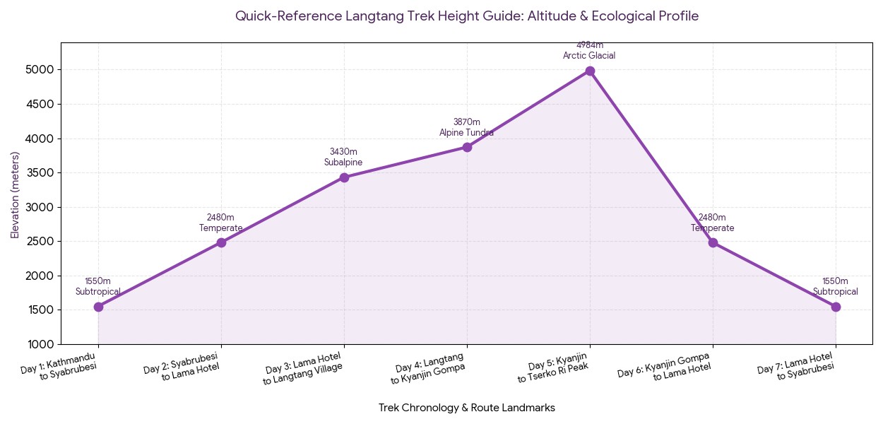
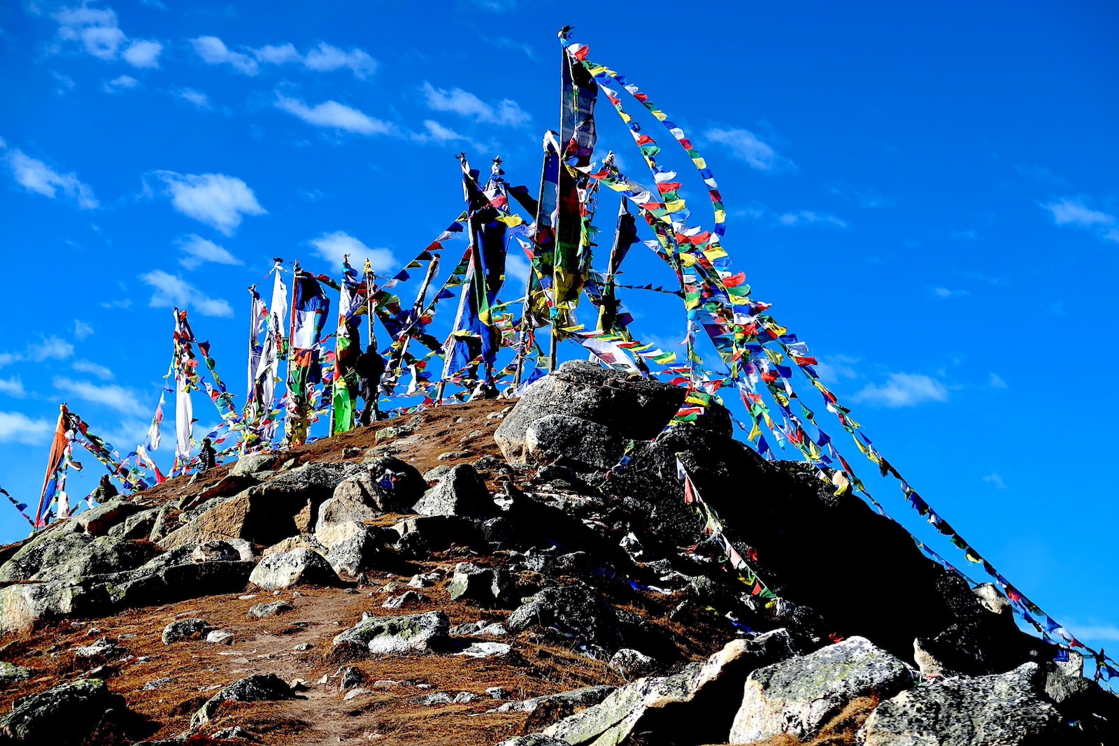
Langtang Valley Trek elevation profile – a scenic Himalayan journey from forested valleys to spectacular high-altitude viewpoints above 4,900 meters.
Day | Main Route Landmark
Present Altitude | Present Height
Dominant ecological zone
Day 1 | Overland travel: Kathmandu to Syabrubesi
1,550 m / 5,085 ft
Subtropical foothills
Day 2 | On foot: Syabrubesi to Lama Hotel
2,480 m | 8,136 ft
Temperate rainforest
Day 3 | On foot: Lama Hotel to Langtang village
3,430 m | 11,253 ft
Subalpine pine forest
Day 4 | On foot: Langtang village to Kyanjin Gompa
3,870 m | 12,696 ft
Alpine tundra valley
Day 5 | Day-hike with altitude adjustment: Kyanjin to Tserko Ri peak
4,984 m | 16,351 ft
Arctic glacial area
Day 6 | Quick descending hike: Kyanjin Gompa to Lama Hotel
Actually, your journey into the high mountains of Langtang begins with a scenic, albeit sometimes jarring, overland drive. Departing from the fertile valley floor of Kathmandu, you will wind along precarious mountain roads that cling to the sides of deep river gorges, past thriving agricultural terraced farming. The drive from Kathmandu to Syabrubesi takes approximately 7-8 hours along rough, mostly unpaved road, but arriving at the trailhead is stepping into a totally different world of thin, clean air and distant, icy Tibetan peaks.
Syabrubesi – the starting point of the Langtang Valley adventure, where roads end and trekking into the Himalayas begins.
Upon arriving in the busy starting town, all hikers will need to briefly stop at the Langtang National Park entrance check-point to purchase their park permits. Once they've been verified, you can check into a local teahouse or lodge. With a humble Syabrubesi elevation of 1,550 meters (5,085 ft), the town provides a calm and non-intimidating base camp; spending your first night below the threshold of altitude sickness allows you to recover and build your strength while allowing your lungs and body to fully adapt to being at altitude
Top benefits of starting in Syabrubes :
No internal flight nerves: Because you are driving to your trek instead of flying into a remote mountain strip like Lukla, you completely avoid any inner ear disturbance due to the pressure change at the very first day of travel.
A low-altitude muscular tune-up: Staying your first night at 1,550m means you can easily process a substantial carb meal before you start on day two, giving your muscles all the fuel they need without being out of breath.
Protected environment: The small trading village of Syabrubesi lies at the conjunction of the Bhote Kosi and Langtang rivers and is protected by the surrounding hills from the harsh mountain wind which will come later in your journey.
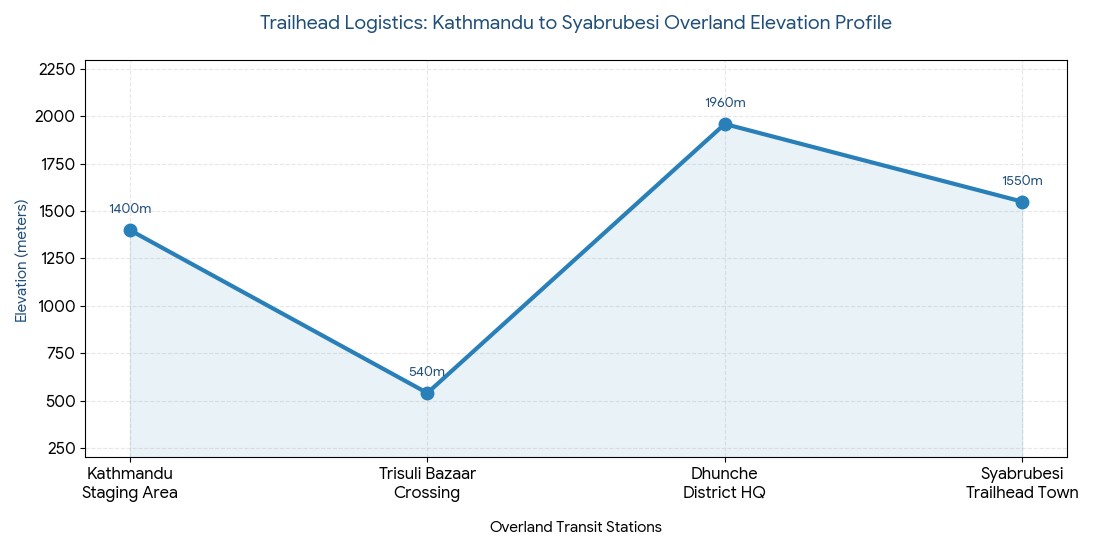
Trail logistic
Elevation Metric | Elevation Imperial
Path detail and why it's important
Kathmandu Staging Area
1,400 m | 4,593 ft
The city valley launching point where packing is finalized.
Trisuli Bazaar Crossing
540 m | 1,771 ft
The lowest point on the route, where you'll find a more tropical environment.
Dhunche District HQ
1,960 m | 6,430 ft
Highest point on the road; also where the military check-point is situated.
Syabrubesi Trailhead Town
1,550 m | 5,085 ft
The Trail Launching point where you'll rest for the night.
Trailhead metrics and elevation data :
Expert Altitude Guidance: Always remember to Climb high, sleep low. This means that during your acclimatization hikes, you'll go up to higher elevations, and then descend to a lower altitude for your overnight stay to allow your body to recover and adjust effectively.
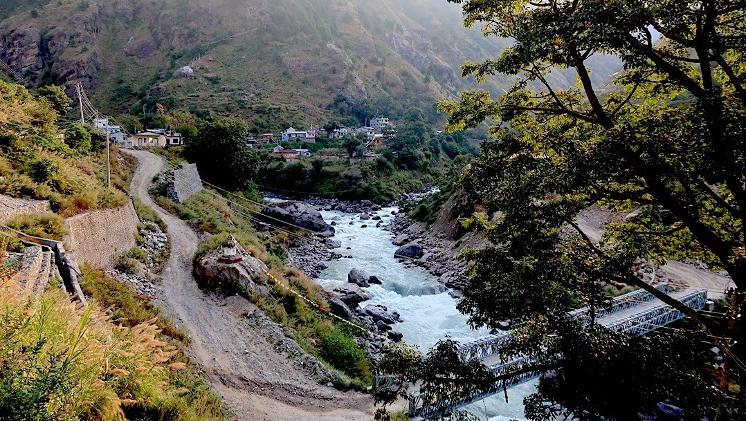
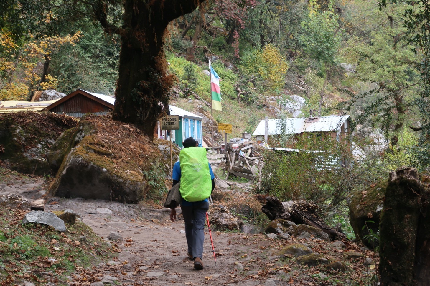
Hiking the Bhote Koshi and Langtang Khola Gorges to Lama Hotel
Here, your first official day of putting boot to trail takes you deep into a primordial wilderness-a beautiful, muscle-burning trek to the forested foothills of Lama Hotel. From the moment you cross the suspension bridge over the Bhote Koshi and begin trekking along the roaring Langtang Khola, the path is essentially a vertical ascent river trail that forces you to climb steadily along the floor of a sheer, deep-cut rock canyon.
Lama Hotel – a peaceful forest rest stop on the way up the beautiful Langtang Valley Trek.
Throughout this grinding ascent, the air is heavy with moisture and the roar of waterfalls tumbling down the canyon walls. You’ll scramble across swinging suspension bridges, navigate slick stone steps, and walk beneath massive granite overhangs as the path zigzags upriver. Given that this challenging first day requires nearly a thousand meters of daily elevation gain, it provides the ultimate wake-up call to your legs and lungs.
Jungle Canopy Filter: In the lower elevations of the trek, you’ll wind directly through dense, moss-draped bamboo and oak forests that shield you from the valley’s high humidity and humid sun.
Canopy wildlife: With careful, quiet hiking, you have a good chance of spotting wild Langtang langurs leaping from tree limb to tree limb within the protected ecosystem of the national park.
Rimche incline surge: Your climb intensifies dramatically in the final hour with a series of steep, exposed rock switchbacks that ascend sharply from the riverbed level up to the high ridgeline above Rimche.
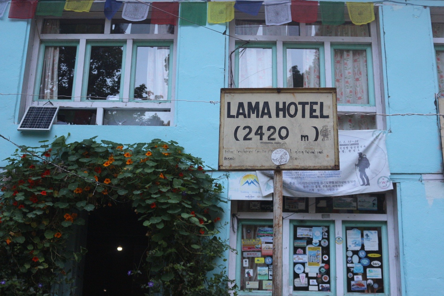
Arrival at forest clearing: Your day concludes as you enter Lama Hotel, a small collection of wood and stone teahouses tucked away in a tranquil forest clearing.
Syabrubesi to Lama Hotel – a gradual climb through lush forests and river valleys into the heart of Langtang.
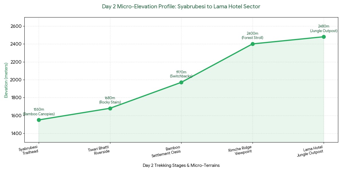
Trail Station / Landmark
Baseline Elevation (m) | Baseline Elevation (ft)
Height Gain from Last Station | Key Terrain Characteristics
Syabrubesi Bridge
1,550m | 5,085ft
Start Point | Rocky dirt tracks; wide valley floor; humid conditions.
Tiwari Bhatti
1,680m | 5,511ft
+130m | Mostly flat; trail hugging the fast-flowing river.
Bamboo Settlement
1,970m | 6,463ft
+290m | Dense bamboo canopy; steep stone steps emerge.
Rimche Ridge
2,400m | 7,874ft
+430m | Steep, switchbacking rock trail; intense climbing section.
Lama Hotel Outpost
2,480m | 8,136ft
+80m | Small clearing; deep forest; cool evening air.
Milestone Grid: Syabrubesi to Lama Hotel
Performance Indicator
Daily Metric
Trekker Advice
Total Horizontal Distance
11.5km (7.1mi)
Focus on a steady, mechanical pace; resist urge to sprint the initial flats.
Net Vertical Elevation Gain
+930 vertical meters
Use trekking poles to offload ~20% of the burden from your knees.
Estimated Trekking Time
5.5-6.5 Hours
Carry ample lightweight, fast-burning carbohydrates for an energy boost.
Daily Energy and Effort Metrics :
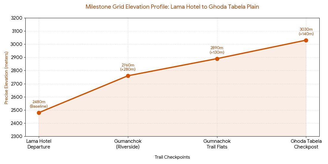
Shifting to Alpine Woodlands: Trail from Lama Hotel to Riverside and Ghoda Tabela
Actually, you’ll wake up to a distinct shift in the morning air at Lama Hotel as you begin to climb higher into the valley. The humid jungle gives way to a beautiful transitional zone as the oak and bamboo trees begin to thin out and are gradually replaced by expansive groves of subalpine hemlock, larch and large rhododendrons.
Riverside forest trail in Langtang Valley – where nature, river sounds, and lush greenery make every step magical.
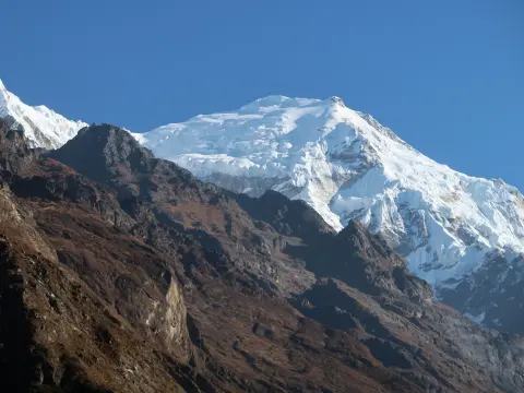
As you walk past the picturesque Riverside tea houses, the gorge starts to open up and the roaring sound of the Langtang Khola recedes as the valley walls grow wider, revealing the first glimpse of the enormous snow-capped peaks of Langtang Lirung (7,234m) against the northern sky.
Crossing the Thinning Air Threshold :
Microclimate cooling: By the time you break through the 2,800m mark, the humid valley air has completely vanished and been replaced by a crisp, dry, and cool alpine atmosphere.
Entering the Gateway plain: When you arrive at Ghoda Tabela, you'll walk onto a wide-open plain that was once an official horse-breeding ground for regional traders.
Physiological threshold: Reaching the Ghoda Tabela altitude of 3,030 meters (~9,941 feet) represents the crucial thinning air threshold where your body’s lungs must begin to adapt to lower oxygen levels.
Strategic clothing change: Because the open plains are so exposed to strong mountain winds, this is the point where trekkers should pack away their lighter shorts and replace them with warm, windproof layers.
+130m | Pine and hemlock woods dominate; wider, drier trail bed.
Ghoda Tabela Checkpost
3,030m | 9,941ft
+140m | Wide open alpine plain; check-in point for military permits.
Milestone Grid: Lama Hotel to Ghoda Tabela Plain
High-Altitude Metric
Value at 3,030m
Physiological Response & Trekking Plan
Effective oxygen density
71%
Expect slightly increased respiratory rate; slow your step rate.
Average Daytime Temperature
10C–14C | (Spring/Autumn)
High UV index; wear sunscreen and polarized sunglasses.
Hydration goal
3.5 Liters minimum
Continue regular drinking to prevent fluid loss due to increased breathing.
Environmental Adaptation Factors :
The expert acclimatization rule: The most crucial rule for trekking safely in high altitudes is "climb high, sleep low". Pushing your body to a higher altitude during your afternoon acclimatization hikes helps your body prepare for thinner air while allowing your body to recover and adapt by sleeping at a lower elevation.
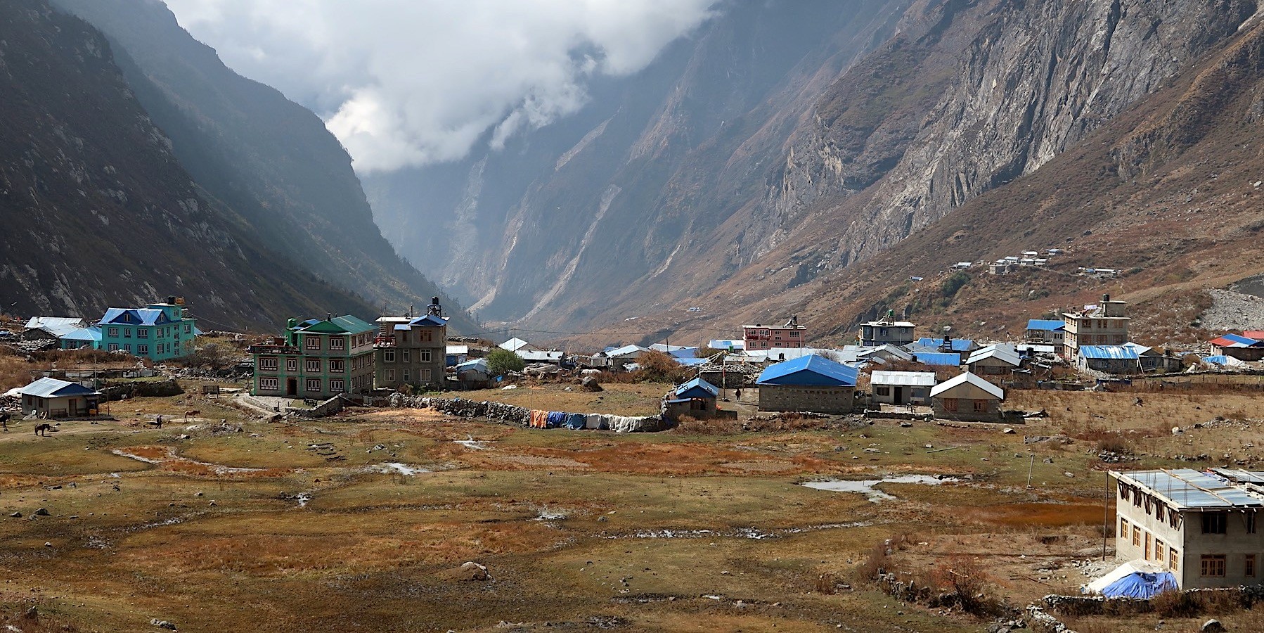
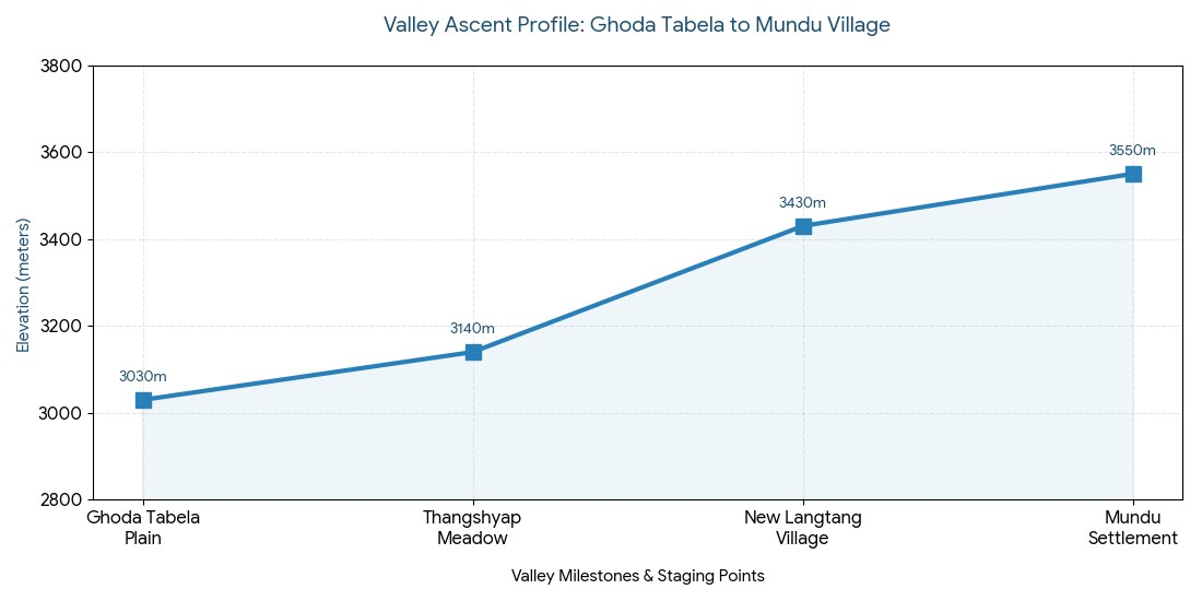
Moving into the Upper Valley: Reaching Mundu and New Langtang Village
Beyond Ghoda Tabela’s alpine meadows, the trail dips out of the narrow river gorge and begins its long, dramatic rise out onto the wide valley floor. As the terrain opens, the thick forests give way completely to an alpine landscape characterized by short juniper bushes, dry shrubs, and stony yak pastures.
Langtang Village – a beautiful mountain settlement blending culture, resilience, and breathtaking Himalayan scenery.
Likewise, you’ll trek past long, prayer-carved stone walls and colorful fluttering prayer flags that catch the crisp mountain breeze. This stretch marks your entry into the Tamang homeland at high altitude, as the immense sky opens up above you to frame the jaw-dropping northern ranges of the Langtang Himal.
[Ghoda Tabela Plain: 3,030 m]- (Pastoral Stone Gateways)
[Thangshyap Meadow Stop: 3,140 m]- (The Glacial Debris Path)
[Langtang Avalanche Memorial Site: 3,400 m]- (The Rebuilt Settlement Floor)
[New Langtang Village Hub: 3,430 m]- (The Upper Valley Plateau)
[Mundu Village Enclave: 3,550 m]
Navigating the Upper Valley Terrain :
Entering Sacred Space: The trail starts following the edges of large stone walls. Walk to the left of any mani walls encountered, a sign of respect in Buddhist culture.
Glacial Valley Opens Up: The mountains draw back to reveal the enormous u-shaped valley sculpted by the ancient Langtang glacier over millennia.
Respecting the Slide Base: The trail passes through a solemn landscape of gray rock and glacial debris where an entire mountain collapsed during the devastating 2015 earthquake.
Reaching the Settlement: Past the memorial site you will reach the rebuilt lodges of Langtang Village, and then continue just a bit further up the valley to overnight in the tranquil village of Mundu.
Trail Station / Landmark
Baseline Altitude (Meters) / (Feet)
Height Gain From Last Station | Landscape & Cultural Features
Ghoda Tabela Plain
3,030 m / 9,941 ft
Start Point | Open pastures; military post; wind-exposed trails.
Thangshyap Meadow
3,140 m / 10,301 ft
+110 m | Small cluster of stone teahouses; potato fields.
New Langtang Village
3,430 m / 11,253 ft
+290 m | Main valley hub; completely rebuilt modern lodges.
Mundu Settlement
3,550 m / 11,647 ft
+120 m | Traditional stone houses; spectacular peak views.
Milestone Grid: Ghoda Tabela to Mundu Village :
Honoring the Langtang Avalanche Memorial Site
Actually, the geography of the upper valley holds a heartbreaking reminder of Himalayan history, a place that every trekker will pass. The devastating 7.8 magnitude earthquake in April 2015 triggered a catastrophic ice avalanche on the peaks of Langtang Lirung directly overhead. Millions of tons of ice and rock fractured off the mountainside, creating a blast wave that buried the original historic settlement in tons of debris.
Likewise, trekking across the quiet, gray field of rocks and glacial debris at the Langtang avalanche memorial site is a moving experience. The memorial wall bearing the names of those lost-locals, guides, and international trekkers alike-is a solemn tribute. Just beyond this somber expanse, the community's incredible resilience is on full display at the modern, colorful lodges of New Langtang Village, rebuilt on a more secure spot away from the original slide path.
The Glacial Amphitheater Outpost: Settling into Kyanjin Gompa
Actually, the last leg of the valley trek brings you to the ultimate prize. Leaving the Mundu village elevation behind, you’ll climb gently across glacial outwash plains and through moraines. As you crest a high ridge that flanks the valley, you’ll be met with the breathtaking sight of a magnificent glacial amphitheater. Colorful rooftops nestle at the base of colossal peaks, welcoming you to a legendary high-altitude village.
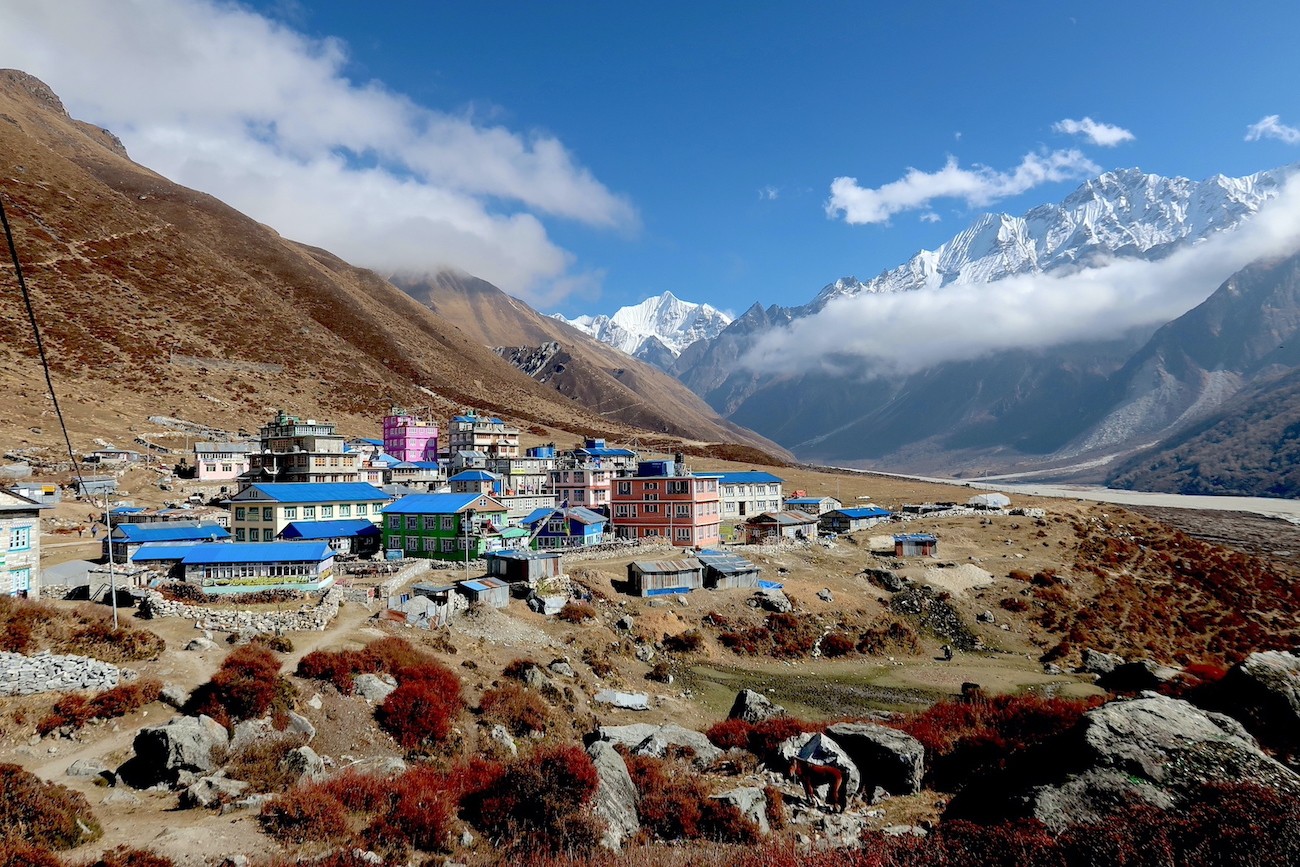
Kyanjin Gompa – the spiritual heart of Langtang Valley, surrounded by majestic Himalayan peaks and peaceful mountain landscapes.
Here, perched at an Kyanjin Gompa elevation of 3,870 meters (approx. 12,696 feet), this vibrant settlement is your ultimate base camp outpost. You are completely surrounded by giants like Langtang Lirung (7,234 m), Ganjala Peak (5,675 m), and Kyanjin Ri (4,773 m). You can even hear the distant thunder of avalanches crashing down the active icefalls from the comfort of your teahouse.
Highlights of the High-Altitude Sanctuary :
The Ancient Monastery: The village is named for the ancient Kyanjin monastery, a tranquil spiritual retreat that has weathered centuries of Himalayan weather.
Taste of Alpine Yak Cheese: Visit Langtang cheese factory for a taste of delicious, high-protein cheese made from pure yak milk. It was established with Swiss help in 1955.
The Ultimate Trekking Base: Because the trailheads for most of the significant side-peak climbs begin here, you can choose to stay in the same lodge for several nights.
High-Altitude Landmark
Elevation Metric / Elevation Imperial
Connective Terrain Dynamic & Significance
Mundu Trailhead Exit
3,550 m / 11,647 ft
The final lowland check point before the upper plateau climb.
Kyanjin Gompa Hub
3,870 m / 12,696 ft
The Central Alpine Base; home to the local cheese factory and lodges.
Kyanjin Ri Lower Peak
4,300 m / 14,107 ft
The nearest acclimatization ridge; a great, easy morning hike.
Tserko Ri High Summit
4,984 m / 16,351 ft
The highest point of the trek; offers incredible panoramic glacial views.
Settlement Elevation and Logistics Metrics :
Environmental Safety Factor
Metric Value at 3,870m
Physiological Response & Trail Protocol
Effective Oxygen Density
Approximately 63%
Air is thin; avoid sudden, jarring movements.
Freezing Point Baseline
0C to -8C (Nighttime)
Temperatures plummet after sunset; don warm clothing immediately.
Daily Acclimatization Rest
48 Hours Minimum
Spend at least two full days at this altitude before tackling summits.
Critical High-Altitude Health Trackers :
The High-Altitude Fuel Rule: When you pass 3,500 meters, your body's metabolism kicks into high gear to cope with the lack of oxygen. It burns through carbohydrates rapidly, even when you're resting. Keep your energy levels up with hot, easily digestible starch meals such as Dal Bhat (lentils and rice), garlic soup (good for circulation), and abundant hot drinks. Stick clear of heavy meats or alcohol, both of which can make your digestive system work harder and mimic the symptoms of altitude sickness like dehydration.
Strategic Adaptation: Why Kyanjin Gompa is the Vital Acclimatization Hub
Stepping into the vibrant, high-altitude outpost of Kyanjin Gompa is a feeling of achievement-but it is here where your vertical discipline meets its ultimate challenge. Because the Langtang trail progresses vertically at a brisk pace, ascending rapidly from lowland riverbeds, your body only has forty-eight hours to adapt to a changing barometric pressure. Sleeping at the Kyanjin Gompa elevation of 3,870 meters (~12,696 feet) puts you right at the cusp of the high-alpine zone where available oxygen drops to a measly 63% of sea-level value.
[Day Climb: Kyanjin Ri / Tserko Ri Ridge] Expose lungs to 4,300m - 4,984m- (Natural Biological Trigger: EPO Surge)- [Shock System for 1-2 Hours]
(The Descent Recovery)- [Sleep Baseline: Kyanjin Gompa: 3,870 m] Sleep soundly with rich recovery
Likewise, any attempts to continue up the valley walls without a structured Langtang acclimatization day strategy will almost certainly result in immediate physiological distress. As your brain registers the blood's diminished oxygen supply, omitting a dedicated adaptation rest period will quickly trigger classic altitude sickness symptoms. To sidestep these initial warning signs and prevent premature trip termination, actively employ day climbs to trigger your circulatory system before settling down for another chilly night in the valley floor.
Implementing the Adaptation Protocol :
The Active Exposure Rule: To practice the hike high sleep low rule, intentionally ascend onto the surrounding high ridges in daylight and then descend to sleep in the valley floor, ensuring lung exposure to thinning air.
Natural Blood Optimization: Just 1-2 hours at altitude will trigger your kidneys to start producing EPO, a signal that instantly initiates the generation of more oxygen-carrying red blood cells.
The Hydration Standard: The arid air of the alpine region will hasten fluid loss with each breath. Maintain your blood pH balance by drinking 4+ liters of pure water per day.
The Energy Conservation Rule: Avoid abrupt, powerful movements upon your first afternoon; keep steps deliberate and coordinated to protect your nervous system.
Staging Target Point
Target Elevation (Meters) / (Feet)
Biological Function & Strategy
Kyanjin Lodge Floor
3,870 m | 12,696 ft
Baseline sleeping elevation; focus on heavy hydration and warm rest.
Langtang Lirung Base
4,200 m | 13,779 ft
Low-impact moraine walk; ideal for testing early lung expansion.
Maximum altitude exposure; ideal preparation for high Himalayan pass routes.
Acclimatization Excursion Framework from Kyanjin Hub :
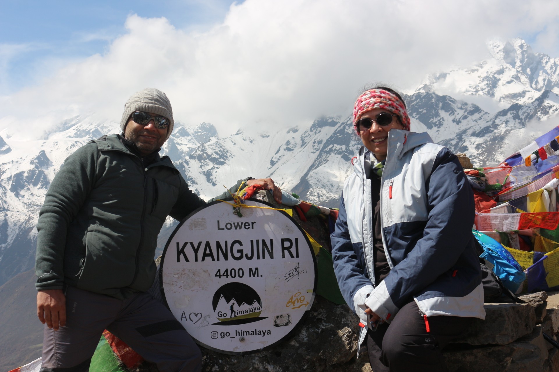
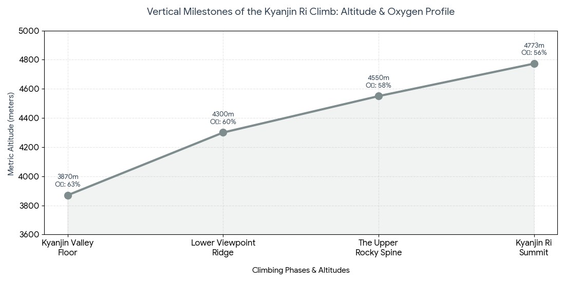
Scaling the First Major Viewpoint Peak: The Ascent of Kyanjin Ri
If your body is feeling comfortable and hydrated after an initial night at the valley floor outpost, the most effective next step in your acclimatization protocol is to tackle the striking black ridge directly behind the village houses. This strenuous, yet rewarding, day hike from Kyanjin Gompa acts as a steep, challenging natural stairway leading you directly to a magnificent vantage point of the upper ice fields.
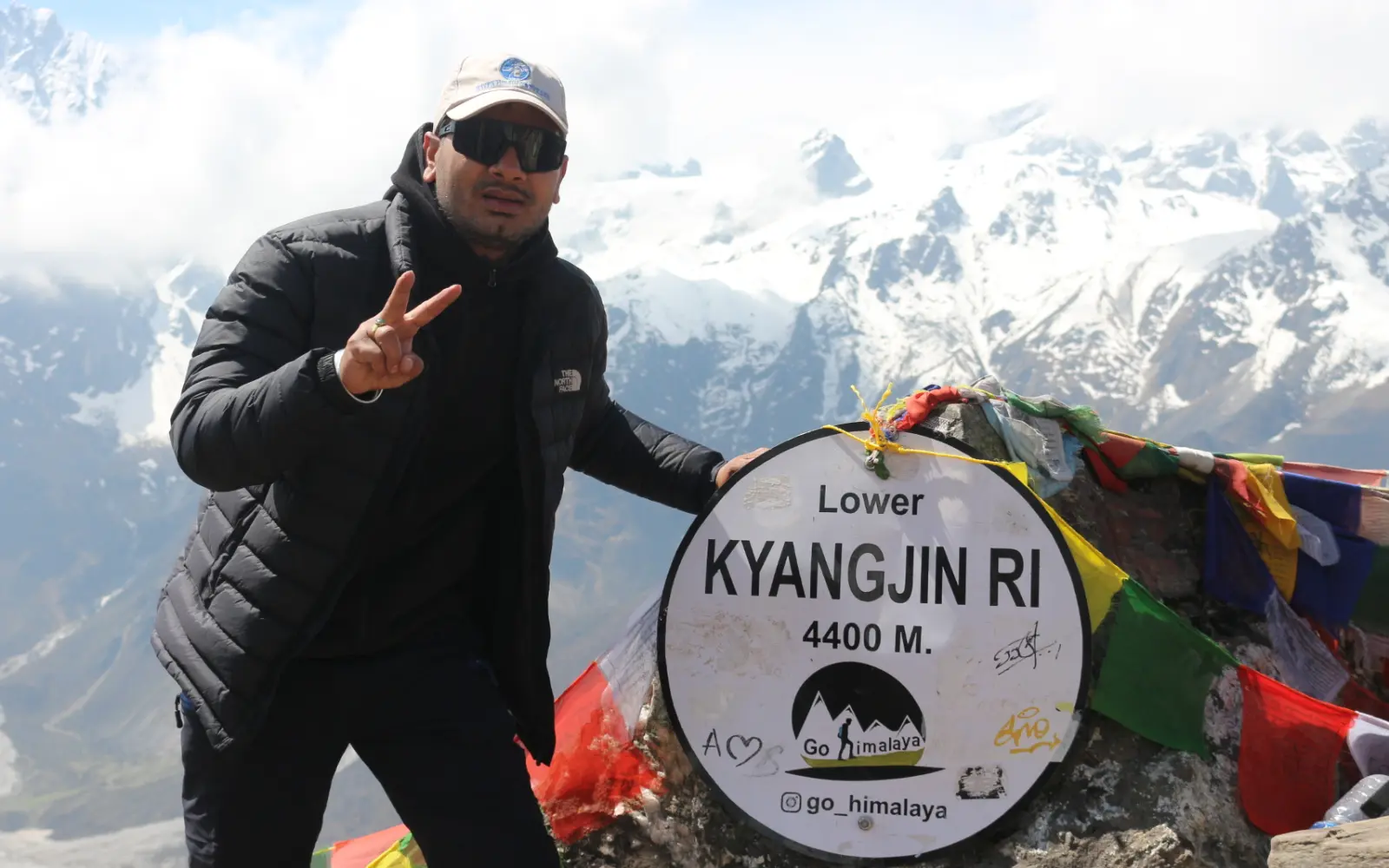
Kyanjin Ri summit – trekkers rewarded with one of the best panoramic views in Langtang Valley.
Here, the trail begins right on the edge of the village meadows, immediately launching onto a steep, narrow dirt path winding upwards via tight switchbacks. As the ascent is entirely vertical, developing a slow, steady breathing pattern is absolutely crucial to ward off early fatigue. The path is broken into two main milestones, allowing hikers to determine their maximum ascent point based on current energy levels and blood oxygen readings.
Conquering the Twin Summit Ridges :
The Lower Viewpoint Marker: After two hours of continuous, punishing uphill trekking from the trailhead, you will reach a prominent lower prayer flag viewpoint at an altitude of 4,300 meters (~14,107 feet).
The Ultimate Ridge Scramble: Those pursuing the full ascent will continue up the rugged crest for another hour, culminating at a Kala Patthar-style apex at a Kyanjin Ri height of 4,773 meters (15,659 feet).
The Glacial Wall Panorama: At the panoramic peak elevation 4773m milestone, you will have an unparalleled view directly across from the colossal, overhanging ice walls of Langtang Lirung ($7,234\text{ m}$), looking straight down into the roaring icefalls below.
The Safe Descent Loop: After spending 20 minutes at the peak absorbing the immense views and allowing your system to adjust to the thinner air, you will descend via a winding, less-steep loop trail, arriving back at your lodge for a much-needed hot lunch.
56% | The Apex Peak; marked with prayer flags; sub-zero drafts.
Vertical Milestones of the Kyanjin Ri Climb :
The Fueling for the Altitude Rule: Above 3,500 meters, your metabolism elevates significantly in an attempt to compensate for lower oxygen levels and will burn carbohydrates at an accelerated pace even during rest. To keep your energy reserves full, consume 3 hot, simple carbohydrate meals per day like Dal Bhat (lentils and rice), garlic soup for increased blood flow, and plenty of hot beverages. Avoid heavier meats or alcohol, as they increase digestive stress and can exacerbate altitude sickness symptoms.
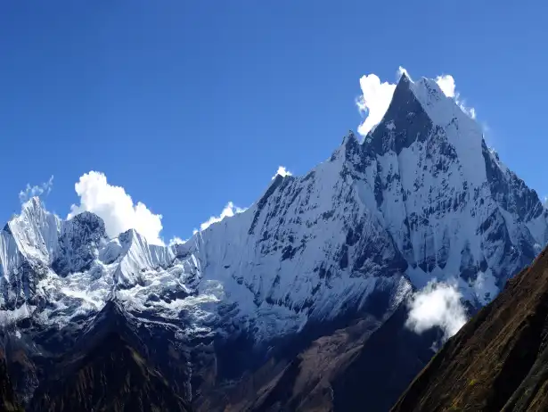
Scaling the Summit: Reaching the Apex at Tserko Ri
Actually, this is the expedition's peak physical trial, as you set off to reach the highest point of the valley. A climb to this windswept, rocky outpost means departing Kyanjin Gompa before sunrise at 5:00 AM, into the freezing pre-dawn, under a sky full of sharp, clear stars. Early starts ensure stable footing on frozen trails, and guarantee views from the summit before the afternoon fog sets in.
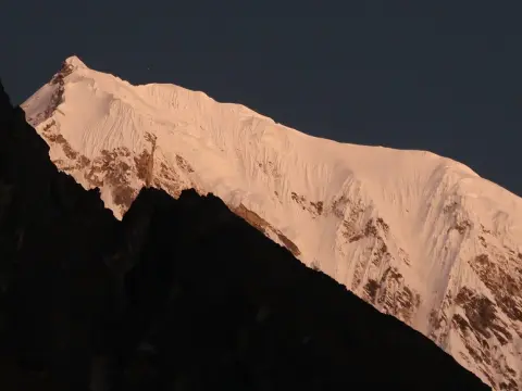
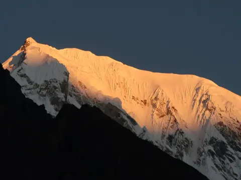
Tserko Ri summit – one of the highest viewpoints in Langtang Valley, offering a breathtaking 360° Himalayan panorama
[Kyanjin Valley Floor: 3,870 m]- ( Pre-Dawn River Bed Traverse)- [Glacial Stream Crossings ]- ( Steep Moraine Grind )- [The Loose Scree Switchbacks]- ( The Final Boulder Scramble)
[Tserko Ri Summit: 4,984 m] Highest point on the trek (54% Sea-Level Oxygen )
Attempting this tough, high alpine ridge-climb, your strength and determination will be challenged. The trek crosses the dry glacial stream bed before beginning the punishing, steep side of a wind-blasted ridge. Ascending to the Tserko Ri height 4,984 m (16,351 feet), the path turns to a steep, technical scramble across huge, slippery boulder field formations and scree.
Actually, the highest point on Langtang trek, adorned with thousands of colorful prayer flags, offers unparalleled, panoramic views across the entire Central Himalayas. You'll be able to witness the towering beauty of Langtang Lirung, the slender Yala Peak (5,520 m), the formidable Kimshung (6,500 m), and the monumental white monolith of Shisha Pangma (8,027 m) directly across the Tibetan border.
How to Summit: Maintaining Energy and Well-being,
Controlled Micro-Pacing: Available oxygen will have dropped significantly to just 54% of sea level capacity. Any increase in physical intensity can cause severe discomfort. Step-by-step rhythmic pacing ensures that your heart rate stays below anaerobic thresholds.
Protecting from Cold and Wind: This high alpine ridge is a harsh, windswept region prone to freezing air flowing from the Tibetan plateau. Pack heavy down parkas, insulated wind-resistant clothing, thermal gloves, and balaclavas to stay warm.
Safe Footing and Grip Protocols: The upper snow- dusted or ice-covered slopes and boulder fields make traction an issue. Lightweight spikes on your boots, coupled with careful step placement, will help you maintain balance.
Phase / Altitude Goal
Exact Elevation (m) | Exact Elevation (ft)
Elevation Gain (m) | Oxygen / Air Composition
Kyanjin Base Outpost
3,870 m | 12,696 ft
0 m | 63% Oxygen; sharp pre-dawn alpine air.
Lower Ridge Spine
4,250 m | 13,943 ft
+380 m | 61% Oxygen; entering steep, consistent tracks.
Mid-Way Plateau
4,600 m | 15,091 ft
+350 m | ~58% Oxygen; entering rocky moraine terrain. High wind areas.
Tserko Ri Summit
4,984 m | 16,351 ft
+384 m | ~54% Oxygen; the ultimate alpine vantage point. Sub-zero conditions.
Altitude Mile Markers: From Kyanjin to Tserko Ri Summit :
The Headlong Descent: Plummeting to Lower Elevations
Here, returning from the awe-inspiring peaks, the trek back reveals the valley's incredible physical topography. The classic "in-and-out" structure of the Langtang Valley means that as you depart the snow line, you will begin your journey back towards Lama Hotel, retracing your steps. This design allows for a dramatically fast descent that feels both liberating and utterly exhilarating for the body.
[Tserko Ri Peak: 4,984 m]- (The Summit Departure)
[Kyanjin Gompa: 3,870 m]- (Navigating the Avalanche Field)
[Langtang Village: 3,430 m]- (Shedding the High Altitude Atmosphere )
[Ghoda Tabela Plain: 3,030 m]-(Entering the Dense Forest)
[Lama Hotel Lodge: 2,480 m] Over 1,400 Meters Dropped in a Single Day
A descent of more than 1,400 vertical meters from the higher valley into the dense, tropical rainforest in a single day is a relentless, knee-buckling experience. Your quadriceps will burn as you struggle to control your pace down the rugged switchbacks of gravel, rocks, and scree.
But this dramatic drop in elevation has remarkable benefits for altitude recovery. The higher pressure and increased oxygen content of the atmosphere as you descend restore your muscle tissues, clear your head from any lingering altitude-related discomfort, and lead to a truly deep and restorative night of sleep.
Downhill Strategies: Managing the Descent,
Lower Back and Leg Health: Keep your stride length short to minimize impact, bend your knees to absorb some shock, and use your trekking poles to transfer weight.
Quick Oxygen Re-charge: The Ghoda Tabela plains mark the beginning of a steep descent, and your body begins to benefit from the rapidly increasing atmospheric oxygen. Your resting heart rate will lower, and your muscles will relax.
Adjusting Layers: Since you are transitioning from a freezing, desert-like environment to a humid tropical climate, make sure to remove your thickest down layers at the appropriate point to prevent overheating and excessive sweating.
Target / Milestone
Altitude Drop (m) | Altitude Drop (ft)
Net Descent (m) | Air & Landscape
Kyanjin Departure
3,870 m | 12,696 ft
0 m | Sharp pre-dawn alpine air; open valley vistas.
New Langtang Village
3,430 m | 11,253 ft
440 m | The rocky grazing village; sub-alpine tundra landscape.
Ghoda Tabela Plain
3,030 m | 9,941 ft
400 m | Approaching tree line; reducing wind impact.
Riverside Tea Houses
2,760 m | 9,055 ft
270 m | Deep temperate forest; hemlock and oak tree cover.
Fast Recovery Benefit: A wonderful safety factor inherent in the Langtang Valley's physical topography is that the trail serves as a built-in emergency descent route. Because it's a consistent, direct corridor, if you experience even mild altitude-related symptoms at Kyanjin Gompa, descending a short distance below Ghoda Tabela can effect a rapid biological fix. The dense, oxygen-rich air within the lower river gorge immediately mitigates mild altitude sickness, making this a very forgiving route for less-experienced trekkers.
Trekking safely in thin air: AMS and Emergency Plan
Actually, trekking in the shadow of the world’s highest mountains will surely be an experience unlike any other but requires absolute reverence for invisible changes in atmospheric pressure. As you hike up the valley, air becomes thinner, so with every single breath that you take, your blood will have less and less oxygen. This might result in high altitude sickness in the long run and that you might not know.
To make your trek safer; every trekker is advised to keep close look on basic vital signs of health. Early identification of symptoms of acute mountain sickness and to decide whether it's time to leave usual trekking routine and implement contingency plan may make all the difference between successful and life threatening journey on the mountain.
Checklist for Safety and Survival in High Altitude
Look out for early signs: Early signs of AMS resemble a hangover. Intense pulsing headaches together with fatigue, dizziness, lack of appetite and difficulty sleeping are symptoms that you're body is already complaining. Therefore, continue to climb no more from the first symptom.
Fluid intake and nutrition: drink between 4 to 5 liters of clean, filtered water daily. Thin air due to faster and deeper respiration will dehydrate lungs and hasten your body’s dehydration, which mimic and worsens AMS symptoms.
Consider Diamox in Langtang: Ask your physician for Acetazolamide (Diamox). This drug makes your kidneys excrete bicarbonate in blood, which leads to acidified blood and stimulates brain to breathe faster, speeding up your body's natural adaptation process. This drug is very effective in both pre-preventing altitude sickness when taken before ascending over 3000m and in curing initial AMS symptoms.
Red flag for acute cases: The group member suffering from chronic, relentless cough, blood-colored frothy spittle, breathing difficulty when at rest (HAPE symptoms), or inability to stand and walk straight (HACE symptoms), must be evacuated to lower altitude immediately. Don't delay your departure or wait for a rescue helicopter until the sun rises.
Safety measures for helicopter evacuation: In cases of severely ill trekkers or injuries, use satellite or Garmin In Reach phone to alert rescue helicopter. Helicopter landing is always dependent on the visibility and stability of winds in high mountains. Due to rapid changes of the weather in the higher valley you have to move the victim to lower safe zone if helicopter landing is not possible.
Total Altitude Gain During Langtang Valley Trek
Finding the Total Accumulated Altitude Gain for the Langtang Valley Trek-meaning, all the upward segments totaled together-involves a bit more calculation than simply noting your start and end points. Because the route constantly dips down to cross suspension river bridges and then climbs steeply back up again over cliff faces and along ridge lines, the true total vertical distance you'll climb will be much higher than the difference in map elevation.
Below is an exact breakdown of the cumulative elevation gain for both the basic path and the extra ascents to acclimatization peaks.
1. Standard Langtang Valley Trek: Syabrubesi to Kyanjin Gompa This tracks the main 'in-and-out' route, following the Langtang Khola (river) valley up to the main hub, excluding optional mountain climbs.
Starting Elevation (Syabrubesi): 1,550 m 5,085 ft
Maximum sleeping elevation (Kyanjin Gompa): 3,870 m 12,696 ft
Net change in elevation: 2,320m 7,611 ft
Total accumulated altitude gain: ~2,650 m (8,694 ft)
(This estimate accounts for about 330 m of small climbs over small ridges, riverbanks, and landslide areas along the way up).
2. Peak Additions (Acclimatization)
Once at the village, most trekkers choose to climb one or both of the famous viewpoints above Kyanjin Gompa for practice and panoramic vistas.
Ri Climb: adds +903 m (+2,963 ft) vertical from the lodge floor to the summit at 4,773 m.
Tserko Ri climb: adds +1,114 m (+3,655 ft) of steep, higher-altitude climbing from the valley floor to the summit at $4,984\text{ m}$.
Trekking itinerary range
Total cumulative elevation gain (meters)
Total cumulative elevation gain (feet)
Basic Valley Trek only (Syabrubesi to Kyanjin Gompa and back)
2,650 m
8,694 ft
Valley Trek plus Kyanjin Ri climb (A common itinerary for acclimatization)
3,553 m
11,657 ft
Peak-bagger's route (Valley trek plus Kyanjin Ri and Tserko Ri climbs)
4,667 m
15,312 ft
Your total elevation gain:
So, depending on what your chosen itinerary looks like and whether you are the type who like to climb high to improve acclimatization, your total cumulative vertical distance will be one of the following:
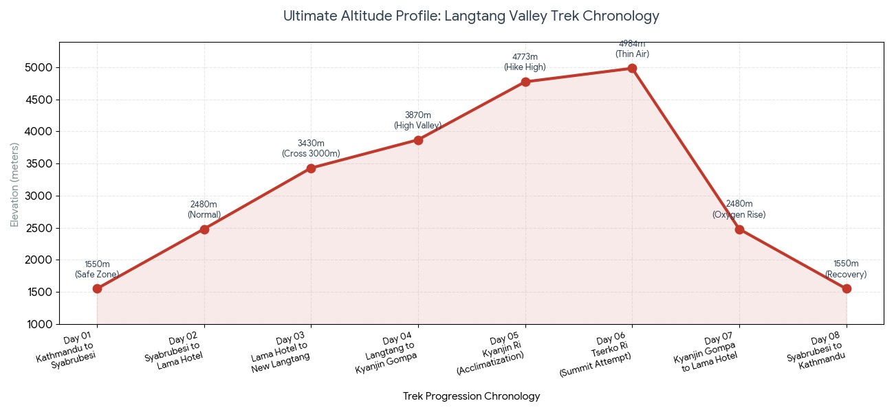
Conclusion: Comprehensive altitude map of Langtang valley trekking
Actually, Langtang Valley trek is the perfect destination to those who wish to venture into the alpine region of Nepal but don't have enough time or are looking for a relatively shorter trek in the Himalayas. Due to the rapid ascent the map of daily elevation gains will be your most essential tool for trekking safely and making a successful itinerary.
By reviewing the Langtang valley daily altitude chart, you can envision the vertical mile markers of the entire trekking route and know precisely where to ascend slower and make important rest days. If you are on a leisure, slow trek, or considering the short trek itinerary Nepal offers for shorter trips, thoughtful pacing and proper acclimatization can allow you to experience the raw grandeur of the Himalayas comfortably.
Itinerary day
Trekking day stages/destination | Daily altitude (m) / (ft)
Normal trek time | Risk profile and adaptation stages
Day 01
Drive from Kathmandu to Syabrubesi | 1,550 m | 5,085 ft
7-8 hours (Drive) | Safe zone: no risk of AMS.
Day 02
Trek from Syabrubesi to Lama Hotel | 2,480 m | 8,136 ft
5-6 hours | Dense jungle air; normal training with increased effort.
Day 03
Trek from Lama Hotel to New Langtang Village | 3,430 m | 11,253 ft
5-6 hours | Crossing the 3000m line; take a slower approach.
Day 04
Trek from Langtang village to Kyanjin Gompa | 3,870 m | 12,696 ft
3-4 hours | The high valley floor reached.
Day 05
Resting/ acclimatization day and exploration hike | 4,773 m | 15,659 ft
4-5 hours | Day hike to Kyanjin Ri; Hike High Sleep Low principle.
Day 06
Summit attempt to Tserko Ri peak | 4,984 m | 16,351 ft
7-8 hours | Highest point on Langtang trek; the air is thin here.
Day 07
Descend from Kyanjin Gompa to Lama Hotel | 2,480 m | 8,136 ft
6-7 hours | Significant drop in altitude; instant oxygen increase.
Day 08
Walk to Syabrubesi, drive to Kathmandu | 1,550 m | 5,085 ft
Ultimate altitude map and data table for Langtang Valley Trek :
Things that matter in the trip:
Bring a reliable Oximeter: To keep the track of blood oxygen levels every morning and night while in the tea house and monitor your adaptation process.
Stick to sensible altitude limits: Don't increase altitude by more than 500 meters overnight above 3000 m.
Ensure good trekking insurance coverage: Make sure that your trekking insurance covers altitude and helicopter rescue up to 5000 m.
Carry a powerful headlamp: Essential for the frigid dawn trek to the peak of Tserko Ri; remember to pack extra lithium batteries for your headlamp.
Langtang Valley Trek- FAQs
1. What is the starting point and elevation of the Langtang Valley trek? The classic Langtang Valley trek elevation profile officially begins in the lively trail town of Syabrubesi, situated at an altitude of 1,550 meters (5,085 feet). This relatively low starting altitude is highly beneficial for beginners, allowing for a gentle first day of walking through verdant, low-altitude forests.
2. What is the maximum elevation reached on the standard Langtang Valley trek? The highest overnight altitude on a standard Langtang Valley trek itinerary is 3,870 meters (12,696 feet) at the beautiful alpine village of Kyanjin Gompa. This is the final inhabited base lodge settlement on the main trek route before you begin your descent back down the valley.
3. How high can you climb on Langtang Valley trek side excursions? While the main trail concludes at Kyanjin Gompa, your maximum Langtang Valley trek elevation can actually reach much higher with side excursions, primarily as optional day hikes for acclimatization. Many trekkers ascend the stunning viewpoint peaks of Kyanjin Ri (4,773m) or the more strenuous Tserko Ri (4,985m).
4. What is the total Langtang Valley trek distance covered across this altitude profile? The entire round-trip Langtang Valley trek distance on foot is roughly 65 to 80 kilometers (40 to 50 miles), depending on which side hikes you opt to incorporate within the upper glacier basin.
5. Is the Langtang Valley trek elevation profile suitable for beginners? Absolutely. The steady gradient of the Langtang Valley trek elevation profile makes it one of the most beginner-friendly alpine treks in Nepal. It progresses more gradually than routes like Everest Base Camp, significantly minimizing the overall Langtang Valley trek difficulty for inexperienced trekkers.
6. What is the elevation of Lama Hotel and why is it a key stop? Lama Hotel is perched at an altitude of 2,470 meters (8,103 feet) and serves as an essential overnight stop on any safe Langtang Valley trek itinerary. This is because it marks the culmination of a lengthy, sustained vertical climb of approximately 900 meters from Syabrubesi, allowing your body to safely rest below the 3,000-meter mark.
7. How rapid is the altitude variation on the day you hike to Langtang Village? The trek from Lama Hotel (2,470m) to Langtang Village (3,430m) involves a substantial altitude change of 960 vertical meters. This day's hike crosses the critical 3,000-meter threshold, and your guide will therefore enforce a slow and steady pace to help manage the increasing Langtang Valley trek difficulty.
8. What is the current elevation of the rebuilt Langtang Village? The rebuilt Langtang Village now sits at an elevation of 3,430 meters (11,253 feet). Following the devastating earthquake in 2015, this vibrant, traditional Tamang village was reconstructed slightly higher up the valley wall to ensure safety and provide a strategically positioned resting point for acclimatization.
9. Does the Langtang Valley trek elevation profile pose a high risk for altitude sickness? The risk of Acute Mountain Sickness (AMS) is substantially lower on this trek compared to others at a higher altitude. As the peak overnight Langtang Valley trek elevation does not exceed 4,000 meters, severe altitude illnesses are uncommon, provided you maintain proper hydration and walking pace.
10. What is the altitude variation between Langtang Village and Kyanjin Gompa? The hike from Langtang Village to Kyanjin Gompa is a gentle ascent, climbing from 3,430 meters to 3,870 meters-an altitude change of only 440 vertical meters. This relatively short and scenic morning walk allows your body to comfortable adjust to the higher alpine environment.
11. How does the available oxygen change across the Langtang Valley trek elevation profile? At the starting point in Syabrubesi, you will be breathing with the same oxygen saturation as at sea level. By the time you reach the highest overnight point at Kyanjin Gompa (3,870m), the available oxygen will have dropped to roughly 64%, meaning you will notice shorter breaths during ascents.
12. What is the best strategy to handle the Langtang Valley trek difficulty? The most effective method to overcome the Langtang Valley trek difficulty is to adhere to the "climb high, sleep low" principle. Dedicating an acclimatization day at Kyanjin Gompa (3,870m) to hike up to higher panoramic viewpoints allows your body to safely adapt to the surrounding peaks.
13. How much does a Langtang Valley trek cost in relation to its altitude? A typical Langtang Valley trek cost ranges between $500 and $900 USD per person. Because this altitude profile is accessed by road transportation from Kathmandu rather than expensive internal flights, it remains one of the most budget-friendly alpine treks available in Nepal.
14. What terrain changes can I expect across the Langtang Valley trek elevation profile? The terrain undergoes a significant visual transformation as you ascend. You will begin by trekking through a humid, dense sub-tropical river gorge filled with oak and bamboo forests, which gradually gives way past Ghoda Tabela (3,030m) to a wide, exposed, glacier-carved U-shaped alpine valley.
15. Are there high-altitude mountain passes on a standard Langtang Valley trek itinerary? No, a typical Langtang Valley trek itinerary does not involve crossing any high, technical mountain passes. The trail simply ascends and descends along the main valley floor, avoiding the increased atmospheric and physical challenges associated with high pass crossings.
16. What peaks are visible from the highest points of the Langtang Valley trek elevation profile? From the highest vantage points like Tserko Ri, you will be treated to an incredible, panoramic view. You'll gaze down upon the massive glaciers of Langtang Lirung (7,227m), Yala Peak (5,520m), Gangchempo (6,387m), and even see across the border into Tibet.
17. Is travel insurance mandatory for the Langtang Valley trek elevation? Yes, travel insurance is highly recommended and generally required. Even though the standard trail Langtang Valley trek elevation is lower than treks like Everest Base Camp, your policy should explicitly cover emergency helicopter evacuation up to 5,000 meters to provide for any potential high-altitude emergencies or injuries.
18. How does the altitude profile affect nighttime temperatures on the trek? Nighttime temperatures drop considerably as you climb higher along the Langtang Valley trek elevation profile. While the initial trailheads will be warm, the temperature at Kyanjin Gompa will frequently be below freezing (0°C to -5°C / 32°F to 23°F), necessitating a warm down jacket and a suitable sleeping bag.
19. Can I shorten the Langtang Valley trek distance if I am fit? If you are in excellent physical condition, you can reduce the return Langtang Valley trek distance by jogging from Kyanjin Gompa down to Lama Hotel in one go, an impressive drop of over 1,400 vertical meters. However, it is not advised to rush the initial ascent as your body needs adequate time to adjust to the altitude changes.
20. What is the success rate for beginners facing the Langtang Valley trek difficulty? The overall success rate for the Langtang Valley trek is exceptionally high, hovering around 95%. Due to its gradual Langtang Valley trek elevation profile and relatively lower maximum altitude, the trek is very accessible, with the vast majority of participants completing it successfully.