[{"name":"Everest Base Camp Helicopter Tour","duration":"1","image_url":"https:\/\/www.havenholidaysnepal.com\/storage\/trip-galleries\/1\/thumb_6cd53005d75a86e373d31419d1b14d78.webp","offer_price":1195,"url":"https:\/\/www.havenholidaysnepal.com\/trips\/everest-base-camp-helicopter-tour"},{"name":"Everest Mountain Flight","duration":"1","image_url":"https:\/\/www.havenholidaysnepal.com\/storage\/trip-galleries\/4\/thumb_3b0b4f1d6f72b0ad224daf4752f2c6e0.jpg","offer_price":285,"url":"https:\/\/www.havenholidaysnepal.com\/trips\/everest-mountain-flight"},{"name":"Everest Short Trek","duration":"9","image_url":"https:\/\/www.havenholidaysnepal.com\/storage\/trip-galleries\/5\/thumb_BXPP3621.JPEG0.02033800 1727957098.webp","offer_price":995,"url":"https:\/\/www.havenholidaysnepal.com\/trips\/everest-short-trek"},{"name":"Gokyo Valley Trek","duration":"12","image_url":"https:\/\/www.havenholidaysnepal.com\/storage\/trip-galleries\/6\/thumb_10bc469b14731f23d3ce84a7092ad53f.jpg","offer_price":1195,"url":"https:\/\/www.havenholidaysnepal.com\/trips\/gokyo-valley-trek"},{"name":"15 days Annapurna Base Camp Trek","duration":"15","image_url":"https:\/\/www.havenholidaysnepal.com\/storage\/trip-galleries\/7\/thumb_87d1533bc45faf070990aef0579e4be4.jpg0.81855100 1728285496.webp","offer_price":785,"url":"https:\/\/www.havenholidaysnepal.com\/trips\/15-days-annapurna-base-camp-trek"},{"name":"Nepal Pilgrimage Tour","duration":"14","image_url":"https:\/\/www.havenholidaysnepal.com\/storage\/trip-galleries\/8\/thumb_02c3bcf2ad2e8a4c1703e90ae747b5f1.jpg","offer_price":1475,"url":"https:\/\/www.havenholidaysnepal.com\/trips\/nepal-pilgrimage-tour"},{"name":"UNESCO World Heritage Site Tour","duration":"10","image_url":"https:\/\/www.havenholidaysnepal.com\/storage\/trip-galleries\/9\/thumb_unesco-world-heritage-site-Lumbani-temple-buddhists-hindus-kathmandu-nepal0.36988600 17347617740.93089500 1737469667.webp","offer_price":715,"url":"https:\/\/www.havenholidaysnepal.com\/trips\/unesco-world-heritage-site-tour"},{"name":"Island Peak Climbing","duration":"16","image_url":"https:\/\/www.havenholidaysnepal.com\/storage\/trip-galleries\/11\/thumb_Island peak0.53947000 1734692503.webp","offer_price":2495,"url":"https:\/\/www.havenholidaysnepal.com\/trips\/island-peak-climbing"},{"name":"Upper Mustang Trek","duration":"18","image_url":"https:\/\/www.havenholidaysnepal.com\/storage\/trip-galleries\/12\/thumb_upper mustang 7 Oct-2024.jpg0.95398900 1728286166.webp","offer_price":2995,"url":"https:\/\/www.havenholidaysnepal.com\/trips\/upper-mustang-trek"},{"name":"Annapurna Circuit Trek","duration":"16","image_url":"https:\/\/www.havenholidaysnepal.com\/storage\/trip-galleries\/15\/thumb_tibetan-flags.jpg0.04843900 1728289138.webp","offer_price":985,"url":"https:\/\/www.havenholidaysnepal.com\/trips\/annapurna-circuit-trek"},{"name":"Gosainkunda Lake Trek","duration":"10","image_url":"https:\/\/www.havenholidaysnepal.com\/storage\/trip-galleries\/16\/thumb_5A8083B3-C007-41A8-853F-D0C37C97D235_1_105_c.jpeg0.52581200 1731845258.webp","offer_price":595,"url":"https:\/\/www.havenholidaysnepal.com\/trips\/gosainkunda-lake-trek"},{"name":"Zip-lining in Pokhara and Dhulikhel","duration":"1","image_url":"https:\/\/www.havenholidaysnepal.com\/storage\/trip-galleries\/18\/thumb_215f765e2ebc995dd5c800b4bfdbacc3.jpg","offer_price":82,"url":"https:\/\/www.havenholidaysnepal.com\/trips\/zip-lining-in-pokhara-and-dhulikhel"},{"name":"Annapurna Heli Tour","duration":"1","image_url":"https:\/\/www.havenholidaysnepal.com\/storage\/trip-galleries\/19\/thumb_d71a6bbb9fd4da8d1b567a5cdbdec85d.jpg","offer_price":555,"url":"https:\/\/www.havenholidaysnepal.com\/trips\/annapurna-heli-tour"},{"name":"Paragliding in Pokhara","duration":"1","image_url":"https:\/\/www.havenholidaysnepal.com\/storage\/trip-galleries\/20\/thumb_de788d2dd9726783431f882c007efae1.jpg","offer_price":65,"url":"https:\/\/www.havenholidaysnepal.com\/trips\/paragliding-in-pokhara"},{"name":"Ultra-Flight in Pokhara","duration":"1","image_url":"https:\/\/www.havenholidaysnepal.com\/storage\/trip-galleries\/21\/thumb_e27a9fb572a5c21611bb2a3c18e4b8f0.jpeg","offer_price":175,"url":"https:\/\/www.havenholidaysnepal.com\/trips\/ultra-flight-in-pokhara"},{"name":"Sarangkot Hiking","duration":"1","image_url":"https:\/\/www.havenholidaysnepal.com\/storage\/trip-galleries\/22\/thumb_100ef822fea19987166c6c1366215f15.jpg","offer_price":55,"url":"https:\/\/www.havenholidaysnepal.com\/trips\/sarangkot-hiking"},{"name":"Mera Peak Climbing","duration":"18","image_url":"https:\/\/www.havenholidaysnepal.com\/storage\/trip-galleries\/24\/thumb_d16ae3895f678cf26ffbf2455f541fb5.jpg0.31883400 1732617790.webp","offer_price":2475,"url":"https:\/\/www.havenholidaysnepal.com\/trips\/mera-peak-climbing"},{"name":"Lower Dolpo Trek","duration":"18","image_url":"https:\/\/www.havenholidaysnepal.com\/storage\/trip-galleries\/26\/thumb_Dolpo Galary - 1.JPG0.37725200 1727939952.webp","offer_price":2995,"url":"https:\/\/www.havenholidaysnepal.com\/trips\/lower-dolpo-trek"},{"name":"Nagarkot Sunrise\/Sunset Tour","duration":"1","image_url":"https:\/\/www.havenholidaysnepal.com\/storage\/trip-galleries\/27\/thumb_5147a5532644283a380f2e86f3857c13.jpg0.17748000 1728488108.webp","offer_price":30,"url":"https:\/\/www.havenholidaysnepal.com\/trips\/nagarkot-sunrise-sunset-tour"},{"name":"16 day Everest Base Camp Trek","duration":"16","image_url":"https:\/\/www.havenholidaysnepal.com\/storage\/trip-galleries\/28\/thumb_IMG_4311.JPG0.64984800 1727942213.webp","offer_price":1475,"url":"https:\/\/www.havenholidaysnepal.com\/trips\/16-day-everest-base-camp-trek"},{"name":"Ghorepani Poon Hill trek with Jungle Safari and Trishuli River Rafting -13 days","duration":"13","image_url":"https:\/\/www.havenholidaysnepal.com\/storage\/trip-galleries\/29\/thumb_Ghorepani Poon hill.jpg0.48460800 1728281439.webp","offer_price":795,"url":"https:\/\/www.havenholidaysnepal.com\/trips\/ghorepani-poon-hill-trek-with-jungle-safari-and-trishuli-river-rafting--13-days"},{"name":"Mardi Himal Trek","duration":"12","image_url":"https:\/\/www.havenholidaysnepal.com\/storage\/trip-galleries\/30\/thumb_s1.jpg0.62112600 1728200721.webp","offer_price":795,"url":"https:\/\/www.havenholidaysnepal.com\/trips\/mardi-himal-trek"},{"name":"Langtang Valley Trekking","duration":"10","image_url":"https:\/\/www.havenholidaysnepal.com\/storage\/trip-galleries\/31\/thumb_IMG_4702.JPG0.84916500 1727958504.webp","offer_price":685,"url":"https:\/\/www.havenholidaysnepal.com\/trips\/langtang-valley-trekking"},{"name":"Real Adventure Tour in Nepal","duration":"9","image_url":"https:\/\/www.havenholidaysnepal.com\/storage\/trip-galleries\/32\/thumb_ebd1b8cc78d90abe8b9003dd9a2f25bf.jpg0.82151300 1728213516.webp","offer_price":695,"url":"https:\/\/www.havenholidaysnepal.com\/trips\/real-adventure-tour-in-nepal"},{"name":"Luxury Tour in Nepal","duration":"10","image_url":"https:\/\/www.havenholidaysnepal.com\/storage\/trip-galleries\/33\/thumb_8574e61b252b18676b042caf30d830df.jpg","offer_price":1675,"url":"https:\/\/www.havenholidaysnepal.com\/trips\/luxury-tour-in-nepal"},{"name":"Luxury Everest Panorama Trek With EBC Heli Sightseeing","duration":"8","image_url":"https:\/\/www.havenholidaysnepal.com\/storage\/trip-galleries\/34\/thumb_URZL2397.JPEG0.01209600 1728027820.webp","offer_price":2575,"url":"https:\/\/www.havenholidaysnepal.com\/trips\/luxury-everest-panorama-trek-with-ebc-heli-sightseeing"},{"name":"13 day Everest Base Camp Trek with Helicopter","duration":"13","image_url":"https:\/\/www.havenholidaysnepal.com\/storage\/trip-galleries\/35\/thumb_IMG_4292.JPG0.70131500 1728029276.webp","offer_price":2095,"url":"https:\/\/www.havenholidaysnepal.com\/trips\/13-day-everest-base-camp-trek-with-helicopter"},{"name":"Manaslu Circuit Trek","duration":"16","image_url":"https:\/\/www.havenholidaysnepal.com\/storage\/trip-galleries\/36\/thumb_Mt Manaslu 03-Oct-2024.jpg0.65804900 1727938470.webp","offer_price":955,"url":"https:\/\/www.havenholidaysnepal.com\/trips\/manaslu-circuit-trek"},{"name":"Kanchenjunga Base Camp Trek","duration":"21","image_url":"https:\/\/www.havenholidaysnepal.com\/storage\/trip-galleries\/37\/thumb_Kanchanjunga Trek -!.jpg0.54744400 1727938497.webp","offer_price":2275,"url":"https:\/\/www.havenholidaysnepal.com\/trips\/kanchenjunga-base-camp-trek"},{"name":"Ganesh Himal and Sing-La Trek","duration":"18","image_url":"https:\/\/www.havenholidaysnepal.com\/storage\/trip-galleries\/38\/thumb_Ganesh Himal slider-1.jpg0.43764500 1727937722.webp","offer_price":2975,"url":"https:\/\/www.havenholidaysnepal.com\/trips\/ganesh-himal-and-sing-la-trek"},{"name":"Island Peak Climb with Everest Base Camp Trek","duration":"21","image_url":"https:\/\/www.havenholidaysnepal.com\/storage\/trip-galleries\/39\/thumb_2be428730fe83525bc85a010564f99de.jpg","offer_price":2750,"url":"https:\/\/www.havenholidaysnepal.com\/trips\/island-peak-climb-with-everest-base-camp-trek"},{"name":"Students' Adventure Tour in Nepal","duration":"12","image_url":"https:\/\/www.havenholidaysnepal.com\/storage\/trip-galleries\/41\/thumb_a926d22fbfe08cba271c41ac289b3fd2.jpg","offer_price":995,"url":"https:\/\/www.havenholidaysnepal.com\/trips\/students-adventure-tour-in-nepal"},{"name":"7 Day Poonhill Trek","duration":"7","image_url":"https:\/\/www.havenholidaysnepal.com\/storage\/trip-galleries\/42\/thumb_6196bd69036473293a2c24cc21ed57d7.jpg0.10880600 1728205378.webp","offer_price":555,"url":"https:\/\/www.havenholidaysnepal.com\/trips\/7-day-poonhill-trek"},{"name":"7 Days Annapurna Base Camp Trek","duration":"7","image_url":"https:\/\/www.havenholidaysnepal.com\/storage\/trip-galleries\/43\/thumb_IMG_2214.JPG0.08204900 1728202033.webp","offer_price":355,"url":"https:\/\/www.havenholidaysnepal.com\/trips\/7-days-annapurna-base-camp-trek"},{"name":"3 days Poonhill Trek","duration":"3","image_url":"https:\/\/www.havenholidaysnepal.com\/storage\/trip-galleries\/44\/thumb_Poon hill.jpg0.60816600 1731412954.webp","offer_price":165,"url":"https:\/\/www.havenholidaysnepal.com\/trips\/3-days-poonhill-trek"},{"name":"Poon Hill Luxury Trek with Chitwan-12 days","duration":"12","image_url":"https:\/\/www.havenholidaysnepal.com\/storage\/trip-galleries\/45\/thumb_Poom hill.jpg0.52074500 1730180532.webp","offer_price":1175,"url":"https:\/\/www.havenholidaysnepal.com\/trips\/poon-hill-luxury-trek-with-chitwan-12-days"},{"name":"Everest Luxury Trek-7 days","duration":"7","image_url":"https:\/\/www.havenholidaysnepal.com\/storage\/trip-galleries\/46\/thumb_ACRX9330.JPEG0.93236200 1728031275.webp","offer_price":2395,"url":"https:\/\/www.havenholidaysnepal.com\/trips\/everest-luxury-trek-7-days"},{"name":"Hindu Pilgrimage Tour in Nepal-10 days","duration":"10","image_url":"https:\/\/www.havenholidaysnepal.com\/storage\/trip-galleries\/47\/thumb_a94bf96a4d31decb419f6f828a3280d2.jpg","offer_price":995,"url":"https:\/\/www.havenholidaysnepal.com\/trips\/hindu-pilgrimage-tour-in-nepal-10-days"},{"name":"Everest Base Camp Short Trek-12 days","duration":"12","image_url":"https:\/\/www.havenholidaysnepal.com\/storage\/trip-galleries\/48\/thumb_IMG_4311.JPG0.52680100 1727945154.webp","offer_price":995,"url":"https:\/\/www.havenholidaysnepal.com\/trips\/everest-base-camp-short-trek-12-days"},{"name":"Everest Base Camp Hike 12 Days","duration":"12","image_url":"https:\/\/www.havenholidaysnepal.com\/storage\/trip-galleries\/49\/thumb_IMG_4260.JPG0.51729100 1728061234.webp","offer_price":1295,"url":"https:\/\/www.havenholidaysnepal.com\/trips\/everest-base-camp-hike-12-days"},{"name":"11 Days Everest Base Camp Trek","duration":"11","image_url":"https:\/\/www.havenholidaysnepal.com\/storage\/trip-galleries\/50\/thumb_IMG_4249.JPG0.21392500 1727946959.webp","offer_price":985,"url":"https:\/\/www.havenholidaysnepal.com\/trips\/11-days-everest-base-camp-trek"},{"name":"6 Days Annapurna Base Camp Trek","duration":"6","image_url":"https:\/\/www.havenholidaysnepal.com\/storage\/trip-galleries\/51\/thumb_6 days Abc.jpg0.58185400 1728200798.webp","offer_price":285,"url":"https:\/\/www.havenholidaysnepal.com\/trips\/6-days-annapurna-base-camp-trek"},{"name":"Annapurna Base Camp Trek","duration":"8","image_url":"https:\/\/www.havenholidaysnepal.com\/storage\/trip-galleries\/52\/thumb_IMG_2214.JPG0.29415700 1729487656.webp","offer_price":585,"url":"https:\/\/www.havenholidaysnepal.com\/trips\/annapurna-base-camp-trek"},{"name":"Everest Base Camp Trek with Helicopter Fly Out 10 Days","duration":"10","image_url":"https:\/\/www.havenholidaysnepal.com\/storage\/trip-galleries\/53\/thumb_IMG_4328.JPG0.52056600 1728058444.webp","offer_price":1875,"url":"https:\/\/www.havenholidaysnepal.com\/trips\/everest-base-camp-trek-with-helicopter-fly-out-10-days"},{"name":"Everest Base Camp Trek 14 Days","duration":"14","image_url":"https:\/\/www.havenholidaysnepal.com\/storage\/trip-galleries\/54\/thumb_Everest Base Camp Trek 14 days Oct 3 2024.JPG0.43202700 1727939745.webp","offer_price":1235,"url":"https:\/\/www.havenholidaysnepal.com\/trips\/everest-base-camp-trek-14-days"},{"name":"ABC Trek with Poonhill 11 Days","duration":"11","image_url":"https:\/\/www.havenholidaysnepal.com\/storage\/trip-galleries\/55\/thumb_ABC with fishtail.JPG0.21441100 1728277965.webp","offer_price":555,"url":"https:\/\/www.havenholidaysnepal.com\/trips\/abc-trek-with-poonhill-11-days"},{"name":"Muldai Hill Trek 9 Days","duration":"9","image_url":"https:\/\/www.havenholidaysnepal.com\/storage\/trip-galleries\/56\/thumb_7efee59f0a8c6817c8255bd2b9f3539d.jpeg0.19479300 1728213091.webp","offer_price":675,"url":"https:\/\/www.havenholidaysnepal.com\/trips\/muldai-hill-trek-9-days"},{"name":"Mardi Himal Trek 6 days","duration":"6","image_url":"https:\/\/www.havenholidaysnepal.com\/storage\/trip-galleries\/57\/thumb_slider 1.jpeg0.36909700 1728184981.webp","offer_price":590,"url":"https:\/\/www.havenholidaysnepal.com\/trips\/mardi-himal-trek-6-days"},{"name":"Mardi Himal Trek 7 days","duration":"7","image_url":"https:\/\/www.havenholidaysnepal.com\/storage\/trip-galleries\/58\/thumb_slider1.jpg0.61666600 1728206414.webp","offer_price":620,"url":"https:\/\/www.havenholidaysnepal.com\/trips\/mardi-himal-trek-7-days"},{"name":"Mardi Himal Trek 8 Days","duration":"8","image_url":"https:\/\/www.havenholidaysnepal.com\/storage\/trip-galleries\/59\/thumb_sli1.jpg0.38569100 1728206631.webp","offer_price":695,"url":"https:\/\/www.havenholidaysnepal.com\/trips\/mardi-himal-trek-8-days"},{"name":"14 Days Manaslu Trek","duration":"14","image_url":"https:\/\/www.havenholidaysnepal.com\/storage\/trip-galleries\/60\/thumb_sunrise-mt-manaslu-during-manaslu-circuit-larke-pass-trekking-himalaya-nepal (1)0.81855800 1738673284.webp","offer_price":885,"url":"https:\/\/www.havenholidaysnepal.com\/trips\/14-days-manaslu-trek"},{"name":"Dhampus-Sarangkot Trek with Chitwan 8 days","duration":"8","image_url":"https:\/\/www.havenholidaysnepal.com\/storage\/trip-galleries\/61\/thumb_Sarangkot Bhangyang.jpg0.75461400 1728210333.webp","offer_price":790,"url":"https:\/\/www.havenholidaysnepal.com\/trips\/dhampus-sarangkot-trek-with-chitwan-8-days"},{"name":"7 Days Golden Triangle Tour","duration":"7","image_url":"https:\/\/www.havenholidaysnepal.com\/storage\/trip-galleries\/62\/thumb_311ce1d117ee0ba75402a7c301bcdf830.73532400 1739179809.webp","offer_price":845,"url":"https:\/\/www.havenholidaysnepal.com\/trips\/7-days-golden-triangle-tour"},{"name":"Annapurna Circuit Trek 12 days","duration":"12","image_url":"https:\/\/www.havenholidaysnepal.com\/storage\/trip-galleries\/63\/thumb_IMG_20161024_092237.jpg0.57796600 1728289938.webp","offer_price":695,"url":"https:\/\/www.havenholidaysnepal.com\/trips\/annapurna-circuit-trek-12-days"},{"name":"Everest Base Camp Budget Trek 16 Days","duration":"16","image_url":"https:\/\/www.havenholidaysnepal.com\/storage\/trip-galleries\/64\/thumb_IMG_4423.JPG0.92579200 1728144669.webp","offer_price":958,"url":"https:\/\/www.havenholidaysnepal.com\/trips\/everest-base-camp-budget-trek-16-days"},{"name":"Poonhill Budget Trek 7 Days","duration":"7","image_url":"https:\/\/www.havenholidaysnepal.com\/storage\/trip-galleries\/65\/thumb_5be067852d0c5228d6f3155bc425c6b5.jpg","offer_price":395,"url":"https:\/\/www.havenholidaysnepal.com\/trips\/poonhill-budget-trek-7-days"},{"name":"Annapurna Base Camp Budget Trek 8 Days","duration":"8","image_url":"https:\/\/www.havenholidaysnepal.com\/storage\/trip-galleries\/66\/thumb_Pokhara.jpg0.16188000 1728212001.webp","offer_price":375,"url":"https:\/\/www.havenholidaysnepal.com\/trips\/annapurna-base-camp-budget-trek-8-days"},{"name":"The Real UNESCO Seven World Heritage Tour in Kathmandu 4 days","duration":"4","image_url":"https:\/\/www.havenholidaysnepal.com\/storage\/trip-galleries\/67\/thumb_Baudha Stupa.JPG0.63906900 1728201021.webp","offer_price":380,"url":"https:\/\/www.havenholidaysnepal.com\/trips\/the-real-unesco-seven-world-heritage-tour-in-kathmandu-4-days"},{"name":"Everest Base Camp Jeep Ride with Helicopter Return","duration":"14","image_url":"https:\/\/www.havenholidaysnepal.com\/storage\/trip-galleries\/68\/thumb_788ee5b63a6efb6f3c3d048b4270daca.JPG","offer_price":1895,"url":"https:\/\/www.havenholidaysnepal.com\/trips\/everest-base-camp-jeep-ride-with-helicopter-return"},{"name":"Annapurna Base Camp Jeep Ride with Helicopter Return 7 days","duration":"7","image_url":"https:\/\/www.havenholidaysnepal.com\/storage\/trip-galleries\/69\/thumb_abc jeep.jpg0.10280600 1728204064.webp","offer_price":1455,"url":"https:\/\/www.havenholidaysnepal.com\/trips\/annapurna-base-camp-jeep-ride-with-helicopter-return-7-days"},{"name":"Everest Base Camp Trek","duration":"15","image_url":"https:\/\/www.havenholidaysnepal.com\/storage\/trip-galleries\/70\/thumb_Everest Base Camp Trek 3 oct- 2024.JPG0.58445300 1727941472.webp","offer_price":1355,"url":"https:\/\/www.havenholidaysnepal.com\/trips\/everest-base-camp-trek"},{"name":"7 UNESCO World Heritage Tour Kathmandu 2 days","duration":"2","image_url":"https:\/\/www.havenholidaysnepal.com\/storage\/trip-galleries\/72\/thumb_Bhaktipur 3.jpg0.05559600 1728201496.webp","offer_price":150,"url":"https:\/\/www.havenholidaysnepal.com\/trips\/7-unesco-world-heritage-tour-kathmandu-2-days"},{"name":"Day Tour to UNESCO Heritage Sites","duration":"1","image_url":"https:\/\/www.havenholidaysnepal.com\/storage\/trip-galleries\/73\/thumb_228A1018.jpg0.79892500 1728199793.webp","offer_price":55,"url":"https:\/\/www.havenholidaysnepal.com\/trips\/day-tour-to-unesco-heritage-sites"},{"name":"Golden Triangle Tour in Nepal","duration":"8","image_url":"https:\/\/www.havenholidaysnepal.com\/storage\/trip-galleries\/74\/thumb_f54139cf9100f00015ffe0400687e946.webp","offer_price":588,"url":"https:\/\/www.havenholidaysnepal.com\/trips\/golden-triangle-tour-in-nepal"},{"name":"Everest Base Camp Honeymoon Tour by Helicopter with Pokhara","duration":"7 days","image_url":"https:\/\/www.havenholidaysnepal.com\/storage\/trip-galleries\/76\/thumb_RJTL7517.JPEG0.40261600 1731499989.webp","offer_price":9999,"url":"https:\/\/www.havenholidaysnepal.com\/trips\/everest-base-camp-honeymoon-tour-by-helicopter-with-pokhara"},{"name":"Yoga and Meditation Retreat Tour in Nepal","duration":"10 days","image_url":"https:\/\/www.havenholidaysnepal.com\/storage\/trip-galleries\/77\/thumb_decf8e33-6617-4400-9df0-63bf75509adf.JPG0.51948300 1731574810.webp","offer_price":2575,"url":"https:\/\/www.havenholidaysnepal.com\/trips\/yoga-and-meditation-retreat-tour-in-nepal"},{"name":"Chisapani-Nagarkot Trek","duration":"3","image_url":"https:\/\/www.havenholidaysnepal.com\/storage\/trip-galleries\/78\/thumb_0b64dfceaeab48ac36d685476bdebafb.webp","offer_price":165,"url":"https:\/\/www.havenholidaysnepal.com\/trips\/chisapani-nagarkot-trek"},{"name":"Chitwan Jungle Safari Tour","duration":"2","image_url":"https:\/\/www.havenholidaysnepal.com\/storage\/trip-galleries\/79\/thumb_IMG_1696.JPG0.28467800 1733054554.webp","offer_price":175,"url":"https:\/\/www.havenholidaysnepal.com\/trips\/chitwan-jungle-safari-tour"},{"name":"Kailash Overland Tour","duration":"16","image_url":"https:\/\/www.havenholidaysnepal.com\/storage\/trip-galleries\/80\/thumb_PA2605230.68496700 1735818657.webp","offer_price":2495,"url":"https:\/\/www.havenholidaysnepal.com\/trips\/kailash-overland-tour"},{"name":"4 nights 5 days Bhutan Tour","duration":"5","image_url":"https:\/\/www.havenholidaysnepal.com\/storage\/trip-galleries\/81\/thumb_PB0508470.23069500 1735828937.webp","offer_price":1265,"url":"https:\/\/www.havenholidaysnepal.com\/trips\/4-nights-5-days-bhutan-tour"},{"name":"Everest Base Camp Trek Without Flying","duration":"16","image_url":"https:\/\/www.havenholidaysnepal.com\/storage\/trip-galleries\/82\/thumb_308b054484eddc042e092e1ae2ae5586.webp","offer_price":685,"url":"https:\/\/www.havenholidaysnepal.com\/trips\/everest-base-camp-trek-without-flying"},{"name":"Everest Base Camp Trek by Land","duration":"16","image_url":"https:\/\/www.havenholidaysnepal.com\/storage\/trip-galleries\/83\/thumb_8f0f2784a3ae7343d193b64fe8d47c96.webp","offer_price":675,"url":"https:\/\/www.havenholidaysnepal.com\/trips\/everest-base-camp-trek-by-land"},{"name":"Everest Base Camp Trek by Jeep","duration":"16","image_url":"https:\/\/www.havenholidaysnepal.com\/storage\/trip-galleries\/84\/thumb_f82b3acdfc933bc3e0197624c001b0a6.webp","offer_price":675,"url":"https:\/\/www.havenholidaysnepal.com\/trips\/everest-base-camp-trek-by-jeep"},{"name":"Everest Base Camp Trek without Lukla Flight","duration":"16","image_url":"https:\/\/www.havenholidaysnepal.com\/storage\/trip-galleries\/85\/thumb_2d0acc76dc958e3122a3745074989914.webp","offer_price":675,"url":"https:\/\/www.havenholidaysnepal.com\/trips\/everest-base-camp-trek-without-lukla-flight"},{"name":"Langtang Valley Trek","duration":"7","image_url":"https:\/\/www.havenholidaysnepal.com\/storage\/trip-galleries\/86\/thumb_a845db06c5feada1478e8aed659fce97.webp","offer_price":199,"url":"https:\/\/www.havenholidaysnepal.com\/trips\/langtang-valley-trek"},{"name":"Everest Base Camp Trek with Gokyo Lake","duration":"17","image_url":"https:\/\/www.havenholidaysnepal.com\/storage\/trip-galleries\/87\/thumb_c6aa32f7654f2eda78134bc84ac70b79.webp","offer_price":1885,"url":"https:\/\/www.havenholidaysnepal.com\/trips\/everest-base-camp-trek-with-gokyo-lake"},{"name":"Everest Three Passes Trek","duration":"19","image_url":"https:\/\/www.havenholidaysnepal.com\/storage\/trip-galleries\/88\/thumb_db5364eaab56f5755da55868f8ca4258.webp","offer_price":1735,"url":"https:\/\/www.havenholidaysnepal.com\/trips\/everest-three-passes-trek"},{"name":"Annapurna Base Camp Trek From Pokhara","duration":"5","image_url":"https:\/\/www.havenholidaysnepal.com\/storage\/trip-galleries\/89\/thumb_49c813cf1054ff06108963924a78ee88.webp","offer_price":255,"url":"https:\/\/www.havenholidaysnepal.com\/trips\/annapurna-base-camp-trek-from-pokhara"},{"name":"Sarangkot Sunrise Tour from Pokhara","duration":"1","image_url":"https:\/\/www.havenholidaysnepal.com\/storage\/trip-galleries\/90\/thumb_932d995b8fb702634a23e8f9a0432c6e.webp","offer_price":35,"url":"https:\/\/www.havenholidaysnepal.com\/trips\/sarangkot-sunrise-tour-from-pokhara"},{"name":"Langtang Valley Trek-8 days","duration":"8","image_url":"https:\/\/www.havenholidaysnepal.com\/storage\/trip-galleries\/91\/thumb_81d3d0a6979c9ed01f65d5ade53820b2.webp","offer_price":250,"url":"https:\/\/www.havenholidaysnepal.com\/trips\/langtang-valley-trek-8-days"},{"name":"Manaslu Circuit Trek 12 days","duration":"12","image_url":"https:\/\/www.havenholidaysnepal.com\/storage\/trip-galleries\/92\/thumb_d8251bbef0c8a246a02bda5c150a27c2.webp","offer_price":675,"url":"https:\/\/www.havenholidaysnepal.com\/trips\/manaslu-circuit-trek-12-days"},{"name":"2 Days Poon Hill Trek","duration":"2","image_url":"https:\/\/www.havenholidaysnepal.com\/storage\/trip-galleries\/93\/thumb_9d8fa8f60767538857d6c7cb3a7fee8b.webp","offer_price":135,"url":"https:\/\/www.havenholidaysnepal.com\/trips\/2-days-poon-hill-trek"},{"name":"Upper Mustang Jeep Tour","duration":"6","image_url":"https:\/\/www.havenholidaysnepal.com\/storage\/trip-galleries\/94\/thumb_9a3098a6c860b87ad3339773ef5435b9.webp","offer_price":1095,"url":"https:\/\/www.havenholidaysnepal.com\/trips\/upper-mustang-jeep-tour"},{"name":"Tsum Valley Trek","duration":"11","image_url":"https:\/\/www.havenholidaysnepal.com\/storage\/trip-galleries\/95\/thumb_704a6a1eb293553827633dbd8ad7d22c.webp","offer_price":775,"url":"https:\/\/www.havenholidaysnepal.com\/trips\/tsum-valley-trek"},{"name":"Mardi Himal Trek from Pokhara","duration":"4","image_url":"https:\/\/www.havenholidaysnepal.com\/storage\/trip-galleries\/96\/thumb_c92e9ee49c2564a11c7a9ba593439efc.webp","offer_price":295,"url":"https:\/\/www.havenholidaysnepal.com\/trips\/mardi-himal-trek-from-pokhara"},{"name":"4 Days Poon Hill Trek","duration":"4","image_url":"https:\/\/www.havenholidaysnepal.com\/storage\/trip-galleries\/97\/thumb_c349e182edd0858f3e3409d945f0d2ec.webp","offer_price":215,"url":"https:\/\/www.havenholidaysnepal.com\/trips\/4-days-poon-hill-trek"},{"name":"Poon Hill Sunrise Jeep Tour from Pokhara","duration":"2","image_url":"https:\/\/www.havenholidaysnepal.com\/storage\/trip-galleries\/98\/thumb_509875052b16f6f9156db386e3592eb8.webp","offer_price":260,"url":"https:\/\/www.havenholidaysnepal.com\/trips\/poon-hill-sunrise-jeep-tour-from-pokhara"},{"name":"Muktinath Jeep Tour from Pokhara","duration":"3","image_url":"https:\/\/www.havenholidaysnepal.com\/storage\/trip-galleries\/99\/thumb_1651790cb7422703fe86d472a35d4f90.webp","offer_price":255,"url":"https:\/\/www.havenholidaysnepal.com\/trips\/muktinath-jeep-tour-from-pokhara"},{"name":"Ghorepani Poon Hill Trek from Pokhara","duration":"5","image_url":"https:\/\/www.havenholidaysnepal.com\/storage\/trip-galleries\/100\/thumb_27fa62452af4ea8e08544aaa035cc446.webp","offer_price":295,"url":"https:\/\/www.havenholidaysnepal.com\/trips\/ghorepani-poon-hill-trek-from-pokhara"},{"name":"Ghandruk, Poon Hill, Muktinath and Upper Mustang Tour","duration":"7 days","image_url":"https:\/\/www.havenholidaysnepal.com\/storage\/trip-galleries\/101\/thumb_a7dd15032cd9693005233b1df7dc63d3.webp","offer_price":685,"url":"https:\/\/www.havenholidaysnepal.com\/trips\/ghandruk-poon-hill-muktinath-and-upper-mustang-tour"},{"name":"Nar Phu Valley Trek with Annapurna Circuit","duration":"16 days","image_url":"https:\/\/www.havenholidaysnepal.com\/storage\/trip-galleries\/102\/thumb_21f5af1d6f698a6898b64413bcc19c69.webp","offer_price":1395,"url":"https:\/\/www.havenholidaysnepal.com\/trips\/nar-phu-valley-trek-with-annapurna-circuit"},{"name":"Poon Hill-Jhino Danda Hot Spring Trek","duration":"4","image_url":"https:\/\/www.havenholidaysnepal.com\/storage\/trip-galleries\/103\/thumb_b1a8563edaf102468aab613332282c6c.webp","offer_price":215,"url":"https:\/\/www.havenholidaysnepal.com\/trips\/poon-hill-jhino-danda-hot-spring-trek"},{"name":"Annapurna Base Camp Trek with Helicopter Return","duration":"4","image_url":"https:\/\/www.havenholidaysnepal.com\/storage\/trip-galleries\/104\/thumb_928d650987e2db5f449127b41966da53.webp","offer_price":895,"url":"https:\/\/www.havenholidaysnepal.com\/trips\/annapurna-base-camp-trek-with-helicopter-return"},{"name":"Annapurna Circuit with Tilicho Lake Trek","duration":"10","image_url":"https:\/\/www.havenholidaysnepal.com\/storage\/trip-galleries\/105\/thumb_a8c9d8bf4041c0fa676d6c239abfd24c.webp","offer_price":615,"url":"https:\/\/www.havenholidaysnepal.com\/trips\/annapurna-circuit-with-tilicho-lake-trek"}]
Deconstructing the Ghorepani Poon Hill Trek's Elevation Profile
Meanwhile, the Ghorepani Poon Hill trek, renowned as one of the finest "entry-level" treks in Nepal, offers a spectacular view of the massive peaks of the Annapurna massif without the grueling risks of a high mountain pass. Also, Poon Hill Trek is popular as one of the 10 best short treks in Nepal. Essentially, this trek is an asymmetrical loop which quickly ascends through the steeps of the middle hills, then gently descends through deep rhododendron forests.
[Poon Hill Sunrise Apex: 3,210m]- (Pre-dawn ascent)
[Ghorepani Lodge Rim: 2,875m]- (The famous 3,300 stone steps)
[Ulleri Village Wall: 2,050m]- (Initial valley approach)
[Birethanti / Tikhedhunga Base Level: 1,039m]
Terrain layout and Elevation Mechanics:
Beginner-friendly by design: This trek's elevation profile is vastly different from the days and days spent in thin air on deep Himalayan circuits; it features a sharp up-climb followed by a swift return down.
High-altitude summit: The highest point you'll reach is the Poon Hill viewpoint, a mere 3,210m (10,531ft), ensuring minimal time spent in altitude.
Safe, low altitude profile: You'll barely spend any time above 3,000m, which is why the risk of serious altitude sickness is incredibly low.
Easy walking: Manageable elevations are perfect for beginner trekkers, families with children or the elderly, and any traveller wanting a safe encounter with classic Annapurna foothills terrain.
Metric
Ghorepani Poon Hill Loop
Annapurna Circuit / Base Camp | Acclimatization Requirement
Max Elevation
3,210m (10,531ft)
4,130m - 5,416m (13,550ft - 17,769ft) | No rest days needed; beginner-friendly.
Time Spent Above 3,000m
Under 24 Hours
3-7 continuous days | Minimal; the body acclimates quickly while moving.
Trail Description
Wide stone paths and good walking trails
Glacial moraine, scree slopes and active rockfall | Smooth trail with no special footwear needs (beyond hiking boots)
Profile overview: Foothills vs High Alpine Deep Loops
Trail Phase
Vertical Gain/Loss
Key Trail Characteristics | Main Muscle Groups Utilised.
The Climb
Approx 1,836m (over 2 days)
Stone steps at every elevation; open mountain faces | Glutes and Calves.
The Descent
Approx 2,171m (over 2 days)
Shady trails; exposed roots; stone steps | Quads and knees.
Physical Demands: Up and Down
The Step-By-Step Rule: While the Poon Hill trek is generally suitable for beginners, the sudden ascent via the stone steps at Ulleri can cause your heart rate to spike easily. Don't push to try and climb them quickly; slow down and take frequent, short rests to preserve energy.
Actually, the journey to the trek itself involves an important change of base from Nepal’s bustling capital to the lakeshore of Pokhara, a transition that brings you down into a valley with an abundance of oxygen.
Transit logistics and elevation changes:
Starting Capital Base: Kathmandu lies at an elevation of 1,400m (4,593ft).
Lakeshore Staging Base: From Kathmandu, you descend into Pokhara, nestled at an elevation of 822m (2,696ft) above sea level, significantly improving oxygen levels.
The Fast Track: Flight: The shortest way to travel between the two cities is by flight, taking about 25-30 minutes and offering stunning views of the Langtang, Manaslu and Annapurna ranges.
The overland adventure: By tourist bus, the trip from Kathmandu to Pokhara takes between 7 to 8 hours, winding its way down along the Trishuli and Marsyangdi riverbeds.
City
Core Elevation (m) | Core Elevation (ft)
Oxygen Level | Climate
Kathmandu
1,400m | 4,593ft
86% of sea level | Moderate; temperate urban valley
Pokhara
822m | 2,696ft
92% of sea level | Warm, sub-tropical; humid lakeside valley.
Transit comparison: Kathmandu vs. Pokhara
Transit Option
Duration
Key Sights | Physical Effect
Flight
25-30 mins
Views of Ganesh Himal and Manaslu | Very low impact; saves leg strength.
Tourist Bus
7-8 hours
River gorges, terraced farmlands | Increased fatigue from travel; a full day's transit
Route Dynamics: Air or Ground Transit?
Tip Before You Trek: The humidity in Pokhara is noticeably higher than in Kathmandu. Drink plenty of water and rest in the lakeside city the night before you start the trek to ensure your body is properly rehydrated.
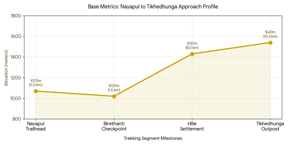
Hitting the Trailhead: Starting the Ascent from Nayapul or Birethanti
Actually, your trek formally transitions from vehicle to foot at the cusp of the roaring Modi Khola river valley. This entry stage will offer a pleasant introduction to the quintessential Nepalese rural countryside: warm air, oxygen-rich, fragrant with terraced farms and subtropical forest.
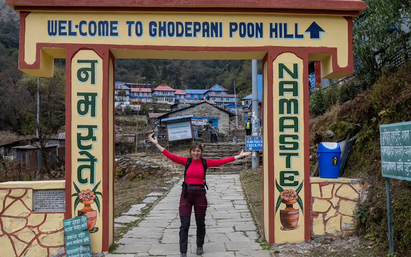
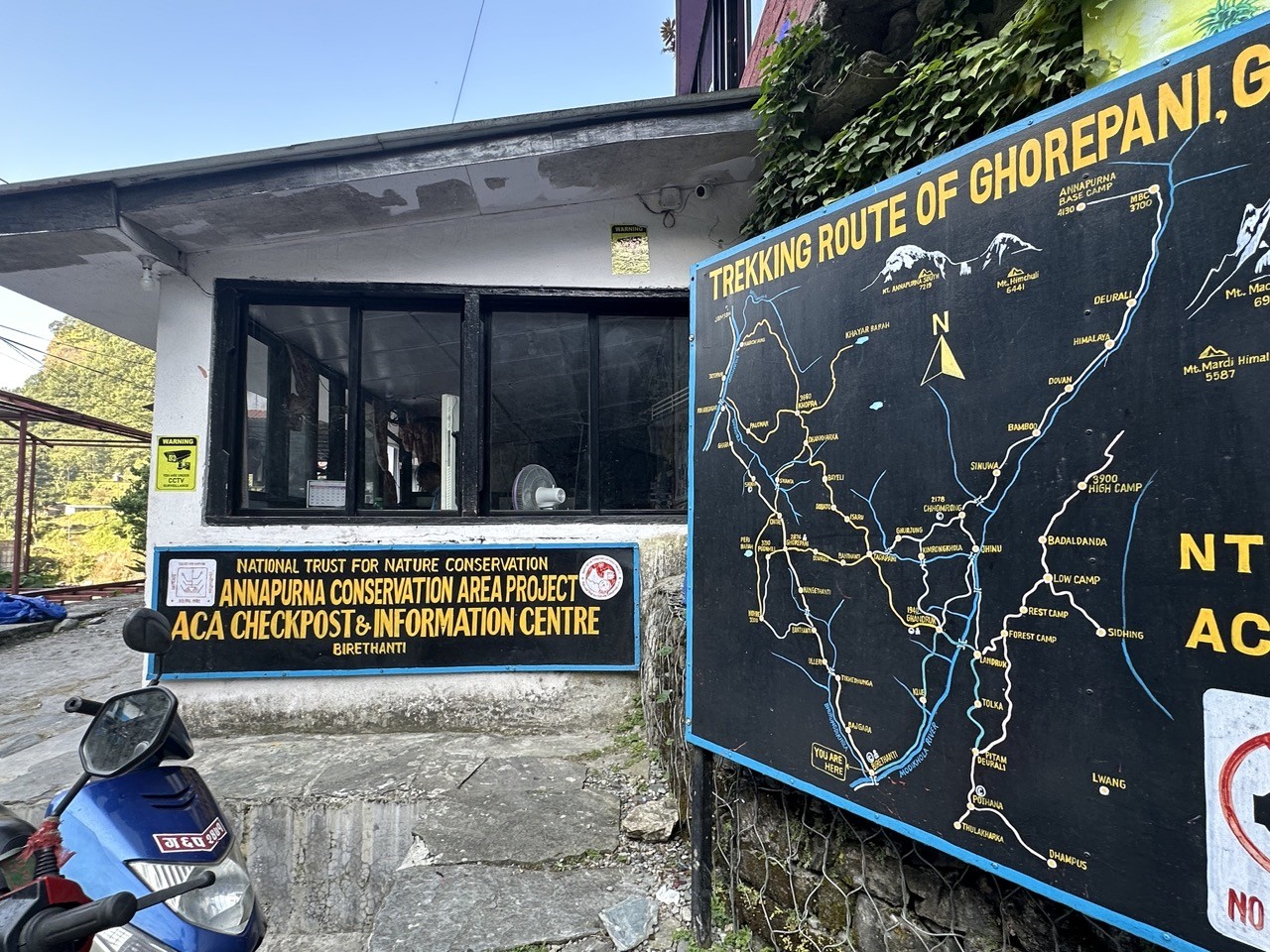
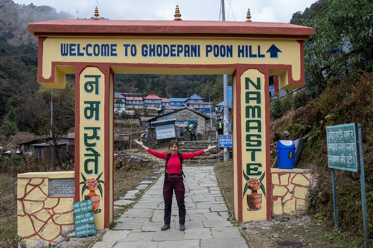
Birethanti – the official entry point for Annapurna trekking routes, where permits are checked before starting the Poon Hill adventure.
Trailhead Infrastructure & Geography :
The Official Starting Gate: Leaving your transport at the Nayapul starting elevation of 1,070 meters (3,510 ft), you’ll make your way down a dirt track to the river.
The Permit Gateway: Within 20 minutes, you’ll reach the riverside village of Birethanti where your permits (ACAP & TIMS) will be checked at the official Birethanti checkpoint.
The Riverside Track: You'll follow a mostly flat dirt track, tracing the path of the Bhurungdi Khola through small farming villages, pastures and mini waterfalls.
The Low-Altitude Advantage: Walking through this low-altitude foothill segment is a gentle warm-up to the lungs and legs before the steep ascent truly begins.
Max lung efficiency; low risk of shortness of breath
Ambient Temperature
Warm & humid; 22 C to 28 C (71-82 F)
High perspiration rate; light clothes recommended
Water Availability
Bottled water is readily available
High need for hydration due to heat and humidity.
Microclimate Transition: Low Foothills Air Profile
The Sun Protection Rule: The valley route from Nayapul to Tikhedhunga is very exposed to sun and gets quite hot. Be generous with your high-SPF sunscreen, wear a wide-brimmed hat, and bring an electrolyte powder or tablet to dissolve in your water bottle; this will help replenish the minerals lost during high perspiration along these warm, flat river flats.
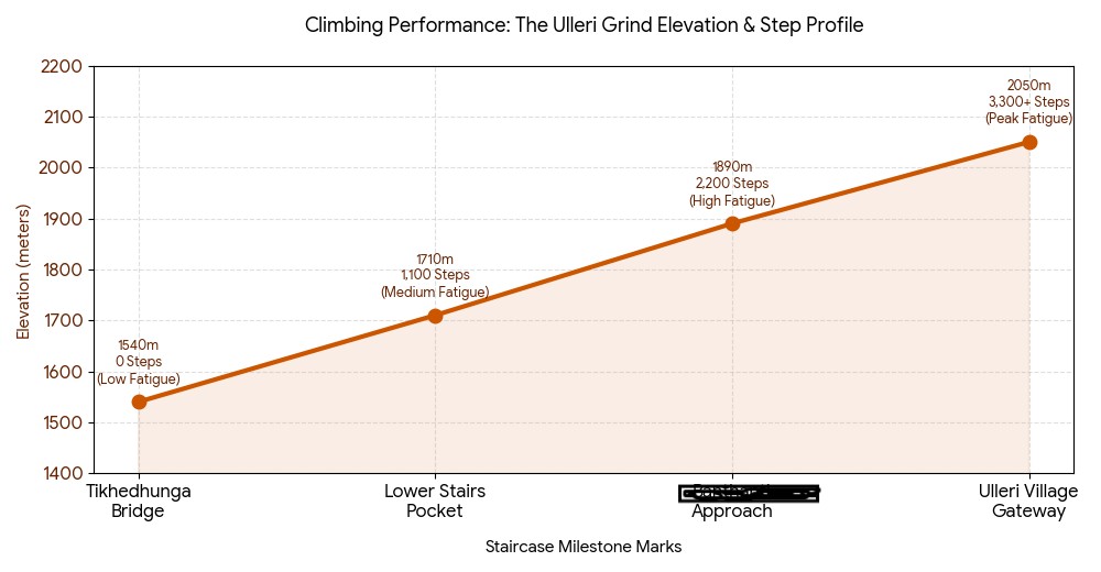
The Legendary Staircase: The Crucial Elevation Jump from Tikhedhunga to Ulleri
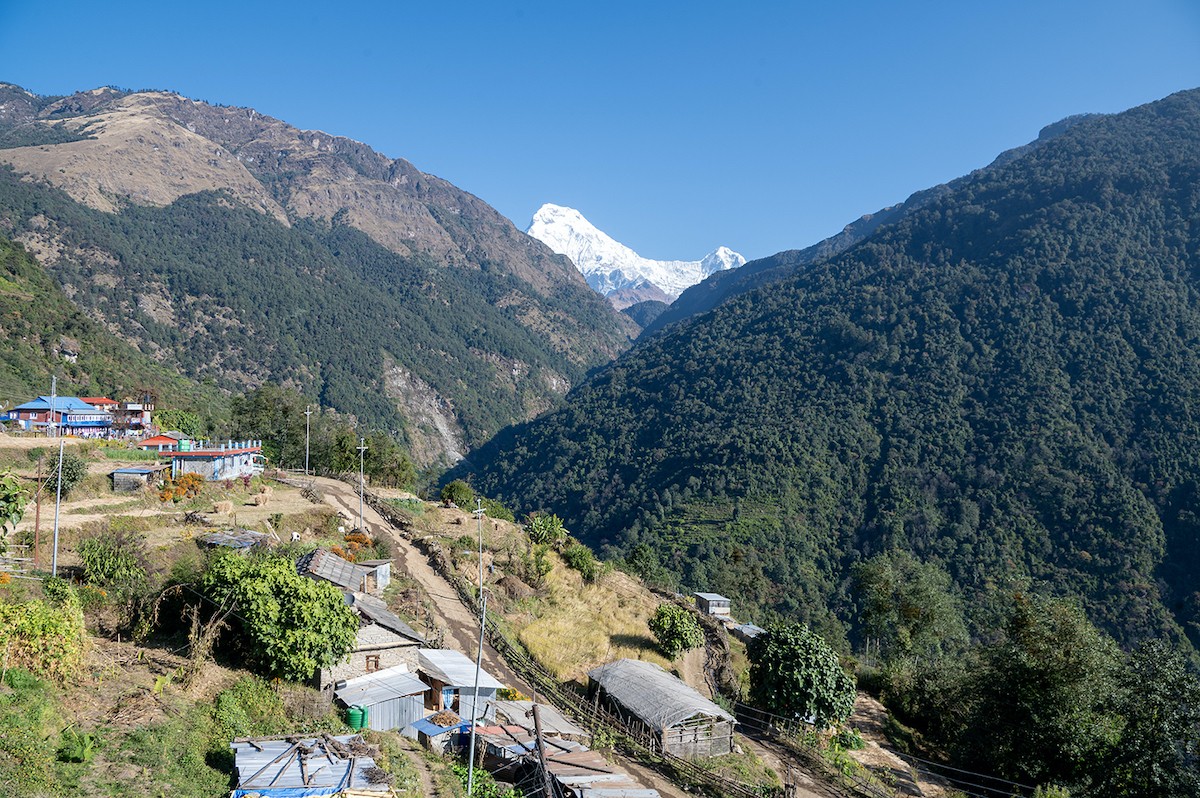
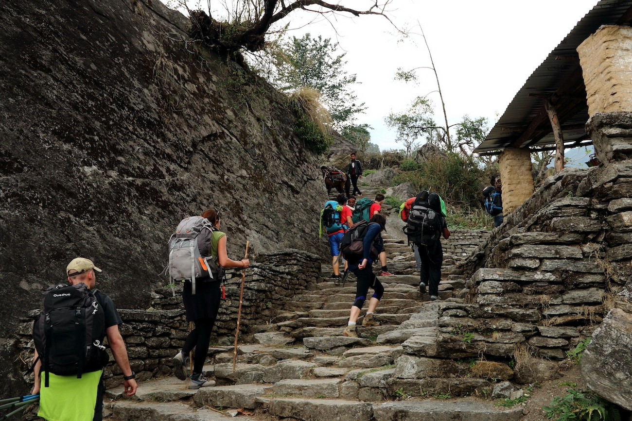
Actually, the gentle river walk quickly escalates into an intense effort as you leave the suspension bridge over the Bhurungdi Khola behind and face one of the most arduous parts of your journey – the massive, stone staircase climbing the side of the hill to Ulleri.
Ulleri Village – beautiful terraced fields and mountain scenery showcasing the charm of the Annapurna region.
[Ulleri Ridge Village Rim: 2,050 m]- (The 3,300+ Stone Steps Climb)- [Net Vertical Gain: +510 meters]
[Bhurungdi Khola Suspension Bridge]
[Tikhedhunga Base Outpost: 1,540 m]
Staircase Mechanics & Elevation Changes:
The Launching Pad: The ascent begins right above the Tikhedhunga altitude of 1,540 meters (5,052 ft), where the dirt trails abruptly turn to stone steps.
The Vertical Wall: The famous Ulleri stone steps climb is actually a stone stairway featuring over 3,300 individually placed stones, each carved from the hillside itself.
The Sharpest Elevation Gain: This section represents the steepest elevation gain of the trek; you'll quickly rise 510 vertical meters (1,674 ft) in a very short distance.
The High Ridge Reward: The endless stairs finally relent as you reach the Ulleri village altitude of 2,050 meters (6,726 ft), with the first glimpse of Annapurna South.
Staircase Milestone Mark
Current Elevation (Metric) | Current Elevation (Imperial)
Physical Load Analysis: Stair Climbing vs. Flat Trekking
The Short-Step Technique: Trying to take large steps or to ascend the stairs quickly will tire your legs in fifteen minutes. Keep your gaze focused a few steps ahead, keep your strides short so your heels touch the stone with each step, and use your glutes rather than your calves for each upward push. Rest for 30 seconds every 100 steps to give your heart rate time to stabilize.
Climbing through the Rhododendron Canopy: From Ulleri to Banthanti
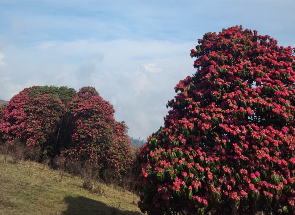
Leaving Ulleri and its demanding stone steps behind you enters a magical, shaded wonderland. The path transitions into a dense canopy of ancient oaks, moss-covered maples, and sprawling rhododendron trees. In the spring, the entire mountainside becomes a vibrant display of deep crimson, pink, and white blossoms.
Rhododendron flower – the national flower of Nepal, blooming beautifully along Ghorepani poon hill trekking trails in spring
[Banthanti Resting Stop: 2,250 m]- (Gentle Creek Crossings)
[Nanggethanti Midpoint: 2,460 m]
Actually, this segment provides a much-needed break for your lower joints. While you're still gaining altitude, the sharp, steep staircase gives way to a more forgiving and steady uphill pacing. The heavy forest cover keeps the intense midday sun at bay, lowering the temperature and creating a refreshing, crisp microclimate. This helps conserve energy for the steep final ascent to the ridge.
Landscape Dynamics and Forest Flora :
The Crimson Forest Umbrella: This is considered the largest rhododendron forest trek in the world and the natural shade provides an invaluable temperature reduction.
A Break in the Incline: The Banthanti trail altitude of 2,250 m (7,381 ft) is where the trail starts leveling out, introducing a mix of gentler dirt tracks with sporadic stone steps instead of a sustained, vertical climb.
Mountain Streams and Wildlife: The path follows mossy streams and crosses small wooden bridges where you'll often see vibrant Himalayan birds and wild langur monkeys in the canopy above.
Microclimate Comparison: Exposed Stairs vs. Shaded Forest Canopy
Ulleri stone steps – a challenging but rewarding climb through village life, forests, and stunning Annapurna landscapes.
Solar Radiation Exposure :
Ulleri Steps: High, with the intense direct sunlight heating up the stone face.
Forest Canopy: Low, with the dense trees filtering out UV rays and keeping the path cool.
Average Air Temperature:
Ulleri Steps: 22°C to 26°C (warm and humid)
Forest Canopy: 14°C to 18°C (crisp and mild)
Trail Surface Terrain:
Ulleri Steps: Hard, uniform, hand-cut stone steps.
Forest Canopy: Softer dirt paths with roots and stones.
Trekker Hydration Demand:
Ulleri Steps: High, with rapid fluid loss and a need for continuous electrolyte replenishment.
Forest Canopy: Moderate, as lower sweat rates make staying hydrated easier.
The Layering Rule: The temperature instantly drops once you enter the dense shade of the rhododendron forest. Don't wait until you're cold to make a change. Shed your sweaty trekking shirt and put on a lightweight, breathable fleece or windbreaker to keep your core warm while hiking through these cooler mountain sections.
Entering the Base Station: Arriving at Ghorepani Village Elevation
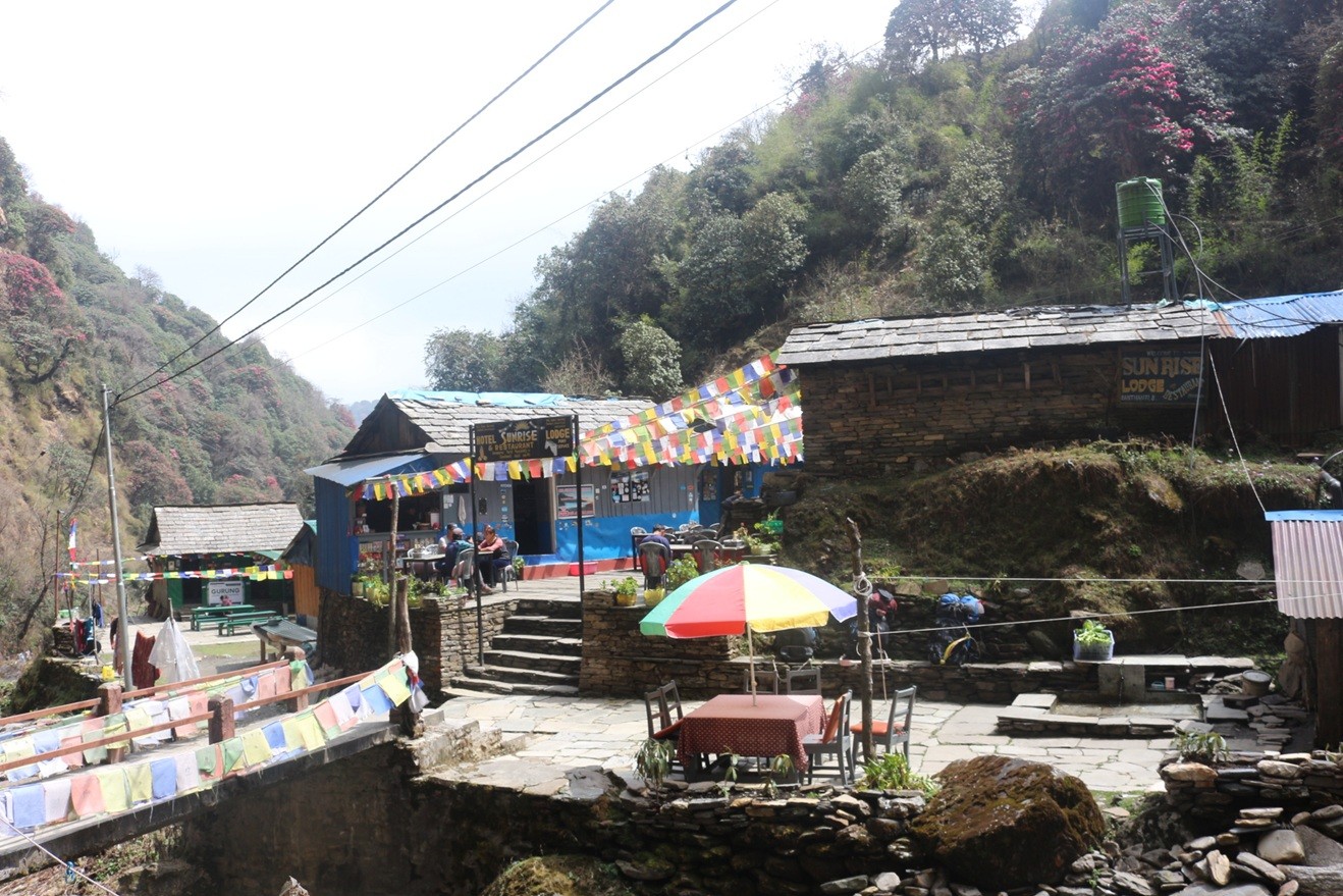
Leaving the deep forest paths, you'll pass through a tiny outpost called Nangethanti before encountering another steep set of stone switchbacks. The trail gradually climbs until you pass under a grand stone archway and enter Ghorepani village, with its distinctive blue-roofed teahouses. The village is nestled in a high mountain saddle and provides stunning views of the Kali Gandaki Gorge-the deepest gorge in the world-and the imposing peaks of the Dhaulagiri and Annapurna ranges.
Ghorepani Gate – a joyful stop for trekkers heading toward Poon Hill and the Annapurna sunrise.
[Poon Hill Sunrise Apex: 3,210 m]-(Pre-dawn steep push)
[Ghorepani Base Station Rim: 2,874 m] Highest Overnight Milestone (~74% Oxygen)-(Steady forest climb)
[Nanggethanti Forest Spot: 2,460 m]
In fact, this village is strategically located at a significant Ghorepani elevation meters feet milestone of 2,874 m (9,429 ft), marking your highest overnight stay. Resting just below the critical 3,000 m line allows your body to gently adjust to the reduced oxygen density without the serious risks of high-altitude mountain sickness, ensuring you'll wake up refreshed for the early morning ascent to the summit.
Strategic Features of the Staging Hub :
The Upper Altitude Milestone: Being at 2,874 m means you are now in thin air with approximately 74% of the oxygen available at sea level. This mild oxygen deprivation stimulates your body to produce more red blood cells.
Thermal Management Shock: The village is built on an exposed ridge saddle and the temperatures drop below freezing at night, making the central wood stoves in the teahouses the primary social gathering spots.
The Ultimate Sunrise Launchpad: The village is positioned directly below the Poon Hill ridge line, so you can sleep relatively comfortably before the short pre-dawn hike to the viewpoint.
Daily Elevation Step Grid: Banthanti to Ghorepani Base :
Banthanti Forest Stop
Altitude: 2,250 m (7,382 ft)
Net Vertical Gain: 0 m
Oxygen Density: ~79%
Terrain Snapshot: Soft dirt tracks under heavy forest cover.
Nanggethanti Midpoint
Altitude: 2,460 m (8,071 ft)
Net Vertical Gain: +210 m
Oxygen Density:* ~77%
Terrain Snapshot: Stone steps alongside cascading mountain streams.
Ghorepani Village Rim
Altitude: 2,874 m (9,429 ft)
Net Vertical Gain: +414 m
Oxygen Density: ~74%
Terrain Snapshot: Exposed ridge trails leading to modern stone teahouses.
The Overnight Thermal Rule: Don't let the comfortable daytime temperatures trick you. As soon as the sun dips behind the Dhaulagiri range, Ghorepani's temperature plummets. Unpack your heavy down jacket and put on your thermal base layers as soon as you check into your teahouse room to keep your core temperature high before the night chill sets in.
[Trip:poon-hill-jhino-danda-hot-spring-trek]
Why You Skip a Formal Acclimatization Day on the Poon Hill Route
While longer Himalayan trekking routes, such as the Everest Base Camp and Annapurna Circuit trails, require dedicated 'rest days' in the itinerary to adjust your body to thin air, you’ll see there are no such days included for this particular Poon Hill trek. This isn’t a case of rushing; it’s a structure based on human physiology at high altitude, and the trail's design.
[High Alpine Risk Zone Boundary: 3,500 m] -Serious Risk Threshold
[Poon Hill Viewpoint Apex: 3,210 m] (Brief 1-Hour Visit)
[Ghorepani Overnight Base: 2,874 m] Fully Acclimatized While Moving
[Ulleri Ridge Settlement: 2,050 m]
Because your highest overnight resting points during Poon Hill Trek remain safely below the points where major atmospheric pressure losses occur, your body continuously remains a step ahead of the air thinning, allowing a smooth, safe journey without needing to simply sit still for a day to acclimatize.
Physiological Safety & Trail Mechanics :
The Low Sickness Risk: The actual risk of 'Poon Hill altitude sickness' is incredibly minimal as you will never cross over into the altitude threshold that often triggers acute mountain sickness (AMS).
The Smart Sleeping Margin: You will spend your highest night sleeping at an altitude of 2,874m, comfortably resting below the globally recognized "high-risk" mountain zone boundary of 3,500m ($11,482\text{ ft}$).
Adaptation on the Move: This trail structure employs a strategy of 'gradual ascent safety,' whereby the constant daily increases allow your body to acclimatize dynamically without requiring 24 hours of immobility.
The Foundation of Conditioning: Your main focus will be on 'conditioning and pacing,' rather than worrying about thin air, because on this trail, the physical effort on the countless stairs will tax your body more than oxygen deficiency.
Acclimatization Element
Ghorepani Poon Hill Loop
High Alpine Treks (e.g., Thorong La)
Dedicated Rest Days
0 Days Required
1 to 3 Days built into the itinerary
Overnight Sleeping Range
1,540m to 2,874m
3,500m to 4,900m
Primary Physiological Threat
Minor muscle fatigue and mild shortness of breath
Severe AMS, HAPE and HACE risks
Oxygen Concentration Level
74% to 89% of sea-level density
Drops below 55% to 65% at pass summits
Acclimatization Strategy: Foothills vs. High Alpine Passes
Daily Elevation Climbing Thresholds :
Day 1: Nayapul Base to Ulleri Ridge
Elevation Gain: +980m (+3,215 ft)
Acclimatization Status: Low altitude; maximum muscle oxygenation.
Day 2: Ulleri Ridge to Ghorepani Rim
Elevation Gain: +824m (+2,703 ft)
Acclimatization Status: Approaching thin-air zone; minor lung adjustment begins.
Acclimatization Status: Short peak exposure followed by an immediate drop to lower, thicker air.
The Acclimatization Ascent Rule: While very mild symptoms like a headache or dehydration can occur if you overdo it on this route, the risk of severe altitude sickness is virtually nonexistent during Poon Hill Trek. To ensure the continued smooth adaptation of your body, use the "talk test" during your ascents: if you find it difficult to hold a simple conversation with your guide without gasping for air, your heart rate is too high, so ease up on your pace and focus on maintaining an aerobic energy level.
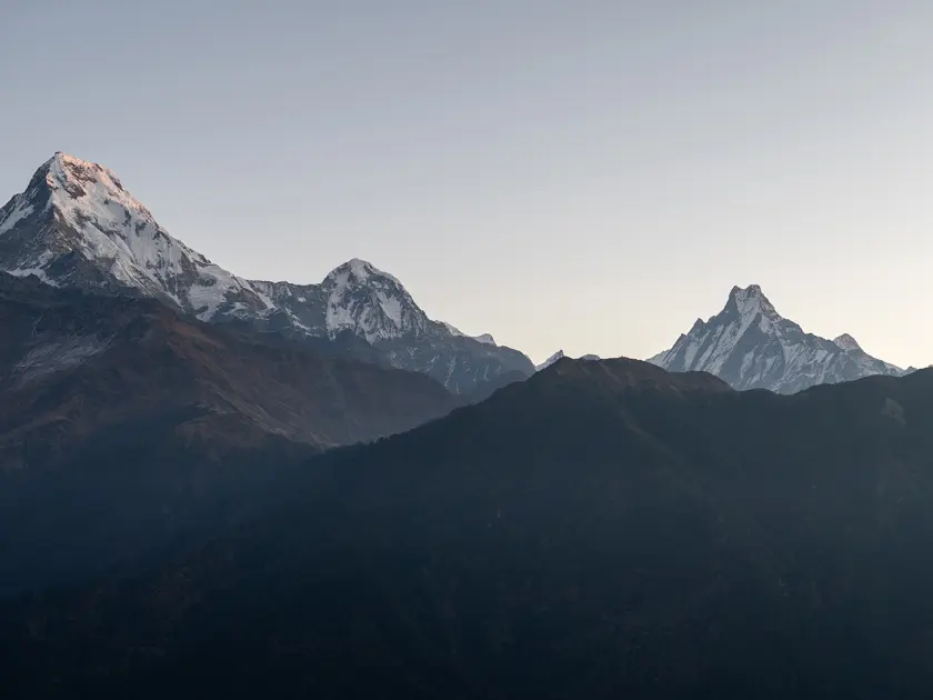
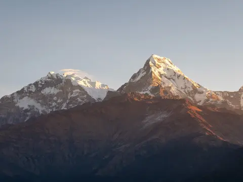
Standing at the Summit: The Pre-Dawn Push to Poon Hill Viewpoint
Your journey’s grand finale will be preceded by an early morning start under a starry sky that would be the envy of any astronomer. You’ll leave your Ghorepani lodge before sunrise in the crisp, freezing air and ascend on the winding, stone path illuminated by the dim light of headlamps, weaving through rhododendron trees coated in a layer of frost.
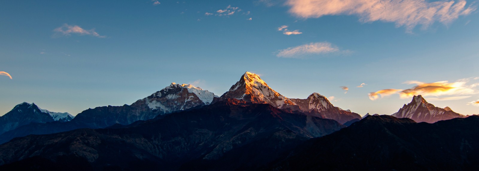
Actually, this steep but short ascent up a ridge is the crowning achievement of your trek. Upon reaching the summit viewpoint at 3,210 meters, the biting cold will be instantly forgotten as the sun crests the horizon, bathing the towering, snow-capped peaks in hues of pink, orange, and gold.
Summit Geography & Mountain Panoramas :
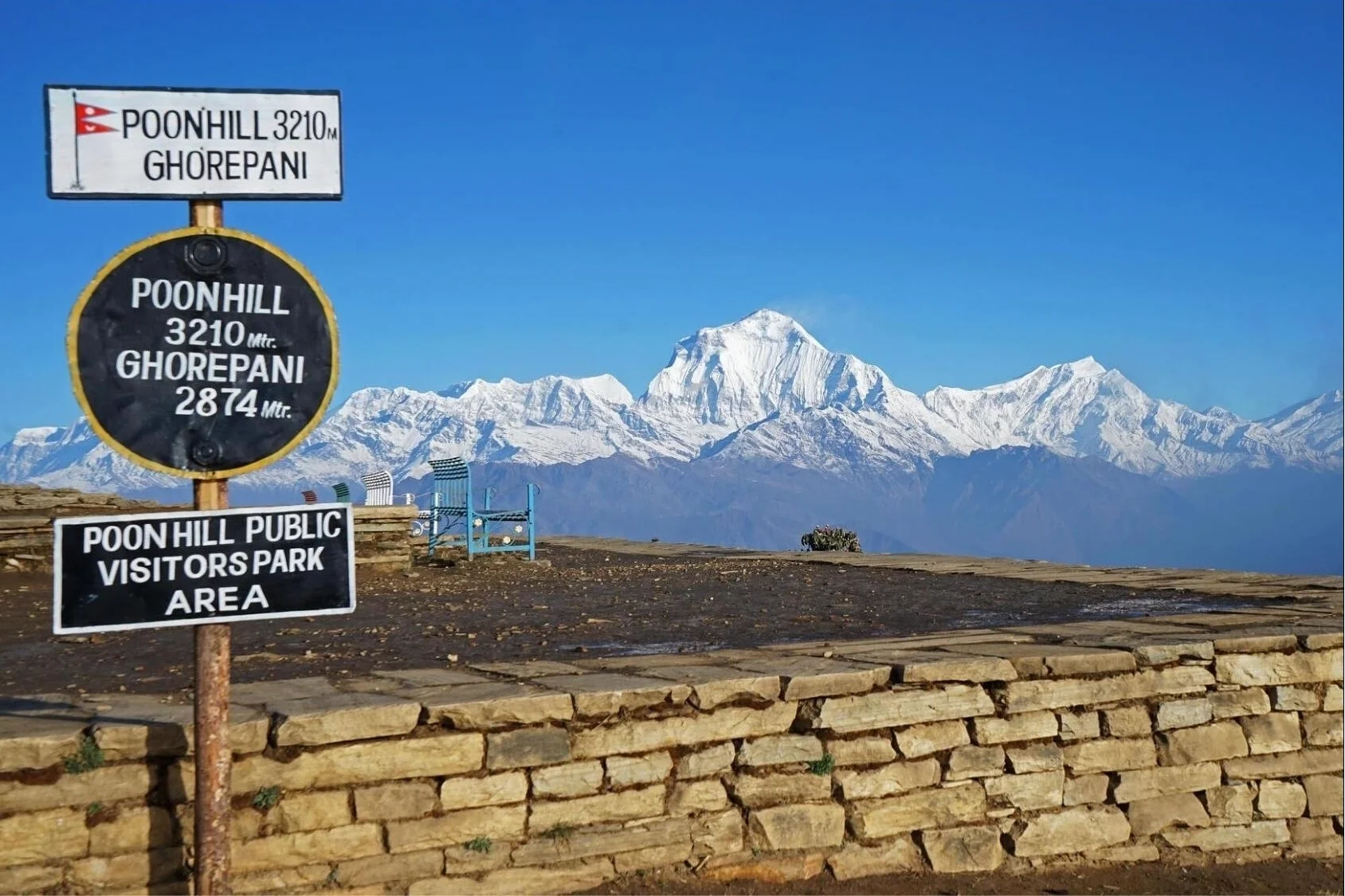
The Absolute Trail Apex: The Poon Hill actual height is precisely 3,210 meters (10,531 ft), marking the highest point of your entire trek.
The Dhaulagiri Giant View: The western horizon will be dominated by Dhaulagiri, the seventh-highest mountain in the world, rising majestically to 8,167 meters (26,795 ft).
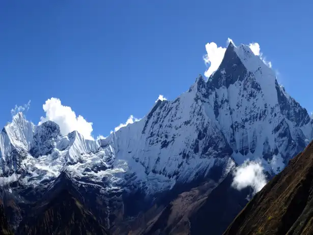
The Annapurna Wall: In the north, the formidable Annapurna I will stand at 8,091 meters (26,545 ft), accompanied by the iconic, sacred pyramid shape of Machapuchare (6,993 m).
The Descent Escape Route: After soaking in the breathtaking vista, you will begin a swift, approximately 45-minute descent back down to Ghorepani for a much-needed warm breakfast and the chance to rewarm your lungs with the thicker, more familiar air.
Mountain Peak Name
Actual Peak Elevation (M) | Actual Peak Elevation (FT)
Cardinal Direction from Hill | Visual Character
Mt. Dhaulagiri I
8,167 m | 26,795 ft
Northwest | A massive, imposing isolated block of ice.
Mt. Annapurna I
8,091 m | 26,545 ft
North-Northwest | The vast, high wall of the Annapurna sanctuary.
Annapurna South
7,219 m | 23,684 ft
North | Appears closest, towering with a broad, rocky face.
Machapuchare
6,993 m | 22,943 ft
Northeast | The distinctive, unclimbed 'Fishtail' peak with its twin points.
Viewpoint Geography: The 8,000-Meter Giants and Neighboring Peaks
Morning Climb Breakdown: Ghorepani to the Peak
Poon Hill sunrise – one of the most iconic Himalayan views, where golden light paints the Annapurna ranges.
The Staging Lodge Departure
Trail Landmark: Ghorepani Ridge Lodges
Current Elevation: 2,874 m (9,429 ft)
Distance Covered: Start Point
Average Temperature: -2°C to 4°C (28°F to 39°F)
The Mid-Way Ridge Path:
Trail Landmark: Stone Stairs & Gateway Ticket Booth
Current Elevation: 3,040 m (9,973 ft)
Distance Covered: 0.8 km
Average Temperature: Heavy frost on stone paths; steep vertical grade.
The Panoramic Summit Platform
Trail Landmark: Poon Hill Viewpoint Tower
Current Elevation: 3,210 m (10,531 ft)
Distance Covered: 1.5 km
Average Temperature: Blustery ridge winds; alpine sunrise exposure.
The Pre-Dawn Freezing Rule: The temperature at the Poon Hill summit tower can feel considerably colder than down in the village due to the combined effect of high altitude and strong morning winds. Avoid hiking up in your down jacket to prevent sweating through your base layers on the climb, which can lead to freezing when you finally reach the exposed summit. It’s better to hike in a lighter fleece and windbreaker and then pull on your warm down jacket as soon as you reach the viewpoint to trap heat while waiting for the sunrise.
Crossing the Ridge Line: Navigating the High Pass toward Tadapani
Returning to Ghorepani for a quick, warm breakfast, you pull on your boots to face yet another brand of geological challenge. Instead of a quick drop down to the low river valleys, the trail now traverses along a high mountain spine to the east of Ghorepani, on a scale that mirrors that of the Poon Hill ridge line.
[Deurali Pass Scenic Spine: 3,090m] Highest point of the forest trail (Relentless Mountain Gorges)
[Kunchhi Waterfalls and Riverbed: 2,410m] (Short Final Climb)
[Tadapani Forest outpost: 2,630m]
In fact, this is perhaps the most varied day of hiking on the whole circuit; the trail does climb briefly back up into thin alpine air, before diving into a deep, moss-covered gorge. Mountain streams have carved steep, dramatic drops through the grey gneiss rock as the path wends its way through ancient trees.
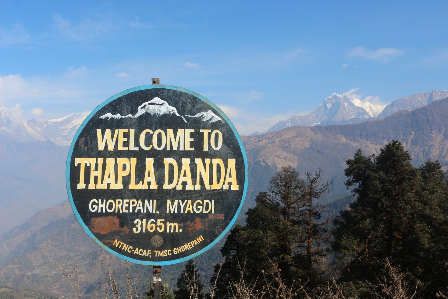
Thapla Danda/Deurali Pass- between Ghorepani - Tadapani
Ridge dynamics and forest trails:
High jungle pass: You climb steeply to an elevation of 3,090 meters (10,137 ft) at Deurali Pass, where you'll get a last, eye-level view of Dhaulagiri and the Annapurna Range before disappearing into the trees.
Knee-pounding downhill descent: The trail plunges down steep stone steps and roots for over 600 vertical meters before reaching a shady river canyon.
Forest outpost: A short, last climb up from the river gorge leads to the isolated Tadapani forest trail at 2,630 meters (8,628ft), a village nestled amongst rhododendrons directly below the stark rock face of Fishtail Mountain.
Terrain phase shift: Deurali Pass and Tadapani Forest
Max. Inclination angles:
Deurali Pass: Moderate; 15 to 22, consistent climbing along an open ridge.
Tadapani Descent: Extreme; 25 to 35 degree drops down rough stone stairs.
Dominant surface features:
Deurali Pass: Exposed dirt trails, weather beaten stones and open mountain ridges.
Tadapani Descent: Slick stone steps, damp mossy ground and loose, exposed tree roots.
Key structural hazards:
Deurali Pass: Blustery winds along narrow ridgelines and drops.
Tadapani Descent: High joint impact, deep gorges and slick descending trails.
Muscle/joint strain:
Deurali Pass: High calf strain and intense lung demand from a consistent uphill.
Tadapani Descent: Intense quadricep strain and heavy impacts upon knees and ankles.
Elevation Profile segment: Ghorepani to Tadapani Forest outpost
Ghorepani Ridge base:
Altitude: 2,874 meters (9,429 feet)
Net change: - (Baseline)
Atmosphere: Crisp alpine air, open village atmosphere.
Deurali Pass Summit:
Altitude: 3,090 meters (10,137 feet)
Net change: +216 meters (+708 feet)
Atmosphere: High ridgeline, stark mountain vistas.
Banthanti (East) Gorge:
A Teahouse stop between Banthanti to Ghorepani
Altitude: 2,520 meters (8,267 feet)
Net change: -570 meters (-1,870 feet)
Atmosphere: Damp, mossy forest canyon and treacherous stone steps.
Tadapani Forest Hub:
Altitude: 2,630 meters (8,628 feet)
Net change: +110 meters (+361 feet)
Atmosphere: Forest clearing, impressive mountain views of Machapuchare.
Trekking Pole Rule: The steep descent from Deurali Pass down into the shaded gorge places tremendous braking load upon the knees, a heavy demand that can quickly cause injury. Shorten trekking poles by five to ten centimeters (or two to four inches); this will bring the pole’s planted point lower, just ahead of your boot on the step, and utilize arm and shoulder musculature to absorb up to 20% of body weight load, reducing the forces upon your joints.
Cultural Descent: Entering the Traditional Gurung Hub of Ghandruk
Actually, the descent from the densely rhododendron-forested outposts of Tadapani begins a slow and pleasing decline toward the lower valleys. As the altitude drops, the rough forest trail develops into wide, immaculately maintained flagstone paths that zig and zag through terraced plots of millet, barley, and mustard greens.
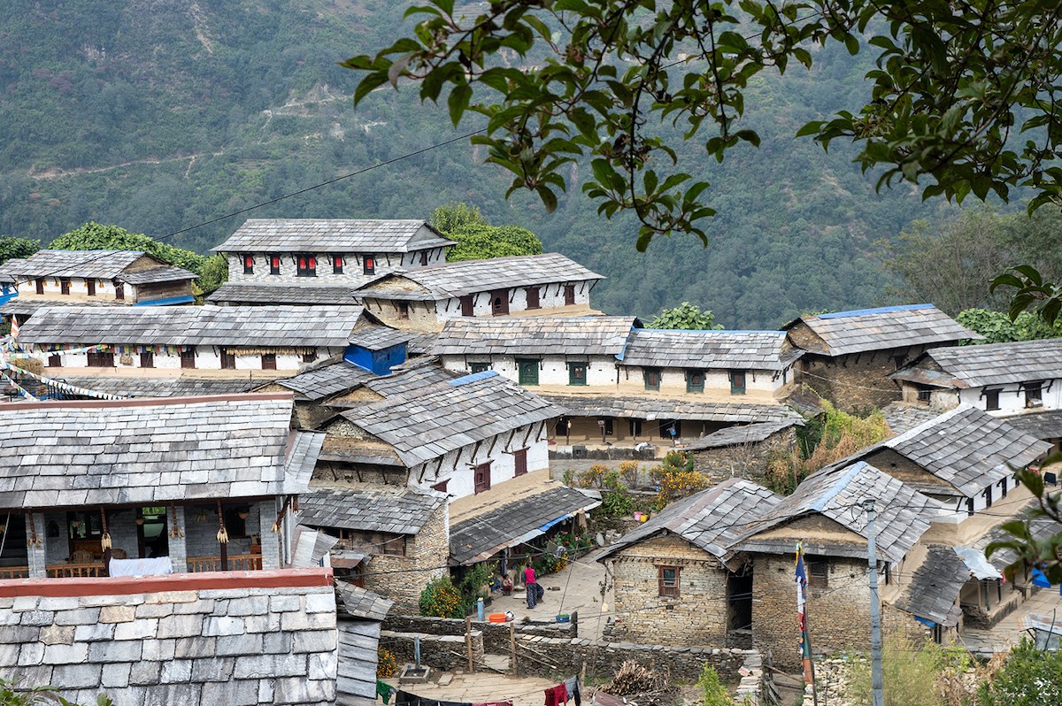
Ghandruk Village – a beautiful traditional Gurung settlement surrounded by Himalayan peaks and rich mountain culture.
[Tadapani Forest Clearing: 2,630m] (Gradual, Sunny Valley Drop)
[Ghandruk Ethnic Gurung Village: 1,940m] Warm, Rich Cultural Center (Final stone stair steps)
[Syauli Bazar river base: 1,220m]
In fact, this segment offers a delightful blend of physical release and cultural insight. As you reach the large settlement of Ghandruk, the tight forest trails widen to expose neat, slate-roofed stone houses, well tended flower gardens and smiling locals; this is arguably the most pleasant overnight stop in the entire circuit.
Village architecture and alpine backdrop:
Lower altitude relief: The village of Ghandruk sits at 1,940 meters (6,365ft), and the thicker, warmer air brings immediate relief to your lungs and legs after days at higher altitudes.
Historical mountain settlement: Ghandruk is considered the heart of the ethnic Gurung culture in Nepal; a community renowned for their unique customs and renowned military service in the Gurkha regiments.
The giants at the door: From your tea house balcony in Ghandruk, the mountain vistas look impossibly close; Annapurna South (7,219m) and Hiunchuli (6,441m) loom large and imposing.
Micro-climate comparison: High forest outpost versus lower Gurung valley
Atmospheric oxygen density:
Tadapani Ridge: 76% of sea level (Noticeably thin during brief steep sections).
Ghandruk Village: 81% of sea level (Thick, nourishing air for muscle recovery).
Average daily temperature:
Tadapani Ridge: 8C to 14C (Chilly, shaded and damp).
Ghandruk Village: 18C to 24C (Warm and pleasant, exposed to sunshine on terraces).
Trail environment:
Tadapani Ridge: Dark, dense canopy of oak and rhododendron trees, overgrown with moss.
Ghandruk Village: Brightly lit terraced farms, neatly paved plazas and slated homes.
Trekker's load:
Tadapani Ridge: Continuous braking load upon knees down treacherous stairs.
Ghandruk Village: Easy, leisurely amble along well-maintained, flat stone paths.
The Cultural Exploration Rule: Do not race to your lodge when you arrive in Ghandruk; use the pleasant afternoon temperature and denser air to take an extended ramble through the ancient, paved alleys of the village. Visit the local Old Gurung Cultural Museum to see how traditional farmers worked and lived in days gone by; consider making a small donation to help with the preservation of the local heritage.
Safety in Annapurna Foothills: Identifying Mild Altitude Sickness Symptoms
While the Annapurna lower loops offer incredible safety compared to high-altitude giants like the Everest Base Camp trek, it's imperative to remember that safety in the mountains must never be taken lightly. True Acute Mountain Sickness (AMS) is unlikely below 3,000m, but the immense physical toll of thousands of stone steps coupled with crisp, freezing pre-dawn air can fool the body easily. Know how to tackle these small changes to ensure a safe, rewarding hike from trailhead to summit.
[3,210 m: Poon Hill Peak] Brief exposure (slight breathlessness is normal) (Descend to thicker air)
[2,874 m: Ghorepani Rim] Sleep safe at this baseline (body recovery) (Thick Oxygen Zone)
[1,940 m: Ghandruk Hub] Full physical & respiratory relaxation
Alpine Health Safety Checklist :
Early warning signs to monitor: A mild dull headache or a tiny bit of dizziness on your pre-dawn ascent to Poon Hill does not mean panic; it likely means you need to take a rest break or slow your pace. These symptoms are more indicative of mild altitude sickness than anything dangerous at this elevation.
Hydration on the trails is King: Dry mountain air strips the humidity from your lungs faster than you realize due to the constant heavy breathing. Drink 3-4 liters of properly treated water daily to keep blood volume up and speed oxygen to your aching legs.
Control your breathing rate: Pace your breathing with your footsteps; keep both slow, controlled and aligned with each other. If you're gasping for air and can only say one sentence at a time, slow your pace dramatically.
Benefits of trekking pole utility: Trekking poles on dual steep ascents take enormous pressure off your back and legs, and, importantly, reduce the impact to your knees by 25% during lengthy descents.
Mild Altitude Sickness vs Standard Trekking Fatigue
Headache Baseline :
Mild AMS: A dull,throbbing headache commonly felt across the forehead or behind the eyes.
Trekking Fatigue: Neck strain from your heavy day pack causes the tension headache.
Respiratory Response:
Mild AMS: Breathing short and feeling breathlessness at rest while in the lodge.
Trekking Fatigue: Heavy, gasping breathing while ascending, which reverts back to normal with just a few minutes of rest.
Sleep Quality :
Mild AMS: Difficulty staying asleep, waking multiple times a night, having vivid, unusual dreams.
Trekking Fatigue: Falling into a deep, heavy sleep from a strenuous day.
Nausea & Appetite :
Mild AMS: A slight upset stomach, a loss of appetite.
Trekking Fatigue: Looking forward to the usual enormous plate of delicious dal bhat, feeling ravenously hungry.
The Golden AMS rule for prevention: If your mild headache and slightest touch of nausea don't improve after drinking a liter of water, taking a pain killer and taking a one-hour break to relax at your lodge, then do not ascend to the higher village. Sleep at your current altitude and observe your symptoms in the morning. If your symptoms do not diminish, then your best, most efficient, and truly only correct approach is a gradual, controlled descent.
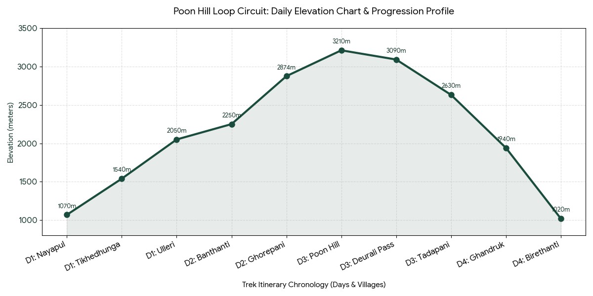
Conclusion: A master summary table of Poon Hill altitude variations
Actually, this final master table should be seen as your absolute quick reference guide and pocket itinerary. It maps out the entire geographical structure of the classic 4-day Poon Hill loop; noting each village's precise elevation, gain or loss of altitude, and trail characteristics to assist in your daily trekking planning.
+624m | Steady stone switchbacks, open ridge trails | Moderate / Thin air
Day 3: Poon Hill Peak Apex
3,210m | 10,531ft
+336m | Steep pre-dawn stone stairs with frost | Strenuous / Cold
Day 3: Deurali Pass Ridge
3,090m | 10,137ft
-120m | Open mountain ridge, panoramic views | Moderate
Day 3: Tadapani Clearing
2,630m | 8,628ft
-460m | Slippery forest tree roots and stone steps | Moderate / High impact
Day 4: Ghandruk Gurung Hub
1,940m | 6,365ft
-690m | Wide stone village paths, stairs | Easy / Relaxed
Day 4: Kimche / Birethanti
1,020m | 3,346ft
-920m | Neat stone stairs to river bed | Easy / Descending
Poon Hill Daily Elevation Chart :
The Advantage of "Sleep Low, Hike High": This route's structure offers immense safety advantages for children, the elderly, and first-time trekkers. Because you will spend your highest night at Ghorepani (2,874m / 9,429ft) and will only be at the Poon Hill Summit (3,210m / 10,531ft) for one to two hours of viewing the sun rise, your body is spared significant prolonged high altitude stress and the risk of severe altitude sickness is minimized while you receive the benefit of world class panoramic high Himalayan views.
Ghorepani Poon Hill Trek Altitude- FAQS
1. What's the initial elevation on the Poon Hill trek? The classic Poon Hill trek altitude profile usually starts in Nayapul at an altitude of 1,070 meters (3,510 feet). Some newer trek routes even involve taking a 4x4 drive up to Tikhedhunga at 1,540 meters to avoid the unexciting first day of road walking at a low elevation.
2. What's the highest point reached during the Poon Hill trek? The most sought-after and highest point of the Poon Hill trek is the legendary Poon Hill viewpoint, which climbs to 3,210 meters (10,531 feet) above sea level. This ridge summit is usually visited in the early morning for the breathtaking sunrise over the imposing Dhaulagiri and Annapurna mountain ranges.
3. What's the total walking distance of the Poon Hill trek altitude profile? The entire Poon Hill trek distance, measured from one end to the other, is typically about 32 to 50 kilometers (20 to 31 miles). This varies depending on the specific route you follow and if you choose to include Ghandruk village in your itinerary.
4. Is the Poon Hill trek elevation profile suitable for beginners? Absolutely, the smooth Poon Hill trek elevation profile is ideal for novice trekkers. It's known as the least demanding trek for beginners due to its gentle vertical climbs, posing much less risk of severe altitude sickness compared to higher Annapurna treks.
5. Why are the Ulleri stone stairs infamous for the Poon Hill trek altitude profile? The stone stairs between Tikhedhunga and Ulleri are the most challenging section of the Poon Hill trek difficulty. You have to ascend over 3,000 stairs, climbing more than 500 vertical meters in just one afternoon; take your time on this steep climb.
6. What is the elevation of Ghorepani village and what is its role in the trek? Ghorepani is perched at an altitude of 2,874 meters (9,429 feet). It’s a popular teahouse settlement that acts as a central staging post for the trek, sitting just below the ridge leading up to the Poon Hill viewpoint before the pre-dawn sunrise climb.
7. How much does the elevation change daily on the hike to Ghorepani? The climb to Ghorepani from Ulleri (2,020 meters) only involves a 854 vertical meter ascent. This gradual climb passes through beautiful, cool, and dense rhododendron forests, which contributes to the Poon Hill trek difficulty remaining highly manageable for families and even children.
8. Does the Poon Hill trek elevation profile present significant risks for altitude sickness? The risk of developing Acute Mountain Sickness (AMS) on this trek is very low. Overnight stays are kept below the critical 3,000-meter threshold, meaning severe altitude issues are extremely rare and making it a perfect introductory trek.
9. What's the vertical distance between Ghorepani and the Poon Hill summit? The trek from Ghorepani village to the top of Poon Hill is a short but steep 336-meter vertical gain. It takes around 45 to 60 minutes to hike up the stone-paved path in the dark, ascending from 2,874 meters to the viewing platform at 3,210 meters.
10. How does the amount of available oxygen vary throughout the Poon Hill trek altitude profile? At the start of the trek, you have 100% effective oxygen available, but at the highest point on the Poon Hill trek, 3,210 meters, this drops to roughly 70%. This might cause some breathlessness but rarely leads to severe symptoms.
11. What’s the most effective way to tackle the Poon Hill trek difficulty? Investing in a good pair of trekking poles is one of the best ways to manage the Poon Hill trek difficulty, especially for protecting your knees on the demanding Ulleri stairs. Maintaining a steady, unhurried pace and staying hydrated will make the climb much smoother.
12. How much does the Poon Hill trek cost, considering its altitude? An average Poon Hill trek cost ranges from $250 to $500 USD per person. As it's a relatively low-altitude trek reachable by car from Pokhara (unlike more remote treks requiring expensive flights), it remains Nepal's most budget-friendly lodge trek.
13. What kinds of landscapes will I encounter on the Poon Hill trek elevation profile? The scenery transforms dramatically as you ascend. You’ll start with subtropical river valleys and terraced farmland, move into lush, mossy rhododendron and oak forests, and finally emerge onto alpine ridges with magnificent views of snow-capped peaks.
14. Are there any treacherous high-altitude mountain passes on the standard Poon Hill trek itinerary? No, a standard Poon Hill trek itinerary bypasses any dangerous high mountain passes. It's a straightforward low-altitude foothills circuit, avoiding the risks of glaciers and thin air found on longer treks like the Annapurna Circuit.
15. What are the most prominent peaks visible from the summit of the Poon Hill trek altitude profile? From the 3,210-meter Poon Hill summit, you can enjoy views of many towering peaks, including the gigantic Dhaulagiri I (8,167 meters), Annapurna South (7,219 meters), Machhapuchhre (Fishtail, 6,993 meters), and Nilgiri.
16. Is travel insurance required for the low Poon Hill trek elevation? Even though the Poon Hill trek elevation is not extremely high, it's always wise to have comprehensive travel insurance that covers basic medical needs and emergency evacuation, just in case of unexpected accidents on the remote trail.
17. How does the altitude profile impact night-time temperatures on the trek? Night-time temperatures can get quite cold as you gain elevation. While Pokhara and Nayapul are warm, the teahouses in Ghorepani (2,874 meters) can dip to near freezing (0°C to 5°C / 32°F to 41°F) during the main autumn and spring trekking seasons.
18. Is it possible to shorten the Poon Hill trek distance? Yes, if you are fit enough, you can do a shorter 3-day Poon Hill trek itinerary. You can take a jeep to Ulleri or Hile, trek to Ghorepani on day one, visit Poon Hill on day two, and descend to Ghandruk to catch your jeep back.
19. What is the altitude profile of the scenic Gurung village of Ghandruk? Ghandruk village is located at a pleasant altitude of 1,940 meters (6,364 feet). It's usually the last overnight stop on the traditional loop trek and offers beautiful, up-close views of Annapurna South. The hike down to the riverbed from here involves a long descent on stone stairs.
20. What is the general success rate for those attempting the Poon Hill trek difficulty? The Poon Hill trek has a remarkable success rate of around 99%. Due to the gradual vertical variations, comfortable teahouse facilities, and generally lower risk of altitude-related problems, it's a trek that almost everyone can complete.