[{"name":"Everest Base Camp Helicopter Tour","duration":"1","image_url":"https:\/\/www.havenholidaysnepal.com\/storage\/trip-galleries\/1\/thumb_6cd53005d75a86e373d31419d1b14d78.webp","offer_price":1195,"url":"https:\/\/www.havenholidaysnepal.com\/trips\/everest-base-camp-helicopter-tour"},{"name":"Everest Mountain Flight","duration":"1","image_url":"https:\/\/www.havenholidaysnepal.com\/storage\/trip-galleries\/4\/thumb_3b0b4f1d6f72b0ad224daf4752f2c6e0.jpg","offer_price":285,"url":"https:\/\/www.havenholidaysnepal.com\/trips\/everest-mountain-flight"},{"name":"Everest Short Trek","duration":"9","image_url":"https:\/\/www.havenholidaysnepal.com\/storage\/trip-galleries\/5\/thumb_BXPP3621.JPEG0.02033800 1727957098.webp","offer_price":895,"url":"https:\/\/www.havenholidaysnepal.com\/trips\/everest-short-trek"},{"name":"Gokyo Valley Trek","duration":"12","image_url":"https:\/\/www.havenholidaysnepal.com\/storage\/trip-galleries\/6\/thumb_10bc469b14731f23d3ce84a7092ad53f.jpg","offer_price":1195,"url":"https:\/\/www.havenholidaysnepal.com\/trips\/gokyo-valley-trek"},{"name":"15 days Annapurna Base Camp Trek","duration":"15","image_url":"https:\/\/www.havenholidaysnepal.com\/storage\/trip-galleries\/7\/thumb_87d1533bc45faf070990aef0579e4be4.jpg0.81855100 1728285496.webp","offer_price":785,"url":"https:\/\/www.havenholidaysnepal.com\/trips\/15-days-annapurna-base-camp-trek"},{"name":"Nepal Pilgrimage Tour","duration":"14","image_url":"https:\/\/www.havenholidaysnepal.com\/storage\/trip-galleries\/8\/thumb_02c3bcf2ad2e8a4c1703e90ae747b5f1.jpg","offer_price":1475,"url":"https:\/\/www.havenholidaysnepal.com\/trips\/nepal-pilgrimage-tour"},{"name":"UNESCO World Heritage Site Tour","duration":"10","image_url":"https:\/\/www.havenholidaysnepal.com\/storage\/trip-galleries\/9\/thumb_unesco-world-heritage-site-Lumbani-temple-buddhists-hindus-kathmandu-nepal0.36988600 17347617740.93089500 1737469667.webp","offer_price":715,"url":"https:\/\/www.havenholidaysnepal.com\/trips\/unesco-world-heritage-site-tour"},{"name":"Island Peak Climbing","duration":"16","image_url":"https:\/\/www.havenholidaysnepal.com\/storage\/trip-galleries\/11\/thumb_Island peak0.53947000 1734692503.webp","offer_price":2495,"url":"https:\/\/www.havenholidaysnepal.com\/trips\/island-peak-climbing"},{"name":"Upper Mustang Trek","duration":"18","image_url":"https:\/\/www.havenholidaysnepal.com\/storage\/trip-galleries\/12\/thumb_upper mustang 7 Oct-2024.jpg0.95398900 1728286166.webp","offer_price":2995,"url":"https:\/\/www.havenholidaysnepal.com\/trips\/upper-mustang-trek"},{"name":"Annapurna Circuit Trek","duration":"16","image_url":"https:\/\/www.havenholidaysnepal.com\/storage\/trip-galleries\/15\/thumb_tibetan-flags.jpg0.04843900 1728289138.webp","offer_price":985,"url":"https:\/\/www.havenholidaysnepal.com\/trips\/annapurna-circuit-trek"},{"name":"Gosainkunda Lake Trek","duration":"10","image_url":"https:\/\/www.havenholidaysnepal.com\/storage\/trip-galleries\/16\/thumb_5A8083B3-C007-41A8-853F-D0C37C97D235_1_105_c.jpeg0.52581200 1731845258.webp","offer_price":595,"url":"https:\/\/www.havenholidaysnepal.com\/trips\/gosainkunda-lake-trek"},{"name":"Zip-lining in Pokhara and Dhulikhel","duration":"1","image_url":"https:\/\/www.havenholidaysnepal.com\/storage\/trip-galleries\/18\/thumb_215f765e2ebc995dd5c800b4bfdbacc3.jpg","offer_price":82,"url":"https:\/\/www.havenholidaysnepal.com\/trips\/zip-lining-in-pokhara-and-dhulikhel"},{"name":"Annapurna Heli Tour","duration":"1","image_url":"https:\/\/www.havenholidaysnepal.com\/storage\/trip-galleries\/19\/thumb_d71a6bbb9fd4da8d1b567a5cdbdec85d.jpg","offer_price":555,"url":"https:\/\/www.havenholidaysnepal.com\/trips\/annapurna-heli-tour"},{"name":"Paragliding in Pokhara","duration":"1","image_url":"https:\/\/www.havenholidaysnepal.com\/storage\/trip-galleries\/20\/thumb_de788d2dd9726783431f882c007efae1.jpg","offer_price":65,"url":"https:\/\/www.havenholidaysnepal.com\/trips\/paragliding-in-pokhara"},{"name":"Ultra-Flight in Pokhara","duration":"1","image_url":"https:\/\/www.havenholidaysnepal.com\/storage\/trip-galleries\/21\/thumb_e27a9fb572a5c21611bb2a3c18e4b8f0.jpeg","offer_price":175,"url":"https:\/\/www.havenholidaysnepal.com\/trips\/ultra-flight-in-pokhara"},{"name":"Sarangkot Hiking","duration":"1","image_url":"https:\/\/www.havenholidaysnepal.com\/storage\/trip-galleries\/22\/thumb_100ef822fea19987166c6c1366215f15.jpg","offer_price":55,"url":"https:\/\/www.havenholidaysnepal.com\/trips\/sarangkot-hiking"},{"name":"Mera Peak Climbing","duration":"18","image_url":"https:\/\/www.havenholidaysnepal.com\/storage\/trip-galleries\/24\/thumb_d16ae3895f678cf26ffbf2455f541fb5.jpg0.31883400 1732617790.webp","offer_price":2475,"url":"https:\/\/www.havenholidaysnepal.com\/trips\/mera-peak-climbing"},{"name":"Lower Dolpo Trek","duration":"18","image_url":"https:\/\/www.havenholidaysnepal.com\/storage\/trip-galleries\/26\/thumb_Dolpo Galary - 1.JPG0.37725200 1727939952.webp","offer_price":2995,"url":"https:\/\/www.havenholidaysnepal.com\/trips\/lower-dolpo-trek"},{"name":"Nagarkot Sunrise\/Sunset Tour","duration":"1","image_url":"https:\/\/www.havenholidaysnepal.com\/storage\/trip-galleries\/27\/thumb_5147a5532644283a380f2e86f3857c13.jpg0.17748000 1728488108.webp","offer_price":30,"url":"https:\/\/www.havenholidaysnepal.com\/trips\/nagarkot-sunrise-sunset-tour"},{"name":"16 day Everest Base Camp Trek","duration":"16","image_url":"https:\/\/www.havenholidaysnepal.com\/storage\/trip-galleries\/28\/thumb_IMG_4311.JPG0.64984800 1727942213.webp","offer_price":1475,"url":"https:\/\/www.havenholidaysnepal.com\/trips\/16-day-everest-base-camp-trek"},{"name":"Ghorepani Poon Hill trek with Jungle Safari and Trishuli River Rafting -13 days","duration":"13","image_url":"https:\/\/www.havenholidaysnepal.com\/storage\/trip-galleries\/29\/thumb_Ghorepani Poon hill.jpg0.48460800 1728281439.webp","offer_price":795,"url":"https:\/\/www.havenholidaysnepal.com\/trips\/ghorepani-poon-hill-trek-with-jungle-safari-and-trishuli-river-rafting--13-days"},{"name":"Mardi Himal Trek","duration":"12","image_url":"https:\/\/www.havenholidaysnepal.com\/storage\/trip-galleries\/30\/thumb_s1.jpg0.62112600 1728200721.webp","offer_price":795,"url":"https:\/\/www.havenholidaysnepal.com\/trips\/mardi-himal-trek"},{"name":"Langtang Valley Trekking","duration":"10","image_url":"https:\/\/www.havenholidaysnepal.com\/storage\/trip-galleries\/31\/thumb_IMG_4702.JPG0.84916500 1727958504.webp","offer_price":685,"url":"https:\/\/www.havenholidaysnepal.com\/trips\/langtang-valley-trekking"},{"name":"Real Adventure Tour in Nepal","duration":"9","image_url":"https:\/\/www.havenholidaysnepal.com\/storage\/trip-galleries\/32\/thumb_ebd1b8cc78d90abe8b9003dd9a2f25bf.jpg0.82151300 1728213516.webp","offer_price":695,"url":"https:\/\/www.havenholidaysnepal.com\/trips\/real-adventure-tour-in-nepal"},{"name":"Luxury Tour in Nepal","duration":"10","image_url":"https:\/\/www.havenholidaysnepal.com\/storage\/trip-galleries\/33\/thumb_8574e61b252b18676b042caf30d830df.jpg","offer_price":1675,"url":"https:\/\/www.havenholidaysnepal.com\/trips\/luxury-tour-in-nepal"},{"name":"Luxury Everest Panorama Trek With EBC Heli Sightseeing","duration":"8","image_url":"https:\/\/www.havenholidaysnepal.com\/storage\/trip-galleries\/34\/thumb_URZL2397.JPEG0.01209600 1728027820.webp","offer_price":2575,"url":"https:\/\/www.havenholidaysnepal.com\/trips\/luxury-everest-panorama-trek-with-ebc-heli-sightseeing"},{"name":"13 day Everest Base Camp Trek with Helicopter","duration":"13","image_url":"https:\/\/www.havenholidaysnepal.com\/storage\/trip-galleries\/35\/thumb_IMG_4292.JPG0.70131500 1728029276.webp","offer_price":2095,"url":"https:\/\/www.havenholidaysnepal.com\/trips\/13-day-everest-base-camp-trek-with-helicopter"},{"name":"Manaslu Circuit Trek","duration":"16","image_url":"https:\/\/www.havenholidaysnepal.com\/storage\/trip-galleries\/36\/thumb_Mt Manaslu 03-Oct-2024.jpg0.65804900 1727938470.webp","offer_price":955,"url":"https:\/\/www.havenholidaysnepal.com\/trips\/manaslu-circuit-trek"},{"name":"Kanchenjunga Base Camp Trek","duration":"21","image_url":"https:\/\/www.havenholidaysnepal.com\/storage\/trip-galleries\/37\/thumb_Kanchanjunga Trek -!.jpg0.54744400 1727938497.webp","offer_price":2275,"url":"https:\/\/www.havenholidaysnepal.com\/trips\/kanchenjunga-base-camp-trek"},{"name":"Ganesh Himal and Sing-La Trek","duration":"18","image_url":"https:\/\/www.havenholidaysnepal.com\/storage\/trip-galleries\/38\/thumb_Ganesh Himal slider-1.jpg0.43764500 1727937722.webp","offer_price":2975,"url":"https:\/\/www.havenholidaysnepal.com\/trips\/ganesh-himal-and-sing-la-trek"},{"name":"Island Peak Climb with Everest Base Camp Trek","duration":"21","image_url":"https:\/\/www.havenholidaysnepal.com\/storage\/trip-galleries\/39\/thumb_2be428730fe83525bc85a010564f99de.jpg","offer_price":2750,"url":"https:\/\/www.havenholidaysnepal.com\/trips\/island-peak-climb-with-everest-base-camp-trek"},{"name":"Students' Adventure Tour in Nepal","duration":"12","image_url":"https:\/\/www.havenholidaysnepal.com\/storage\/trip-galleries\/41\/thumb_a926d22fbfe08cba271c41ac289b3fd2.jpg","offer_price":995,"url":"https:\/\/www.havenholidaysnepal.com\/trips\/students-adventure-tour-in-nepal"},{"name":"7 Day Poonhill Trek","duration":"7","image_url":"https:\/\/www.havenholidaysnepal.com\/storage\/trip-galleries\/42\/thumb_6196bd69036473293a2c24cc21ed57d7.jpg0.10880600 1728205378.webp","offer_price":555,"url":"https:\/\/www.havenholidaysnepal.com\/trips\/7-day-poonhill-trek"},{"name":"7 Days Annapurna Base Camp Trek","duration":"7","image_url":"https:\/\/www.havenholidaysnepal.com\/storage\/trip-galleries\/43\/thumb_IMG_2214.JPG0.08204900 1728202033.webp","offer_price":355,"url":"https:\/\/www.havenholidaysnepal.com\/trips\/7-days-annapurna-base-camp-trek"},{"name":"3 days Poonhill Trek","duration":"3","image_url":"https:\/\/www.havenholidaysnepal.com\/storage\/trip-galleries\/44\/thumb_Poon hill.jpg0.60816600 1731412954.webp","offer_price":165,"url":"https:\/\/www.havenholidaysnepal.com\/trips\/3-days-poonhill-trek"},{"name":"Poon Hill Luxury Trek with Chitwan-12 days","duration":"12","image_url":"https:\/\/www.havenholidaysnepal.com\/storage\/trip-galleries\/45\/thumb_Poom hill.jpg0.52074500 1730180532.webp","offer_price":1175,"url":"https:\/\/www.havenholidaysnepal.com\/trips\/poon-hill-luxury-trek-with-chitwan-12-days"},{"name":"Everest Luxury Trek-7 days","duration":"7","image_url":"https:\/\/www.havenholidaysnepal.com\/storage\/trip-galleries\/46\/thumb_ACRX9330.JPEG0.93236200 1728031275.webp","offer_price":2395,"url":"https:\/\/www.havenholidaysnepal.com\/trips\/everest-luxury-trek-7-days"},{"name":"Hindu Pilgrimage Tour in Nepal-10 days","duration":"10","image_url":"https:\/\/www.havenholidaysnepal.com\/storage\/trip-galleries\/47\/thumb_a94bf96a4d31decb419f6f828a3280d2.jpg","offer_price":995,"url":"https:\/\/www.havenholidaysnepal.com\/trips\/hindu-pilgrimage-tour-in-nepal-10-days"},{"name":"Everest Base Camp Short Trek-12 days","duration":"12","image_url":"https:\/\/www.havenholidaysnepal.com\/storage\/trip-galleries\/48\/thumb_IMG_4311.JPG0.52680100 1727945154.webp","offer_price":995,"url":"https:\/\/www.havenholidaysnepal.com\/trips\/everest-base-camp-short-trek-12-days"},{"name":"Everest Base Camp Hike 12 Days","duration":"12","image_url":"https:\/\/www.havenholidaysnepal.com\/storage\/trip-galleries\/49\/thumb_IMG_4260.JPG0.51729100 1728061234.webp","offer_price":1295,"url":"https:\/\/www.havenholidaysnepal.com\/trips\/everest-base-camp-hike-12-days"},{"name":"11 Days Everest Base Camp Trek","duration":"11","image_url":"https:\/\/www.havenholidaysnepal.com\/storage\/trip-galleries\/50\/thumb_IMG_4249.JPG0.21392500 1727946959.webp","offer_price":985,"url":"https:\/\/www.havenholidaysnepal.com\/trips\/11-days-everest-base-camp-trek"},{"name":"6 Days Annapurna Base Camp Trek","duration":"6","image_url":"https:\/\/www.havenholidaysnepal.com\/storage\/trip-galleries\/51\/thumb_6 days Abc.jpg0.58185400 1728200798.webp","offer_price":285,"url":"https:\/\/www.havenholidaysnepal.com\/trips\/6-days-annapurna-base-camp-trek"},{"name":"Annapurna Base Camp Trek","duration":"8","image_url":"https:\/\/www.havenholidaysnepal.com\/storage\/trip-galleries\/52\/thumb_IMG_2214.JPG0.29415700 1729487656.webp","offer_price":585,"url":"https:\/\/www.havenholidaysnepal.com\/trips\/annapurna-base-camp-trek"},{"name":"Everest Base Camp Trek with Helicopter Fly Out 10 Days","duration":"10","image_url":"https:\/\/www.havenholidaysnepal.com\/storage\/trip-galleries\/53\/thumb_IMG_4328.JPG0.52056600 1728058444.webp","offer_price":1875,"url":"https:\/\/www.havenholidaysnepal.com\/trips\/everest-base-camp-trek-with-helicopter-fly-out-10-days"},{"name":"Everest Base Camp Trek 14 Days","duration":"14","image_url":"https:\/\/www.havenholidaysnepal.com\/storage\/trip-galleries\/54\/thumb_Everest Base Camp Trek 14 days Oct 3 2024.JPG0.43202700 1727939745.webp","offer_price":1235,"url":"https:\/\/www.havenholidaysnepal.com\/trips\/everest-base-camp-trek-14-days"},{"name":"ABC Trek with Poonhill 11 Days","duration":"11","image_url":"https:\/\/www.havenholidaysnepal.com\/storage\/trip-galleries\/55\/thumb_ABC with fishtail.JPG0.21441100 1728277965.webp","offer_price":555,"url":"https:\/\/www.havenholidaysnepal.com\/trips\/abc-trek-with-poonhill-11-days"},{"name":"Muldai Hill Trek 9 Days","duration":"9","image_url":"https:\/\/www.havenholidaysnepal.com\/storage\/trip-galleries\/56\/thumb_7efee59f0a8c6817c8255bd2b9f3539d.jpeg0.19479300 1728213091.webp","offer_price":675,"url":"https:\/\/www.havenholidaysnepal.com\/trips\/muldai-hill-trek-9-days"},{"name":"Mardi Himal Trek 6 days","duration":"6","image_url":"https:\/\/www.havenholidaysnepal.com\/storage\/trip-galleries\/57\/thumb_slider 1.jpeg0.36909700 1728184981.webp","offer_price":590,"url":"https:\/\/www.havenholidaysnepal.com\/trips\/mardi-himal-trek-6-days"},{"name":"Mardi Himal Trek 7 days","duration":"7","image_url":"https:\/\/www.havenholidaysnepal.com\/storage\/trip-galleries\/58\/thumb_slider1.jpg0.61666600 1728206414.webp","offer_price":620,"url":"https:\/\/www.havenholidaysnepal.com\/trips\/mardi-himal-trek-7-days"},{"name":"Mardi Himal Trek 8 Days","duration":"8","image_url":"https:\/\/www.havenholidaysnepal.com\/storage\/trip-galleries\/59\/thumb_sli1.jpg0.38569100 1728206631.webp","offer_price":695,"url":"https:\/\/www.havenholidaysnepal.com\/trips\/mardi-himal-trek-8-days"},{"name":"14 Days Manaslu Trek","duration":"14","image_url":"https:\/\/www.havenholidaysnepal.com\/storage\/trip-galleries\/60\/thumb_sunrise-mt-manaslu-during-manaslu-circuit-larke-pass-trekking-himalaya-nepal (1)0.81855800 1738673284.webp","offer_price":885,"url":"https:\/\/www.havenholidaysnepal.com\/trips\/14-days-manaslu-trek"},{"name":"Dhampus-Sarangkot Trek with Chitwan 8 days","duration":"8","image_url":"https:\/\/www.havenholidaysnepal.com\/storage\/trip-galleries\/61\/thumb_Sarangkot Bhangyang.jpg0.75461400 1728210333.webp","offer_price":790,"url":"https:\/\/www.havenholidaysnepal.com\/trips\/dhampus-sarangkot-trek-with-chitwan-8-days"},{"name":"7 Days Golden Triangle Tour","duration":"7","image_url":"https:\/\/www.havenholidaysnepal.com\/storage\/trip-galleries\/62\/thumb_311ce1d117ee0ba75402a7c301bcdf830.73532400 1739179809.webp","offer_price":845,"url":"https:\/\/www.havenholidaysnepal.com\/trips\/7-days-golden-triangle-tour"},{"name":"Annapurna Circuit Trek 12 days","duration":"12","image_url":"https:\/\/www.havenholidaysnepal.com\/storage\/trip-galleries\/63\/thumb_IMG_20161024_092237.jpg0.57796600 1728289938.webp","offer_price":695,"url":"https:\/\/www.havenholidaysnepal.com\/trips\/annapurna-circuit-trek-12-days"},{"name":"Everest Base Camp Budget Trek 16 Days","duration":"16","image_url":"https:\/\/www.havenholidaysnepal.com\/storage\/trip-galleries\/64\/thumb_IMG_4423.JPG0.92579200 1728144669.webp","offer_price":958,"url":"https:\/\/www.havenholidaysnepal.com\/trips\/everest-base-camp-budget-trek-16-days"},{"name":"Poonhill Budget Trek 7 Days","duration":"7","image_url":"https:\/\/www.havenholidaysnepal.com\/storage\/trip-galleries\/65\/thumb_5be067852d0c5228d6f3155bc425c6b5.jpg","offer_price":395,"url":"https:\/\/www.havenholidaysnepal.com\/trips\/poonhill-budget-trek-7-days"},{"name":"Annapurna Base Camp Budget Trek 8 Days","duration":"8","image_url":"https:\/\/www.havenholidaysnepal.com\/storage\/trip-galleries\/66\/thumb_Pokhara.jpg0.16188000 1728212001.webp","offer_price":375,"url":"https:\/\/www.havenholidaysnepal.com\/trips\/annapurna-base-camp-budget-trek-8-days"},{"name":"The Real UNESCO Seven World Heritage Tour in Kathmandu 4 days","duration":"4","image_url":"https:\/\/www.havenholidaysnepal.com\/storage\/trip-galleries\/67\/thumb_Baudha Stupa.JPG0.63906900 1728201021.webp","offer_price":380,"url":"https:\/\/www.havenholidaysnepal.com\/trips\/the-real-unesco-seven-world-heritage-tour-in-kathmandu-4-days"},{"name":"Everest Base Camp Jeep Ride with Helicopter Return","duration":"14","image_url":"https:\/\/www.havenholidaysnepal.com\/storage\/trip-galleries\/68\/thumb_788ee5b63a6efb6f3c3d048b4270daca.JPG","offer_price":1895,"url":"https:\/\/www.havenholidaysnepal.com\/trips\/everest-base-camp-jeep-ride-with-helicopter-return"},{"name":"Annapurna Base Camp Jeep Ride with Helicopter Return 7 days","duration":"7","image_url":"https:\/\/www.havenholidaysnepal.com\/storage\/trip-galleries\/69\/thumb_abc jeep.jpg0.10280600 1728204064.webp","offer_price":1455,"url":"https:\/\/www.havenholidaysnepal.com\/trips\/annapurna-base-camp-jeep-ride-with-helicopter-return-7-days"},{"name":"Everest Base Camp Trek","duration":"15","image_url":"https:\/\/www.havenholidaysnepal.com\/storage\/trip-galleries\/70\/thumb_Everest Base Camp Trek 3 oct- 2024.JPG0.58445300 1727941472.webp","offer_price":1355,"url":"https:\/\/www.havenholidaysnepal.com\/trips\/everest-base-camp-trek"},{"name":"7 UNESCO World Heritage Tour Kathmandu 2 days","duration":"2","image_url":"https:\/\/www.havenholidaysnepal.com\/storage\/trip-galleries\/72\/thumb_Bhaktipur 3.jpg0.05559600 1728201496.webp","offer_price":150,"url":"https:\/\/www.havenholidaysnepal.com\/trips\/7-unesco-world-heritage-tour-kathmandu-2-days"},{"name":"Day Tour to UNESCO Heritage Sites","duration":"1","image_url":"https:\/\/www.havenholidaysnepal.com\/storage\/trip-galleries\/73\/thumb_228A1018.jpg0.79892500 1728199793.webp","offer_price":55,"url":"https:\/\/www.havenholidaysnepal.com\/trips\/day-tour-to-unesco-heritage-sites"},{"name":"Golden Triangle Tour in Nepal","duration":"8","image_url":"https:\/\/www.havenholidaysnepal.com\/storage\/trip-galleries\/74\/thumb_f54139cf9100f00015ffe0400687e946.webp","offer_price":588,"url":"https:\/\/www.havenholidaysnepal.com\/trips\/golden-triangle-tour-in-nepal"},{"name":"Everest Base Camp Honeymoon Tour by Helicopter with Pokhara","duration":"7 days","image_url":"https:\/\/www.havenholidaysnepal.com\/storage\/trip-galleries\/76\/thumb_RJTL7517.JPEG0.40261600 1731499989.webp","offer_price":9999,"url":"https:\/\/www.havenholidaysnepal.com\/trips\/everest-base-camp-honeymoon-tour-by-helicopter-with-pokhara"},{"name":"Yoga and Meditation Retreat Tour in Nepal","duration":"10 days","image_url":"https:\/\/www.havenholidaysnepal.com\/storage\/trip-galleries\/77\/thumb_decf8e33-6617-4400-9df0-63bf75509adf.JPG0.51948300 1731574810.webp","offer_price":2575,"url":"https:\/\/www.havenholidaysnepal.com\/trips\/yoga-and-meditation-retreat-tour-in-nepal"},{"name":"Chisapani-Nagarkot Trek","duration":"3","image_url":"https:\/\/www.havenholidaysnepal.com\/storage\/trip-galleries\/78\/thumb_0b64dfceaeab48ac36d685476bdebafb.webp","offer_price":165,"url":"https:\/\/www.havenholidaysnepal.com\/trips\/chisapani-nagarkot-trek"},{"name":"Chitwan Jungle Safari Tour","duration":"2","image_url":"https:\/\/www.havenholidaysnepal.com\/storage\/trip-galleries\/79\/thumb_IMG_1696.JPG0.28467800 1733054554.webp","offer_price":175,"url":"https:\/\/www.havenholidaysnepal.com\/trips\/chitwan-jungle-safari-tour"},{"name":"Kailash Overland Tour","duration":"16","image_url":"https:\/\/www.havenholidaysnepal.com\/storage\/trip-galleries\/80\/thumb_PA2605230.68496700 1735818657.webp","offer_price":2495,"url":"https:\/\/www.havenholidaysnepal.com\/trips\/kailash-overland-tour"},{"name":"4 nights 5 days Bhutan Tour","duration":"5","image_url":"https:\/\/www.havenholidaysnepal.com\/storage\/trip-galleries\/81\/thumb_PB0508470.23069500 1735828937.webp","offer_price":1265,"url":"https:\/\/www.havenholidaysnepal.com\/trips\/4-nights-5-days-bhutan-tour"},{"name":"Everest Base Camp Trek Without Flying","duration":"16","image_url":"https:\/\/www.havenholidaysnepal.com\/storage\/trip-galleries\/82\/thumb_308b054484eddc042e092e1ae2ae5586.webp","offer_price":685,"url":"https:\/\/www.havenholidaysnepal.com\/trips\/everest-base-camp-trek-without-flying"},{"name":"Everest Base Camp Trek by Land","duration":"16","image_url":"https:\/\/www.havenholidaysnepal.com\/storage\/trip-galleries\/83\/thumb_8f0f2784a3ae7343d193b64fe8d47c96.webp","offer_price":675,"url":"https:\/\/www.havenholidaysnepal.com\/trips\/everest-base-camp-trek-by-land"},{"name":"Everest Base Camp Trek by Jeep","duration":"16","image_url":"https:\/\/www.havenholidaysnepal.com\/storage\/trip-galleries\/84\/thumb_f82b3acdfc933bc3e0197624c001b0a6.webp","offer_price":675,"url":"https:\/\/www.havenholidaysnepal.com\/trips\/everest-base-camp-trek-by-jeep"},{"name":"Everest Base Camp Trek without Lukla Flight","duration":"16","image_url":"https:\/\/www.havenholidaysnepal.com\/storage\/trip-galleries\/85\/thumb_2d0acc76dc958e3122a3745074989914.webp","offer_price":675,"url":"https:\/\/www.havenholidaysnepal.com\/trips\/everest-base-camp-trek-without-lukla-flight"},{"name":"Langtang Valley Trek","duration":"7","image_url":"https:\/\/www.havenholidaysnepal.com\/storage\/trip-galleries\/86\/thumb_a845db06c5feada1478e8aed659fce97.webp","offer_price":199,"url":"https:\/\/www.havenholidaysnepal.com\/trips\/langtang-valley-trek"},{"name":"Everest Base Camp Trek with Gokyo Lake","duration":"17","image_url":"https:\/\/www.havenholidaysnepal.com\/storage\/trip-galleries\/87\/thumb_c6aa32f7654f2eda78134bc84ac70b79.webp","offer_price":1885,"url":"https:\/\/www.havenholidaysnepal.com\/trips\/everest-base-camp-trek-with-gokyo-lake"},{"name":"Everest Three Passes Trek","duration":"19","image_url":"https:\/\/www.havenholidaysnepal.com\/storage\/trip-galleries\/88\/thumb_db5364eaab56f5755da55868f8ca4258.webp","offer_price":1735,"url":"https:\/\/www.havenholidaysnepal.com\/trips\/everest-three-passes-trek"},{"name":"Annapurna Base Camp Trek From Pokhara","duration":"5","image_url":"https:\/\/www.havenholidaysnepal.com\/storage\/trip-galleries\/89\/thumb_49c813cf1054ff06108963924a78ee88.webp","offer_price":255,"url":"https:\/\/www.havenholidaysnepal.com\/trips\/annapurna-base-camp-trek-from-pokhara"},{"name":"Sarangkot Sunrise Tour from Pokhara","duration":"1","image_url":"https:\/\/www.havenholidaysnepal.com\/storage\/trip-galleries\/90\/thumb_932d995b8fb702634a23e8f9a0432c6e.webp","offer_price":35,"url":"https:\/\/www.havenholidaysnepal.com\/trips\/sarangkot-sunrise-tour-from-pokhara"},{"name":"Langtang Valley Trek-8 days","duration":"8","image_url":"https:\/\/www.havenholidaysnepal.com\/storage\/trip-galleries\/91\/thumb_81d3d0a6979c9ed01f65d5ade53820b2.webp","offer_price":250,"url":"https:\/\/www.havenholidaysnepal.com\/trips\/langtang-valley-trek-8-days"},{"name":"Manaslu Circuit Trek 12 days","duration":"12","image_url":"https:\/\/www.havenholidaysnepal.com\/storage\/trip-galleries\/92\/thumb_d8251bbef0c8a246a02bda5c150a27c2.webp","offer_price":675,"url":"https:\/\/www.havenholidaysnepal.com\/trips\/manaslu-circuit-trek-12-days"},{"name":"2 Days Poon Hill Trek","duration":"2","image_url":"https:\/\/www.havenholidaysnepal.com\/storage\/trip-galleries\/93\/thumb_9d8fa8f60767538857d6c7cb3a7fee8b.webp","offer_price":135,"url":"https:\/\/www.havenholidaysnepal.com\/trips\/2-days-poon-hill-trek"},{"name":"Upper Mustang Jeep Tour","duration":"6","image_url":"https:\/\/www.havenholidaysnepal.com\/storage\/trip-galleries\/94\/thumb_9a3098a6c860b87ad3339773ef5435b9.webp","offer_price":1095,"url":"https:\/\/www.havenholidaysnepal.com\/trips\/upper-mustang-jeep-tour"},{"name":"Tsum Valley Trek","duration":"11","image_url":"https:\/\/www.havenholidaysnepal.com\/storage\/trip-galleries\/95\/thumb_704a6a1eb293553827633dbd8ad7d22c.webp","offer_price":775,"url":"https:\/\/www.havenholidaysnepal.com\/trips\/tsum-valley-trek"},{"name":"Mardi Himal Trek from Pokhara","duration":"4","image_url":"https:\/\/www.havenholidaysnepal.com\/storage\/trip-galleries\/96\/thumb_c92e9ee49c2564a11c7a9ba593439efc.webp","offer_price":295,"url":"https:\/\/www.havenholidaysnepal.com\/trips\/mardi-himal-trek-from-pokhara"},{"name":"4 Days Poon Hill Trek","duration":"4","image_url":"https:\/\/www.havenholidaysnepal.com\/storage\/trip-galleries\/97\/thumb_c349e182edd0858f3e3409d945f0d2ec.webp","offer_price":215,"url":"https:\/\/www.havenholidaysnepal.com\/trips\/4-days-poon-hill-trek"},{"name":"Poon Hill Sunrise Jeep Tour from Pokhara","duration":"2","image_url":"https:\/\/www.havenholidaysnepal.com\/storage\/trip-galleries\/98\/thumb_509875052b16f6f9156db386e3592eb8.webp","offer_price":260,"url":"https:\/\/www.havenholidaysnepal.com\/trips\/poon-hill-sunrise-jeep-tour-from-pokhara"},{"name":"Muktinath Jeep Tour from Pokhara","duration":"3","image_url":"https:\/\/www.havenholidaysnepal.com\/storage\/trip-galleries\/99\/thumb_1651790cb7422703fe86d472a35d4f90.webp","offer_price":255,"url":"https:\/\/www.havenholidaysnepal.com\/trips\/muktinath-jeep-tour-from-pokhara"},{"name":"Ghorepani Poon Hill Trek from Pokhara","duration":"5","image_url":"https:\/\/www.havenholidaysnepal.com\/storage\/trip-galleries\/100\/thumb_27fa62452af4ea8e08544aaa035cc446.webp","offer_price":295,"url":"https:\/\/www.havenholidaysnepal.com\/trips\/ghorepani-poon-hill-trek-from-pokhara"},{"name":"Ghandruk, Poon Hill, Muktinath and Upper Mustang Tour","duration":"7 days","image_url":"https:\/\/www.havenholidaysnepal.com\/storage\/trip-galleries\/101\/thumb_a7dd15032cd9693005233b1df7dc63d3.webp","offer_price":685,"url":"https:\/\/www.havenholidaysnepal.com\/trips\/ghandruk-poon-hill-muktinath-and-upper-mustang-tour"},{"name":"Nar Phu Valley Trek with Annapurna Circuit","duration":"16 days","image_url":"https:\/\/www.havenholidaysnepal.com\/storage\/trip-galleries\/102\/thumb_21f5af1d6f698a6898b64413bcc19c69.webp","offer_price":1395,"url":"https:\/\/www.havenholidaysnepal.com\/trips\/nar-phu-valley-trek-with-annapurna-circuit"},{"name":"Poon Hill-Jhino Danda Hot Spring Trek","duration":"4","image_url":"https:\/\/www.havenholidaysnepal.com\/storage\/trip-galleries\/103\/thumb_b1a8563edaf102468aab613332282c6c.webp","offer_price":215,"url":"https:\/\/www.havenholidaysnepal.com\/trips\/poon-hill-jhino-danda-hot-spring-trek"},{"name":"Annapurna Base Camp Trek with Helicopter Return","duration":"4","image_url":"https:\/\/www.havenholidaysnepal.com\/storage\/trip-galleries\/104\/thumb_928d650987e2db5f449127b41966da53.webp","offer_price":895,"url":"https:\/\/www.havenholidaysnepal.com\/trips\/annapurna-base-camp-trek-with-helicopter-return"},{"name":"Annapurna Circuit with Tilicho Lake Trek","duration":"10","image_url":"https:\/\/www.havenholidaysnepal.com\/storage\/trip-galleries\/105\/thumb_a8c9d8bf4041c0fa676d6c239abfd24c.webp","offer_price":615,"url":"https:\/\/www.havenholidaysnepal.com\/trips\/annapurna-circuit-with-tilicho-lake-trek"}]
Introduction: Deconstructing the Annapurna Base Camp Trek Altitude Profile
When thinking about an Annapurna Base Camp trek, it's tempting to imagine a simple uphill climb: start low, hike steady to a high pass, then descend. The reality, when looking at an Annapurna Base Camp trek elevation chart, is completely different, geologically speaking. The trail that leads you into the heart of the Annapurna Range takes you through the tight walls of a river canyon before opening up into the vast, lower-pressure amphitheater at its center.
Actually, this area is referred to as the Annapurna sanctuary terrain and, instead of an open valley, this trail leads you between the sheer walls of Hiunchuli and Machapuchare (Fishtail) mountain before you enter a remarkable natural colosseum.
Here, you'll be surrounded by ten of Nepal's highest peaks-all exceeding 7,000 meters in altitude. Because the base camp is situated on the floor of this massive mountain amphitheater instead of high on a pass, the ABC altitude profile consists of extremely rapid vertical ascents interspersed with relatively rapid descents as you make your way up the cliff face. At the end, the terrain flattens out at the center of the sanctuary floor.
Annapurna Base Camp – standing beside the iconic ABC sign with the majestic Annapurna I rising above the Himalayan skyline.
Key aspects of the Inverted Funnel Profile
The River Canyon Gate: A significant section of the middle part of the trek is spent moving between the steep rock faces of Hiunchuli and Machapuchare in a narrow, winding gorge carved by the Modi Khola river, the windiest and coldest parts of the trek.
Sudden Steps and Drop-offs: As you ascend, your lungs will get a workout thanks to steep hand-cut stone stairs followed by quick drops down to the riverbed level again, which mimics a natural interval workout.
The High Alpine Floor: The Endpoint: Once you exit the tight gorge, the valley opens up into a relatively flat, broad expanse on the glacier floor of the sanctuary at the destination, which has a much lower barometric pressure.
Areas of Thermal Inversion: Because the sanctuary acts as a deep bowl, the cold mountain air often settles to the bottom of the valley at night, making the pre-dawn temperatures quite brisk even with a good sleeping bag.
Elevation Profile Feature
Terrain Characteristics
Physiological Effects
Footing & Stairways
Thousands of green slate stone steps,hand-cut into the rock
Tremendous impact on the quads and knees; an extremely strenuous form of exercise with rapid pulse fluctuations.
Gorge Passageway
A narrow river canyon surrounded by towering walls of Hiunchuli and Machapuchare
Concentrates moisture, air density, and the wind's cold blast.
Sanctuary Arena
A flat expanse in the glacial bowl, situated at a base elevation of 4,130m
Low barometric pressure, stable terrain, with reduced effort per foot.
Transition to Baseline: Kathmandu to Pokhara Staging
Before your actual trekking begins, your trekking requires you to transition away from the international airport city of Kathmandu into the foothills of the Himalayas. This initial phase allows your body to adjust and prepares you for the strenuous hikes that lie ahead by dropping you into the warmer, sub-tropical valley environment where you’ll make your trek’s home base.
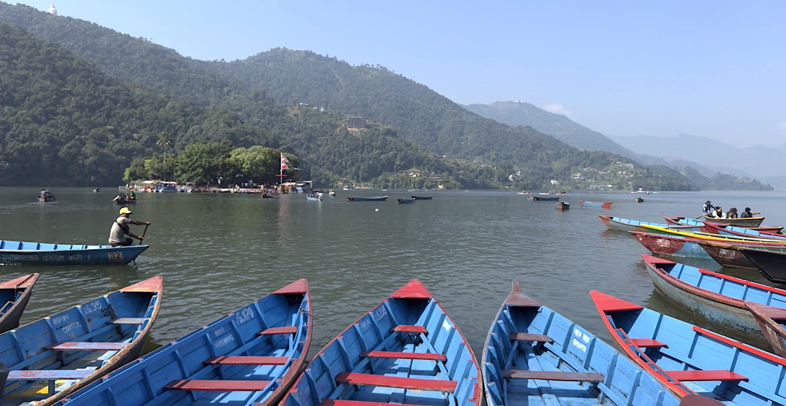
Likewise, your trekking begins at the capital city altitude of Kathmandu, which sits at Kathmandu elevation Nepal baseline of 1,400 meters (4,593 ft). The first part of your trek will be to travel west, to the lake city of Pokhara.
Pokhara – a peaceful lakeside paradise where colorful boats, Phewa Lake, and Himalayan views create unforgettable memories
Actually, it's interesting to note that this phase of the trip will take you nearly 600 vertical meters downward. Pokhara is situated at the lower Pokhara lakeside elevation of only 822 meters (2,696 ft), and the oxygen-rich air at this lower altitude makes for an ideal rest spot where you can relax, rehydrate, and organize your gear before you begin your upward trek.
Staging Transit Logistics :
Kathmandu-Pokhara Flight: The journey is short, with a 25-minute flight taking you over the Himalayas where you will catch your first glimpse of Everest and Annapurna.
Permit verification checkpoint: In Pokhara, your trekking crew will arrange all your permits for ACAP (Annapurna Conservation Area Project) and your TIMS (Trekking Information Management System) card at the local checkpoint before they go any further.
The Oxygen Reserve Boost: This stage at Pokhara will help you fully recover cardiovascularly and saturating your blood stream with oxygen prior to the lung and leg workout in the Himalayas, and gives you a lower-elevation staging zone to prepare for higher altitudes.
The Hike Trailhead Drive: From Pokhara, you will be transported up the windy mountain roads to the active trailhead where your Annapurna Base Camp trek will actually begin-this will likely take place in Nayapul, Hile, or Ghandruk.
Staging Station Node
Altitude Metrics
Barometric Pressure | Main Trek Function
Kathmandu Valley
1,400m / 4,593ft
86% of sea level | international travel, outfit acquisition, and group meetings.
Pokhara Lakefront
822m / 2,696ft
91% of sea level | permit arrangement, porter meeting point, altitude re-adaptation.
Geographic Staging matrix: Kathmandu versus Pokhara
Choosing Your Route: The Rapid Ascent via Jhinu Danda vs. The Acclimatization Loop via Poon Hill
Choosing your route is a very early, key decision. Your layout will determine not only the days you have in the mountain scenery but also the initial, significant vertical gains you’ll have to contend with. There are two basic ways you can go: either climb up the river valley at a faster pace, or head up a west-bound loop for acclimatization purposes.
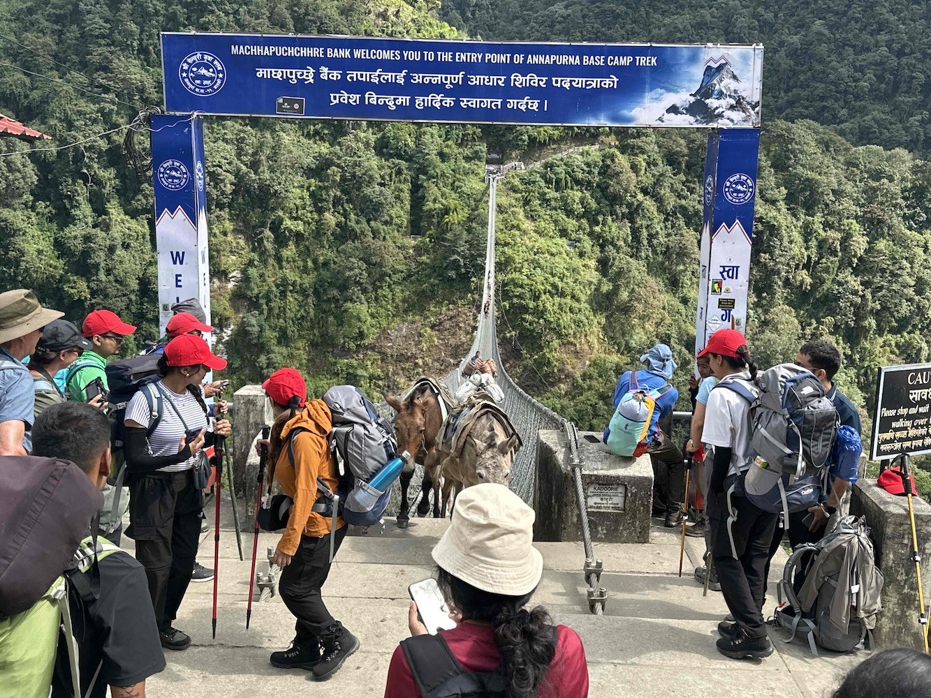
The suspension bridge at Jhinu Danda – an exciting crossing above the river on the way through the beautiful Annapurna foothills.
[Chhomrong Crossroads: 2,170 m]- (Rapid Path up the river) (Acclimatizing loop up west-bound ridge)
In fact, there's one of two different kinds of entry point variations available and they do far more than simply alter your day by day travel distance; they dramatically affect the altitude profile of your trek. This ABC direct route vs Ghorepani route decision will define how physically challenging the initial few days of the ABC trip actually are and how quickly you’ll need your lungs. A fast track through the valley is good for experienced legs with no time, a loop is the safer bet if your lungs aren't prepared for a very rapid, high gain of elevation.
Comparing Trail Route Choices :
The Fastest Track: The direct valley ascent means getting from Pokhara straight to the Jhinu Danda trail, avoiding the west-bound ridges completely so you merge onto the valley trek in either 24 or 48 hours.
The Extended Footprint: The Ghorepani route travels west up into the hills before eventually joining the main river canyon trail. The west-bound loop pushes you to the temporary high point of 3,210 meters on the Poon Hill ridge.
The Muscle Cost: The most appealing part of the direct trail is the saving of days; the disadvantage is the huge vertical loss/gain it will demand of your muscles on day one.
The Safety Measure: The longer Ghorepani loop works as a pre-AC climb by taking several days to move up the western slopes. This builds an awareness within your lungs of how they react to the thinner air at altitude before reaching base camp.
Hours of Trek to Chhomrong | Altitude of Highest point
Demanding element | Recommended For
Rapid Ascent Track
1-2 | 2,170 m / 7,119 ft
Immense vertical gain via stone steps; immense vertical loss | Seasoned trekkers with little time
Acclimatizing Loop
3-4 | 3,210 m / 10,531 ft
Continuous ridge walking over days; requires lung-specific stamina | First-time trekkers; those focusing on views/photography.
Layout of Entrance Paths to Chhomrong (South) :
Scenic Route Option: West-bound loop via Ulleri, Ghorepani, and Poon Hill
This longer route effectively adds a classic mountain trekking experience to the beginning of your trip through the central hills. The trail passes through incredible deep rhododendron forests and across the villages before dropping back down and re-joining the primary sanctuary trail within the valley.
Poon Hill sunrise – watch the Himalayan giants glow in golden light as a new day begins over the Annapurna range.
[Poon Hill peak: 3,210m] The best sunrise destination on this side of the country- (+336m climb for the sunrise)
[Ghorepani village ridge: 2,874 m] where rhododendrons begin- (+824 m mountain climb)
In fact, the most difficult element of the Ghorepani route is its "staircase profile." It will push your muscles with 3000+ hand-cut stone stairs before arriving at the high village of Ghorepani, followed by another sustained climb up to the Poon Hill ridge.
Altitude Break Down on the West-Bound Loop :
The Great Step Climb: From the valley bottom, your trek immediately sends you up the steep, challenging, 3000+ stone stairs from the riverbed to Ulleri village (2,050 m / 6,725 ft).
The Forest ridge: Continuing eastward, the trek becomes more gradual and is characterized by a high, dense forest, eventually reaching the high mountain village of Ghorepani at 2,874 meters ($9,429\text{ ft}$).
The Sunrise peak: For the greatest experience, get up for a pre-dawn climb to Poon Hill (3,210 m / 10,531 ft) for a magnificent sunrise over the Annapurnas and Dhaulagiri ranges.
The Return Path to Main Sanctuary Trail: Descend from Poon Hill back to Ghorepani, and continue trekking east across multiple ridges, down to Tadapani, and finally join the ABC trek's main path through Chhomrong.
Checkpoint
Altitude
Oxygen Density (% of sea level) | Notable Trekking Challenge
Tikhedhunga starting point
1,540 m / 5,052 ft
84% | Mountain stream treks with the river rushing next to you.
Ulleri peak (end of steps)
2,050 m / 6,725 ft
79% | A relentless, vertical ascent through over 3,000 stairs.
Ghorepani village
2,874 m / 9,429 ft
72% | Moderate ridge ascent through dense mountain trees.
Poon Hill summit
3,210 m / 10,531 ft
69% | A brief, sharp ascent over a dirt track to the scenic overlook.
The elevation profile of the Ghorepani loop circuit :
Route Option B: The Express Direct Profile via Matque, Jhinu Danda and Chhomrong
Here, you can choose for a faster, more direct way to get to Annapurna Base Camp with this express route via Matque, Jhinu Danda and Chhomrong. You will have a shorter, more time-efficient profile without sacrificing incredible scenery and cultural experiences. You are driven from Pokhara to the Matque trail-head at 1,500m (4,921 ft). You then begin your hike on fresh legs. The trail rapidly takes you across an immense suspension bridge over the Modi Khola to Jhinu Danda at 1,780m (5,840 ft), where many trekkers choose to relax and soothe muscles in the famous hot springs. From here, the trail steadily ascends steep ridges of terraced fields and forests to the main junction of Chhomrong at 2,140m (7,020 ft).
Fresh legs at a starting elevation of 1,500 m (4,921 ft) with great teahouse access.
Less crowded alternative to the classic Nayapul start.
More time for the upper sections of the trek.
Jhinu Danda and Chhomrong Highlights :
Relaxing natural hot springs at Jhinu Danda at 1,780 m (5,840 ft).
Dramatic suspension bridge crossing with great views.
Steady ridge ascent through terraced farms and forests.
Central meeting point and comfortable teahouse village of Chhomrong at 2,140 m (7,020 ft).
Segment
Elevation
Key Activity | Walking Time
Drive to Matque Trailhead
1,500 m (4,921 ft)
Road Transfer | 2-3 hrs
Matque to Jhinu Danda
Ascent to 1,780 m (5,840 ft)
Bridge Crossing | 2-3 hrs
Jhinu to Chhomrong
Ascent to 2,140 m (7,020 ft)
Steep Ridge Climb | 3-4 hrs
Route Option B Altitude Profile :
Why Choose this Direct Route :
Fastest entry into the main trail network.
Opportunity to take a relaxing dip in the hot springs.
Good altitude gains for a more progressive start to the trek.
Ideal for trekkers with shorter time frames.
In conclusion, Route Option B through Matque, Jhinu Danda and Chhomrong is a brilliant direct profile for those wanting to make the most of their Annapurna Base Camp trek in the shortest amount of time. Get in touch with Haven Holidays today to customize this fantastic route!
The Great Convergence: Navigating the Rollercoaster Ridges of Sinuwa and Bamboo
Meanwhile, this stage sees the routes finally merge into a single exhilarating pathway through Sinuwa and Bamboo, introducing the famous "rollercoaster ridges". From Chhomrong at 2,140 m (7,020 ft), you drop sharply down to the riverbed before climbing straight back up to Upper Sinuwa at 2,360 m (7,743 ft). The challenging undulation continues as you plunge down again to the humid, mossy forest of Bamboo at 2,310 m (7,579 ft). Though tiring, this section builds incredible leg strength for the altitudes ahead. The lush valley of the Modi Khola creates an atmospheric environment with numerous waterfalls and dense flora.
Sinuwa – breathtaking gorge views, dense forests, and magnificent Himalayan mountains guide the journey ahead.
Sinuwa Village Altitude Features :
Upper Sinuwa at 2,360 m (7,743 ft).
Calm village with good teahouse options.
Key rest point after the sharp climb up from the river.
Superb views down the Modi Khola valley.
Bamboo Lodge Elevation Highlights :
Located in the damp, humid forest at 2,310 m (7,579 ft).
Towering bamboo groves and rhododendron trees surround the lodges.
Comfortable overnight stay prior to the steep ascent to Dovan.
Segment
Elevation Change
Terrain Description | Walking Time
Chhomrong to Riverbed
Descent from 2,140 m (7,020 ft)
Steep downhill, forest trail | 1-2 hrs
River to Upper Sinuwa
Ascent to 2,360 m (7,743 ft)
Steep uphill climb | 2-3 hrs
Sinuwa to Bamboo
Descent to 2,310 m (7,579 ft)
Descending, damp forest trail | 1-2 hrs
Rollercoaster Ridges Overview :
Challenges and Rewards of This Section :
Demanding ascents and descents test and build trekking muscles.
The valley's rich greenery and waterfalls make for an immersive trek.
The joining of the two routes brings with it a lively atmosphere on the trail.
Successfully navigating this challenging terrain instills confidence.
To sum up, the great convergence over the rollercoaster ridges of Sinuwa and Bamboo is an unforgettable part of the Annapurna Base Camp trek that both challenges and rewards. Book your trek with Haven Holidays to experience these incredible landscapes with expert guides.
Transitioning the Tree Line: Steady Climb from Dovan to Deurali
As you break through the forest line on the steady ascent from Dovan to Deurali, the air thins and the scenery opens up. This marks a significant change in your Annapurna Base Camp trek, moving from dense woodland to genuine alpine country. The trek follows a gradual gradient up a narrowing valley gorge. After passing the well-known Himalaya Hotel at 2,920 meters (9,580 feet), you continue your ascent to Deurali at 3,200 meters (10,498 feet)
Baraha Temple – a sacred stop along the journey to Annapurna Base Camp, offering peace, culture, and spiritual blessings in the Himalayas.
Actually, this is an important section to allow your body to acclimatize slowly to the increasing altitude. You will see the vegetation gradually changing from trees to low-lying shrubs and grasses as you cross the tree line. This stage also provides magnificent views of the sheer rock walls of the surrounding mountains and a clear indicator that avalanche awareness becomes paramount after Deurali. This portion helps prepare you for the exposed sanctuary path ahead both physically and mentally.
Himalaya Hotel Altitude Features :
A comfortable resting point at 2,920 m (9,580 ft) with excellent teahouses
The last of the large forests before entering the alpine zones
A pleasant spot to take a break along the way during the slow incline
A lovely vista point along the Modi Khola gorge
Deurali Elevation Highlights :
A significant altitude at 3,200 m (10,498 ft)
A definitive shift into the alpine, open mountain environment
A critical point where awareness of potential avalanches becomes vital
A key staging point before continuing up to MBC
Trail Section
Elevation
Key Transitions | Time Taken
Dovan to Himalaya Hotel
Up to 2,920 m (9,580 ft)
Through the wooded valley gorge | 2-3 hours
Himalaya Hotel to Deurali
Up to 3,200 m (10,498 ft)
Crossing tree line to the alpine zone | 2-3 hours
Crossing the Tree Line Summary :
Benefits of Transitioning :
Gradual altitude gain aiding proper acclimatization
A dramatic change in scenery from dense forests to wide open mountains
Building a trekking rhythm and a sense of achievement
Increased awareness of mountain safety factors
In conclusion, the transition from Dovan to Deurali as you cross the forest line provides a fascinating introduction to the alpine world of the Annapurna Sanctuary. This steady climb prepares you wonderfully for the latter parts of your trek. Contact to Haven Holidays today and let us help you experience this awe-inspiring change on your guided trek to Annapurna Base Camp.
Approaching the Gateway: Essential Acclimatization at Machhapuchhre Base Camp (MBC)
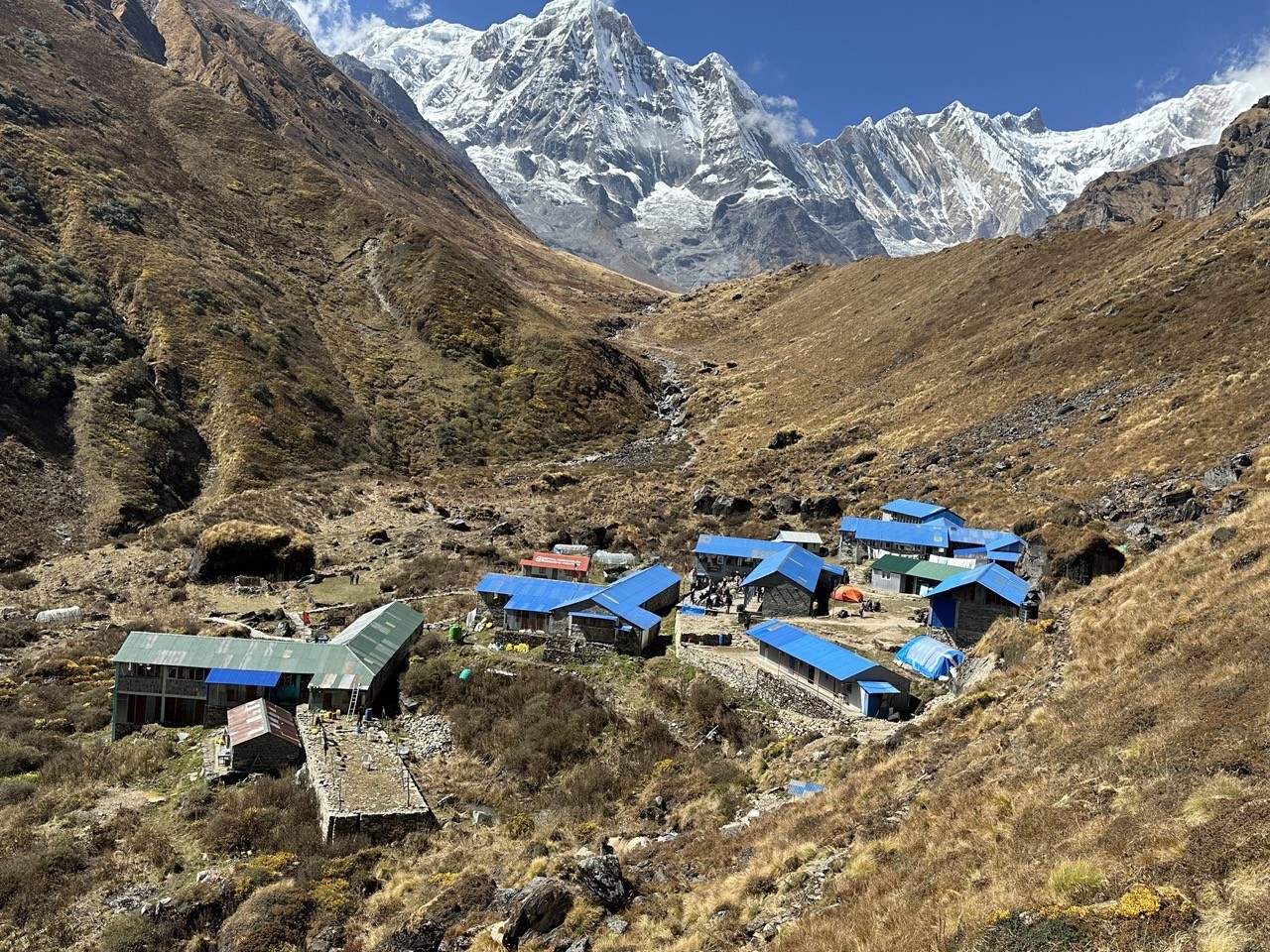
As you enter the stunning Annapurna Sanctuary, you'll reach Machhapuchhre Base Camp, the essential gateway. At 3,700 meters (12,139 feet), this high-altitude station is the perfect place to stop for crucial acclimatization before you make the final ascent to Annapurna Base Camp. The trek from Deurali to MBC takes you through more rugged, rocky terrain, and the imposing peaks seem to press in from every side. Experienced trekkers often spend an entire night here to ensure safe altitude adaptation.
Machhapuchhre Base Camp – a spectacular stop in the Annapurna Sanctuary beneath the legendary Fishtail Mountain.
Likewise, the altitude of Machhapuchhre Base Camp offers an ideal balance. While you sleep at 3,700 m (12,139 ft), you are surrounded by the breathtaking views of the iconic fish-tailed summit of Machhapuchhre at 6,993 meters (22,943 feet). An extra night at this altitude dramatically lowers the chance of altitude sickness during your last day of hiking. Machhapuchhre Base Camp truly acts as the gateway to the sanctuary, setting you up for the magical arrival at Annapurna Base Camp.
Machhapuchhre Base Camp Altitude Advantages
A prime location at 3,700 m (12,139 ft)
The ideal spot to acclimatize to high altitudes safely
Up-close views of the sacred Machhapuchhre peak
Cozy teahouses offering warm meals and drinks
Gateway to the Sanctuary Benefits :
The last significant staging point before Annapurna Base Camp
Gives your body time to adjust before the highest sleeping elevation
An incredible setting surrounded by the sanctuary walls
Heightens your excitement for reaching your final destination
Activity
Elevation
Purpose | Time Duration
Arrival from Deurali
3,700 m (12,139 ft)
Reach the gateway and rest | 3-4 hours
Evening Acclimatization Walk
Brief excursion around MBC
The principle of climbing high, sleeping low | 1-2 hours
Overnight Stay
3,700 m (12,139 ft)
Safely adapt to the high altitude before ABC | Full night
MBC Acclimatization Schedule :
Why MBC Staging is Critical :
It prevents a too-rapid ascent to higher altitude camps
Allows ample time to soak in the magnificent entrance to the sanctuary
Increases your odds of reaching ABC successfully and safely
Provides a true high-mountain experience
In conclusion, Machhapuchhre Base Camp serves as a crucial stopping point for acclimatization, making it a vital part of a safe and rewarding Annapurna Base Camp trek. It ensures you are at your strongest and most prepared for your journey to the sanctuary. Let Haven Holidays plan your complete guided trek today and experience this incredible high-altitude milestone for yourself.
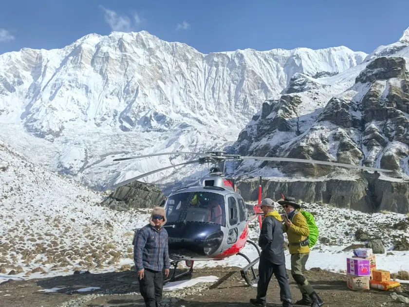
Annapurna Base Camp Trek with Helicopter Return | 4 days
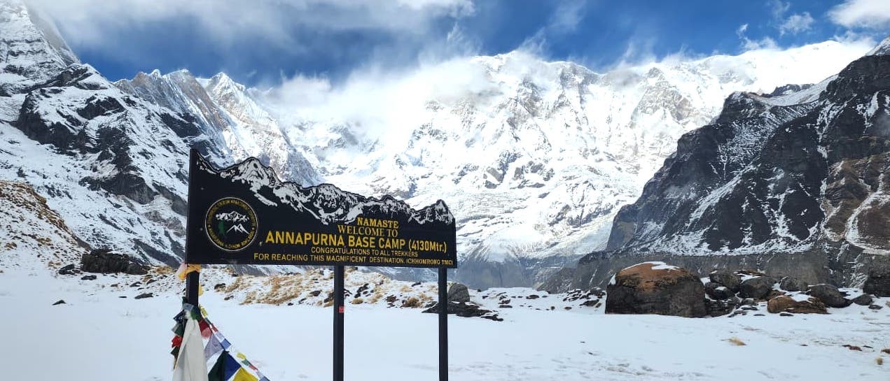
Reaching the Holy Annapurna Base Camp: Standing in the Sanctuary
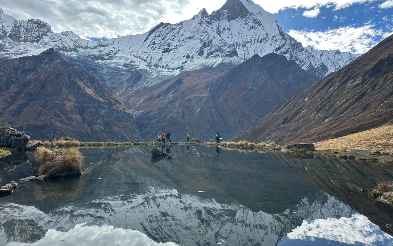
Here, a moment etched in time: arriving in the heart of Annapurna Sanctuary, a bowl of white giants surrounding you. The last morning trek from Machhapuchhre Base Camp takes you triumphantly into this glacial arena. You meander slightly uphill and reach the peak destination of your trek, Annapurna Base Camp, at 4,130m (13,549ft).
Annapurna Base Camp – a proud moment beside the iconic ABC signboard, surrounded by the majestic peaks of the Annapurna Himalayas.
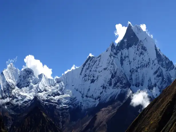
On this sacred high plateau, a 360-degree vista awaits. You are embraced by the immense walls of Annapurna I (8,091m/26,545ft), Annapurna South (7,219m/23,684ft) and Machhapuchhre (6,993m/22,943ft), an intimate dance between man and mountains. Sleeping at base camp offers an almost spiritual communion with these peaks; you feel insignificantly small, yet alive and exhilarated in this amphitheater of ice and rock.
Annapurna Base Camp at its Highest Altitude: Key Points
Elevation of Annapurna Base Camp (ABC): 4,130m (13,549ft)
360-degree view of towering peaks
Sacred site revered by Gurung and Magar locals
A striking glacial bowl, adorned with prayer flags
The ultimate reward for your journey
Final Trek from MBC: A Gradual Ascend
A short, thrilling morning walk from Machhapuchhre Base Camp (3,700m/12,139ft)
A gentle trail through moraine and rocky paths
Views becoming more spectacular with every step
An emotional arrival into the sanctuary
Segment
Elevation
Experience | Walking Time
Machhapuchhre BC to ABC
3,700m - 4,130m (12,139-13,549ft)
Slow climb into a glacial basin | 2-3 hours
Time at Annapurna BC
4,130m (13,549ft)
360-degree views, celebration | 2-4 hours
Overnight Stay at Annapurna BC
4,130m (13,549ft)
Sleeping at base camp, among the giants | Full night
ABC Arrival: An Overview
Al in all, standing on this sanctuary, Annapurna Base Camp is the culmination of your trekking journey. Its maximum altitude and awe-inspiring setting make every step worthwhile. Contact Haven Holidays today to book your guided Annapurna Base Camp trek and create memories that will last a lifetime. (365 words)
The Genius of No "Rest Day": Adapting Naturally on Annapurna Base Camp
Actually, the Annapurna Base Camp trek is renowned for not featuring a stationary "rest day" like the one you'd typically find on Everest Base Camp treks. This unique approach relies on the inherent power of gradual mountain incline. As you ascend steadily through deep valleys and along ridges, your body naturally adapts physiologically to the altitude. This built-in acclimatization strategy means a dedicated rest day is often unnecessary for healthy trekkers.
Although the Ghorepani- Poon Hill route adds more days of trekking and thousands of stairs, it excels in natural acclimatization. The direct route, on the other hand, is much faster but presents a more aggressive altitude profile. Therefore, vigilant pacing and adequate hydration are crucial for preventing altitude sickness on the ABC trek. Furthermore, the trail's passage through forests and valleys facilitates better oxygen absorption compared to rapid, high-altitude ascents.
Annapurna Base Camp Trek: Altitude Sickness Prevention
Slow daily elevation increases promote natural acclimatization. Multiple nights at moderate altitudes build red blood cell production. Continuous physical activity aids circulation, lowering AMS risk. Experienced guides monitor trekkers for any signs of altitude sickness. Flexible itinerary allows for additional rest when required.
Benefits of Gradual Acclimatization:
The Modi Khola valley's steady incline supports natural adaptation. No formal rest day is needed due to consistent progress. Trekking days and recovery nights are effectively integrated. Especially effective on longer treks like Poon Hill. Emphasizes active acclimatization over static rest.
Trek Type
Acclimatization Method
Key Advantage | Altitude Sickness Risk
Ghorepani / Poon Hill route
Excellent natural adaptation
More days + stairs | Low
Direct route (via Jhinu Danda)
Aggressive altitude gain
Time-saving, steeper ascent | Moderate
Annapurna Base Camp trail
Steady valley incline
Built-in daily adaptation | Manageable
Comparing Altitude Progression Styles :
In summary, the gradual mountain incline on the Annapurna Base Camp trek ensures effective acclimatization without the need for a formal rest day. This intelligent design, coupled with careful pacing, keeps you safe and strong throughout your journey. Contact Haven Holidays today to find the perfect Annapurna Base Camp itinerary for your fitness level.
The Rapid Return to Acclimatize and Recharge: The Jhinu Hot Springs Trek
Here, rejoice in your incredible accomplishment at Annapurna Base Camp, and then start the swift downward journey that will provide much-needed relief to your body. Since the highest sanctuary is at the end of the valley, the journey down is a return to where you began. You will descend a total of over 2,300 meters in only two days. This rapid, but comfortable, descent will provide immediate oxygen and a welcome break to your aching limbs.
Likewise, the trail will lead you back down through Machhapuchhre Base Camp, Deurali, and down the Modi Khola Valley. You'll pass through places like Bamboo, and Sinuwa much more easily this time. More importantly, your knees will bear the greatest load during the trek down. Thus, trekking poles and consistent pace are crucial to avoiding knee pain, and every meter lost allows for faster progress with more abundant oxygen filling your lungs.
Benefits of Natural Hot Springs Recovery :
Relax on natural hot springs by the river in Jhinu Danda (1,780 m / 5,840 ft)
Experience rapid muscle recovery following the strenuous high-altitude trek
Melt away aches and pains with warm mineral waters
A rewarding end to the trek
Recharge your batteries before the final leg to Pokhara
Tips for a Safe Descent :
Use trekking poles on steep sections to relieve pressure on your knees
Walk at a steady, consistent pace to avoid overexerting joints
Stay hydrated even though you are going downhill
Enjoy the scenery as you recognize familiar landmarks from a new perspective
Relax and enjoy the natural hot springs in Jhinu Danda after a hard trek
Segment
Elevation Drop
Key Experience | Walking Time
ABC to MBC / Deurali
4,130m to 3,200m (13,549ft - 10,498ft)
Oxygen boost, familiar trail | 4-5 hours
Deurali to Bamboo / Sinuwa
Continued descent
Forest trek, easier breathing | 5-6 hours
Final descent to Jhinu
To 1,780m (5,840ft)
Hot Springs Relaxation | 4-5 hours
Descent Elevation Profile :
In concluding lines, the swift and restorative journey from ABC to the natural hot springs of Jhinu Danda is a smart way to end your trek. It balances physical recovery with natural beauty, providing a well-deserved treat after reaching the ultimate destination. Plan your full guided ABC trek with safe descent planning by contacting Haven Holidays today!
Master Altitude Summary: Your Ultimate Annapurna Base Camp Trek Guide
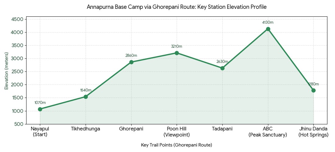
With this quick, practical master altitude summary, you can choose the best Annapurna Base Camp trek for you with complete confidence. Both the classic Ghorepani loop and the direct Jhinu Danda itinerary reach the same majestic destination, but they offer very different hiking and acclimatization experiences. This easy-to-understand quick reference guide will give you the information you need to plan your trek and set your expectations.
Although the Ghorepani route takes several days longer and includes many thousands of stairs, it offers superior natural acclimatization. The faster Jhinu Danda route is much more aggressive on your altitude. In the end, your selection depends entirely upon your current fitness level, available time, and the condition of your knees. This compact itinerary planner simplifies this choice with an easily accessible format.
Day
Key Point | Elevation
Walking Hours | Distance (approx)
1
Nayapul to Tikhedhunga| 1,070m - 1,540m (3,510-5,052ft)
4-5 hrs | 8 km
2
To Ghorepani | To 2,860m (9,383ft)
6-7 hrs | 10 km
3
Poon Hill + to Tadapani| 3,210m viewpoint
6 hrs | 9 km
4-8
To ABC | Peak 4,130m (13,549ft)
5-7 hrs/day | -
9-10
Descent to Jhinu | To 1,780m (5,840ft)
5-6 hrs | -
ABC Day-by-Day Elevation - Ghorepani Route :
Day
Key Point | Elevation
Walking Hours | Distance (approx)
1
Jhinu Danda to Chhomrong | 1,780m - 2,140m (5,840-7,020ft)
5-6 hrs | 10 km
2-3
Rollercoaster to Deurali | To 3,200m (10,498ft)
5-6 hrs | 9-11 km
4
To MBC | 3,700m (12,139ft)
4-5 hrs | 8 km
5
Reach ABC | 4,130m (13,549ft)
2-3 hrs | 5 km
6-7
Descent to Jhinu | To 1,780m (5,840ft)
5-6 hrs | -
ABC Day-by-Day Elevation - Direct Jhinu Route
In conclusion, this master altitude summary table is your ultimate quick reference guide to planning the ideal ABC trek. Both trekking routes offer a rewarding and unforgettable experience, provided you prepare properly. To customize your perfect Annapurna Base Camp itinerary based on your individual fitness level and schedule, contact Haven Holidays today.
Getting your climb up the Annapurna Base Camp trek altitude profile right is key to a safe and successful expedition. The trek has unique vertical variances as it snakes upward through the depths of a steep river gorge, before reaching a vast glacial amphitheater high up in the Himalayas.
Annapurna Base Camp Trek Elevation Profile- FAQs
1. What is the starting altitude for the Annapurna Base Camp trek? The traditional start altitude of the Annapurna Base Camp trek begin in Nayapul, sitting at 1,070 meters. However, modern ABC trek itineraries will often use 4x4 jeeps to reach trailheads like Jhinu Danda or Matque, pushing the initial elevation profile up to about 1,500 meters.
2. What is the maximum Annapurna Base Camp altitude? The highest altitude point on this trek is the Annapurna Base Camp altitude at 4,130 meters (13,549 feet) above sea level. This high glacial basin is the highest sleep point on the trek, serving as the basecamp.
3. What are the lowest and highest altitude points of the trek? The range of altitude levels along the entire trek profile is varied, ranging from 1,070 meters on the riverbed near Nayapul, to the ABC altitude of 4,130 meters on its own.
4. What is the average daily altitude gain and loss on the ABC trek? The altitude gain and loss experienced during the daily hike will be quite pronounced; trekkers gain an average of 400 to 700 meters in elevation per day but this will be paired with extremely steep downhill segments on rocky stone stairs.
5. How does the Annapurna Base Camp altitude compare to Everest Base Camp? With a peak of 4,130 meters, the Annapurna Base Camp elevation is significantly lower than that of Everest Base Camp (5,364m). Because it stays under 4,500m, the atmospheric conditions at ABC are more favorable with much less severe atmospheric pressure and a significantly easier acclimatization process.
6. How common is altitude sickness on the Annapurna Base Camp trek? Although the Annapurna Base Camp altitude is considered quite manageable when compared to higher routes, you can still experience symptoms of Acute Mountain Sickness (AMS) once past 3,000 meters. Acclimatization days, slow pacing, and constant hydration are the primary ways to prevent sickness as you trek to the sanctuary.
7. What is the altitude profile of Machhapuchhre Base Camp? Machhapuchhre Base Camp is high up on the Annapurna Base Camp altitude profile at 3,700 meters (12,139 feet). Often trekkers sleep overnight at Machhapuchhre Base Camp, or it will serve as a lunch stop on the final push to the base camp.
8. How sudden is the altitude variation when climbing to Sinuwa? The trek to Sinuwa presents a prime example of a sharp daily altitude gain and loss. You must descend hundreds of steps down to the Chomrong River (1,860m) and then immediately climb a steep wall up to Upper Sinuwa (2,360m).
9. What is the altitude profile of Deurali on the ABC trek route? The highest sleeping point on the ABC trek before Annapurna Base Camp is Deurali (3,200m). This point is key to helping your body acclimatize as you enter the alpine region and is a favorite resting point.
10. Does the forest zone impact the air quality of the ABC trek? Yes, the rich oxygen in the deep rhododendron and bamboo forests below 3,000 meters offers good quality air. Beyond Himalaya (2,920m), as the vegetation becomes sparser alpine shrubland, the air feels significantly thinner as you move through the higher ABC altitude profile.
11. Is the Annapurna Base Camp trek altitude suitable for beginners? The Annapurna Base Camp trek is achievable for fit beginners with its gentle climbing profile from a low start altitude and moderate peak, making it one of the safer and more beginner-friendly treks.
12. What is the total distance of a typical ABC trek? The ABC trek itinerary from start to finish is typically 65 to 80 kilometers, although this can vary depending on starting and ending points. Trekkers manage this distance through a combination of slow upward climbing and continuous downhill shifts on the terrain.
13. How does the steep terrain influence temperature? The intense climbing profile leads to drastic temperature fluctuations on the trek. While the lodges on the lower portions of the trek with a lower starting elevation enjoy warmer temperatures, night time temperatures at the ultimate Annapurna Base Camp elevation will regularly drop below 0 C.
14. What is the altitude profile of Chomrong village? Chomrong is a stunning Gurung village set high up in a terraced slope and offers one of the best views of the Annapurna range. Situated at an altitude of 2,170 meters (7,119 ft), this is a very important point as all variations of the Annapurna Base Camp trek converge here before heading down into the gorge.
15. What does "climb high, sleep low" mean on the Annapurna trek? Guides often employ the 'climb high, sleep low' tactic on the Annapurna trek, whereby trekkers push to higher elevations than their lodging point during the day (to boost red blood cells and acclimatization), before trekking slightly lower for the night. For example, a trekger may climb higher than Deurali (3,200m) then trek down to a lower village profile for sleep.
16. Are there any difficult mountain passes on the standard Annapurna trek? No, the traditional ABC trek trail does not have high or glaciated mountain passes, nor does it have the treacherous terrain often found when crossing ranges high up in the Himalayas like the Annapurna Circuit or the trek to Thorong La. Instead, you will only have valley floor trails to navigate through.
17. How does the amount of oxygen change at the summit of the Annapurna trek? While at the valley's starting altitude, trekkers receive 100% oxygen, at the Annapurna Base Camp elevation of 4,130 meters effective oxygen drops to about 60%, leading to a shortage of breath and exhaustion during exercise.
18. Is travel insurance mandatory for the Annapurna Base Camp elevation? Yes, specialised travel insurance is required for trekking at high altitudes such as the Annapurna Base Camp elevation. Ensure it covers emergency medical expenses and helicopter rescue up to at least 4,500m as protection from serious health issues such as altitude sickness.
19. How quickly will you descend from Annapurna Base Camp? The descent from ABC is exceptionally fast; in one day, you will drop over 1800 meters in elevation from the Annapurna Base Camp altitude to Bamboo (2,310m) due to breathing thicker air after long term exposure at high altitude. This can make for a challenging return journey.
20. What is the success rate of the Annapurna Base Camp trek? The Annapurna Base Camp trek has a high success rate of 95-98 percent, due to its relatively gentle climb profile and moderate peak Annapurna Base Camp elevation, making it very accessible and safe to reach the base camp.