[{"name":"Everest Base Camp Helicopter Tour","duration":"1","image_url":"https:\/\/www.havenholidaysnepal.com\/storage\/trip-galleries\/1\/thumb_6cd53005d75a86e373d31419d1b14d78.webp","offer_price":1195,"url":"https:\/\/www.havenholidaysnepal.com\/trips\/everest-base-camp-helicopter-tour"},{"name":"Everest Mountain Flight","duration":"1","image_url":"https:\/\/www.havenholidaysnepal.com\/storage\/trip-galleries\/4\/thumb_3b0b4f1d6f72b0ad224daf4752f2c6e0.jpg","offer_price":285,"url":"https:\/\/www.havenholidaysnepal.com\/trips\/everest-mountain-flight"},{"name":"Everest Short Trek","duration":"9","image_url":"https:\/\/www.havenholidaysnepal.com\/storage\/trip-galleries\/5\/thumb_BXPP3621.JPEG0.02033800 1727957098.webp","offer_price":995,"url":"https:\/\/www.havenholidaysnepal.com\/trips\/everest-short-trek"},{"name":"Gokyo Valley Trek","duration":"12","image_url":"https:\/\/www.havenholidaysnepal.com\/storage\/trip-galleries\/6\/thumb_10bc469b14731f23d3ce84a7092ad53f.jpg","offer_price":1195,"url":"https:\/\/www.havenholidaysnepal.com\/trips\/gokyo-valley-trek"},{"name":"15 days Annapurna Base Camp Trek","duration":"15","image_url":"https:\/\/www.havenholidaysnepal.com\/storage\/trip-galleries\/7\/thumb_87d1533bc45faf070990aef0579e4be4.jpg0.81855100 1728285496.webp","offer_price":785,"url":"https:\/\/www.havenholidaysnepal.com\/trips\/15-days-annapurna-base-camp-trek"},{"name":"Nepal Pilgrimage Tour","duration":"14","image_url":"https:\/\/www.havenholidaysnepal.com\/storage\/trip-galleries\/8\/thumb_02c3bcf2ad2e8a4c1703e90ae747b5f1.jpg","offer_price":1475,"url":"https:\/\/www.havenholidaysnepal.com\/trips\/nepal-pilgrimage-tour"},{"name":"UNESCO World Heritage Site Tour","duration":"10","image_url":"https:\/\/www.havenholidaysnepal.com\/storage\/trip-galleries\/9\/thumb_unesco-world-heritage-site-Lumbani-temple-buddhists-hindus-kathmandu-nepal0.36988600 17347617740.93089500 1737469667.webp","offer_price":715,"url":"https:\/\/www.havenholidaysnepal.com\/trips\/unesco-world-heritage-site-tour"},{"name":"Island Peak Climbing","duration":"16","image_url":"https:\/\/www.havenholidaysnepal.com\/storage\/trip-galleries\/11\/thumb_Island peak0.53947000 1734692503.webp","offer_price":2495,"url":"https:\/\/www.havenholidaysnepal.com\/trips\/island-peak-climbing"},{"name":"Upper Mustang Trek","duration":"18","image_url":"https:\/\/www.havenholidaysnepal.com\/storage\/trip-galleries\/12\/thumb_upper mustang 7 Oct-2024.jpg0.95398900 1728286166.webp","offer_price":2995,"url":"https:\/\/www.havenholidaysnepal.com\/trips\/upper-mustang-trek"},{"name":"Annapurna Circuit Trek","duration":"16","image_url":"https:\/\/www.havenholidaysnepal.com\/storage\/trip-galleries\/15\/thumb_tibetan-flags.jpg0.04843900 1728289138.webp","offer_price":985,"url":"https:\/\/www.havenholidaysnepal.com\/trips\/annapurna-circuit-trek"},{"name":"Gosainkunda Lake Trek","duration":"10","image_url":"https:\/\/www.havenholidaysnepal.com\/storage\/trip-galleries\/16\/thumb_5A8083B3-C007-41A8-853F-D0C37C97D235_1_105_c.jpeg0.52581200 1731845258.webp","offer_price":595,"url":"https:\/\/www.havenholidaysnepal.com\/trips\/gosainkunda-lake-trek"},{"name":"Zip-lining in Pokhara and Dhulikhel","duration":"1","image_url":"https:\/\/www.havenholidaysnepal.com\/storage\/trip-galleries\/18\/thumb_215f765e2ebc995dd5c800b4bfdbacc3.jpg","offer_price":82,"url":"https:\/\/www.havenholidaysnepal.com\/trips\/zip-lining-in-pokhara-and-dhulikhel"},{"name":"Annapurna Heli Tour","duration":"1","image_url":"https:\/\/www.havenholidaysnepal.com\/storage\/trip-galleries\/19\/thumb_d71a6bbb9fd4da8d1b567a5cdbdec85d.jpg","offer_price":555,"url":"https:\/\/www.havenholidaysnepal.com\/trips\/annapurna-heli-tour"},{"name":"Paragliding in Pokhara","duration":"1","image_url":"https:\/\/www.havenholidaysnepal.com\/storage\/trip-galleries\/20\/thumb_de788d2dd9726783431f882c007efae1.jpg","offer_price":65,"url":"https:\/\/www.havenholidaysnepal.com\/trips\/paragliding-in-pokhara"},{"name":"Ultra-Flight in Pokhara","duration":"1","image_url":"https:\/\/www.havenholidaysnepal.com\/storage\/trip-galleries\/21\/thumb_e27a9fb572a5c21611bb2a3c18e4b8f0.jpeg","offer_price":175,"url":"https:\/\/www.havenholidaysnepal.com\/trips\/ultra-flight-in-pokhara"},{"name":"Sarangkot Hiking","duration":"1","image_url":"https:\/\/www.havenholidaysnepal.com\/storage\/trip-galleries\/22\/thumb_100ef822fea19987166c6c1366215f15.jpg","offer_price":55,"url":"https:\/\/www.havenholidaysnepal.com\/trips\/sarangkot-hiking"},{"name":"Mera Peak Climbing","duration":"18","image_url":"https:\/\/www.havenholidaysnepal.com\/storage\/trip-galleries\/24\/thumb_d16ae3895f678cf26ffbf2455f541fb5.jpg0.31883400 1732617790.webp","offer_price":2475,"url":"https:\/\/www.havenholidaysnepal.com\/trips\/mera-peak-climbing"},{"name":"Lower Dolpo Trek","duration":"18","image_url":"https:\/\/www.havenholidaysnepal.com\/storage\/trip-galleries\/26\/thumb_Dolpo Galary - 1.JPG0.37725200 1727939952.webp","offer_price":2995,"url":"https:\/\/www.havenholidaysnepal.com\/trips\/lower-dolpo-trek"},{"name":"Nagarkot Sunrise\/Sunset Tour","duration":"1","image_url":"https:\/\/www.havenholidaysnepal.com\/storage\/trip-galleries\/27\/thumb_5147a5532644283a380f2e86f3857c13.jpg0.17748000 1728488108.webp","offer_price":30,"url":"https:\/\/www.havenholidaysnepal.com\/trips\/nagarkot-sunrise-sunset-tour"},{"name":"16 day Everest Base Camp Trek","duration":"16","image_url":"https:\/\/www.havenholidaysnepal.com\/storage\/trip-galleries\/28\/thumb_IMG_4311.JPG0.64984800 1727942213.webp","offer_price":1475,"url":"https:\/\/www.havenholidaysnepal.com\/trips\/16-day-everest-base-camp-trek"},{"name":"Ghorepani Poon Hill trek with Jungle Safari and Trishuli River Rafting -13 days","duration":"13","image_url":"https:\/\/www.havenholidaysnepal.com\/storage\/trip-galleries\/29\/thumb_Ghorepani Poon hill.jpg0.48460800 1728281439.webp","offer_price":795,"url":"https:\/\/www.havenholidaysnepal.com\/trips\/ghorepani-poon-hill-trek-with-jungle-safari-and-trishuli-river-rafting--13-days"},{"name":"Mardi Himal Trek","duration":"12","image_url":"https:\/\/www.havenholidaysnepal.com\/storage\/trip-galleries\/30\/thumb_s1.jpg0.62112600 1728200721.webp","offer_price":795,"url":"https:\/\/www.havenholidaysnepal.com\/trips\/mardi-himal-trek"},{"name":"Langtang Valley Trekking","duration":"10","image_url":"https:\/\/www.havenholidaysnepal.com\/storage\/trip-galleries\/31\/thumb_IMG_4702.JPG0.84916500 1727958504.webp","offer_price":685,"url":"https:\/\/www.havenholidaysnepal.com\/trips\/langtang-valley-trekking"},{"name":"Real Adventure Tour in Nepal","duration":"9","image_url":"https:\/\/www.havenholidaysnepal.com\/storage\/trip-galleries\/32\/thumb_ebd1b8cc78d90abe8b9003dd9a2f25bf.jpg0.82151300 1728213516.webp","offer_price":695,"url":"https:\/\/www.havenholidaysnepal.com\/trips\/real-adventure-tour-in-nepal"},{"name":"Luxury Tour in Nepal","duration":"10","image_url":"https:\/\/www.havenholidaysnepal.com\/storage\/trip-galleries\/33\/thumb_8574e61b252b18676b042caf30d830df.jpg","offer_price":1675,"url":"https:\/\/www.havenholidaysnepal.com\/trips\/luxury-tour-in-nepal"},{"name":"Luxury Everest Panorama Trek With EBC Heli Sightseeing","duration":"8","image_url":"https:\/\/www.havenholidaysnepal.com\/storage\/trip-galleries\/34\/thumb_URZL2397.JPEG0.01209600 1728027820.webp","offer_price":2575,"url":"https:\/\/www.havenholidaysnepal.com\/trips\/luxury-everest-panorama-trek-with-ebc-heli-sightseeing"},{"name":"13 day Everest Base Camp Trek with Helicopter","duration":"13","image_url":"https:\/\/www.havenholidaysnepal.com\/storage\/trip-galleries\/35\/thumb_IMG_4292.JPG0.70131500 1728029276.webp","offer_price":2095,"url":"https:\/\/www.havenholidaysnepal.com\/trips\/13-day-everest-base-camp-trek-with-helicopter"},{"name":"Manaslu Circuit Trek","duration":"16","image_url":"https:\/\/www.havenholidaysnepal.com\/storage\/trip-galleries\/36\/thumb_Mt Manaslu 03-Oct-2024.jpg0.65804900 1727938470.webp","offer_price":955,"url":"https:\/\/www.havenholidaysnepal.com\/trips\/manaslu-circuit-trek"},{"name":"Kanchenjunga Base Camp Trek","duration":"21","image_url":"https:\/\/www.havenholidaysnepal.com\/storage\/trip-galleries\/37\/thumb_Kanchanjunga Trek -!.jpg0.54744400 1727938497.webp","offer_price":2275,"url":"https:\/\/www.havenholidaysnepal.com\/trips\/kanchenjunga-base-camp-trek"},{"name":"Ganesh Himal and Sing-La Trek","duration":"18","image_url":"https:\/\/www.havenholidaysnepal.com\/storage\/trip-galleries\/38\/thumb_Ganesh Himal slider-1.jpg0.43764500 1727937722.webp","offer_price":2975,"url":"https:\/\/www.havenholidaysnepal.com\/trips\/ganesh-himal-and-sing-la-trek"},{"name":"Island Peak Climb with Everest Base Camp Trek","duration":"21","image_url":"https:\/\/www.havenholidaysnepal.com\/storage\/trip-galleries\/39\/thumb_2be428730fe83525bc85a010564f99de.jpg","offer_price":2750,"url":"https:\/\/www.havenholidaysnepal.com\/trips\/island-peak-climb-with-everest-base-camp-trek"},{"name":"Students' Adventure Tour in Nepal","duration":"12","image_url":"https:\/\/www.havenholidaysnepal.com\/storage\/trip-galleries\/41\/thumb_a926d22fbfe08cba271c41ac289b3fd2.jpg","offer_price":995,"url":"https:\/\/www.havenholidaysnepal.com\/trips\/students-adventure-tour-in-nepal"},{"name":"7 Day Poonhill Trek","duration":"7","image_url":"https:\/\/www.havenholidaysnepal.com\/storage\/trip-galleries\/42\/thumb_6196bd69036473293a2c24cc21ed57d7.jpg0.10880600 1728205378.webp","offer_price":555,"url":"https:\/\/www.havenholidaysnepal.com\/trips\/7-day-poonhill-trek"},{"name":"7 Days Annapurna Base Camp Trek","duration":"7","image_url":"https:\/\/www.havenholidaysnepal.com\/storage\/trip-galleries\/43\/thumb_IMG_2214.JPG0.08204900 1728202033.webp","offer_price":355,"url":"https:\/\/www.havenholidaysnepal.com\/trips\/7-days-annapurna-base-camp-trek"},{"name":"3 days Poonhill Trek","duration":"3","image_url":"https:\/\/www.havenholidaysnepal.com\/storage\/trip-galleries\/44\/thumb_Poon hill.jpg0.60816600 1731412954.webp","offer_price":165,"url":"https:\/\/www.havenholidaysnepal.com\/trips\/3-days-poonhill-trek"},{"name":"Poon Hill Luxury Trek with Chitwan-12 days","duration":"12","image_url":"https:\/\/www.havenholidaysnepal.com\/storage\/trip-galleries\/45\/thumb_Poom hill.jpg0.52074500 1730180532.webp","offer_price":1175,"url":"https:\/\/www.havenholidaysnepal.com\/trips\/poon-hill-luxury-trek-with-chitwan-12-days"},{"name":"Everest Luxury Trek-7 days","duration":"7","image_url":"https:\/\/www.havenholidaysnepal.com\/storage\/trip-galleries\/46\/thumb_ACRX9330.JPEG0.93236200 1728031275.webp","offer_price":1975,"url":"https:\/\/www.havenholidaysnepal.com\/trips\/everest-luxury-trek-7-days"},{"name":"Hindu Pilgrimage Tour in Nepal-10 days","duration":"10","image_url":"https:\/\/www.havenholidaysnepal.com\/storage\/trip-galleries\/47\/thumb_a94bf96a4d31decb419f6f828a3280d2.jpg","offer_price":995,"url":"https:\/\/www.havenholidaysnepal.com\/trips\/hindu-pilgrimage-tour-in-nepal-10-days"},{"name":"Everest Base Camp Short Trek-12 days","duration":"12","image_url":"https:\/\/www.havenholidaysnepal.com\/storage\/trip-galleries\/48\/thumb_IMG_4311.JPG0.52680100 1727945154.webp","offer_price":995,"url":"https:\/\/www.havenholidaysnepal.com\/trips\/everest-base-camp-short-trek-12-days"},{"name":"Everest Base Camp Hike 12 Days","duration":"12","image_url":"https:\/\/www.havenholidaysnepal.com\/storage\/trip-galleries\/49\/thumb_IMG_4260.JPG0.51729100 1728061234.webp","offer_price":1295,"url":"https:\/\/www.havenholidaysnepal.com\/trips\/everest-base-camp-hike-12-days"},{"name":"11 Days Everest Base Camp Trek","duration":"11","image_url":"https:\/\/www.havenholidaysnepal.com\/storage\/trip-galleries\/50\/thumb_IMG_4249.JPG0.21392500 1727946959.webp","offer_price":985,"url":"https:\/\/www.havenholidaysnepal.com\/trips\/11-days-everest-base-camp-trek"},{"name":"6 Days Annapurna Base Camp Trek","duration":"6","image_url":"https:\/\/www.havenholidaysnepal.com\/storage\/trip-galleries\/51\/thumb_6 days Abc.jpg0.58185400 1728200798.webp","offer_price":285,"url":"https:\/\/www.havenholidaysnepal.com\/trips\/6-days-annapurna-base-camp-trek"},{"name":"Annapurna Base Camp Trek","duration":"8","image_url":"https:\/\/www.havenholidaysnepal.com\/storage\/trip-galleries\/52\/thumb_IMG_2214.JPG0.29415700 1729487656.webp","offer_price":585,"url":"https:\/\/www.havenholidaysnepal.com\/trips\/annapurna-base-camp-trek"},{"name":"Everest Base Camp Trek with Helicopter Fly Out 10 Days","duration":"10","image_url":"https:\/\/www.havenholidaysnepal.com\/storage\/trip-galleries\/53\/thumb_IMG_4328.JPG0.52056600 1728058444.webp","offer_price":1875,"url":"https:\/\/www.havenholidaysnepal.com\/trips\/everest-base-camp-trek-with-helicopter-fly-out-10-days"},{"name":"Everest Base Camp Trek 14 Days","duration":"14","image_url":"https:\/\/www.havenholidaysnepal.com\/storage\/trip-galleries\/54\/thumb_Everest Base Camp Trek 14 days Oct 3 2024.JPG0.43202700 1727939745.webp","offer_price":1455,"url":"https:\/\/www.havenholidaysnepal.com\/trips\/everest-base-camp-trek-14-days"},{"name":"ABC Trek with Poonhill 11 Days","duration":"11","image_url":"https:\/\/www.havenholidaysnepal.com\/storage\/trip-galleries\/55\/thumb_ABC with fishtail.JPG0.21441100 1728277965.webp","offer_price":555,"url":"https:\/\/www.havenholidaysnepal.com\/trips\/abc-trek-with-poonhill-11-days"},{"name":"Muldai Hill Trek 9 Days","duration":"9","image_url":"https:\/\/www.havenholidaysnepal.com\/storage\/trip-galleries\/56\/thumb_7efee59f0a8c6817c8255bd2b9f3539d.jpeg0.19479300 1728213091.webp","offer_price":675,"url":"https:\/\/www.havenholidaysnepal.com\/trips\/muldai-hill-trek-9-days"},{"name":"Mardi Himal Trek 6 days","duration":"6","image_url":"https:\/\/www.havenholidaysnepal.com\/storage\/trip-galleries\/57\/thumb_slider 1.jpeg0.36909700 1728184981.webp","offer_price":590,"url":"https:\/\/www.havenholidaysnepal.com\/trips\/mardi-himal-trek-6-days"},{"name":"Mardi Himal Trek 7 days","duration":"7","image_url":"https:\/\/www.havenholidaysnepal.com\/storage\/trip-galleries\/58\/thumb_slider1.jpg0.61666600 1728206414.webp","offer_price":620,"url":"https:\/\/www.havenholidaysnepal.com\/trips\/mardi-himal-trek-7-days"},{"name":"Mardi Himal Trek 8 Days","duration":"8","image_url":"https:\/\/www.havenholidaysnepal.com\/storage\/trip-galleries\/59\/thumb_sli1.jpg0.38569100 1728206631.webp","offer_price":695,"url":"https:\/\/www.havenholidaysnepal.com\/trips\/mardi-himal-trek-8-days"},{"name":"14 Days Manaslu Trek","duration":"14","image_url":"https:\/\/www.havenholidaysnepal.com\/storage\/trip-galleries\/60\/thumb_sunrise-mt-manaslu-during-manaslu-circuit-larke-pass-trekking-himalaya-nepal (1)0.81855800 1738673284.webp","offer_price":885,"url":"https:\/\/www.havenholidaysnepal.com\/trips\/14-days-manaslu-trek"},{"name":"Dhampus-Sarangkot Trek with Chitwan 8 days","duration":"8","image_url":"https:\/\/www.havenholidaysnepal.com\/storage\/trip-galleries\/61\/thumb_Sarangkot Bhangyang.jpg0.75461400 1728210333.webp","offer_price":790,"url":"https:\/\/www.havenholidaysnepal.com\/trips\/dhampus-sarangkot-trek-with-chitwan-8-days"},{"name":"7 Days Golden Triangle Tour","duration":"7","image_url":"https:\/\/www.havenholidaysnepal.com\/storage\/trip-galleries\/62\/thumb_311ce1d117ee0ba75402a7c301bcdf830.73532400 1739179809.webp","offer_price":845,"url":"https:\/\/www.havenholidaysnepal.com\/trips\/7-days-golden-triangle-tour"},{"name":"Annapurna Circuit Trek 12 days","duration":"12","image_url":"https:\/\/www.havenholidaysnepal.com\/storage\/trip-galleries\/63\/thumb_IMG_20161024_092237.jpg0.57796600 1728289938.webp","offer_price":695,"url":"https:\/\/www.havenholidaysnepal.com\/trips\/annapurna-circuit-trek-12-days"},{"name":"Everest Base Camp Budget Trek 16 Days","duration":"16","image_url":"https:\/\/www.havenholidaysnepal.com\/storage\/trip-galleries\/64\/thumb_IMG_4423.JPG0.92579200 1728144669.webp","offer_price":958,"url":"https:\/\/www.havenholidaysnepal.com\/trips\/everest-base-camp-budget-trek-16-days"},{"name":"Poonhill Budget Trek 7 Days","duration":"7","image_url":"https:\/\/www.havenholidaysnepal.com\/storage\/trip-galleries\/65\/thumb_5be067852d0c5228d6f3155bc425c6b5.jpg","offer_price":395,"url":"https:\/\/www.havenholidaysnepal.com\/trips\/poonhill-budget-trek-7-days"},{"name":"Annapurna Base Camp Budget Trek 8 Days","duration":"8","image_url":"https:\/\/www.havenholidaysnepal.com\/storage\/trip-galleries\/66\/thumb_Pokhara.jpg0.16188000 1728212001.webp","offer_price":375,"url":"https:\/\/www.havenholidaysnepal.com\/trips\/annapurna-base-camp-budget-trek-8-days"},{"name":"The Real UNESCO Seven World Heritage Tour in Kathmandu 4 days","duration":"4","image_url":"https:\/\/www.havenholidaysnepal.com\/storage\/trip-galleries\/67\/thumb_Baudha Stupa.JPG0.63906900 1728201021.webp","offer_price":380,"url":"https:\/\/www.havenholidaysnepal.com\/trips\/the-real-unesco-seven-world-heritage-tour-in-kathmandu-4-days"},{"name":"Everest Base Camp Jeep Ride with Helicopter Return","duration":"14","image_url":"https:\/\/www.havenholidaysnepal.com\/storage\/trip-galleries\/68\/thumb_788ee5b63a6efb6f3c3d048b4270daca.JPG","offer_price":1895,"url":"https:\/\/www.havenholidaysnepal.com\/trips\/everest-base-camp-jeep-ride-with-helicopter-return"},{"name":"Annapurna Base Camp Jeep Ride with Helicopter Return 7 days","duration":"7","image_url":"https:\/\/www.havenholidaysnepal.com\/storage\/trip-galleries\/69\/thumb_abc jeep.jpg0.10280600 1728204064.webp","offer_price":1455,"url":"https:\/\/www.havenholidaysnepal.com\/trips\/annapurna-base-camp-jeep-ride-with-helicopter-return-7-days"},{"name":"Everest Base Camp Trek","duration":"15","image_url":"https:\/\/www.havenholidaysnepal.com\/storage\/trip-galleries\/70\/thumb_Everest Base Camp Trek 3 oct- 2024.JPG0.58445300 1727941472.webp","offer_price":1575,"url":"https:\/\/www.havenholidaysnepal.com\/trips\/everest-base-camp-trek"},{"name":"7 UNESCO World Heritage Tour Kathmandu 2 days","duration":"2","image_url":"https:\/\/www.havenholidaysnepal.com\/storage\/trip-galleries\/72\/thumb_Bhaktipur 3.jpg0.05559600 1728201496.webp","offer_price":150,"url":"https:\/\/www.havenholidaysnepal.com\/trips\/7-unesco-world-heritage-tour-kathmandu-2-days"},{"name":"Day Tour to UNESCO Heritage Sites","duration":"1","image_url":"https:\/\/www.havenholidaysnepal.com\/storage\/trip-galleries\/73\/thumb_228A1018.jpg0.79892500 1728199793.webp","offer_price":55,"url":"https:\/\/www.havenholidaysnepal.com\/trips\/day-tour-to-unesco-heritage-sites"},{"name":"Golden Triangle Tour in Nepal","duration":"8","image_url":"https:\/\/www.havenholidaysnepal.com\/storage\/trip-galleries\/74\/thumb_f54139cf9100f00015ffe0400687e946.webp","offer_price":588,"url":"https:\/\/www.havenholidaysnepal.com\/trips\/golden-triangle-tour-in-nepal"},{"name":"Everest Base Camp Honeymoon Tour by Helicopter with Pokhara","duration":"7 days","image_url":"https:\/\/www.havenholidaysnepal.com\/storage\/trip-galleries\/76\/thumb_RJTL7517.JPEG0.40261600 1731499989.webp","offer_price":9999,"url":"https:\/\/www.havenholidaysnepal.com\/trips\/everest-base-camp-honeymoon-tour-by-helicopter-with-pokhara"},{"name":"Yoga and Meditation Retreat Tour in Nepal","duration":"10 days","image_url":"https:\/\/www.havenholidaysnepal.com\/storage\/trip-galleries\/77\/thumb_decf8e33-6617-4400-9df0-63bf75509adf.JPG0.51948300 1731574810.webp","offer_price":2575,"url":"https:\/\/www.havenholidaysnepal.com\/trips\/yoga-and-meditation-retreat-tour-in-nepal"},{"name":"Chisapani-Nagarkot Trek","duration":"3","image_url":"https:\/\/www.havenholidaysnepal.com\/storage\/trip-galleries\/78\/thumb_0b64dfceaeab48ac36d685476bdebafb.webp","offer_price":165,"url":"https:\/\/www.havenholidaysnepal.com\/trips\/chisapani-nagarkot-trek"},{"name":"Chitwan Jungle Safari Tour","duration":"2","image_url":"https:\/\/www.havenholidaysnepal.com\/storage\/trip-galleries\/79\/thumb_IMG_1696.JPG0.28467800 1733054554.webp","offer_price":175,"url":"https:\/\/www.havenholidaysnepal.com\/trips\/chitwan-jungle-safari-tour"},{"name":"Kailash Overland Tour","duration":"16","image_url":"https:\/\/www.havenholidaysnepal.com\/storage\/trip-galleries\/80\/thumb_PA2605230.68496700 1735818657.webp","offer_price":2495,"url":"https:\/\/www.havenholidaysnepal.com\/trips\/kailash-overland-tour"},{"name":"4 nights 5 days Bhutan Tour","duration":"5","image_url":"https:\/\/www.havenholidaysnepal.com\/storage\/trip-galleries\/81\/thumb_PB0508470.23069500 1735828937.webp","offer_price":1265,"url":"https:\/\/www.havenholidaysnepal.com\/trips\/4-nights-5-days-bhutan-tour"},{"name":"Everest Base Camp Trek Without Flying","duration":"16","image_url":"https:\/\/www.havenholidaysnepal.com\/storage\/trip-galleries\/82\/thumb_308b054484eddc042e092e1ae2ae5586.webp","offer_price":685,"url":"https:\/\/www.havenholidaysnepal.com\/trips\/everest-base-camp-trek-without-flying"},{"name":"Everest Base Camp Trek by Land","duration":"16","image_url":"https:\/\/www.havenholidaysnepal.com\/storage\/trip-galleries\/83\/thumb_8f0f2784a3ae7343d193b64fe8d47c96.webp","offer_price":675,"url":"https:\/\/www.havenholidaysnepal.com\/trips\/everest-base-camp-trek-by-land"},{"name":"Everest Base Camp Trek by Jeep","duration":"16","image_url":"https:\/\/www.havenholidaysnepal.com\/storage\/trip-galleries\/84\/thumb_f82b3acdfc933bc3e0197624c001b0a6.webp","offer_price":675,"url":"https:\/\/www.havenholidaysnepal.com\/trips\/everest-base-camp-trek-by-jeep"},{"name":"Everest Base Camp Trek without Lukla Flight","duration":"16","image_url":"https:\/\/www.havenholidaysnepal.com\/storage\/trip-galleries\/85\/thumb_2d0acc76dc958e3122a3745074989914.webp","offer_price":675,"url":"https:\/\/www.havenholidaysnepal.com\/trips\/everest-base-camp-trek-without-lukla-flight"},{"name":"Langtang Valley Trek","duration":"7","image_url":"https:\/\/www.havenholidaysnepal.com\/storage\/trip-galleries\/86\/thumb_a845db06c5feada1478e8aed659fce97.webp","offer_price":199,"url":"https:\/\/www.havenholidaysnepal.com\/trips\/langtang-valley-trek"},{"name":"Everest Base Camp Trek with Gokyo Lake","duration":"17","image_url":"https:\/\/www.havenholidaysnepal.com\/storage\/trip-galleries\/87\/thumb_c6aa32f7654f2eda78134bc84ac70b79.webp","offer_price":1885,"url":"https:\/\/www.havenholidaysnepal.com\/trips\/everest-base-camp-trek-with-gokyo-lake"},{"name":"Everest Three Passes Trek","duration":"19","image_url":"https:\/\/www.havenholidaysnepal.com\/storage\/trip-galleries\/88\/thumb_db5364eaab56f5755da55868f8ca4258.webp","offer_price":1735,"url":"https:\/\/www.havenholidaysnepal.com\/trips\/everest-three-passes-trek"},{"name":"Annapurna Base Camp Trek From Pokhara","duration":"5","image_url":"https:\/\/www.havenholidaysnepal.com\/storage\/trip-galleries\/89\/thumb_49c813cf1054ff06108963924a78ee88.webp","offer_price":255,"url":"https:\/\/www.havenholidaysnepal.com\/trips\/annapurna-base-camp-trek-from-pokhara"},{"name":"Sarangkot Sunrise Tour from Pokhara","duration":"1","image_url":"https:\/\/www.havenholidaysnepal.com\/storage\/trip-galleries\/90\/thumb_932d995b8fb702634a23e8f9a0432c6e.webp","offer_price":35,"url":"https:\/\/www.havenholidaysnepal.com\/trips\/sarangkot-sunrise-tour-from-pokhara"},{"name":"Langtang Valley Trek-8 days","duration":"8","image_url":"https:\/\/www.havenholidaysnepal.com\/storage\/trip-galleries\/91\/thumb_81d3d0a6979c9ed01f65d5ade53820b2.webp","offer_price":250,"url":"https:\/\/www.havenholidaysnepal.com\/trips\/langtang-valley-trek-8-days"},{"name":"Manaslu Circuit Trek 12 days","duration":"12","image_url":"https:\/\/www.havenholidaysnepal.com\/storage\/trip-galleries\/92\/thumb_d8251bbef0c8a246a02bda5c150a27c2.webp","offer_price":675,"url":"https:\/\/www.havenholidaysnepal.com\/trips\/manaslu-circuit-trek-12-days"},{"name":"2 Days Poon Hill Trek","duration":"2","image_url":"https:\/\/www.havenholidaysnepal.com\/storage\/trip-galleries\/93\/thumb_9d8fa8f60767538857d6c7cb3a7fee8b.webp","offer_price":150,"url":"https:\/\/www.havenholidaysnepal.com\/trips\/2-days-poon-hill-trek"},{"name":"Upper Mustang Jeep Tour","duration":"6","image_url":"https:\/\/www.havenholidaysnepal.com\/storage\/trip-galleries\/94\/thumb_9a3098a6c860b87ad3339773ef5435b9.webp","offer_price":1095,"url":"https:\/\/www.havenholidaysnepal.com\/trips\/upper-mustang-jeep-tour"},{"name":"Tsum Valley Trek","duration":"11","image_url":"https:\/\/www.havenholidaysnepal.com\/storage\/trip-galleries\/95\/thumb_704a6a1eb293553827633dbd8ad7d22c.webp","offer_price":775,"url":"https:\/\/www.havenholidaysnepal.com\/trips\/tsum-valley-trek"},{"name":"Mardi Himal Trek from Pokhara","duration":"4","image_url":"https:\/\/www.havenholidaysnepal.com\/storage\/trip-galleries\/96\/thumb_c92e9ee49c2564a11c7a9ba593439efc.webp","offer_price":295,"url":"https:\/\/www.havenholidaysnepal.com\/trips\/mardi-himal-trek-from-pokhara"},{"name":"4 Days Poon Hill Trek","duration":"4","image_url":"https:\/\/www.havenholidaysnepal.com\/storage\/trip-galleries\/97\/thumb_c349e182edd0858f3e3409d945f0d2ec.webp","offer_price":215,"url":"https:\/\/www.havenholidaysnepal.com\/trips\/4-days-poon-hill-trek"},{"name":"Poon Hill Sunrise Jeep Tour from Pokhara","duration":"2","image_url":"https:\/\/www.havenholidaysnepal.com\/storage\/trip-galleries\/98\/thumb_509875052b16f6f9156db386e3592eb8.webp","offer_price":260,"url":"https:\/\/www.havenholidaysnepal.com\/trips\/poon-hill-sunrise-jeep-tour-from-pokhara"},{"name":"Muktinath Jeep Tour from Pokhara","duration":"3","image_url":"https:\/\/www.havenholidaysnepal.com\/storage\/trip-galleries\/99\/thumb_1651790cb7422703fe86d472a35d4f90.webp","offer_price":255,"url":"https:\/\/www.havenholidaysnepal.com\/trips\/muktinath-jeep-tour-from-pokhara"},{"name":"Ghorepani Poon Hill Trek from Pokhara","duration":"5","image_url":"https:\/\/www.havenholidaysnepal.com\/storage\/trip-galleries\/100\/thumb_27fa62452af4ea8e08544aaa035cc446.webp","offer_price":295,"url":"https:\/\/www.havenholidaysnepal.com\/trips\/ghorepani-poon-hill-trek-from-pokhara"},{"name":"Ghandruk, Poon Hill, Muktinath and Upper Mustang Tour","duration":"7 days","image_url":"https:\/\/www.havenholidaysnepal.com\/storage\/trip-galleries\/101\/thumb_a7dd15032cd9693005233b1df7dc63d3.webp","offer_price":685,"url":"https:\/\/www.havenholidaysnepal.com\/trips\/ghandruk-poon-hill-muktinath-and-upper-mustang-tour"},{"name":"Nar Phu Valley Trek with Annapurna Circuit","duration":"16 days","image_url":"https:\/\/www.havenholidaysnepal.com\/storage\/trip-galleries\/102\/thumb_21f5af1d6f698a6898b64413bcc19c69.webp","offer_price":1395,"url":"https:\/\/www.havenholidaysnepal.com\/trips\/nar-phu-valley-trek-with-annapurna-circuit"},{"name":"Poon Hill-Jhino Danda Hot Spring Trek","duration":"4","image_url":"https:\/\/www.havenholidaysnepal.com\/storage\/trip-galleries\/103\/thumb_b1a8563edaf102468aab613332282c6c.webp","offer_price":215,"url":"https:\/\/www.havenholidaysnepal.com\/trips\/poon-hill-jhino-danda-hot-spring-trek"},{"name":"Annapurna Base Camp Trek with Helicopter Return","duration":"4","image_url":"https:\/\/www.havenholidaysnepal.com\/storage\/trip-galleries\/104\/thumb_928d650987e2db5f449127b41966da53.webp","offer_price":895,"url":"https:\/\/www.havenholidaysnepal.com\/trips\/annapurna-base-camp-trek-with-helicopter-return"},{"name":"Annapurna Circuit with Tilicho Lake Trek","duration":"10","image_url":"https:\/\/www.havenholidaysnepal.com\/storage\/trip-galleries\/105\/thumb_a8c9d8bf4041c0fa676d6c239abfd24c.webp","offer_price":615,"url":"https:\/\/www.havenholidaysnepal.com\/trips\/annapurna-circuit-with-tilicho-lake-trek"}]
Introduction: Understanding the Altitude Profile of the Everest Base Camp Trek
When you have your eyes set on the roof of the world, it's neither the steep gradient of the trail or the weight of your pack that you will have to challenge the most but rather it's the invisible and ceaseless thinness of the atmosphere that you must confront. In relation to the same environmental concern, it can never be taken as an optional step of preparation to scrutinize the detailed Everest Base Camp trek elevation chart as it will serve as the ultimate baseline of your secure and successful excursion.
Besides, the general altitude profile of this legendary trail is a dramatic display of steady elevation gain and hence it means you will have to face a brand new challenge physiologically every single day. Hence it has universally become one of the most important aspects of any journey to base camp with definite prediction and security to closely observe these changes in Khumbu region profile.
Core Altitude Changes of Khumbu Altitude Profile:
Drop in the atmospheric pressure: With your upward journey higher and higher in the sky, the atmospheric pressure decreases significantly thus affecting the composition of oxygen molecules in each breathe of air.
Decrease in effective oxygen content: Before you actually put your feet on the frozen and moving ice of Everest Base Camp, you will find out that the air will only have half the amount of oxygen present in the sea-level that your body has to pump blood and oxygen in double the rate and intensity.
The necessity to acclimatize: The nature of human anatomy is such that it needs time to adjust and adapt to this change in the atmosphere thus it's an absolutely wrong practice to skip your rest days which can easily lead to Acute Mountain Sickness (AMS).
The math of acclimatization: Thus slow and steady pace, locally known as Bistari, Bistari, has been scientifically and mathematically proven to be effective than just pumping muscles and body.
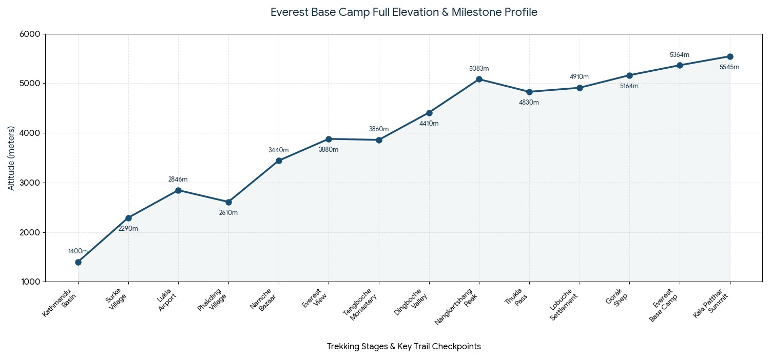
Trail Checkpoint
Elevation (M)| Elevation (ft)
Main Impact of Atmosphere
Kathmandu Basin
1,400 m | 4,593 ft
Baseline of your physical status at the sea-level.
Namche Bazaar Hub
3,440 m | 11,286 ft
The designated checkpoint of high-altitude zone.
Dingboche Valley
4,410 m | 14,468 ft
Significant decrease in oxygen levels, causes definite breathlessness.
Everest Base Camp
5,364 m | 17,598 ft
About 50% of the air-density of the sea-level oxygen composition.
Kala Patthar Peak
5,545 m | 18,192 ft
The maximum height you are going to gain on this trek.
The Primary Elevations on the Original EBC Trek :
Variations at the Starting Point: Altitude in Lukla or Driving via Surke
Like all classic Everest treks start at some point, even contemporary trekkers, with the advanced modern infrastructure now present, have an option to decide from where their journey to high alpine would begin. While on one hand flying brings a quick and direct jump, on the other hand the alternative of driving provides a smooth and low-elevation trek.
OPTION B: OVERLAND DRIVE TO > [Surke Village: 2,290m] > Gradual, Low-Impact Valley Approach
Comparisons on Differences on Starting Point :
Flight shock: Flying straight away will take you to Lukla airport elevation of 2,846 m (~9,337 ft) so the shock it imposes is about 1,446m.
Overland benefit: But if you choose the overland to Everest route, your hike starts in the village of Surke at 2,290 m (~7,513 ft), which gives a great buffer to your lungs from immediate spike in altitude.
Acclimatization advantage: Comparing the Lukla vs Surke altitude, going by Surke saves you with 556 m which means your body will be at ease with its self regulation of making red blood cells in the span of one day.
Weather certainty: Above all, since the Tenzing-Hillary Airport at Lukla is notoriously dependent on the flight schedule during weather turbulence, you completely take away the risk of flying back to Kathmandu again due to high-altitude induced stress caused by flight cancellations.
Logistics Metrics
Flying route to Lukla
Overland route via Surke | Physiological gain
Starting elevation
2,846 m (~9,337 ft)
2,290 m (~7,513 ft) | 556m difference makes a smoother and more safe start.
Air density on the first day
72% of sea-level
78% of sea-level | Your lungs are sure to welcome the more dense air with more oxygen at Surke.
Immediate Trail dynamics
Direct descent to Phakding
Gradual climb up to valley | The wake up with a proper cardiovascular exercise at the Surke route seems better for your body than the lungs.
Weather dependence
Highly dependent
No weather dependence | This is where you make your trek plan and follow it without doubt and uncertainty.
Comparison Chart of the Starting Metrics :
Rule of thumb for acclimatization: No matter which of these two options you choose; the golden rule that always has to be adhered to is that you always have to climb high during the day and sleep low during the night so that your body always has the chance to get adjusted to the reduced atmospheric pressure when you're high up, and it fully recovers its stamina while resting at the low altitude when you're down again.
All-inclusive package: Take away the stresses of deciding how and when to move from one place to another and planning it according to the acclimatization dynamics. Book your guided Everest Base Camp trek with Haven Holidays Pvt. Ltd. And the skilled local guides of the company are all ready to take care of all the tricky logistics so that you only focus on enjoying the amazing panorama. Contact us to craft your dream adventure to Everest Base Camp today!
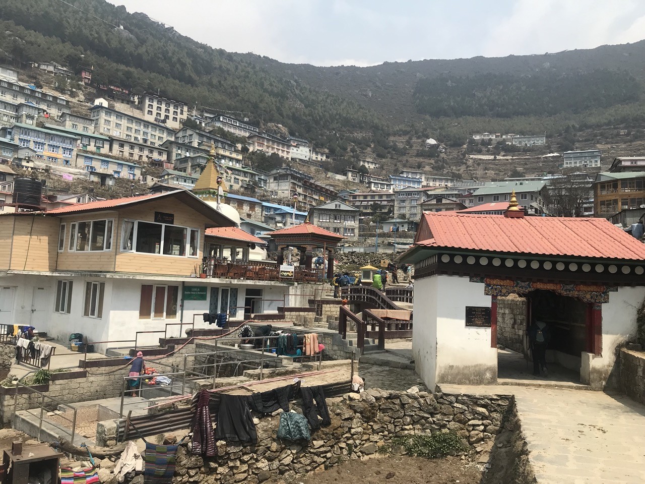
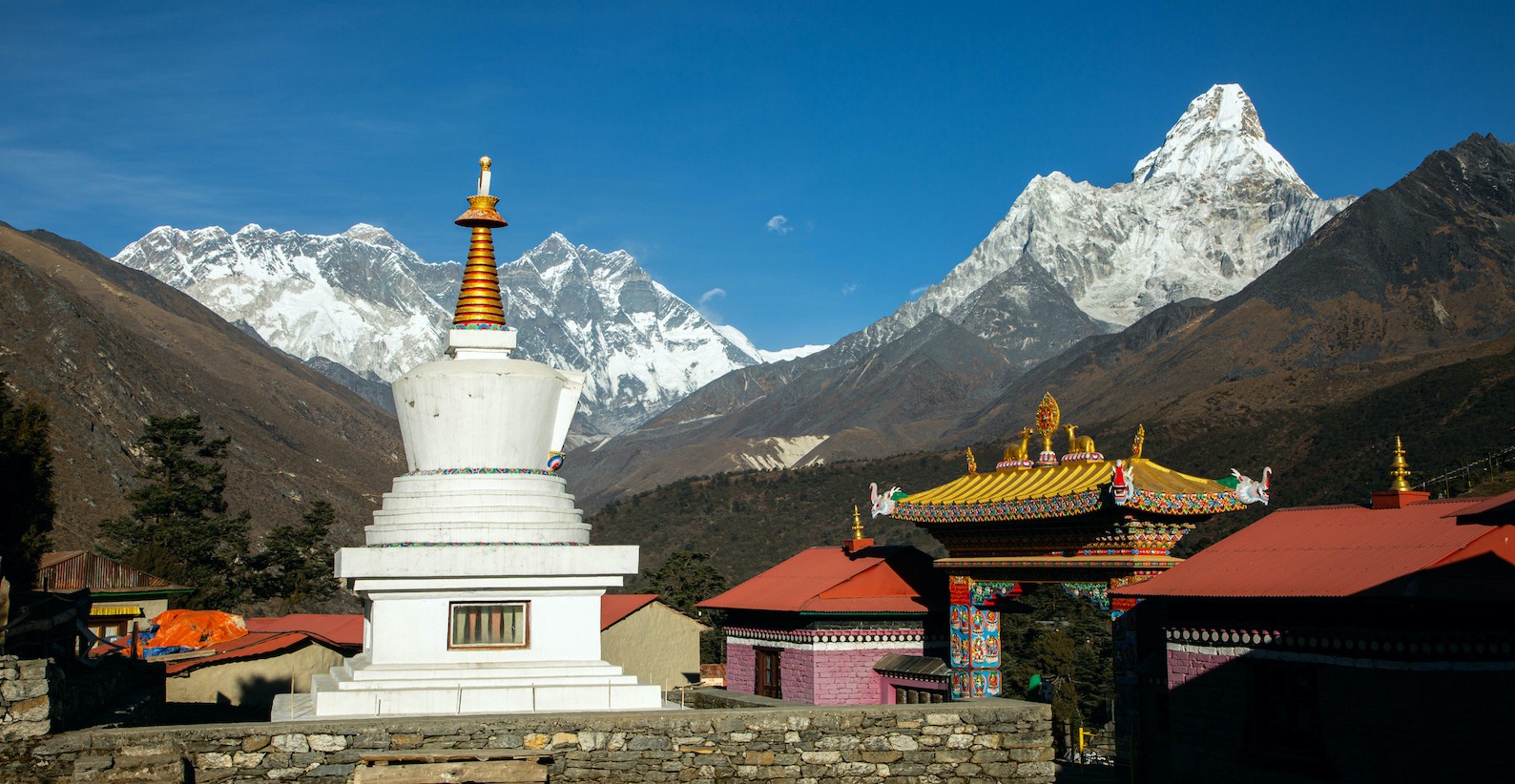
The First Upwards Journey: From Dudh Kosi River to Namche Bazaar
While the first day of your Everest Base Camp trek allows you a relatively easy, downward-going journey beside the rushing Dudh Koshi river, the second day will be the first day you truly feel the challenge of climbing a mountain. That climb is from a low of 2,610 m (~8,562 feet, the altitude of Phakding) to the stunning crescent-shaped market town of Namche Bazaar.
Namche Bazaar – the lively heart of the Everest region, blending culture, adventure, and stunning Himalayan scenery
Likewise, for first-time trekkers, this particular segment of the hike is widely known as the steepest climb on the EBC trek as you climb up a sheer wall over the course of one afternoon. The Challenges of Climbing to Namche Bazaar :
The Immense Vertical Gain: Climbing a grueling 830 meters (~2,724 feet) up to an altitude of 3,440 m (~11,286 feet) at Namche Bazaar in just under six hours will immediately impact your lungs as the air becomes significantly less dense.
The Treacherous High Larja Bridge: Before beginning your ascent, you must cross a dizzyingly high, double-tiered bridge over the river at Larja.
The Punishing Switchbacks in Pine Forests: After crossing the river, you begin climbing up a seemingly endless series of narrow, rock-strewn switchbacks winding through the dense, cooler pine forests.
The First Peek of Everest: About halfway through the agonizing uphill climb, a small, designated resting point will present you with your very first glimpse of Mount Everest rising above the trees.
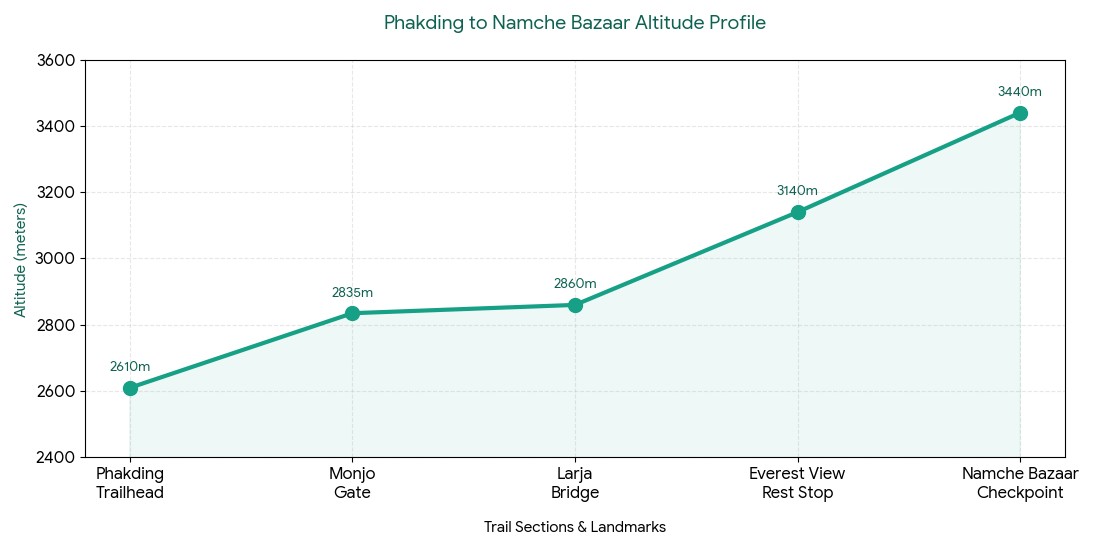
Trail Section / Landmark
Altitude (m) | Altitude (ft)
Health & Trail Notes
Phakding Trailhead
2,610 m | 8,562 ft
Breathable altitude; warm-up your muscles.
Monjo National Park Gate
2,835 m | 9,301 ft
Permit check point; remember to hydrate before the bridge.
Larja High Bridge
2,860 m | 9,383 ft
Your final lower altitude stop before the giant wall.
Everest View Resting Point
3,140 m | 10,301 ft
Stop to catch your breath and view the distant peaks.
Namche Bazaar Checkpoint
3,440 m | 11,286 ft
officially entering the high altitude zone.
Phakding to Namche Bazaar Altitude Profile :
Everest Base Camp Trek with Helicopter Fly Out 10 Days | 10 days
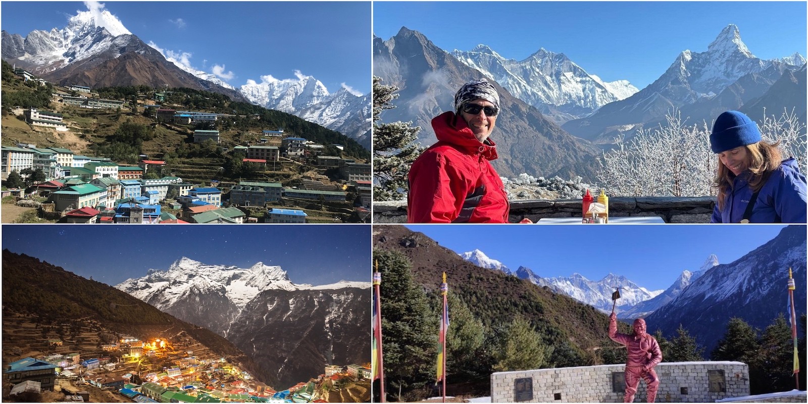
The Sacred Rule of Acclimatization: Why Namche Bazaar's Rest Day is Crucial
Actually, your body cannot instantly adjust to the lower levels of oxygen at over 3,000 m; charging straight through Namche Bazaar to a higher destination is a recipe for physical disaster. As such, a mandatory Namche Bazaar acclimatization day is not negotiable for beginners. This is the time that your body will secretly boost its oxygen-carrying capabilities by producing more red blood cells, making you that much stronger for the higher altitudes that lie ahead.
Acclimatization day in Namche Bazaar – a perfect moment to explore, adjust, and capture memories with fellow trekkers in the heart of the Everest region.
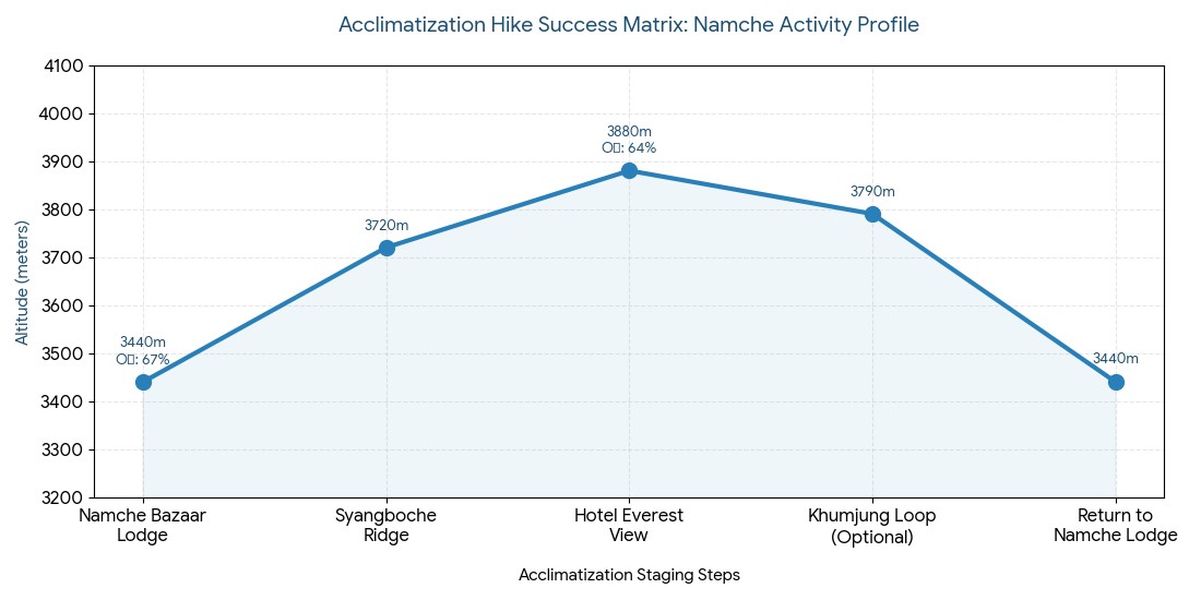
The Golden Strategy for Acclimatization :
The Basic Principle of Acclimatization: Instead of just staying in bed and dozing, you will actively put the hike high sleep low strategy to work by gaining altitude during the day, but sleeping at a lower elevation that night.
The Hike to Syangboche Ridge: At first, you will follow your guide up the steep staircase to the old, high-altitude airstrip at Syangboche, which stands at an altitude of 3,720 m (~12,204 feet).
Your Reward at the Everest View Hotel: You will continue onwards to your highest point of the day at 3,880 m (~12,730 feet) at the legendary Hotel Everest View. There you can rest and warm yourself with some hot lemon tea while marveling at the stunning vistas of Ama Dablam and Lhotse.
Rest and Recuperation in Namche: After one hour at nearly 3,900 meters to activate your system, you will trek back down the trail to Namche Bazaar at 3,440 m for the night.
Hike Destination
Altitude (m) | Altitude (ft)
How It Helps Your Body
Namche Bazaar Lodge
3,440 m | 11,286 ft
Base rest zone (67% sea level oxygen).
Syangboche Ridge
3,720 m | 12,204 ft
Initial workout to expand lungs (note: the trail gets very windy here!).
Hotel Everest View
3,880 m | 12,730 ft
Highest altitude of the day (64% oxygen); will boost red cell production.
Khumjung Village Loop (Optional)
3,790 m | 12,434 ft
Pleasant downhill cultural walk to visit the local monastery.
Return to Namche Lodge
3,440 m | 11,286 ft
Effective recovery sleep; heart rate should be nicely stabilized.
Acclimatization Hike Success Matrix :
The Rule of Mountain Life: It doesn't matter where you start your Everest Base Camp trek, there is only one fundamental rule you must remember, the "golden rule": hike high sleep low. By making your body work at high altitude and then recuperate at a lower level at night, your cardiorespiratory system is able to function far more efficiently in the rarefied atmosphere of the Himalayas.
The Stress-Free Experience with Haven Holidays Pvt. Ltd.: Planning an adventure trekking to Everest Base Camp of this magnitude involves the complexities of managing your itinerary effectively at altitude. When you book your trip to the Himalayas with Haven Holidays Pvt. Ltd., these concerns will be eliminated. Our guided treks are designed and executed by local Sherpas and knowledgeable guides who possess an intimate understanding of high-altitude logistics, allowing you to fully immerse yourself in the stunning landscapes without worry. Contact our team today to plan your tailor-made Everest Base Camp adventure!
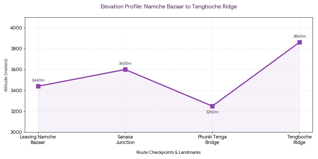
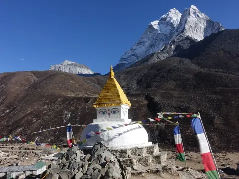
Ascending Further: The Namche to Tengboche Monastery Elevation Change
After successfully acclimating your body to the air pressure in the capital of the Sherpas, you will take another upward journey deep into the holy lands of the Khumbu-more precisely, the trail from Namche to Tengboche monastery involves a very dramatic undulating trajectory that begins on a very high, scenic walk far above the Dudh Koshi river, but soon dips steeply into the riverside village of Phunki Tenga (3,250 m / ~10,662 ft), from where you will need to recover everything, plus some, on an extremely tough climb up through lush pine and rhododendron forests
Tengboche – a spiritual Himalayan stop with breathtaking mountain views and peaceful monastery surroundings.
Landmarks of the Tengboche Ridge Ascent :
The Deep River Gorge: Since you will be walking all the way to the rushing river at Phunki Tenga and climbing back up after crossing the suspension bridge, you will get a short, oxygen-rich break before the arduous uphill trek.
The Spiritual Gateways: As you walk on zigzag paths with mani stones and small chortens, it will be clear that you are nearing sacred grounds-the lands of the monastery there.
The High-Altitude Settlement: At the end of the challenging ascent you will arrive at an official Tengboche elevation of 3,860 m (~12,664 ft), and since the air temperature will be much lower at such high altitudes you should change into your down jacket immediately.
The Majestic Himalayan Scenery: Further still, arriving at the Tengboche monastery altitude will open up to you the best and most beautiful panorama of Everest, Ama Dablam, and Lhotse directly beyond the monastery.
Route Checkpoint / Landmark
Altitude in Meters | Altitude in Feet
Trail dynamics and tips
Leaving Namche Bazaar
3,440 m | 11,286 ft
The trail is mostly a level walking section above a cliff; try to find a steady breathing rhythm.
Sanasa Junction
3,600 m | 11,811 ft
The route diverges toward Gokyo; the path continues to the right toward Everest Base Camp.
Phunki Tenga Bridge
3,250 m | 10,662 ft
the lowest elevation of the trek so far; ideal spot for lunch before starting the steep uphill climb.
Tengboche Ridge
3,860 m | 12,664 ft
High Alpine ridge; put your down jacket on as soon as you reach this point.
Elevation Profile: Namche Bazaar to Tengboche Ridge
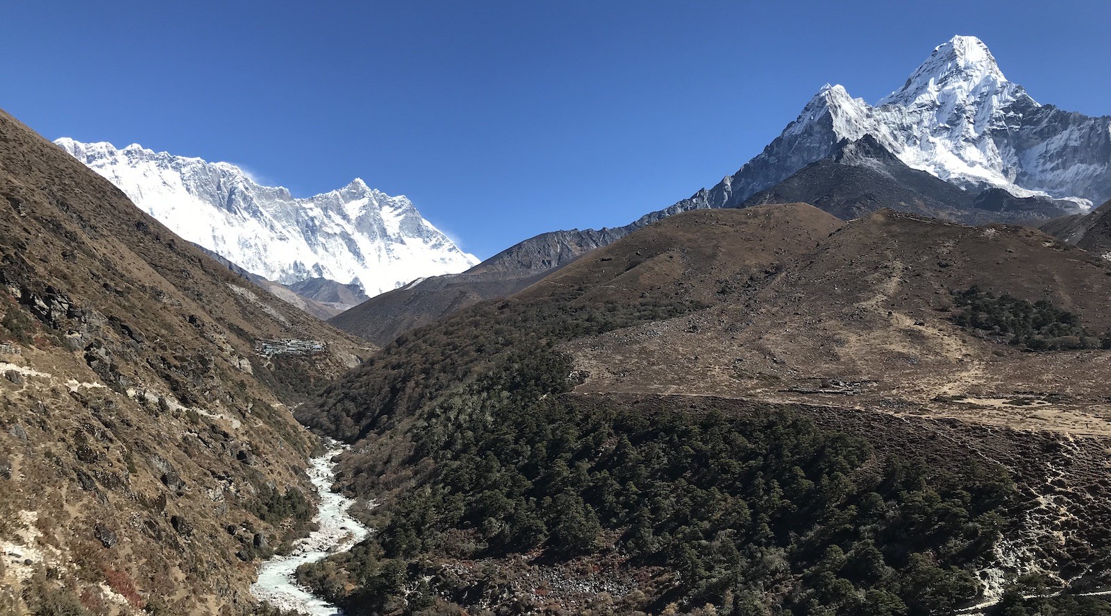
Crossing the 4000-meter mark: The Imja Valley and Dingboche Trail
Leaving the trees behind, you will experience a noticeable change in the surroundings the next morning and finally be crossing the 4,000-meter frontier as you tread along the Imja valley trail which clearly demarcates the limit of lush greenery fading away into a stark, wind-swept high-altitude alpine desert. Furthermore, since the elevation of your ultimate destination is 4,410 m (~14,468 ft in Dingboche), this part of the journey requires considerable psychological adjustment as you prepare for several consecutive days above 4000m with no trees in sight.
Heading to Dingboche – where rivers, alpine valleys, and majestic Himalayan peaks create an unforgettable trekking experience.
Environmental shifts at high altitude :
Pangboche safe haven: You will begin the journey passing by the stone houses of Pangboche village (3,930 m), the site of the oldest monastery in all of the Khumbu.
Alpine Scenery Development: Ama Dablam will eventually start taking shape at the top of your right shoulder as you make your way deeper into the valley, with scrub junipers thinning into rocks and dust.
Imja valley entry funnel: Eventually the river valley itself becomes a funnel guiding your steps into the spacious cold expanses of barley and potato fields.
Extreme low nighttime temperature: By the time you reach the stone tea house at Dingboche, absence of any protection from natural forest cover results in temperature that plummets below freezing at night due to the wind.
Trail Segment / Landmark
Meters | Feet
Effective oxygen and surroundings
Tengboche Exit
3,860 m | 12,664 ft
last stretch of forest cover before dropping down to cross river.
Pangboche Village
3,930 m | 12,893 ft
last permanently inhabited village along the EBC route.
Shomare stop point
4,010 m | 13,156 ft
official 4000m border crossed; you burn 30% more calories at this altitude.
Dingboche village
4,410 m | 14,468 ft
High mountain valley; 59% of sea level oxygen.
Elevation and oxygen changes to Dingboche :
The Expert Guide to Acclimatization: Whatever route you decide on according to your own travel style, the cardinal rule of safe mountaineering stays unchanged: Climb high, sleep low. By pushing your body to high altitudes during acclimatization walks, you stimulate it to acclimatize to low pressure of oxygen, whereas returning to a lower altitude at night allows it to recuperate and recover.
Your Comprehensive Experience: When you plan your trip to the Himalayas like Everest Base Camp Trek with Haven Holidays Pvt. Ltd. You no longer have to deal with such complex route considerations. All of our itineraries are created by our team of highly experienced Sherpa and local guides who account for the subtleties of high-altitude logistics to guarantee that the route is always clear and safe to travel, thus allowing you to simply take in the magnificent mountain views. Get in touch with our team now to book your dream trip to Everest!
The Crucial Second Acclimatization Hike-Summiting Nangkartshang Peak
Because the 4,000-meter marker has been crossed, the previous day's rest in Namche is no longer sufficient to safely proceed up the trail. Taking a full Dingboche acclimatization day is essential before embarking upon the stark frozen moraines of the upper Khumbu glacier. During this vital pause, trekkers will ascend a strenuous side summit with the sole purpose of pushing the respiratory system through severe thin-air and initiating an inevitable high altitude adaptation response.
Nangkartshang Peak acclimatization hike – stunning views over the Imja Valley with Everest region giants all around
Driving The Physiological Process :
A Vertical Ascent for Stature: To build structural endurance, you will embark on a rocky and incredibly steep ridge climb just out of the backside of the village toward the towering Nangkartshang peak altitude of 5,083m (16,676ft).
The EPO Production Stimulant: By sending your lungs to an altitude where the effective oxygen drops below 55% you will immediately jumpstart your kidneys to producing erythropoietin which ultimately creates a cascade of new red blood cells.
A Tactical Turnaround in The Mountains: Although standing on top of the prayer-flag-adorned ridge will be a significant milestone in and of itself, there is no need to reach the absolute highest point as your goal should only be to reach approximately 4,800-5,000 meters.
Deep Recovery in The Lowlands: after a brief hour at high altitude which sends your body through a shock mode, you will immediately turn around and return to the Dingboche altitude of 4,410m (14,468ft) where you will eat a hot meal and recover soundly.
High Alpine Target Point
Target Elevation(m) |Target Elevation(ft)
Connective Oxygen & Pacing Strategy
Dingboche Valley floor
4,410 m | 14,468 ft
Base altitude where you will sleep tonight, remember to drink 4 liters of water!
Lower Ridge Viewpoint
4,650 m | 15,255 ft
First sight of Pheriche valley, strong wind gusts will begin here
Mid-Mountain Plateau
4,850 m | 15,912 ft
Critical zone for high altitude lung expansion; pause for 20 minutes.
Nangkartshang Summit
5,083 m | 16,676 ft
Maximum day elevation; check out Makalu before the downward journey.
Venturing to the High Glacier Edge-Pushing the Trail toward Lobuche
Here, your successful transition to the Dingboche valley altitude will allow you to march directly to the stark world high above the glacier. The path ahead is a wide and gradually increasing plain before spilling down into the river-town of Dughla (Thukla). It's the stretch just past the river crossing, however, where you will have to ascend the punishing and steep wall to the Thukla pass altitude of 4,830m (15,846ft)-an altitude that will simultaneously take your breath away and your mind on a reflective journey.
From Dingboche to Lobuche – a dramatic alpine valley journey through glaciers, mountains, and high-altitude wilderness.
Navigating The High Glacial Moraine :
The Brutal Staircase to The Pass: because of the exceptionally steep trail and loose scree rock that accompanies the ascent, you will have to move at a snail’s pace with calculated strides-try to treat the ascent as though you're on robotic legs.
The Climber Memorial Sanctuary: you will ascend into the breathtaking world of hundreds of carefully stacked stones-all monuments to fallen climbers and Sherpas on Everest; pause at the top and remember why you're traveling here.
The Lateral Khumbu Glacier Trail: you will begin trekking the vast glacial moraine which sprawls for many miles along the side of the glacier; look out for incredible piles of rock from thousands of years past.
The Final March to High Elevation: after a long, steady march with incredible views of Everest, you will reach the official Lobuche altitude of 4,910m (16,108ft).
Geographical Milestone
Precise Elevation(m) | Precise Elevation(ft)
Connective Terrain Challenges & Advice
Dingboche Outflow
4,410 m | 14,468 ft
Easy and open path along the valley; use trekking poles for balance.
Thukla Snack Stop
4,620 m | 15,157 ft
This is where the climb up the moraine begins; fuel with carbs.
Thukla Pass Crest
4,830 m | 15,846 ft
The Memorial Zone; be sure to say some words in remembrance and allow your breathing to normalize.
Lobuche Settlement
4,910 m | 16,108 ft
You will feel the severe cold here immediately; pull out your merino base layers for immediate use.
Elevation and Logistics Profile: Dingboche to Lobuche
The Expert Acclimatization Golden Rule: regardless of which starting variations suit your travel style, the golden rule for trekking in the mountains cannot be stressed enough: climb high and sleep low. By taking a rigorous acclimatization hike that sends you to higher elevations during the day your body will naturally acclimatize to thinner air but by returning to lower elevations where your body will repair itself you will build the stamina needed for each successive day in the Khumbu.
The Advantage of Pre-Planned Treks: When traveling with Haven Holidays Pvt. Ltd. You need not worry about the logistics of high altitude travel, as each expedition is guided by seasoned local experts. They create a safe, comfortable trekking experience, while allowing you to completely enjoy your trek; contact us today to plan your Himalayan adventure!
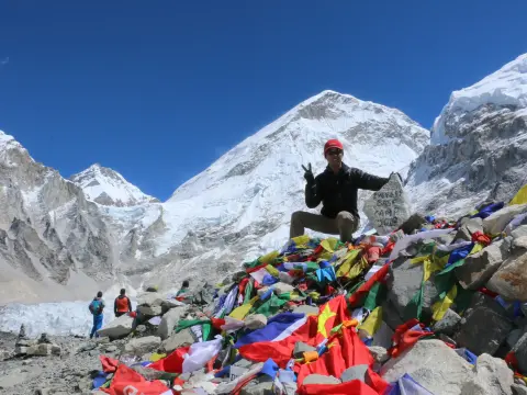
Arriving at the Summit: Gorak Shep and Everest Base Camp Altitudes
Everest Base Camp – standing at the iconic rock after an unforgettable journey through the Himalayas.
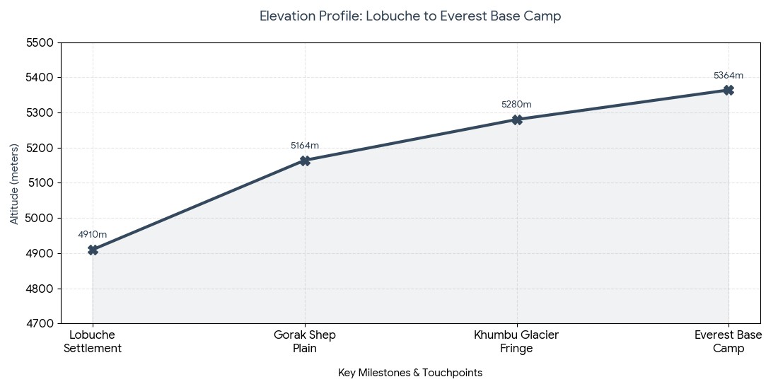
Here, your multi-day adventure trek will reach its climatic peak during an extremely arduous and physically taxing trek across the western edge of the Khumbu Glacier, culminating in Gorak Shep and ultimately Everest Base Camp itself. The section from Lobuche will involve trekking over a broken, rock-laden pathway winding along the side of a moraine, and due to the constant, rapid ups and downs over glacial debris and scree, it's widely regarded as one of the most challenging stretches of the entire trek. For that reason, reaching the barren final settlement of Gorak Shep is as much an emotional high as anything else, but it’s just the starting point for your real destination. The final trek across the Khumbu moraine :
The Highest Stop: Upon reaching Gorak Shep at 5,164 m (16,942 ft), it’s the highest transient settlement on the normal EBC trek.
Glacial spine crossing: After leaving your gear at the lodge, it’s time to embark on the notoriously difficult, three-hour return trip trek up the rugged, active glacier’s perimeter toward Base Camp.
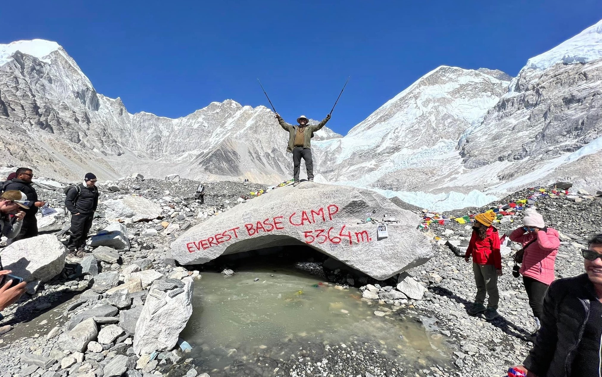
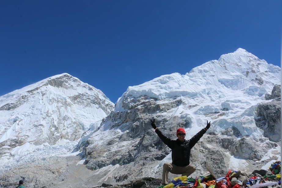
Base Camp entrance: Trekcing across ice-bitten rocky terrain, you'll reach the actual altitude of Everest Base Camp at 5,364 m (17,598 ft).
Expedition center: During the spring season, you can walk right through the world’s highest tent city where scores of international expeditions erect hundreds of brilliant yellow tents directly on the ice.
Landmark/Point
Elevation (m) | Elevation (ft)
Physiological significance & Status
Lobuche Settlement
4,910 m | 16,108 ft
Cold alpine conditions; oxygen density about 53% of sea level.
Gorak Shep Plain
5,164 m | 16,942 ft
Formerly a frozen lakebed; last opportunity to hydrate before Base Camp.
Khumbu Glacier Fringe
5,280 m | 17,322 ft
Unstable ground; be alert for falling rocks and ice.
Everest Base Camp
5,364 m | 17,598 ft
Your Destination; oxygen density 50% of sea level.
Elevation profile: Lobuche to Everest Base Camp
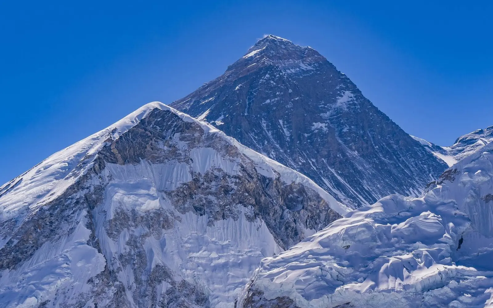
The Apex Altitude: Kala Patthar summit
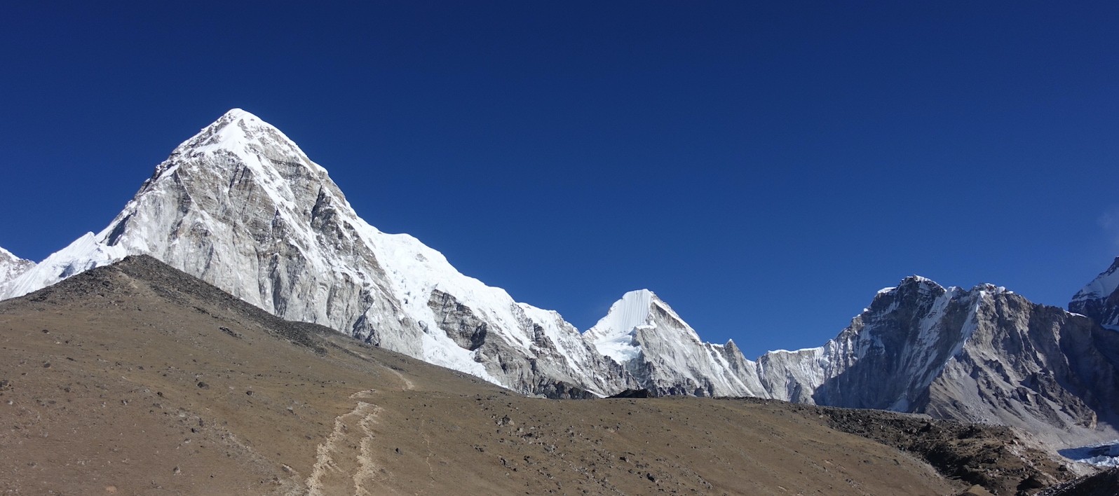
While Everest Base Camp is the main attraction, the camp is nestled within a basin making Everest’s peak entirely hidden behind the imposing bulk of Mount Nuptse. To catch a glimpse of the iconic vista, you'll have to push yourself that much further to climb the steep, black volcanic ridge directly behind Gorak Shep, ideally pre-dawn.
On the way to Kala Patthar – dramatic Himalayan trails, crisp mountain air, and stunning views of Pumori and Everest region giants.
Climbing the highest point of your trek :
The Summit Point: Ascending this windswept ridge will bring you to the Kala Patthar summit at 5,545 m (18,192 ft), the absolute highest point on the EBC trek. Slow pace up: As the oxygen density is less than half of what it is at sea level, you’ll have to take extremely slow, measured steps all the way up to the summit to avoid dizzy spells. Sunrise spectacle: Upon reaching the peak as the sun begins to rise, it’s rewardingly spectacular as it bathes Mount Everest in golden hues during an unbelievable sunrise over the mountain. Khumbu panoramic view: From this vantage point, you’ll have the chance to see the entire geographical profile of the Khumbu Icefall, the massive summit of Lhotse, and Everest’s stark, wind-blasted southwest face.
Viewpoint on Kala Patthar
Elevation (m) | Elevation (ft)
Oxygen Levels and Tips
Gorak Shep Start Point
5,164 m | 16,942 ft
Departure before dawn; temperatures can drop as low as -15 C.
Midway Ridge plateau
5,350 m | 17,552 ft
Strong winds; keep your extremities warm, and your breathing steady.
Intermediate Viewpoint
5,460 m | 17,913 ft
Enjoy the view of Mount Pumori on your left and maintain rhythmic breathing.
Kala Patthar Summit
5,545 m | 18,192 ft
Do not exceed 20 minutes to prevent hypothermia; you have reached the highest point!
Elevation breakdown: Ascent to Kala Patthar
The Law of Acclimatization: No matter which option suits you best, the overarching principle when hiking high mountains is "Climb high, sleep low." By taking hikes to higher elevations throughout your afternoon, you can give your body time to adjust to the lower pressure at higher altitudes, while descending back to sleep at a lower elevation allows your body to rest and recover properly before the next day.
All-Included trekking: With Haven Holidays Pvt. Ltd., planning your trek is easy. Our seasoned guides plan out everything based on the volatile logistics of high-altitude trekking, ensuring that the trip proceeds smoothly and without incident so you can focus solely on the magnificent landscapes of the Himalayas. Contact us today to customize your dream trek to Everest!
Island Peak Climb with Everest Base Camp Trek | 21 days
Altitude Sickness: How to Avoid AMS, Its Symptoms, and Safety Protocols
Above 3,000 meters (9,842 feet), your body’s physiological response to the thinning atmosphere becomes a critical issue, essentially a matter of survival. The most important skill any trekker needs to bring to the trail is recognizing the initial altitude sickness symptoms EBC in themselves and their fellow trekkers, because AMS can affect anyone regardless of fitness level.
Here, ignoring the minor warning signals can rapidly lead to a life-threatening condition like HAPE (High Altitude Pulmonary Edema) or HACE (High Altitude Cerebral Edema), making strict adherence to the safety protocols a mandatory practice for everyone on the team.
Initial Symptoms and Advanced Warning Signs :
Mild AMS: As the air pressure changes, you may experience a mild throbbing headache, dizziness, reduced appetite, sleeplessness, or slight nausea following strenuous climbing.
Critical Signs of HAPE/HACE: Persistent, wet cough; severe shortness of breath even while resting; slurred speech; complete loss of coordination can be an immediate red flag that this is a medical emergency.
The No-Go-Higher Directive: You should never sleep at an elevation higher than where you currently feel symptoms. Either stay where you are or immediately descend to a lower altitude.
The Hydration imperative: Due to the rapid loss of fluid through your breath in the dry, alpine air, you must consume at least 4 liters of clean water daily to assist your kidneys in maintaining your blood pH balance.
Standard Medical Interventions :
Prophylactic Measures: When planning your trek, it is highly recommended to discuss the typical diamox dosage Nepal trekking recommendations with a travel physician. Experts generally: Recommend a prophylactic dose of 125-250mg of Acetazolamide (Diamox) taken twice daily, beginning either in Kathmandu or Lukla.
Diamox’s Role: This mild diuretic helps your kidneys expel bicarbonate from your blood, making your blood more acidic. This in turn triggers deeper and faster breathing, which helps your body acclimatize more quickly.
Emergency Helicopter Evacuation: Should your physical condition continue to deteriorate even after resting and descending, the team leader will initiate an emergency helicopter evacuation without delay.
Evacuation Procedures: Due to the rapid changes in alpine weather, these private helicopters can be dispatched from Kathmandu or Lukla and will fly critical patients to medical facilities in the capital before the altitude causes permanent damage.
Severity Level
Observable Physical Symptoms
Immediate Trail Action Required | Medical / Pharmaceutical Protocol
Mild AMS
Headache, fatigue, light dizziness, loss of appetite
Halt all upward progress; rest at current teahouse for 24 hours. | Increase hydration (4-5L); consider Diamox (125mg doses).
Immediate emergency evacuation to a lower altitude | High-flow oxygen, dexamethasone/nifedipine (if available); call for rescue chopper.
AMS Medical Safety Framework :
Conclusion: A Comprehensive Overview of Everest Base Camp's Elevation Changes
Understanding and mastering the vertical dynamics of the Khumbu region is the ultimate key to transforming your potentially perilous expedition into a triumphant alpine adventure. Whether you embark on a fast-paced journey via the typical flight or a more leisurely EBC overland route, your success will be entirely determined by your unwavering commitment to ascending slowly and deliberately. By choosing a thoughtful Everest Base Camp itinerary planning guide that respects your body’s biological limitations, you will ensure that your memories of Base Camp are filled with awe and triumph rather than pain and discomfort.
Crafting Your Perfect Vertical Journey :
Comparing Routes: When evaluating your EBC trek altitude breakdown, keep in mind that the overland route from Surke offers two to three extra days of low-altitude trekking, which provides an excellent physiological preparation for the challenging ascent to Namche Bazaar.
The Retention Principle: It is wise to save or screenshot a summary of the elevations, so you can easily compare your daily vertical gain to your pulse oximeter readings. Professional Guidance: Ultimately, successfully managing these vast vertical shifts relies on the watchful eyes of experienced guides who can monitor subtle changes in your breathing, heart rate, and energy levels.
5,364 | 17,598 | The Ultimate Goal; celebration on the glacier.
The Maximum Peak
Kala Patthar Summit
5,545 | 18,192 | Highest point of the trek; panoramic views.
Everest Base Camp Elevation and Milestone Quick Reference :
The Expert Acclimatization Rule: Regardless of your chosen starting route, always remember the cardinal rule of mountain safety: Climb high, sleep low. Your afternoon acclimatization hikes to a higher elevation prompt your body to adjust to lower oxygen levels, while sleeping at a lower altitude allows for optimal recovery and building stamina for the days ahead.
FAQs- Everest Base Camp trek Altitude Variations
1. What is the beginning elevation on the Everest Base Camp trek? The classic Everest Base Camp trek altitude profile starts from Lukla airport, an elevation of 2,860 meters (9,383 feet). From Lukla the trail begins to descend steeply to Phakding at 2,610 meters to give trekkers an easier introductory phase to the Khumbu region.
2. What is the maximum Everest Base Camp trek altitude? The peak altitude on a standard Everest Base Camp trek itinerary is the summit of Kala Patthar at an altitude of 5,550 meters (18,208 feet). The Everest Base Camp viewpoint is slightly lower at 5,364 meters, but Kala Patthar is always chosen as the preferred viewpoint for sunrise due to unobstructed views of Mount Everest.
3. How intense is the altitude variation from Namche Bazaar climb? The Everest Base Camp trek altitude profile and vertical gradient between Jorsalle (2,740m) and Namche Bazaar (3,440m) causes a huge vertical ascent and is perhaps the first strenuous rise in altitude. You ascend 700 meters up the dusty Khumbu terrain from the riverbed to the village of Namche.
4. Why are rest days essential on Everest Base Camp treks? An appropriate Everest Base Camp trek itinerary schedules mandatory rest days at Namche Bazaar (3,440m) and Dingboche (4,410m) where trekkers may ascend only 300-500 meters during the day and descend at night. These vertical variations give your body essential time to make more red blood cells and avoid Acute Mountain Sickness.
5. What is the elevation of Tengboche Monastery during an EBC trek? Tengboche Monastery stands at 3,860 meters (12,664 feet) above sea level. The Everest Base Camp trek altitude profile and its elevations during this section include a dramatic drop down into the Imja Khola valley, followed by a sustained and grueling 600 meter climb up to the monastery through thick rhododendron forests on the ridges.
6. Does the altitude profile flatten after Dingboche? No, the Everest Base Camp trek altitude profile changes to a noticeably steadier upward incline after Dingboche (4,410m). You will continue to climb to Lobuche (4,910m) and then to Gorak Shep (5,140m) over moraine and the Thukla Pass to eventually arrive at your trek destination, but as you leave the treeline, the climb becomes significantly steeper at every turn.
7. What is the altitude profile for reaching Everest Base Camp? From the high-altitude glacial lakebed at Gorak Shep (5,140m), you will hike across lateral moraine, loose scree, and undulating glaciers for approximately 3.5 kilometers until you reach Everest Base Camp at 5,364 meters, before hiking back up to sleep in Gorak Shep.
8. What is the change in oxygen levels on an EBC trek? Oxygen levels decrease with altitude; at sea level you are exposed to 100% oxygen concentration, at Namche Bazaar (3,440m) it will be approximately 67%, and by the time you reach Everest Base Camp (5,364m) you will be exposed to just 50% oxygen.
9. Can altering the Everest Base Camp trek itinerary avoid altitude sickness? While no journey completely eliminates altitude sickness risks, a slow and methodical Everest Base Camp trek itinerary that prioritizes climbing no more than 500 vertical meters a day over 3,000 meters is essential to let your body adapt to the sharp changes in altitude.
10. What is the elevation gain from Lobuche to Gorak Shep? The final push from Lobuche (4,910m) to Gorak Shep (5,140m) consists of an additional 230 meters of altitude gain. However, before reaching Lobuche, trekkers are confronted by a steep ascent through the infamous Thukla Pass, contributing greatly to the difficulty of the day.
11. Is Gorak Shep the highest lodging point on the Everest Base Camp trek? Yes, with a startling altitude of 5,140 meters (16,863 feet), Gorak Shep offers the highest altitude sleeping arrangements on the Everest Base Camp trek. However, the elevation can disturb your sleep, so proper hydration remains crucial.
12. How much is high altitude travel insurance for EBC? Standard travel insurance policies will not cover incidents related to the extreme elevations involved in an Everest Base Camp trek; you will need specialist high altitude insurance for medical helicopter evacuations up to 6,000 meters, costing approximately $150 to $250 USD in addition to your other trekking expenses.
13. What does the altitude profile look like when descending on an EBC trek? The return leg of the Everest Base Camp trek altitude profile will feature a steep descent in elevation from Gorak Shep (5,140m) all the way down to Pheriche (4,240m) or Pangboche (3,980m). This will result in a welcome increase in your oxygen levels.
14. What are the symptoms of altitude sickness when trekking? Failing to adjust to the severe altitudes experienced throughout the Everest Base Camp trek altitude profile will lead to Acute Mountain Sickness. Initial symptoms include loss of appetite, nausea, a throbbing headache, and lightheadedness. The only effective treatment is immediate descent to lower altitudes.
15. What is "climb high sleep low" on the EBC trek? This core practice of acclimatization during an Everest Base Camp trek itinerary is to deliberately ascend to a higher altitude than where you will sleep, then return. For example, trekking up to the Everest View hotel (3,880m) while sleeping in Namche Bazaar (3,440m).
16. How does altitude variation affect EBC trek difficulty? The Everest Base Camp trek altitude profile and its severe elevation changes are by far the main cause of its reputation as a difficult hike; hiking 130 kilometers is not challenging enough in itself, but hiking the distance over an altitude variation that climbs to 5,550 meters will challenge anyone's cardio.
17. Are there altitude sickness treatment facilities along the Everest Base Camp trek route? Yes, there are well established altitude sickness clinics at Pheriche (4,240m) where highly specialized international doctors offer treatment. There is also a rescue station in Manjo, the only facility at a relatively lower elevation which can treat acute sickness.
18. Does drinking water help combat the EBC trek altitude profile? Drinking a large amount of purified water is vital to overcoming the challenges of the Everest Base Camp trek altitude profile. Losing so much moisture at such high elevations may dry you out rapidly, affecting the volume of your blood, and potentially giving you headaches, so drinking four to five liters of water daily is absolutely necessary.
19. Is it possible to avoid the Everest Base Camp trek altitude profile using a helicopter tour? For those who wish to view Mount Everest but are apprehensive about the challenging Everest Base Camp trek difficulty, there are alternative Everest helicopter tours which fly you directly from Kathmandu and provide incredible panoramic views of Everest and surrounding Himalayan peaks while also offering landing on the famous Kala Patthar.