[{"name":"Everest Base Camp Helicopter Tour","duration":"1","image_url":"https:\/\/www.havenholidaysnepal.com\/storage\/trip-galleries\/1\/thumb_6cd53005d75a86e373d31419d1b14d78.webp","offer_price":1195,"url":"https:\/\/www.havenholidaysnepal.com\/trips\/everest-base-camp-helicopter-tour"},{"name":"Everest Mountain Flight","duration":"1","image_url":"https:\/\/www.havenholidaysnepal.com\/storage\/trip-galleries\/4\/thumb_3b0b4f1d6f72b0ad224daf4752f2c6e0.jpg","offer_price":285,"url":"https:\/\/www.havenholidaysnepal.com\/trips\/everest-mountain-flight"},{"name":"Everest Short Trek","duration":"9","image_url":"https:\/\/www.havenholidaysnepal.com\/storage\/trip-galleries\/5\/thumb_BXPP3621.JPEG0.02033800 1727957098.webp","offer_price":995,"url":"https:\/\/www.havenholidaysnepal.com\/trips\/everest-short-trek"},{"name":"Gokyo Valley Trek","duration":"12","image_url":"https:\/\/www.havenholidaysnepal.com\/storage\/trip-galleries\/6\/thumb_10bc469b14731f23d3ce84a7092ad53f.jpg","offer_price":1195,"url":"https:\/\/www.havenholidaysnepal.com\/trips\/gokyo-valley-trek"},{"name":"15 days Annapurna Base Camp Trek","duration":"15","image_url":"https:\/\/www.havenholidaysnepal.com\/storage\/trip-galleries\/7\/thumb_87d1533bc45faf070990aef0579e4be4.jpg0.81855100 1728285496.webp","offer_price":785,"url":"https:\/\/www.havenholidaysnepal.com\/trips\/15-days-annapurna-base-camp-trek"},{"name":"Nepal Pilgrimage Tour","duration":"14","image_url":"https:\/\/www.havenholidaysnepal.com\/storage\/trip-galleries\/8\/thumb_02c3bcf2ad2e8a4c1703e90ae747b5f1.jpg","offer_price":1475,"url":"https:\/\/www.havenholidaysnepal.com\/trips\/nepal-pilgrimage-tour"},{"name":"UNESCO World Heritage Site Tour","duration":"10","image_url":"https:\/\/www.havenholidaysnepal.com\/storage\/trip-galleries\/9\/thumb_unesco-world-heritage-site-Lumbani-temple-buddhists-hindus-kathmandu-nepal0.36988600 17347617740.93089500 1737469667.webp","offer_price":715,"url":"https:\/\/www.havenholidaysnepal.com\/trips\/unesco-world-heritage-site-tour"},{"name":"Island Peak Climbing","duration":"16","image_url":"https:\/\/www.havenholidaysnepal.com\/storage\/trip-galleries\/11\/thumb_Island peak0.53947000 1734692503.webp","offer_price":2495,"url":"https:\/\/www.havenholidaysnepal.com\/trips\/island-peak-climbing"},{"name":"Upper Mustang Trek","duration":"18","image_url":"https:\/\/www.havenholidaysnepal.com\/storage\/trip-galleries\/12\/thumb_upper mustang 7 Oct-2024.jpg0.95398900 1728286166.webp","offer_price":2995,"url":"https:\/\/www.havenholidaysnepal.com\/trips\/upper-mustang-trek"},{"name":"Annapurna Circuit Trek","duration":"16","image_url":"https:\/\/www.havenholidaysnepal.com\/storage\/trip-galleries\/15\/thumb_tibetan-flags.jpg0.04843900 1728289138.webp","offer_price":985,"url":"https:\/\/www.havenholidaysnepal.com\/trips\/annapurna-circuit-trek"},{"name":"Gosainkunda Lake Trek","duration":"10","image_url":"https:\/\/www.havenholidaysnepal.com\/storage\/trip-galleries\/16\/thumb_5A8083B3-C007-41A8-853F-D0C37C97D235_1_105_c.jpeg0.52581200 1731845258.webp","offer_price":595,"url":"https:\/\/www.havenholidaysnepal.com\/trips\/gosainkunda-lake-trek"},{"name":"Zip-lining in Pokhara and Dhulikhel","duration":"1","image_url":"https:\/\/www.havenholidaysnepal.com\/storage\/trip-galleries\/18\/thumb_215f765e2ebc995dd5c800b4bfdbacc3.jpg","offer_price":82,"url":"https:\/\/www.havenholidaysnepal.com\/trips\/zip-lining-in-pokhara-and-dhulikhel"},{"name":"Annapurna Heli Tour","duration":"1","image_url":"https:\/\/www.havenholidaysnepal.com\/storage\/trip-galleries\/19\/thumb_d71a6bbb9fd4da8d1b567a5cdbdec85d.jpg","offer_price":555,"url":"https:\/\/www.havenholidaysnepal.com\/trips\/annapurna-heli-tour"},{"name":"Paragliding in Pokhara","duration":"1","image_url":"https:\/\/www.havenholidaysnepal.com\/storage\/trip-galleries\/20\/thumb_de788d2dd9726783431f882c007efae1.jpg","offer_price":65,"url":"https:\/\/www.havenholidaysnepal.com\/trips\/paragliding-in-pokhara"},{"name":"Ultra-Flight in Pokhara","duration":"1","image_url":"https:\/\/www.havenholidaysnepal.com\/storage\/trip-galleries\/21\/thumb_e27a9fb572a5c21611bb2a3c18e4b8f0.jpeg","offer_price":175,"url":"https:\/\/www.havenholidaysnepal.com\/trips\/ultra-flight-in-pokhara"},{"name":"Sarangkot Hiking","duration":"1","image_url":"https:\/\/www.havenholidaysnepal.com\/storage\/trip-galleries\/22\/thumb_100ef822fea19987166c6c1366215f15.jpg","offer_price":55,"url":"https:\/\/www.havenholidaysnepal.com\/trips\/sarangkot-hiking"},{"name":"Mera Peak Climbing","duration":"18","image_url":"https:\/\/www.havenholidaysnepal.com\/storage\/trip-galleries\/24\/thumb_d16ae3895f678cf26ffbf2455f541fb5.jpg0.31883400 1732617790.webp","offer_price":2475,"url":"https:\/\/www.havenholidaysnepal.com\/trips\/mera-peak-climbing"},{"name":"Lower Dolpo Trek","duration":"18","image_url":"https:\/\/www.havenholidaysnepal.com\/storage\/trip-galleries\/26\/thumb_Dolpo Galary - 1.JPG0.37725200 1727939952.webp","offer_price":2995,"url":"https:\/\/www.havenholidaysnepal.com\/trips\/lower-dolpo-trek"},{"name":"Nagarkot Sunrise\/Sunset Tour","duration":"1","image_url":"https:\/\/www.havenholidaysnepal.com\/storage\/trip-galleries\/27\/thumb_5147a5532644283a380f2e86f3857c13.jpg0.17748000 1728488108.webp","offer_price":30,"url":"https:\/\/www.havenholidaysnepal.com\/trips\/nagarkot-sunrise-sunset-tour"},{"name":"16 day Everest Base Camp Trek","duration":"16","image_url":"https:\/\/www.havenholidaysnepal.com\/storage\/trip-galleries\/28\/thumb_IMG_4311.JPG0.64984800 1727942213.webp","offer_price":1475,"url":"https:\/\/www.havenholidaysnepal.com\/trips\/16-day-everest-base-camp-trek"},{"name":"Ghorepani Poon Hill trek with Jungle Safari and Trishuli River Rafting -13 days","duration":"13","image_url":"https:\/\/www.havenholidaysnepal.com\/storage\/trip-galleries\/29\/thumb_Ghorepani Poon hill.jpg0.48460800 1728281439.webp","offer_price":795,"url":"https:\/\/www.havenholidaysnepal.com\/trips\/ghorepani-poon-hill-trek-with-jungle-safari-and-trishuli-river-rafting--13-days"},{"name":"Mardi Himal Trek","duration":"12","image_url":"https:\/\/www.havenholidaysnepal.com\/storage\/trip-galleries\/30\/thumb_s1.jpg0.62112600 1728200721.webp","offer_price":795,"url":"https:\/\/www.havenholidaysnepal.com\/trips\/mardi-himal-trek"},{"name":"Langtang Valley Trekking","duration":"10","image_url":"https:\/\/www.havenholidaysnepal.com\/storage\/trip-galleries\/31\/thumb_IMG_4702.JPG0.84916500 1727958504.webp","offer_price":685,"url":"https:\/\/www.havenholidaysnepal.com\/trips\/langtang-valley-trekking"},{"name":"Real Adventure Tour in Nepal","duration":"9","image_url":"https:\/\/www.havenholidaysnepal.com\/storage\/trip-galleries\/32\/thumb_ebd1b8cc78d90abe8b9003dd9a2f25bf.jpg0.82151300 1728213516.webp","offer_price":695,"url":"https:\/\/www.havenholidaysnepal.com\/trips\/real-adventure-tour-in-nepal"},{"name":"Luxury Tour in Nepal","duration":"10","image_url":"https:\/\/www.havenholidaysnepal.com\/storage\/trip-galleries\/33\/thumb_8574e61b252b18676b042caf30d830df.jpg","offer_price":1675,"url":"https:\/\/www.havenholidaysnepal.com\/trips\/luxury-tour-in-nepal"},{"name":"Luxury Everest Panorama Trek With EBC Heli Sightseeing","duration":"8","image_url":"https:\/\/www.havenholidaysnepal.com\/storage\/trip-galleries\/34\/thumb_URZL2397.JPEG0.01209600 1728027820.webp","offer_price":2575,"url":"https:\/\/www.havenholidaysnepal.com\/trips\/luxury-everest-panorama-trek-with-ebc-heli-sightseeing"},{"name":"13 day Everest Base Camp Trek with Helicopter","duration":"13","image_url":"https:\/\/www.havenholidaysnepal.com\/storage\/trip-galleries\/35\/thumb_IMG_4292.JPG0.70131500 1728029276.webp","offer_price":2095,"url":"https:\/\/www.havenholidaysnepal.com\/trips\/13-day-everest-base-camp-trek-with-helicopter"},{"name":"Manaslu Circuit Trek","duration":"16","image_url":"https:\/\/www.havenholidaysnepal.com\/storage\/trip-galleries\/36\/thumb_Mt Manaslu 03-Oct-2024.jpg0.65804900 1727938470.webp","offer_price":955,"url":"https:\/\/www.havenholidaysnepal.com\/trips\/manaslu-circuit-trek"},{"name":"Kanchenjunga Base Camp Trek","duration":"21","image_url":"https:\/\/www.havenholidaysnepal.com\/storage\/trip-galleries\/37\/thumb_Kanchanjunga Trek -!.jpg0.54744400 1727938497.webp","offer_price":2275,"url":"https:\/\/www.havenholidaysnepal.com\/trips\/kanchenjunga-base-camp-trek"},{"name":"Ganesh Himal and Sing-La Trek","duration":"18","image_url":"https:\/\/www.havenholidaysnepal.com\/storage\/trip-galleries\/38\/thumb_Ganesh Himal slider-1.jpg0.43764500 1727937722.webp","offer_price":2975,"url":"https:\/\/www.havenholidaysnepal.com\/trips\/ganesh-himal-and-sing-la-trek"},{"name":"Island Peak Climb with Everest Base Camp Trek","duration":"21","image_url":"https:\/\/www.havenholidaysnepal.com\/storage\/trip-galleries\/39\/thumb_2be428730fe83525bc85a010564f99de.jpg","offer_price":2750,"url":"https:\/\/www.havenholidaysnepal.com\/trips\/island-peak-climb-with-everest-base-camp-trek"},{"name":"Students' Adventure Tour in Nepal","duration":"12","image_url":"https:\/\/www.havenholidaysnepal.com\/storage\/trip-galleries\/41\/thumb_a926d22fbfe08cba271c41ac289b3fd2.jpg","offer_price":995,"url":"https:\/\/www.havenholidaysnepal.com\/trips\/students-adventure-tour-in-nepal"},{"name":"7 Day Poonhill Trek","duration":"7","image_url":"https:\/\/www.havenholidaysnepal.com\/storage\/trip-galleries\/42\/thumb_6196bd69036473293a2c24cc21ed57d7.jpg0.10880600 1728205378.webp","offer_price":555,"url":"https:\/\/www.havenholidaysnepal.com\/trips\/7-day-poonhill-trek"},{"name":"7 Days Annapurna Base Camp Trek","duration":"7","image_url":"https:\/\/www.havenholidaysnepal.com\/storage\/trip-galleries\/43\/thumb_IMG_2214.JPG0.08204900 1728202033.webp","offer_price":355,"url":"https:\/\/www.havenholidaysnepal.com\/trips\/7-days-annapurna-base-camp-trek"},{"name":"3 days Poonhill Trek","duration":"3","image_url":"https:\/\/www.havenholidaysnepal.com\/storage\/trip-galleries\/44\/thumb_Poon hill.jpg0.60816600 1731412954.webp","offer_price":165,"url":"https:\/\/www.havenholidaysnepal.com\/trips\/3-days-poonhill-trek"},{"name":"Poon Hill Luxury Trek with Chitwan-12 days","duration":"12","image_url":"https:\/\/www.havenholidaysnepal.com\/storage\/trip-galleries\/45\/thumb_Poom hill.jpg0.52074500 1730180532.webp","offer_price":1175,"url":"https:\/\/www.havenholidaysnepal.com\/trips\/poon-hill-luxury-trek-with-chitwan-12-days"},{"name":"Everest Luxury Trek-7 days","duration":"7","image_url":"https:\/\/www.havenholidaysnepal.com\/storage\/trip-galleries\/46\/thumb_ACRX9330.JPEG0.93236200 1728031275.webp","offer_price":1975,"url":"https:\/\/www.havenholidaysnepal.com\/trips\/everest-luxury-trek-7-days"},{"name":"Hindu Pilgrimage Tour in Nepal-10 days","duration":"10","image_url":"https:\/\/www.havenholidaysnepal.com\/storage\/trip-galleries\/47\/thumb_a94bf96a4d31decb419f6f828a3280d2.jpg","offer_price":995,"url":"https:\/\/www.havenholidaysnepal.com\/trips\/hindu-pilgrimage-tour-in-nepal-10-days"},{"name":"Everest Base Camp Short Trek-12 days","duration":"12","image_url":"https:\/\/www.havenholidaysnepal.com\/storage\/trip-galleries\/48\/thumb_IMG_4311.JPG0.52680100 1727945154.webp","offer_price":995,"url":"https:\/\/www.havenholidaysnepal.com\/trips\/everest-base-camp-short-trek-12-days"},{"name":"Everest Base Camp Hike 12 Days","duration":"12","image_url":"https:\/\/www.havenholidaysnepal.com\/storage\/trip-galleries\/49\/thumb_IMG_4260.JPG0.51729100 1728061234.webp","offer_price":1295,"url":"https:\/\/www.havenholidaysnepal.com\/trips\/everest-base-camp-hike-12-days"},{"name":"11 Days Everest Base Camp Trek","duration":"11","image_url":"https:\/\/www.havenholidaysnepal.com\/storage\/trip-galleries\/50\/thumb_IMG_4249.JPG0.21392500 1727946959.webp","offer_price":985,"url":"https:\/\/www.havenholidaysnepal.com\/trips\/11-days-everest-base-camp-trek"},{"name":"6 Days Annapurna Base Camp Trek","duration":"6","image_url":"https:\/\/www.havenholidaysnepal.com\/storage\/trip-galleries\/51\/thumb_6 days Abc.jpg0.58185400 1728200798.webp","offer_price":285,"url":"https:\/\/www.havenholidaysnepal.com\/trips\/6-days-annapurna-base-camp-trek"},{"name":"Annapurna Base Camp Trek","duration":"8","image_url":"https:\/\/www.havenholidaysnepal.com\/storage\/trip-galleries\/52\/thumb_IMG_2214.JPG0.29415700 1729487656.webp","offer_price":585,"url":"https:\/\/www.havenholidaysnepal.com\/trips\/annapurna-base-camp-trek"},{"name":"Everest Base Camp Trek with Helicopter Fly Out 10 Days","duration":"10","image_url":"https:\/\/www.havenholidaysnepal.com\/storage\/trip-galleries\/53\/thumb_IMG_4328.JPG0.52056600 1728058444.webp","offer_price":1875,"url":"https:\/\/www.havenholidaysnepal.com\/trips\/everest-base-camp-trek-with-helicopter-fly-out-10-days"},{"name":"Everest Base Camp Trek 14 Days","duration":"14","image_url":"https:\/\/www.havenholidaysnepal.com\/storage\/trip-galleries\/54\/thumb_Everest Base Camp Trek 14 days Oct 3 2024.JPG0.43202700 1727939745.webp","offer_price":1455,"url":"https:\/\/www.havenholidaysnepal.com\/trips\/everest-base-camp-trek-14-days"},{"name":"ABC Trek with Poonhill 11 Days","duration":"11","image_url":"https:\/\/www.havenholidaysnepal.com\/storage\/trip-galleries\/55\/thumb_ABC with fishtail.JPG0.21441100 1728277965.webp","offer_price":555,"url":"https:\/\/www.havenholidaysnepal.com\/trips\/abc-trek-with-poonhill-11-days"},{"name":"Muldai Hill Trek 9 Days","duration":"9","image_url":"https:\/\/www.havenholidaysnepal.com\/storage\/trip-galleries\/56\/thumb_7efee59f0a8c6817c8255bd2b9f3539d.jpeg0.19479300 1728213091.webp","offer_price":675,"url":"https:\/\/www.havenholidaysnepal.com\/trips\/muldai-hill-trek-9-days"},{"name":"Mardi Himal Trek 6 days","duration":"6","image_url":"https:\/\/www.havenholidaysnepal.com\/storage\/trip-galleries\/57\/thumb_slider 1.jpeg0.36909700 1728184981.webp","offer_price":590,"url":"https:\/\/www.havenholidaysnepal.com\/trips\/mardi-himal-trek-6-days"},{"name":"Mardi Himal Trek 7 days","duration":"7","image_url":"https:\/\/www.havenholidaysnepal.com\/storage\/trip-galleries\/58\/thumb_slider1.jpg0.61666600 1728206414.webp","offer_price":620,"url":"https:\/\/www.havenholidaysnepal.com\/trips\/mardi-himal-trek-7-days"},{"name":"Mardi Himal Trek 8 Days","duration":"8","image_url":"https:\/\/www.havenholidaysnepal.com\/storage\/trip-galleries\/59\/thumb_sli1.jpg0.38569100 1728206631.webp","offer_price":695,"url":"https:\/\/www.havenholidaysnepal.com\/trips\/mardi-himal-trek-8-days"},{"name":"14 Days Manaslu Trek","duration":"14","image_url":"https:\/\/www.havenholidaysnepal.com\/storage\/trip-galleries\/60\/thumb_sunrise-mt-manaslu-during-manaslu-circuit-larke-pass-trekking-himalaya-nepal (1)0.81855800 1738673284.webp","offer_price":885,"url":"https:\/\/www.havenholidaysnepal.com\/trips\/14-days-manaslu-trek"},{"name":"Dhampus-Sarangkot Trek with Chitwan 8 days","duration":"8","image_url":"https:\/\/www.havenholidaysnepal.com\/storage\/trip-galleries\/61\/thumb_Sarangkot Bhangyang.jpg0.75461400 1728210333.webp","offer_price":790,"url":"https:\/\/www.havenholidaysnepal.com\/trips\/dhampus-sarangkot-trek-with-chitwan-8-days"},{"name":"7 Days Golden Triangle Tour","duration":"7","image_url":"https:\/\/www.havenholidaysnepal.com\/storage\/trip-galleries\/62\/thumb_311ce1d117ee0ba75402a7c301bcdf830.73532400 1739179809.webp","offer_price":845,"url":"https:\/\/www.havenholidaysnepal.com\/trips\/7-days-golden-triangle-tour"},{"name":"Annapurna Circuit Trek 12 days","duration":"12","image_url":"https:\/\/www.havenholidaysnepal.com\/storage\/trip-galleries\/63\/thumb_IMG_20161024_092237.jpg0.57796600 1728289938.webp","offer_price":695,"url":"https:\/\/www.havenholidaysnepal.com\/trips\/annapurna-circuit-trek-12-days"},{"name":"Everest Base Camp Budget Trek 16 Days","duration":"16","image_url":"https:\/\/www.havenholidaysnepal.com\/storage\/trip-galleries\/64\/thumb_IMG_4423.JPG0.92579200 1728144669.webp","offer_price":958,"url":"https:\/\/www.havenholidaysnepal.com\/trips\/everest-base-camp-budget-trek-16-days"},{"name":"Poonhill Budget Trek 7 Days","duration":"7","image_url":"https:\/\/www.havenholidaysnepal.com\/storage\/trip-galleries\/65\/thumb_5be067852d0c5228d6f3155bc425c6b5.jpg","offer_price":395,"url":"https:\/\/www.havenholidaysnepal.com\/trips\/poonhill-budget-trek-7-days"},{"name":"Annapurna Base Camp Budget Trek 8 Days","duration":"8","image_url":"https:\/\/www.havenholidaysnepal.com\/storage\/trip-galleries\/66\/thumb_Pokhara.jpg0.16188000 1728212001.webp","offer_price":375,"url":"https:\/\/www.havenholidaysnepal.com\/trips\/annapurna-base-camp-budget-trek-8-days"},{"name":"The Real UNESCO Seven World Heritage Tour in Kathmandu 4 days","duration":"4","image_url":"https:\/\/www.havenholidaysnepal.com\/storage\/trip-galleries\/67\/thumb_Baudha Stupa.JPG0.63906900 1728201021.webp","offer_price":380,"url":"https:\/\/www.havenholidaysnepal.com\/trips\/the-real-unesco-seven-world-heritage-tour-in-kathmandu-4-days"},{"name":"Everest Base Camp Jeep Ride with Helicopter Return","duration":"14","image_url":"https:\/\/www.havenholidaysnepal.com\/storage\/trip-galleries\/68\/thumb_788ee5b63a6efb6f3c3d048b4270daca.JPG","offer_price":1895,"url":"https:\/\/www.havenholidaysnepal.com\/trips\/everest-base-camp-jeep-ride-with-helicopter-return"},{"name":"Annapurna Base Camp Jeep Ride with Helicopter Return 7 days","duration":"7","image_url":"https:\/\/www.havenholidaysnepal.com\/storage\/trip-galleries\/69\/thumb_abc jeep.jpg0.10280600 1728204064.webp","offer_price":1455,"url":"https:\/\/www.havenholidaysnepal.com\/trips\/annapurna-base-camp-jeep-ride-with-helicopter-return-7-days"},{"name":"Everest Base Camp Trek","duration":"15","image_url":"https:\/\/www.havenholidaysnepal.com\/storage\/trip-galleries\/70\/thumb_Everest Base Camp Trek 3 oct- 2024.JPG0.58445300 1727941472.webp","offer_price":1575,"url":"https:\/\/www.havenholidaysnepal.com\/trips\/everest-base-camp-trek"},{"name":"7 UNESCO World Heritage Tour Kathmandu 2 days","duration":"2","image_url":"https:\/\/www.havenholidaysnepal.com\/storage\/trip-galleries\/72\/thumb_Bhaktipur 3.jpg0.05559600 1728201496.webp","offer_price":150,"url":"https:\/\/www.havenholidaysnepal.com\/trips\/7-unesco-world-heritage-tour-kathmandu-2-days"},{"name":"Day Tour to UNESCO Heritage Sites","duration":"1","image_url":"https:\/\/www.havenholidaysnepal.com\/storage\/trip-galleries\/73\/thumb_228A1018.jpg0.79892500 1728199793.webp","offer_price":55,"url":"https:\/\/www.havenholidaysnepal.com\/trips\/day-tour-to-unesco-heritage-sites"},{"name":"Golden Triangle Tour in Nepal","duration":"8","image_url":"https:\/\/www.havenholidaysnepal.com\/storage\/trip-galleries\/74\/thumb_f54139cf9100f00015ffe0400687e946.webp","offer_price":588,"url":"https:\/\/www.havenholidaysnepal.com\/trips\/golden-triangle-tour-in-nepal"},{"name":"Everest Base Camp Honeymoon Tour by Helicopter with Pokhara","duration":"7 days","image_url":"https:\/\/www.havenholidaysnepal.com\/storage\/trip-galleries\/76\/thumb_RJTL7517.JPEG0.40261600 1731499989.webp","offer_price":9999,"url":"https:\/\/www.havenholidaysnepal.com\/trips\/everest-base-camp-honeymoon-tour-by-helicopter-with-pokhara"},{"name":"Yoga and Meditation Retreat Tour in Nepal","duration":"10 days","image_url":"https:\/\/www.havenholidaysnepal.com\/storage\/trip-galleries\/77\/thumb_decf8e33-6617-4400-9df0-63bf75509adf.JPG0.51948300 1731574810.webp","offer_price":2575,"url":"https:\/\/www.havenholidaysnepal.com\/trips\/yoga-and-meditation-retreat-tour-in-nepal"},{"name":"Chisapani-Nagarkot Trek","duration":"3","image_url":"https:\/\/www.havenholidaysnepal.com\/storage\/trip-galleries\/78\/thumb_0b64dfceaeab48ac36d685476bdebafb.webp","offer_price":165,"url":"https:\/\/www.havenholidaysnepal.com\/trips\/chisapani-nagarkot-trek"},{"name":"Chitwan Jungle Safari Tour","duration":"2","image_url":"https:\/\/www.havenholidaysnepal.com\/storage\/trip-galleries\/79\/thumb_IMG_1696.JPG0.28467800 1733054554.webp","offer_price":175,"url":"https:\/\/www.havenholidaysnepal.com\/trips\/chitwan-jungle-safari-tour"},{"name":"Kailash Overland Tour","duration":"16","image_url":"https:\/\/www.havenholidaysnepal.com\/storage\/trip-galleries\/80\/thumb_PA2605230.68496700 1735818657.webp","offer_price":2495,"url":"https:\/\/www.havenholidaysnepal.com\/trips\/kailash-overland-tour"},{"name":"4 nights 5 days Bhutan Tour","duration":"5","image_url":"https:\/\/www.havenholidaysnepal.com\/storage\/trip-galleries\/81\/thumb_PB0508470.23069500 1735828937.webp","offer_price":1265,"url":"https:\/\/www.havenholidaysnepal.com\/trips\/4-nights-5-days-bhutan-tour"},{"name":"Everest Base Camp Trek Without Flying","duration":"16","image_url":"https:\/\/www.havenholidaysnepal.com\/storage\/trip-galleries\/82\/thumb_308b054484eddc042e092e1ae2ae5586.webp","offer_price":685,"url":"https:\/\/www.havenholidaysnepal.com\/trips\/everest-base-camp-trek-without-flying"},{"name":"Everest Base Camp Trek by Land","duration":"16","image_url":"https:\/\/www.havenholidaysnepal.com\/storage\/trip-galleries\/83\/thumb_8f0f2784a3ae7343d193b64fe8d47c96.webp","offer_price":675,"url":"https:\/\/www.havenholidaysnepal.com\/trips\/everest-base-camp-trek-by-land"},{"name":"Everest Base Camp Trek by Jeep","duration":"16","image_url":"https:\/\/www.havenholidaysnepal.com\/storage\/trip-galleries\/84\/thumb_f82b3acdfc933bc3e0197624c001b0a6.webp","offer_price":675,"url":"https:\/\/www.havenholidaysnepal.com\/trips\/everest-base-camp-trek-by-jeep"},{"name":"Everest Base Camp Trek without Lukla Flight","duration":"16","image_url":"https:\/\/www.havenholidaysnepal.com\/storage\/trip-galleries\/85\/thumb_2d0acc76dc958e3122a3745074989914.webp","offer_price":675,"url":"https:\/\/www.havenholidaysnepal.com\/trips\/everest-base-camp-trek-without-lukla-flight"},{"name":"Langtang Valley Trek","duration":"7","image_url":"https:\/\/www.havenholidaysnepal.com\/storage\/trip-galleries\/86\/thumb_a845db06c5feada1478e8aed659fce97.webp","offer_price":199,"url":"https:\/\/www.havenholidaysnepal.com\/trips\/langtang-valley-trek"},{"name":"Everest Base Camp Trek with Gokyo Lake","duration":"17","image_url":"https:\/\/www.havenholidaysnepal.com\/storage\/trip-galleries\/87\/thumb_c6aa32f7654f2eda78134bc84ac70b79.webp","offer_price":1885,"url":"https:\/\/www.havenholidaysnepal.com\/trips\/everest-base-camp-trek-with-gokyo-lake"},{"name":"Everest Three Passes Trek","duration":"19","image_url":"https:\/\/www.havenholidaysnepal.com\/storage\/trip-galleries\/88\/thumb_db5364eaab56f5755da55868f8ca4258.webp","offer_price":1735,"url":"https:\/\/www.havenholidaysnepal.com\/trips\/everest-three-passes-trek"},{"name":"Annapurna Base Camp Trek From Pokhara","duration":"5","image_url":"https:\/\/www.havenholidaysnepal.com\/storage\/trip-galleries\/89\/thumb_49c813cf1054ff06108963924a78ee88.webp","offer_price":255,"url":"https:\/\/www.havenholidaysnepal.com\/trips\/annapurna-base-camp-trek-from-pokhara"},{"name":"Sarangkot Sunrise Tour from Pokhara","duration":"1","image_url":"https:\/\/www.havenholidaysnepal.com\/storage\/trip-galleries\/90\/thumb_932d995b8fb702634a23e8f9a0432c6e.webp","offer_price":35,"url":"https:\/\/www.havenholidaysnepal.com\/trips\/sarangkot-sunrise-tour-from-pokhara"},{"name":"Langtang Valley Trek-8 days","duration":"8","image_url":"https:\/\/www.havenholidaysnepal.com\/storage\/trip-galleries\/91\/thumb_81d3d0a6979c9ed01f65d5ade53820b2.webp","offer_price":250,"url":"https:\/\/www.havenholidaysnepal.com\/trips\/langtang-valley-trek-8-days"},{"name":"Manaslu Circuit Trek 12 days","duration":"12","image_url":"https:\/\/www.havenholidaysnepal.com\/storage\/trip-galleries\/92\/thumb_d8251bbef0c8a246a02bda5c150a27c2.webp","offer_price":675,"url":"https:\/\/www.havenholidaysnepal.com\/trips\/manaslu-circuit-trek-12-days"},{"name":"2 Days Poon Hill Trek","duration":"2","image_url":"https:\/\/www.havenholidaysnepal.com\/storage\/trip-galleries\/93\/thumb_9d8fa8f60767538857d6c7cb3a7fee8b.webp","offer_price":150,"url":"https:\/\/www.havenholidaysnepal.com\/trips\/2-days-poon-hill-trek"},{"name":"Upper Mustang Jeep Tour","duration":"6","image_url":"https:\/\/www.havenholidaysnepal.com\/storage\/trip-galleries\/94\/thumb_9a3098a6c860b87ad3339773ef5435b9.webp","offer_price":1095,"url":"https:\/\/www.havenholidaysnepal.com\/trips\/upper-mustang-jeep-tour"},{"name":"Tsum Valley Trek","duration":"11","image_url":"https:\/\/www.havenholidaysnepal.com\/storage\/trip-galleries\/95\/thumb_704a6a1eb293553827633dbd8ad7d22c.webp","offer_price":775,"url":"https:\/\/www.havenholidaysnepal.com\/trips\/tsum-valley-trek"},{"name":"Mardi Himal Trek from Pokhara","duration":"4","image_url":"https:\/\/www.havenholidaysnepal.com\/storage\/trip-galleries\/96\/thumb_c92e9ee49c2564a11c7a9ba593439efc.webp","offer_price":295,"url":"https:\/\/www.havenholidaysnepal.com\/trips\/mardi-himal-trek-from-pokhara"},{"name":"4 Days Poon Hill Trek","duration":"4","image_url":"https:\/\/www.havenholidaysnepal.com\/storage\/trip-galleries\/97\/thumb_c349e182edd0858f3e3409d945f0d2ec.webp","offer_price":215,"url":"https:\/\/www.havenholidaysnepal.com\/trips\/4-days-poon-hill-trek"},{"name":"Poon Hill Sunrise Jeep Tour from Pokhara","duration":"2","image_url":"https:\/\/www.havenholidaysnepal.com\/storage\/trip-galleries\/98\/thumb_509875052b16f6f9156db386e3592eb8.webp","offer_price":260,"url":"https:\/\/www.havenholidaysnepal.com\/trips\/poon-hill-sunrise-jeep-tour-from-pokhara"},{"name":"Muktinath Jeep Tour from Pokhara","duration":"3","image_url":"https:\/\/www.havenholidaysnepal.com\/storage\/trip-galleries\/99\/thumb_1651790cb7422703fe86d472a35d4f90.webp","offer_price":255,"url":"https:\/\/www.havenholidaysnepal.com\/trips\/muktinath-jeep-tour-from-pokhara"},{"name":"Ghorepani Poon Hill Trek from Pokhara","duration":"5","image_url":"https:\/\/www.havenholidaysnepal.com\/storage\/trip-galleries\/100\/thumb_27fa62452af4ea8e08544aaa035cc446.webp","offer_price":295,"url":"https:\/\/www.havenholidaysnepal.com\/trips\/ghorepani-poon-hill-trek-from-pokhara"},{"name":"Ghandruk, Poon Hill, Muktinath and Upper Mustang Tour","duration":"7 days","image_url":"https:\/\/www.havenholidaysnepal.com\/storage\/trip-galleries\/101\/thumb_a7dd15032cd9693005233b1df7dc63d3.webp","offer_price":685,"url":"https:\/\/www.havenholidaysnepal.com\/trips\/ghandruk-poon-hill-muktinath-and-upper-mustang-tour"},{"name":"Nar Phu Valley Trek with Annapurna Circuit","duration":"16 days","image_url":"https:\/\/www.havenholidaysnepal.com\/storage\/trip-galleries\/102\/thumb_21f5af1d6f698a6898b64413bcc19c69.webp","offer_price":1395,"url":"https:\/\/www.havenholidaysnepal.com\/trips\/nar-phu-valley-trek-with-annapurna-circuit"},{"name":"Poon Hill-Jhino Danda Hot Spring Trek","duration":"4","image_url":"https:\/\/www.havenholidaysnepal.com\/storage\/trip-galleries\/103\/thumb_b1a8563edaf102468aab613332282c6c.webp","offer_price":215,"url":"https:\/\/www.havenholidaysnepal.com\/trips\/poon-hill-jhino-danda-hot-spring-trek"},{"name":"Annapurna Base Camp Trek with Helicopter Return","duration":"4","image_url":"https:\/\/www.havenholidaysnepal.com\/storage\/trip-galleries\/104\/thumb_928d650987e2db5f449127b41966da53.webp","offer_price":895,"url":"https:\/\/www.havenholidaysnepal.com\/trips\/annapurna-base-camp-trek-with-helicopter-return"},{"name":"Annapurna Circuit with Tilicho Lake Trek","duration":"10","image_url":"https:\/\/www.havenholidaysnepal.com\/storage\/trip-galleries\/105\/thumb_a8c9d8bf4041c0fa676d6c239abfd24c.webp","offer_price":615,"url":"https:\/\/www.havenholidaysnepal.com\/trips\/annapurna-circuit-with-tilicho-lake-trek"}]
Introduction: Deconstructing the Manaslu Circuit Trek Altitude Profile
For an high level Himalayan adventure, knowing the lay of the land is your strongest card. One of the most geographically diverse treks on Earth, the Manaslu Circuit elevation chart lays out a route that doesn't let you jump directly into the thin air. Instead, this journey has you working for every meter of elevation gain, progressing from deep subtropical river gorges all the way up into the oxygen-deprived, sub-zero environment of the high Himalayas.
Looking at an inclusive altitude profile before lacing up your boots is instrumental in realizing the sheer range of Manaslu trek elevation variations that await you. Across the roughly two weeks of your journey, you'll traverse through lush rhododendron and pine forests, witness stunning waterfalls, meet locals in traditional Tibetan-Buddhist villages, and finally stand on the barren glacial moraine atop Larkya Pass (5106m). Adapting to these vastly different environments requires careful pacing, as your body must constantly adjust to monumental changes in pressure and temperature.
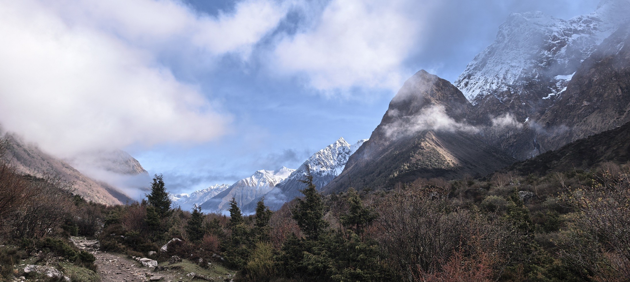
A Perfect wilderness at high altitude on Manaslu Circuit Trek
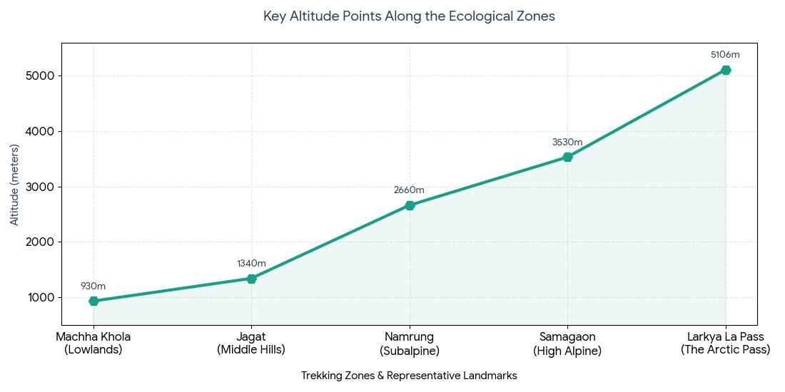
Key Altitude Features of the Manaslu Profile:
Subtropical to Arctic: An extreme temperature and ecosystem transition occurs over a relatively short distance.
Gradual Ascent: The initial days through deep river valleys serve as an excellent natural method of preparing your body and muscles for the climb.
Atmospheric Pressure: By the time you reach the high pass, oxygen density is nearly half of that at sea level.
Trekking Zone
Representative Village / Landmark
Altitude (Meters) | Altitude (Feet) | Main Ecological Environment
Lowlands Start
Machha Khola
930 m | 3,051 ft | Subtropical forest & river canyon
Middle Hills
Jagat (Checkpost)
1,340 m | 4,396 ft | Temperate broadleaf zone
Subalpine
Namrung
2,660 m | 8,727 ft | Cool temperate pine & rhododendron
High Alpine
Samagaon
3,530 m | 11,581 ft | Alpine scrub & Buddhist highlands
The Arctic Pass
Larkya La Pass
5,106 m | 16,752 ft | Glacial moraine & permafrost
The Low-Altitude Gateway: Beginning the Journey from Kathmandu to Machha Khola
Here, the actual start to your high-altitude adventure is a challenging, day-long overland drive. You'll depart from the capital city and follow a road that snakes along rushing rivers and past terraced farmlands and rural communities. While many people used to start further down the trail, the road network has been extended, and most modern itineraries skip the historic Soti Khola starting altitude and begin their main trek in a deeper point within the Budhi Gandaki valley, Machhakhola.
Logistic Particulars of the Route:
Overland Journey: Trekkers will travel along the main Kathmandu to Machhakhola drive routes before taking a sharp turn towards the Gorkha district. Here, the journey involves navigating rough dirt tracks that are carved directly into the steep canyon walls.
Starting Point: Eventually, the vehicular portion of your journey will end at the busy riverside settlement of Machha Khola, at which point you'll continue on foot.
Acclimatization Advantage: Machha Khola sits at an official Machha Khola elevation of 930 meters (3,051 feet). Spending your first night well below any significant altitude-related risks allows your cardiovascular system a gentle introduction to the journey.
Route Option / Milestone
Specific Altitude (Meters) | Specific Altitude (Feet)
Physiological Effect on Trekkers
Kathmandu Valley
1,400 m | 4,593 ft
Baseline from which to depart.
Soti Khola (historic start)
710 m | 2,329 ft
Humid lowlands; largely bypassed now.
Machha Khola (modern start)
930 m | 3,051 ft
Oxygen-rich launching point; good for warming up.
Altitude Comparison: Starting Points
Golden Acclimatization Rule: The most important principle in mountain safety is to always: Climb high, sleep low. Trek to a higher altitude in the afternoon so that your body adapts to the lower oxygen, then descend to sleep in a lower position so it can recuperate and build endurance for the challenges ahead.
The Convenience of an All-Inclusive Trek: If you wish to take the guesswork out of your Himalayan adventure, you can let Haven Holidays Pvt. Ltd. Plan everything for you. Our treks are meticulously planned by experienced local experts who understand high-altitude logistics and have mapped out safe, clear routes so you can concentrate on the amazing journey ahead. Get in touch with our team today to plan your unique Manaslu experience!
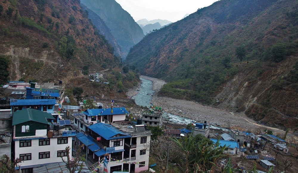
Hiking Along the Budhi Gandaki River: Moving from Tatopani to Jagat
When you leave the lower valleys, lace up your boots and you will be transported to the truly magical, deeper canyon terrain. The Budhi Gandaki river trail takes you along a path cut into steep, vertical cliffs. Along this part of the trek, you'll pass through Tatopani and make your way, progressively uphill.
Actually, this part of the expedition is characterized by dizzyingly beautiful suspension bridges over the roaring, glacier fed river. Although you'll still find yourself in sub tropical, verdant surroundings, and you'll see cascading waterfalls everywhere, the gradual daily ascent of this portion of the trek begins to quietly establish the cardiovascular basis you'll need for higher altitudes.
Main Characteristics of Lower Gorge Terrain :
The Budi Gandaki River: This is the axis along which the path is carved and you can hear the water wherever you go, creating a deep, sonorous tone as you navigate a path constructed within a vertical geological feature, shaped over millennia.
Humid Environment: The steep canyon walls confine moisture, creating a warm, humid climate and relatively oxygen rich environment at this stage of your trek.
Constant Upward Inclines: Short, steep climbs composed of carved stone staircases, coupled with flat river sections allow you to move consistently upwards, with very few truly flat areas.
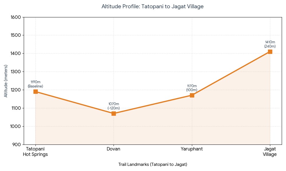
Trail Landmark / Stop
Meters | Feet
Rise from previous section | Notes & Experience
Tatopani Hot Springs
1,190 m | 3,904 ft
Baseline | Hot springs with water seeping from cliffs, humid and steamy.
Dovan
1,070 m | 3,510 ft
-120 m (Dip down) | Drop down and climb back up with the crossing of a major tributary bridge.
Yaruphant
1,170 m | 3,838 ft
+100 m | Flats along the riverbed of river stones followed by stone steps.
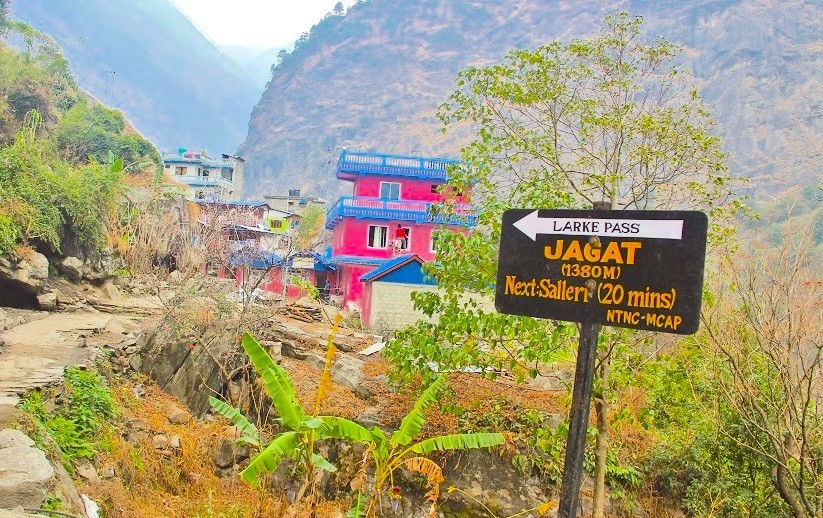
Jagat Village
1,410 m | 4,625 ft
+240 m | Village that serves as the "gateway" of the Restricted area, paved with stones.
Access into Restricted Territory: Crossing 2500m to Namrung
Once you arrive at Jagat village elevation, you have crossed another threshold of the trek. This is where you must have your restricted area documentation checked by local officials. You have officially entered an invisible boundary. You'll notice a change as the subtropical scenery gradually gives way to dense forests of bamboo and pine, and the first clear signs of Tibetan-Buddhist culture emerge. This part of the trek is demanding; a strenuous climb takes you over 2500m to the point where the atmosphere becomes perceptibly thinner and a true change in environment sets in.
Defining Altitude Landmarks :
Forests Transition: From Jagat to Deng, the landscape changes from bamboo thickets and moist deciduous trees to more alpine-like pine and rhododendron forests.
Alpine Views: As you climb, glimpses of the mountains in the Ganesh Himal and Himalchuli range (7,422m and7,893m) are visible, framed by steep cliff faces and trees.
Cultural Markers: mani walls (prayer stones) and stupas appear regularly at this point and above, signaling the rising altitude and your advance into Upper Manaslu.
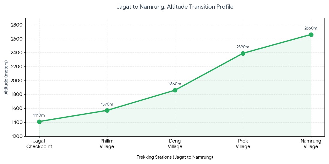
Trekking Station
Meters | Feet
Total Altitude Gained | Oxygen / Climate
Jagat Checkpoint
1,410 m | 4,625 ft
Start | Sub tropical, 100% oxygen density.
Philim village
1,570 m | 5,150 ft
+160 m | Wide Gurung village located above large waterfalls.
Deng village
1,860 m | 6,102 ft
+290 m | Crossroads between trekking routes in the middle altitude.
Prok village
2,390 m | 7,841 ft
+530 m | Higher plateau with old monasteries and views.
Namrung village
2,660 m | 8,727 ft
+270 m | Sub alpine zone, frigid morning air, low oxygen density.
Jagat to Namrung: Altitude Transition
Expert Acclimatization Tip: The most basic and critical rule of mountain travel: Climb high, sleep low. Pushing to higher altitudes during the day ensures your system adjusts to the thin air while allowing your body to rest at a lower, more comfortable altitude overnight, building acclimatization over time.
Full Trek Experience Guarantee: Leave the worry of trip logistics and Manaslu Trek route planning to the local experts at Haven Holidays Pvt. Ltd.. Our treks are designed by knowledgeable local guides who understand every nuance of high-altitude travel, ensuring your trip is as safe and enjoyable as possible while you experience the breathtaking beauty of the Himalayas. Contact us today to plan your custom Manaslu adventure.
Entering the Nubri Valley: The Majestic climb to Lho Village
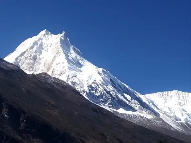
Once you ascend beyond the subalpine confines of Namrung, the route suddenly erupts into the expansive, glacial carved Nubri Valley. Here the scenery radically transforms from forests and farms into windswept, high-altitude landscapes bordering extensive barley fields and traditional stone dwellings. Steadily ascending along this high valley will bring you directly to Lho village, a central religious and cultural heart for the Nubri people of the region.
Actually, the high point for the day is Ribung Monastery, a striking complex set high on a hill above the village; but for all trekkers, Lho presents your first glimpse of the magnificent double peaked summit of Mount Manaslu (8163m) looming directly above the valley floor.
Key sights to expect when entering the Nubri:
Tibetan-Buddhist Culture: Throughout your village visit you will pass row upon row of wooden prayer wheels twirling rhythmically in the breeze generated by mountain air currents.
The Ribung Monastery Ridge: Climbing to the monastery complex on the hillside during the afternoon is a perfect place for contemplation and photographing the landscape.
Prime Manaslu Panorama: Lho Village is truly a premium Manaslu viewpoint from where the towering northeast face of the massif is completely visible.
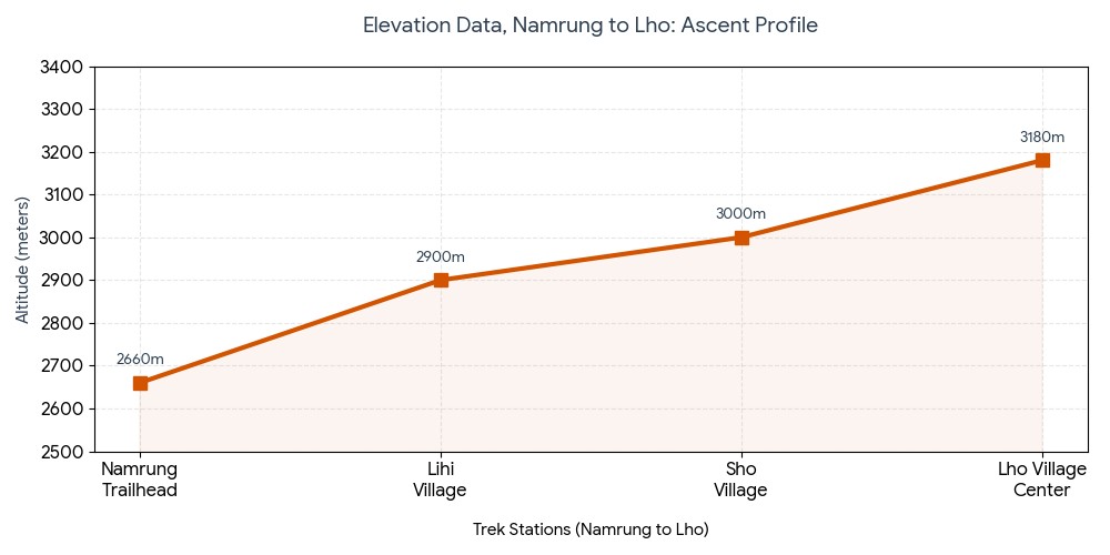
Trek Station / Milestone
Altitude (m) | Altitude (ft)
Change in Elevation | Atmosphere / Landscape
Namrung Trailhead
2660 | 8727
Baseline | Pine forests, morning frost is possible on the path
Lihi Village
2900 | 9514
+240m | Barley fields, multi tiered chortens
Sho Village
3000 | 9842
+100m | Higher altitude, crisper air
Lho Village Center
3180 | 10433
+180m | Nubri capital hub, epic Manaslu views
Elevation data, Namrung to Lho:
Your first major acclimatization point: Arriving in Sama Gaon village
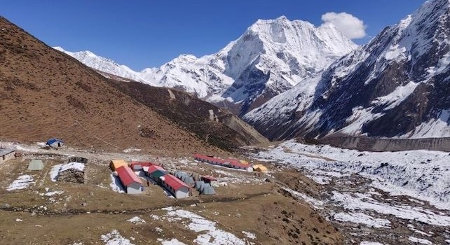
After passing through Lho, you continue along the valley floor, climbing steadily until you reach the vast stone houses of Sama Gaon. Located at 3,530 meters (approximately 11,581 ft), Sama Gaon serves as a crucial physiological resting point in your expedition.
As the human body takes time to adjust to this elevation, ascending past it quickly is extremely risky; thus, establishing a strategic Manaslu acclimatization day routine at Sama Gaon before you ascend above 4,000m is essential.
Key high-altitude excursions for Sama Gaon:
Classical Acclimatization: Begin boosting your red blood cell production through proven hike high sleep low methods on a hike to Birendra Tal or Pungyen Gompa during the day.
Birendra Tal Glacial Lake: The route is flat but highly rewarding on a walk to Birendra Tal (3,450m) at the base of Manaslu glacier. The glacial lake itself presents a striking turquoise landscape.
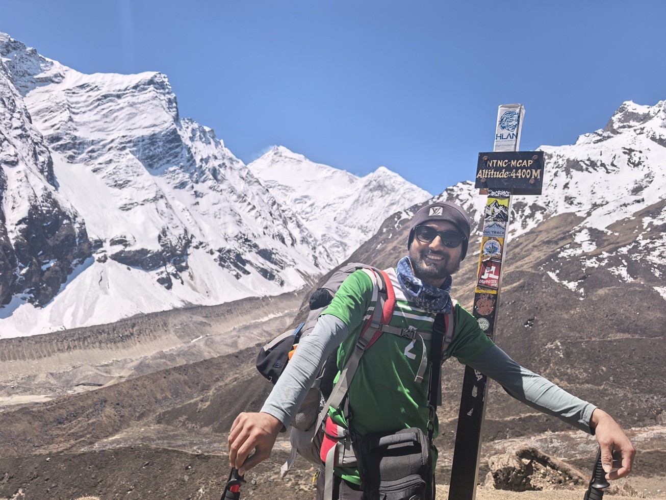
Manaslu Base Camp (MBC): More advanced trekkers may aim for an all-day excursion up to the busy Manaslu Base Camp (4,400m) to stimulate acclimatization via significant altitude gain.
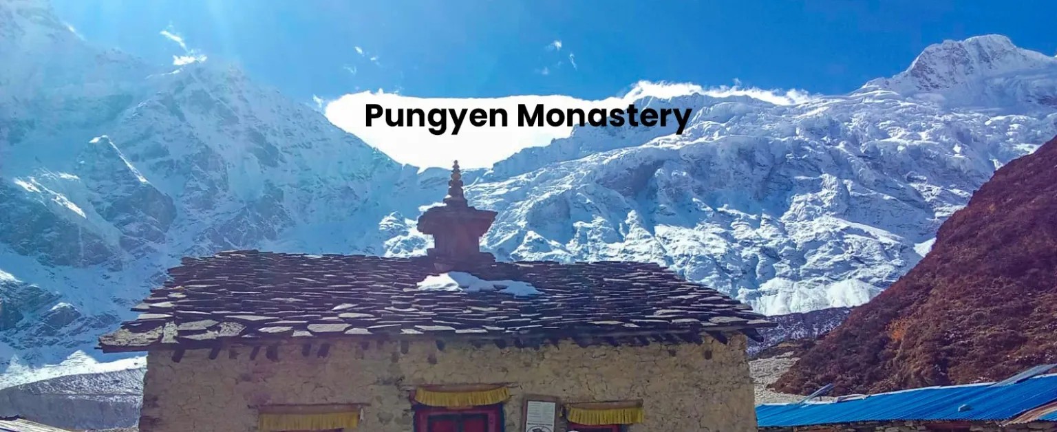
Pungyen Gompa Option: A less frequented but rewarding alternative takes you along a steep track to the ancient monastery Pungyen Gompa (3,870m) directly below the East Face of Manaslu.
Destination
Peak Altitude (m) | Peak Altitude (ft)
Effective Altitude | Purpose & Strategy
Sama Gaon Lodge
3530 | 11581
65% of sea level | Rest & recovery zone; maintain high liquid intake.
Birendra Glacial Lake
3450 | 11318
66% of sea level | Active low-impact recovery for muscle flexibility.
Pungyen Gompa Ridge
3870 | 12696
63% of sea level | Moderate altitude exposure to promote lung capacity.
Manaslu Base Camp
4400 | 14435
59% of sea level | Intense altitude stress to prep for Larkya Pass.
Return to Sama Gaon
3530 | 11581
65% of sea level | High quality sleep and stable heart rate recovery.
Acclimatization success rates for Sama Gaon:
The Golden Rule of Mountain Safety: The primary mantra on any high-altitude journey is to always climb high, sleep low. This strategy requires you to exert yourself at an increased altitude during the day, forcing your body to adapt to the lower pressure, and then to descend to sleep at a lower elevation where recovery is easier. This practice is absolutely crucial for safely ascending the perilous Larkya Pass.
Side Trips for Altitude Adaptation: Trekking to Manaslu Base Camp or Pungyen Gompa
In the high Himalayas, acclimatization is not a passive activity-it is an active process requiring carefully thought-out movement. A vital part of rest in Sama Gaon is making strategically planned side treks that train your lungs and blood vessels. This will push you to a considerably thinner atmosphere and prompt your body to produce the oxygen-carrying red blood cells it will need before you retreat to your comfortable low-altitude lodge for the night.
Each of the two alternative paths takes a radically different path; on the trek to the Manaslu Base Camp altitude, you will ascend through a treacherous, nearly vertical climb of rough glacial moraine as favored by elite climbing teams, whereas the Pungyen Gompa trek elevation provides a more relaxed and culturally enriched ramble through a broad alpine valley ending at an ancient, secluded monastery right under Manaslu's frozen eastern face.
Physiological Advantages of these Adaptation Treks :
Warming up at Birendra Tal Side Trip: Most adaptation treks start with an easy walk alongside Birendra Tal's striking turquoise waters, an ideal glacial lake upon which to begin with a flat stage to warm up muscles.
Activating "High Altitude, Low Sleep": Going to the 4,000m or 4,800m mark for a few hours safely exposes your lungs to a low-oxygen environment (hypoxic), without causing a serious chronic altitude sickness.
Gauge Stamina: The tough side treks will tell you a realistic amount about how your body can cope with rapid changes in elevation just prior to the actual pass crossing.
Side Trek Route
Highest Altitude (M) / Highest Altitude (ft)
Approx Round-Trip Time | Terrain & Main Difficulty
Birendra Tal Lake
3,450 m / 11,318 ft
1.5 – 2 hrs | Level, rocky single-track; no great challenge.
Pungyen Gompa
4,050 m / 13,287 ft
5 – 6 hrs | Smooth meadow ascents; ancient stone monastery views.
Manaslu Base Camp
4,800 m / 15,748 ft
6 – 7 hrs | Very steep, rocky ridges; lose gravel and harsh winds.
Adaptation Hike Profile :
Traveling toward the border of Tibet: A short but steady ascent to Samdo
From Sama Gaon, you will once again begin trekking north. The Budhi Gandaki River will grow more sluggish as you climb. This section is not very long in terms of distance but feels long because of the thin air, which will make each footstep seem much more difficult. You will be traveling to Samdo, a tiny settlement of Tibetan refugees that was founded in the 1950s and is very close to the ancient border passes.
Actually, the village of Samdo village altitude, situated at 3,860 meters (12,664 ft), serves as your second acclimatization stop and final holding ground. The land around the village will be devoid of trees and transform into a stark, arctic tundra like landscape. This is a location in which it is crucial to spend an additional day or an extended afternoon resting, getting rehydrated, and preparing your winter clothing before heading off toward the frigid, empty land ahead of Larkya Pass.
Strategic Considerations at the Border Outpost :
High-Altitude Border Trekking: If you take the valley directly east from Samdo, you will find the Lajyung La Pass, an actively traveled border route between locals and Tibet.
Cold Tundra Climate: Due to the immense altitude, it gets below zero as soon as the sun sets behind the mountain peaks and you will have to put on several layers of clothing quickly.
Last preparations for departure: This village offers simple Lodges and will give you a chance to rest your legs and prepare all of your warm clothes for the final push over the pass.
Trekking segment
Meters / feet
Vertical meters | percentage of sea level oxygen available
Sama Gaon Baseline
3,530 m / 11,581 ft
0 m | approx 65%
Larke Bazaar (ruins)
3,650 m / 11,975 ft
+120 m | approx 64%
Samdo Village
3,860 m / 12,664 ft
+210 m | approx 62%
Elevation changes between Sama Gaon and Samdo Outpost :
A seasoned climber's trick for acclimatization: "Climb high, sleep low" remains a definite rule regarding the safety. By forcing your body to adapt to a higher altitude during your acclimatization walk in the afternoon, you will strengthen it against the low oxygen levels before bringing it back down to a comfortable level to help your body recover and gain the endurance it will need for Larkya Pass.
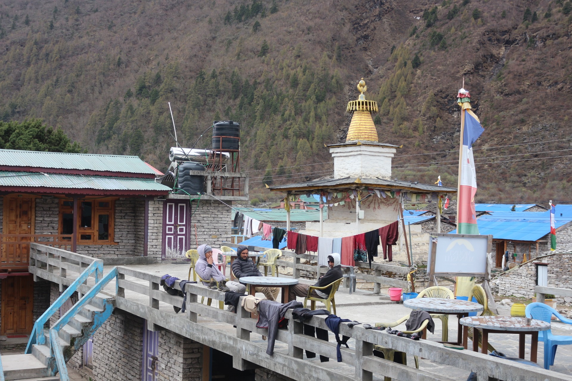
Dharmasala High Camp: Overnight before Larkya Pass
Here, the trail then rises abruptly again from Samdo onto a stark, high alpine tundra and you have to trek across some iced over stream and some moraines of the Larkya Glacier and then you will reach Dharmasala, or commonly known as Larkye phedi (meaning 'foot of the pass').
At Dharmasala high camp elevation of 4,460 m (14,632 ft), Dharmasala is not really a settlement but it is just a temporary camp/staging point. This place consists of the stone huts and some permanent tents which provide an extremely basic but comfortable stay during the trek.
Happy face on the arrival at Dharmasala
Likewise, the real challenge will be sleeping at the high altitude over 4000 m which would mean a significantly lower atmospheric oxygen level (nearly 57% less than sea level) and a single simple act like unbuckling your shoes could leave you gasping for breath. Therefore the primary purpose is nothing but rest and to be ready for the trek of the pass before dawn.
Survival and Comfort at High Camp :
Hydration: You lose fluid through exhalation in the dry cold air at a rapid pace. Drinking 4-5 liters of fluid every day would ensure that your blood is thin and circulate easily.
Refueling: You have to force yourself to eat foods rich in carbohydrates even if you lose appetite due to high altitude to keep the furnace burning efficiently for the next day's tough journey.
Conserving Warmth: As soon as the sun sets behind the rugged granite walls of the mountains the temperature drops significantly below zero and it is crucial to keep yourself warm in warm layers of clothes and in a well-rated sleeping bag to avoid hypothermia.
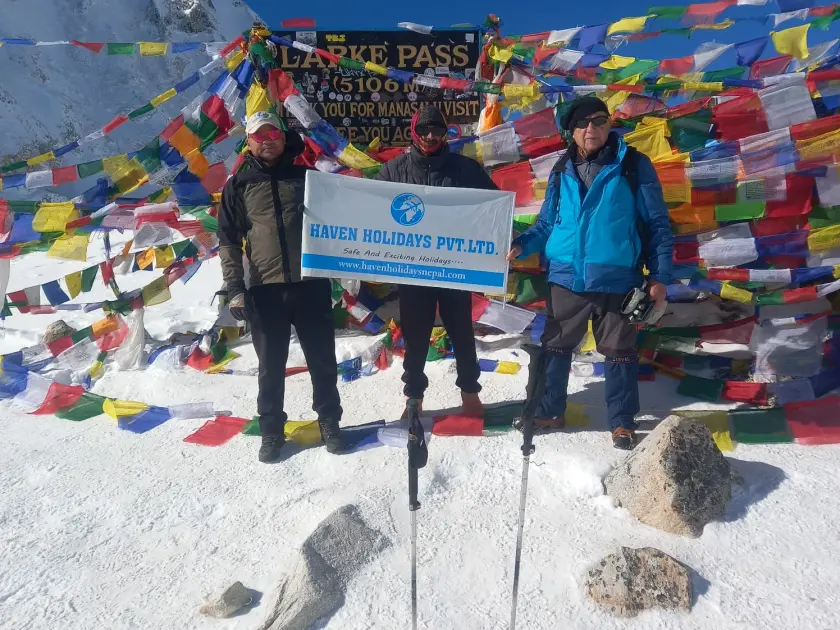
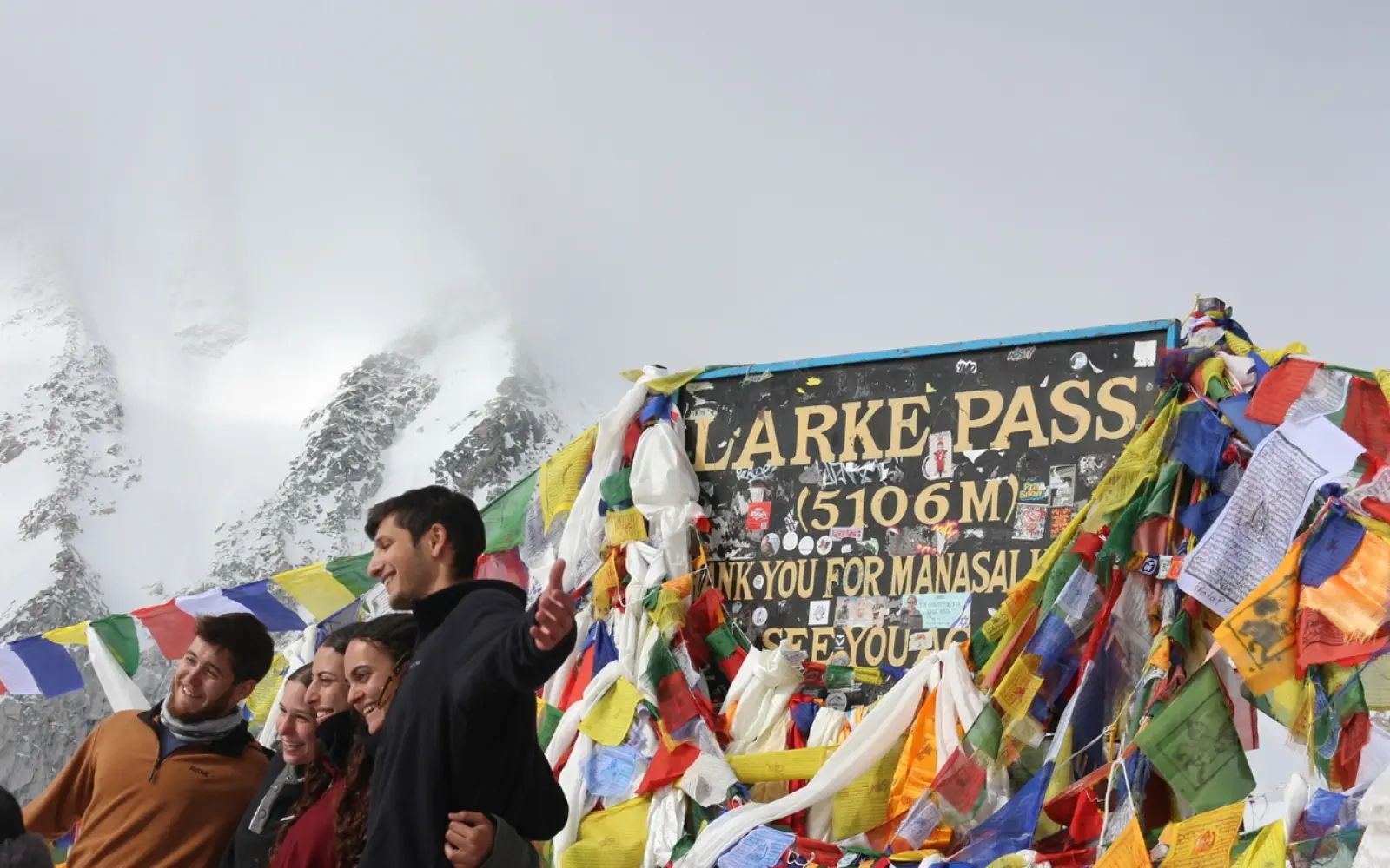
Larkya Pass: Summiting Manaslu Circuit's Highest Point
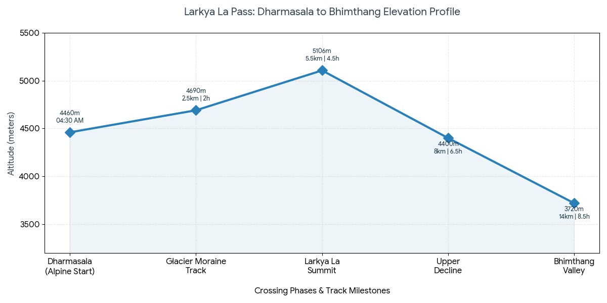
Actually, this will be the ultimate point in the whole Manaslu Circuit trip. Trekking across Larkya Pass(5106m) is the test of your mental strength and endurance. In order to reach the pass safely you are expected to start at 3:30 am and be on the frozen trail by 4:30 am while trekking under the stars.
Starting early in the morning is essential to successfully reach the summit before afternoon, when harsh winds may cause you trouble, along with extreme weather shifts as you would traverse the pass.
While trekking to the highest point on Manaslu circuit you will need to trek along the moraine of the Larkya Glacier and continue walking over high altitude ice fields until you are faced with an almost vertical snow climb over series of steep switchbacks.
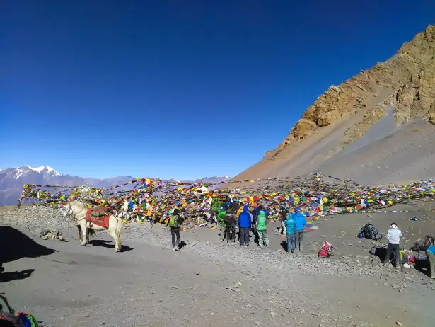
Finally after climbing for approximately 4-5 hours and gaining over 600 m you will reach the peak pass elevation of 5106 m (16,752 ft). The area around the pass is decorated with fluttering prayer flags and from there you can witness the most spectacular alpine panoramas with spectacular view of Himlung Himal (7,126m), Kang Guru (6,981m) and Annapurna II (7,937m).
However reaching the Larkya Pass height is only the beginning. You are then expected to descend 1400m steeply to the beautiful alpine meadow of Bhimthang (3,720m) which is also known as the descent of knee injuries.
Cold, Gear, and Pace management :
Micro-pacing: When at a high altitude it is important to avoid fast pace which would lead to faster exhaustion of your system. Slow short steps can have an equal impact with synchronized breath can lead to stable heart beat.
Dealing with Cold: Extreme cold affects the extremities the most. Proper use of windproof mountaineering gloves, heavy trekking boots with merino wool socks, active headlamp, and beanie will reduce the risk of cold injury.
Traction: The icy paths of the moraine can often get covered with fresh snow which makes it slippery. Trekking poles and micro spikes will give you extra grip and stability.
Phase
Elevation | distance
Est time | Environment & conditions
Alpine start
4460 m | 0 km
04:30 AM | Freezing cold temperatures require good clothing, head lamp and walking over moraine rocks.
Glacier moraine track
4690m | 2.5 km
2 Hours | Following rock piles on the glacier, cold, and clear weather.
Summit
5106m | 5.5 km
4.5 Hours | The Summit, high wind, 51% of oxygen and breathtaking alpine sceneries.
Upper decline
4400m | 8 km
6.5 Hours | Steep and slippery scree, gravels or snowy terrain, requires excellent concentration and grip.
Bhimthang valley
3720m | 14 km
8.5 Hours | alpine meadow, rich oxygen and much less of the cold.
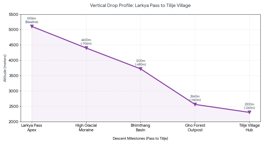
The Sharp Descent of the Alps: Back Down to Bhimthang and Tilije
Reaching the summit of the Larkya pass is a huge and satisfying achievement but physically this is still not the end of the day's efforts. In particular, dropping down from high mountain terrain back into the Western valleys is a sustained and steep downhill trek that really puts your lower joints through their paces. It takes a tremendous amount of concentration to get from the ice and scree of the high altitude out towards the sub alpine pine forests that surround Bhimthang elevation at 3,720 m (~12,204 ft), and you will still be quite tired after a long high altitude day.
Dharmashala – the final stop before Larke La Pass on the Manaslu Circuit Trek, surrounded by rugged beauty and pure Himalayan wilderness.
Coping with the Downhill:
Protecting your joints: Because the upper trail drops a massive 1400 vertical meters through snow, ice, and rocky scree slope, steep downhill knee pain is a problem faced by many trekkers. This can be minimized with use of double trekking poles and taking small steps.
Reclaiming oxygen: Thankfully as you rapidly drop in altitude the air becomes more oxygen rich, providing a vital boost of energy.
The transition from alpine terrain to forest: Once the glacial moraine is behind you, the bleak alpine landscape slowly transforms into the picturesque sub-alpine pine, oak and huge rhododendron forest.
Safe altitude for the night: The following morning you will trek further along the Tilije village trail to reach the much lower altitude of 2,300 m (~7,545 ft) where the air is warm and the cultivated farms represent a safe haven from high altitude mountain trekking.
Stage / Milestone
Target Altitude (m) / Target Altitude (ft)
Net elevation drop | Landscape / Physiological change
Larkya Pass Apex
5106 m / 16752 ft
Baseline | Alpine Zone; Sub zero temperatures; micro spikes required for ice sections.
-680 m | first lodge stop; oxygen recovery begins. Sub alpine meadows.
Gho Forest Outpost
2560 m / 8398 ft
-1160 m | Dense rhododendron and pine forest; Trail soft/muddy.
Tilije Village Hub
2300 m / 7545 ft
-260 m | large settlement; warm climate; zone of safety.
Vertical drop breakdown: Pass to Tilije.
Conclusion: A comprehensive summary of the Manaslu altitude range
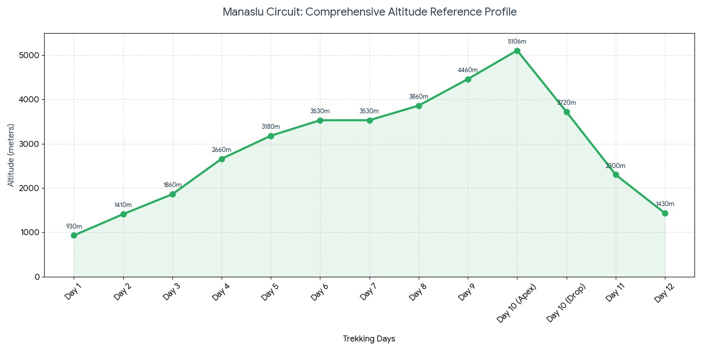
Meanwhile, the key to a successful and life changing trek around the Manaslu and Nubri/Tsum region is mastering the altitude variations. The Manaslu Circuit Trek takes a unique 'loop' route which ascends steeply up the Budhi Gandaki gorge and then drops more gently through the valley of the Marsyangdi River. Thus the Manaslu altitude summary in these regions forms an asymmetrical bell curve where the upward trek is slow and sustained, and the downhill portion steep and short.
Here, this safe trekking itinerary provides a structure for planning your physical preparation for Larkya Pass in relation to daily challenges on the trail.
Manaslu Circuit Trek elevation profile – a dramatic journey from low river valleys to the high Himalayan pass of Larke La.
Final tips for preparing your journey:
Prepare for the 'asymmetrical bell curve: The drop downhill happens nearly twice as fast as the ascent, therefore your training must be based around improving eccentric leg strength (e.g. With lunges and downhill runs) to combat high-impact fatigue in your knees.
Adhere strictly to the schedule of rest days: Especially in Sama Gaon or Samdo, where you will recover and allow your blood to adapt to the higher altitude. Be vigilant about tracking your progress: saving or screenshotting a 'vertical meter graph' can help you track your gains in relation to your physical ability.
Trekking day
The trail and stages
Altitude at end of day (m) | Altitude at end of day (ft) | Daily elevation change (m)
Day 1
Kathmandu to Machha Khola.
930m | 3051ft | +470 m (Driving gain)
Day 2
Machha Khola to Jagat Village checkpoint.
1410m | 4625ft | +480 m (gradual riverside)
Day 3
Jagat village to Deng Restricted Entry point.
1860m | 6102ft | +450 m (steep canyon walk)
Day 4
Deng village to Namrung sub-alpine gateway.
2660m | 8727ft | +800 m (steep forest walk)
Day 5
Namrung to Lho village viewpoint.
3180m | 10433ft | +520 m (early Manaslu views)
Day 6
Lho village to Sama Gaon valley floor.
3530m | 11581ft | +350 m (entry into Nubri Valley)
Day 7
Rest day: Active side trips around Sama Gaon.
3530m | 11581ft | 0 m (sleep low, walk high)
Day 8
Sama Gaon to Samdo border outpost.
3860m | 12664ft | +330 m (border walk, lower oxygen)
Day 9
Samdo to Dharmasala high camp base.
4460m | 14632ft | +600 m (overnight above 4000m)
Day 10
Pass Day: Dharmasala over Larkya Pass.
5106m | 16752ft | +646m to apex peak
Day 10(cont.)
Larkya Pass over the drop to Bhimthang basin.
3720m | 12204ft | -1386m descent drop
Day 11
Bhimthang basin to Tilije village.
2300m | 7545ft | -1420 m (knee jarring descent)
Day 12
Tilije to Dharapani, then drive to Besisahar.
1430m | 4691ft | -870 m (end of foot trekking)
A comprehensive Manaslu circuit altitude reference by day:
In clonclusion, the Manaslu Circuit trek altitude profile takes you through incredibly deep river gorges to high, icy mountain passes. Being able to visualize how much and how quickly this altitude changes will enable you to plan a safe and enjoyable loop around Mt. Manaslu. So, plan to walk between 850m – 5106m above the sea level that is Machhakhola to Larkya Pass. In fact, you have to gain more than 4000m elevation in the entire trek in 10 days. For, this need a comprehensive physical training and mental stability.
Manaslu Circuit trek Altitude Variations- FAQs
1. At what altitude does the Manaslu Circuit trek begin? A standard Manaslu Circuit trek itinerary begins either at Soti Khola or Machha Khola. Both villages are at a low elevation and offer fantastic introductions to the mountainous landscape; you will sleep over 870 meters (2,854 feet) high at Machha Khola which is great for easy acclimatization.
2. What is the highest elevation on the Manaslu Circuit trek?
The Manaslu Circuit trek peaks at a staggering altitude of 5,106 meters (16,752 feet), where the Larkya La Pass separates the Gorkha district from the Marsyangdi River valley. This stunning pass represents the highest point of your journey through the Manaslu Circuit trek altitude profile.
3. How fast is the altitude change along the Manaslu Circuit trek?
The landscape transitions quickly from a hot, subtropical riverside to alpine environments at high altitudes. Within the first five days of the Manaslu Circuit trek itinerary, you can gain over 2,500 meters, rising from less than 1,000 meters to above 3,500 meters, with tremendous variation.
4. Where are the best rest stops and acclimatization villages on the Manaslu Circuit trek?
The most suitable Manaslu Circuit trek itinerary requires overnight rests in the higher villages; we recommend two nights at Samagaon (3,530 meters) and one night at Samdo (3,860 meters). These villages offer incredible opportunities for acclimatization, preventing Acute Mountain Sickness (AMS) before the big pass day.
5. How high is Samagaon, and what are there to see and do?
Samagaon lies at a lofty 3,530 meters (11,581 feet) and offers numerous high-altitude day treks. Our popular choices include the stunning day hike up to Manaslu Base Camp (4,400 meters), or a visit to the beautiful Birendra Lake (3,450 meters). Rest days are often spent at Samagaon to cope with the Manaslu Circuit trek difficulty.
6. What is the altitude profile of the village Samdo?
Samdo is the last village on your route to Larkya La before it begins to climb toward the highest altitude, sitting at 3,860 meters (12,664 feet). This village's position, below the tree line, means you can spend one night here to increase your acclimatization significantly before pushing for the final climb the next day.
7. What altitude is Dharmasala / Larkya Phedi at?
Dharmasala, the base camp from which the ascent of Larkya La begins, is located at an extreme altitude of 4,460 meters (14,632 feet). This is the highest point where you will spend the night on your entire Manaslu Circuit trek altitude profile, so come prepared for cold, basic lodgings and a very early wake-up.
8. How long does it take to ascend Larkya La on the Manaslu Circuit trek?
The summit of Larkya La (5,106m) takes between 4 to 5 hours from Dharmasala, climbing 650 vertical meters as you tackle loose moraine, ice, and scree to reach the prayer flags. This part of the Manaslu Circuit trek difficulty will often start before sunrise.
9. What is the altitude profile of the descent from Larkya La?
After the initial strenuous climb up, the descent can also be arduous and physically demanding. Dropping a steep 1,516 meters, you will arrive in the village of Bimthang (3,590m), which can often involve knee-jarring walking through steep, loose moraine and over ice fields.
10. How does oxygen availability vary along the Manaslu Circuit trek?
At the trailhead, oxygen levels are normal at 100%, but as you ascend, this figure will begin to decrease significantly. For example, at 3,530 meters you'll find that the oxygen level is around 65%, while at 5,106 meters, you will only be breathing about 53% of normal levels, drastically affecting your pace.
11. Is the Manaslu Circuit trek suitable for beginners?
The Manaslu Circuit trek requires significant physical preparation and resilience. While fit beginners can complete it, the higher altitude, more remote wilderness, and sustained climbing are considerably more challenging than the Annapurna Circuit. You will need a strong cardio workout routine in the months prior.
12. What are the costs involved in the Manaslu Circuit trek permits?
Due to its status as a restricted area, the Manaslu Circuit trek cost is a factor that will be added to your budget. A restricted area permit for Manaslu will cost between $75-$100 USD, and you will also need MCAP and ACAP fees that are normally managed by the guiding agency you work with.
13. How do 'climb high, sleep low' principles apply on this trek?
During your time at Samagaon (3,530 meters), guides encourage "climbing high, sleeping low" to aid acclimatization. Day treks such as to Pungyen Gompa (4,050 meters) can increase your body's red blood cell production, helping you adjust to the thinning air before returning to sleep at your lodgings.
14. What are the key signs that you haven't acclimatized properly to the Manaslu altitude?
Failure to acclimatize to the Manaslu altitude profile can result in Acute Mountain Sickness (AMS). The symptoms include headaches, nausea, loss of appetite, and extreme fatigue. Resting, staying hydrated, and descending if these conditions persist or worsen is paramount.
15. Can helicopters be used for rescues on the Manaslu Circuit?
Yes, helicopter rescue services are available on the Manaslu Circuit. It is crucial to ensure your travel insurance includes comprehensive medical evacuation for high-altitude conditions up to 6,000 meters as this region is remote and helicopter rescue is the only feasible method for medical emergency recovery.
16. What is the overall walking distance of the Manaslu Circuit trek?
The full Manaslu Circuit trek distance averages about 177 kilometers (110 miles). You will generally walk between 12 to 15 kilometers a day as you ascend and descend through the dramatic Manaslu Circuit trek altitude profile, taking in stunning vistas along the way.
17. How does the weather change according to altitude on the Manaslu Circuit trek?
The weather along the trek varies considerably. You will encounter warm and humid conditions in the lower valleys, but as you climb, temperatures will drop sharply. Below 0C (32F) at night is expected from Samdo upwards, with snow being common on the higher passes like Larkya La.
18. What specific gear is recommended for the altitude variations and Larkya La?
For a safe trek through the Manaslu Circuit trek altitude profile, proper cold-weather gear is vital. This includes high-loft down jackets, thermal base layers, a windproof and waterproof outer shell, warm gloves and a beanie, polarized sunglasses (especially for Larkya La's snow glare), and micro-spikes or crampons for icy sections.
19. Where does the Manaslu Circuit trek altitude profile conclude?
Your 177 km loop around the world's eighth-highest peak concludes in Dharapani at 1,860 meters. At this point, you will join the popular Annapurna Circuit route, where you will be able to hire a jeep for the return journey back to Kathmandu.
20. Why must I be accompanied by a registered guide for the Manaslu Circuit trek? As a restricted area, government regulations require that trekkers be at least in groups of two, and must be accompanied by a registered local guide for the entire duration of the Manaslu Circuit trek. This ensures your safety as you navigate challenging terrain and adhere to restricted area permit rules.

0.81855800 1738673284.webp)