[{"name":"Everest Base Camp Helicopter Tour","duration":"1","image_url":"https:\/\/www.havenholidaysnepal.com\/storage\/trip-galleries\/1\/thumb_6cd53005d75a86e373d31419d1b14d78.webp","offer_price":1195,"url":"https:\/\/www.havenholidaysnepal.com\/trips\/everest-base-camp-helicopter-tour"},{"name":"Everest Mountain Flight","duration":"1","image_url":"https:\/\/www.havenholidaysnepal.com\/storage\/trip-galleries\/4\/thumb_3b0b4f1d6f72b0ad224daf4752f2c6e0.jpg","offer_price":285,"url":"https:\/\/www.havenholidaysnepal.com\/trips\/everest-mountain-flight"},{"name":"Everest Short Trek","duration":"9","image_url":"https:\/\/www.havenholidaysnepal.com\/storage\/trip-galleries\/5\/thumb_BXPP3621.JPEG0.02033800 1727957098.webp","offer_price":995,"url":"https:\/\/www.havenholidaysnepal.com\/trips\/everest-short-trek"},{"name":"Gokyo Valley Trek","duration":"12","image_url":"https:\/\/www.havenholidaysnepal.com\/storage\/trip-galleries\/6\/thumb_10bc469b14731f23d3ce84a7092ad53f.jpg","offer_price":1195,"url":"https:\/\/www.havenholidaysnepal.com\/trips\/gokyo-valley-trek"},{"name":"15 days Annapurna Base Camp Trek","duration":"15","image_url":"https:\/\/www.havenholidaysnepal.com\/storage\/trip-galleries\/7\/thumb_87d1533bc45faf070990aef0579e4be4.jpg0.81855100 1728285496.webp","offer_price":785,"url":"https:\/\/www.havenholidaysnepal.com\/trips\/15-days-annapurna-base-camp-trek"},{"name":"Nepal Pilgrimage Tour","duration":"14","image_url":"https:\/\/www.havenholidaysnepal.com\/storage\/trip-galleries\/8\/thumb_02c3bcf2ad2e8a4c1703e90ae747b5f1.jpg","offer_price":1475,"url":"https:\/\/www.havenholidaysnepal.com\/trips\/nepal-pilgrimage-tour"},{"name":"UNESCO World Heritage Site Tour","duration":"10","image_url":"https:\/\/www.havenholidaysnepal.com\/storage\/trip-galleries\/9\/thumb_unesco-world-heritage-site-Lumbani-temple-buddhists-hindus-kathmandu-nepal0.36988600 17347617740.93089500 1737469667.webp","offer_price":715,"url":"https:\/\/www.havenholidaysnepal.com\/trips\/unesco-world-heritage-site-tour"},{"name":"Island Peak Climbing","duration":"16","image_url":"https:\/\/www.havenholidaysnepal.com\/storage\/trip-galleries\/11\/thumb_Island peak0.53947000 1734692503.webp","offer_price":2495,"url":"https:\/\/www.havenholidaysnepal.com\/trips\/island-peak-climbing"},{"name":"Upper Mustang Trek","duration":"18","image_url":"https:\/\/www.havenholidaysnepal.com\/storage\/trip-galleries\/12\/thumb_upper mustang 7 Oct-2024.jpg0.95398900 1728286166.webp","offer_price":2995,"url":"https:\/\/www.havenholidaysnepal.com\/trips\/upper-mustang-trek"},{"name":"Annapurna Circuit Trek","duration":"16","image_url":"https:\/\/www.havenholidaysnepal.com\/storage\/trip-galleries\/15\/thumb_tibetan-flags.jpg0.04843900 1728289138.webp","offer_price":985,"url":"https:\/\/www.havenholidaysnepal.com\/trips\/annapurna-circuit-trek"},{"name":"Gosainkunda Lake Trek","duration":"10","image_url":"https:\/\/www.havenholidaysnepal.com\/storage\/trip-galleries\/16\/thumb_5A8083B3-C007-41A8-853F-D0C37C97D235_1_105_c.jpeg0.52581200 1731845258.webp","offer_price":595,"url":"https:\/\/www.havenholidaysnepal.com\/trips\/gosainkunda-lake-trek"},{"name":"Zip-lining in Pokhara and Dhulikhel","duration":"1","image_url":"https:\/\/www.havenholidaysnepal.com\/storage\/trip-galleries\/18\/thumb_215f765e2ebc995dd5c800b4bfdbacc3.jpg","offer_price":82,"url":"https:\/\/www.havenholidaysnepal.com\/trips\/zip-lining-in-pokhara-and-dhulikhel"},{"name":"Annapurna Heli Tour","duration":"1","image_url":"https:\/\/www.havenholidaysnepal.com\/storage\/trip-galleries\/19\/thumb_d71a6bbb9fd4da8d1b567a5cdbdec85d.jpg","offer_price":555,"url":"https:\/\/www.havenholidaysnepal.com\/trips\/annapurna-heli-tour"},{"name":"Paragliding in Pokhara","duration":"1","image_url":"https:\/\/www.havenholidaysnepal.com\/storage\/trip-galleries\/20\/thumb_de788d2dd9726783431f882c007efae1.jpg","offer_price":65,"url":"https:\/\/www.havenholidaysnepal.com\/trips\/paragliding-in-pokhara"},{"name":"Ultra-Flight in Pokhara","duration":"1","image_url":"https:\/\/www.havenholidaysnepal.com\/storage\/trip-galleries\/21\/thumb_e27a9fb572a5c21611bb2a3c18e4b8f0.jpeg","offer_price":175,"url":"https:\/\/www.havenholidaysnepal.com\/trips\/ultra-flight-in-pokhara"},{"name":"Sarangkot Hiking","duration":"1","image_url":"https:\/\/www.havenholidaysnepal.com\/storage\/trip-galleries\/22\/thumb_100ef822fea19987166c6c1366215f15.jpg","offer_price":55,"url":"https:\/\/www.havenholidaysnepal.com\/trips\/sarangkot-hiking"},{"name":"Mera Peak Climbing","duration":"18","image_url":"https:\/\/www.havenholidaysnepal.com\/storage\/trip-galleries\/24\/thumb_d16ae3895f678cf26ffbf2455f541fb5.jpg0.31883400 1732617790.webp","offer_price":2475,"url":"https:\/\/www.havenholidaysnepal.com\/trips\/mera-peak-climbing"},{"name":"Lower Dolpo Trek","duration":"18","image_url":"https:\/\/www.havenholidaysnepal.com\/storage\/trip-galleries\/26\/thumb_Dolpo Galary - 1.JPG0.37725200 1727939952.webp","offer_price":2995,"url":"https:\/\/www.havenholidaysnepal.com\/trips\/lower-dolpo-trek"},{"name":"Nagarkot Sunrise\/Sunset Tour","duration":"1","image_url":"https:\/\/www.havenholidaysnepal.com\/storage\/trip-galleries\/27\/thumb_5147a5532644283a380f2e86f3857c13.jpg0.17748000 1728488108.webp","offer_price":30,"url":"https:\/\/www.havenholidaysnepal.com\/trips\/nagarkot-sunrise-sunset-tour"},{"name":"16 day Everest Base Camp Trek","duration":"16","image_url":"https:\/\/www.havenholidaysnepal.com\/storage\/trip-galleries\/28\/thumb_IMG_4311.JPG0.64984800 1727942213.webp","offer_price":1475,"url":"https:\/\/www.havenholidaysnepal.com\/trips\/16-day-everest-base-camp-trek"},{"name":"Ghorepani Poon Hill trek with Jungle Safari and Trishuli River Rafting -13 days","duration":"13","image_url":"https:\/\/www.havenholidaysnepal.com\/storage\/trip-galleries\/29\/thumb_Ghorepani Poon hill.jpg0.48460800 1728281439.webp","offer_price":795,"url":"https:\/\/www.havenholidaysnepal.com\/trips\/ghorepani-poon-hill-trek-with-jungle-safari-and-trishuli-river-rafting--13-days"},{"name":"Mardi Himal Trek","duration":"12","image_url":"https:\/\/www.havenholidaysnepal.com\/storage\/trip-galleries\/30\/thumb_s1.jpg0.62112600 1728200721.webp","offer_price":795,"url":"https:\/\/www.havenholidaysnepal.com\/trips\/mardi-himal-trek"},{"name":"Langtang Valley Trekking","duration":"10","image_url":"https:\/\/www.havenholidaysnepal.com\/storage\/trip-galleries\/31\/thumb_IMG_4702.JPG0.84916500 1727958504.webp","offer_price":685,"url":"https:\/\/www.havenholidaysnepal.com\/trips\/langtang-valley-trekking"},{"name":"Real Adventure Tour in Nepal","duration":"9","image_url":"https:\/\/www.havenholidaysnepal.com\/storage\/trip-galleries\/32\/thumb_ebd1b8cc78d90abe8b9003dd9a2f25bf.jpg0.82151300 1728213516.webp","offer_price":695,"url":"https:\/\/www.havenholidaysnepal.com\/trips\/real-adventure-tour-in-nepal"},{"name":"Luxury Tour in Nepal","duration":"10","image_url":"https:\/\/www.havenholidaysnepal.com\/storage\/trip-galleries\/33\/thumb_8574e61b252b18676b042caf30d830df.jpg","offer_price":1675,"url":"https:\/\/www.havenholidaysnepal.com\/trips\/luxury-tour-in-nepal"},{"name":"Luxury Everest Panorama Trek With EBC Heli Sightseeing","duration":"8","image_url":"https:\/\/www.havenholidaysnepal.com\/storage\/trip-galleries\/34\/thumb_URZL2397.JPEG0.01209600 1728027820.webp","offer_price":2575,"url":"https:\/\/www.havenholidaysnepal.com\/trips\/luxury-everest-panorama-trek-with-ebc-heli-sightseeing"},{"name":"13 day Everest Base Camp Trek with Helicopter","duration":"13","image_url":"https:\/\/www.havenholidaysnepal.com\/storage\/trip-galleries\/35\/thumb_IMG_4292.JPG0.70131500 1728029276.webp","offer_price":2095,"url":"https:\/\/www.havenholidaysnepal.com\/trips\/13-day-everest-base-camp-trek-with-helicopter"},{"name":"Manaslu Circuit Trek","duration":"16","image_url":"https:\/\/www.havenholidaysnepal.com\/storage\/trip-galleries\/36\/thumb_Mt Manaslu 03-Oct-2024.jpg0.65804900 1727938470.webp","offer_price":955,"url":"https:\/\/www.havenholidaysnepal.com\/trips\/manaslu-circuit-trek"},{"name":"Kanchenjunga Base Camp Trek","duration":"21","image_url":"https:\/\/www.havenholidaysnepal.com\/storage\/trip-galleries\/37\/thumb_Kanchanjunga Trek -!.jpg0.54744400 1727938497.webp","offer_price":2275,"url":"https:\/\/www.havenholidaysnepal.com\/trips\/kanchenjunga-base-camp-trek"},{"name":"Ganesh Himal and Sing-La Trek","duration":"18","image_url":"https:\/\/www.havenholidaysnepal.com\/storage\/trip-galleries\/38\/thumb_Ganesh Himal slider-1.jpg0.43764500 1727937722.webp","offer_price":2975,"url":"https:\/\/www.havenholidaysnepal.com\/trips\/ganesh-himal-and-sing-la-trek"},{"name":"Island Peak Climb with Everest Base Camp Trek","duration":"21","image_url":"https:\/\/www.havenholidaysnepal.com\/storage\/trip-galleries\/39\/thumb_2be428730fe83525bc85a010564f99de.jpg","offer_price":2750,"url":"https:\/\/www.havenholidaysnepal.com\/trips\/island-peak-climb-with-everest-base-camp-trek"},{"name":"Students' Adventure Tour in Nepal","duration":"12","image_url":"https:\/\/www.havenholidaysnepal.com\/storage\/trip-galleries\/41\/thumb_a926d22fbfe08cba271c41ac289b3fd2.jpg","offer_price":995,"url":"https:\/\/www.havenholidaysnepal.com\/trips\/students-adventure-tour-in-nepal"},{"name":"7 Day Poonhill Trek","duration":"7","image_url":"https:\/\/www.havenholidaysnepal.com\/storage\/trip-galleries\/42\/thumb_6196bd69036473293a2c24cc21ed57d7.jpg0.10880600 1728205378.webp","offer_price":555,"url":"https:\/\/www.havenholidaysnepal.com\/trips\/7-day-poonhill-trek"},{"name":"7 Days Annapurna Base Camp Trek","duration":"7","image_url":"https:\/\/www.havenholidaysnepal.com\/storage\/trip-galleries\/43\/thumb_IMG_2214.JPG0.08204900 1728202033.webp","offer_price":355,"url":"https:\/\/www.havenholidaysnepal.com\/trips\/7-days-annapurna-base-camp-trek"},{"name":"3 days Poonhill Trek","duration":"3","image_url":"https:\/\/www.havenholidaysnepal.com\/storage\/trip-galleries\/44\/thumb_Poon hill.jpg0.60816600 1731412954.webp","offer_price":165,"url":"https:\/\/www.havenholidaysnepal.com\/trips\/3-days-poonhill-trek"},{"name":"Poon Hill Luxury Trek with Chitwan-12 days","duration":"12","image_url":"https:\/\/www.havenholidaysnepal.com\/storage\/trip-galleries\/45\/thumb_Poom hill.jpg0.52074500 1730180532.webp","offer_price":1175,"url":"https:\/\/www.havenholidaysnepal.com\/trips\/poon-hill-luxury-trek-with-chitwan-12-days"},{"name":"Everest Luxury Trek-7 days","duration":"7","image_url":"https:\/\/www.havenholidaysnepal.com\/storage\/trip-galleries\/46\/thumb_ACRX9330.JPEG0.93236200 1728031275.webp","offer_price":1975,"url":"https:\/\/www.havenholidaysnepal.com\/trips\/everest-luxury-trek-7-days"},{"name":"Hindu Pilgrimage Tour in Nepal-10 days","duration":"10","image_url":"https:\/\/www.havenholidaysnepal.com\/storage\/trip-galleries\/47\/thumb_a94bf96a4d31decb419f6f828a3280d2.jpg","offer_price":995,"url":"https:\/\/www.havenholidaysnepal.com\/trips\/hindu-pilgrimage-tour-in-nepal-10-days"},{"name":"Everest Base Camp Short Trek-12 days","duration":"12","image_url":"https:\/\/www.havenholidaysnepal.com\/storage\/trip-galleries\/48\/thumb_IMG_4311.JPG0.52680100 1727945154.webp","offer_price":995,"url":"https:\/\/www.havenholidaysnepal.com\/trips\/everest-base-camp-short-trek-12-days"},{"name":"Everest Base Camp Hike 12 Days","duration":"12","image_url":"https:\/\/www.havenholidaysnepal.com\/storage\/trip-galleries\/49\/thumb_IMG_4260.JPG0.51729100 1728061234.webp","offer_price":1295,"url":"https:\/\/www.havenholidaysnepal.com\/trips\/everest-base-camp-hike-12-days"},{"name":"11 Days Everest Base Camp Trek","duration":"11","image_url":"https:\/\/www.havenholidaysnepal.com\/storage\/trip-galleries\/50\/thumb_IMG_4249.JPG0.21392500 1727946959.webp","offer_price":985,"url":"https:\/\/www.havenholidaysnepal.com\/trips\/11-days-everest-base-camp-trek"},{"name":"6 Days Annapurna Base Camp Trek","duration":"6","image_url":"https:\/\/www.havenholidaysnepal.com\/storage\/trip-galleries\/51\/thumb_6 days Abc.jpg0.58185400 1728200798.webp","offer_price":285,"url":"https:\/\/www.havenholidaysnepal.com\/trips\/6-days-annapurna-base-camp-trek"},{"name":"Annapurna Base Camp Trek","duration":"8","image_url":"https:\/\/www.havenholidaysnepal.com\/storage\/trip-galleries\/52\/thumb_IMG_2214.JPG0.29415700 1729487656.webp","offer_price":585,"url":"https:\/\/www.havenholidaysnepal.com\/trips\/annapurna-base-camp-trek"},{"name":"Everest Base Camp Trek with Helicopter Fly Out 10 Days","duration":"10","image_url":"https:\/\/www.havenholidaysnepal.com\/storage\/trip-galleries\/53\/thumb_IMG_4328.JPG0.52056600 1728058444.webp","offer_price":1875,"url":"https:\/\/www.havenholidaysnepal.com\/trips\/everest-base-camp-trek-with-helicopter-fly-out-10-days"},{"name":"Everest Base Camp Trek 14 Days","duration":"14","image_url":"https:\/\/www.havenholidaysnepal.com\/storage\/trip-galleries\/54\/thumb_Everest Base Camp Trek 14 days Oct 3 2024.JPG0.43202700 1727939745.webp","offer_price":1455,"url":"https:\/\/www.havenholidaysnepal.com\/trips\/everest-base-camp-trek-14-days"},{"name":"ABC Trek with Poonhill 11 Days","duration":"11","image_url":"https:\/\/www.havenholidaysnepal.com\/storage\/trip-galleries\/55\/thumb_ABC with fishtail.JPG0.21441100 1728277965.webp","offer_price":555,"url":"https:\/\/www.havenholidaysnepal.com\/trips\/abc-trek-with-poonhill-11-days"},{"name":"Muldai Hill Trek 9 Days","duration":"9","image_url":"https:\/\/www.havenholidaysnepal.com\/storage\/trip-galleries\/56\/thumb_7efee59f0a8c6817c8255bd2b9f3539d.jpeg0.19479300 1728213091.webp","offer_price":675,"url":"https:\/\/www.havenholidaysnepal.com\/trips\/muldai-hill-trek-9-days"},{"name":"Mardi Himal Trek 6 days","duration":"6","image_url":"https:\/\/www.havenholidaysnepal.com\/storage\/trip-galleries\/57\/thumb_slider 1.jpeg0.36909700 1728184981.webp","offer_price":590,"url":"https:\/\/www.havenholidaysnepal.com\/trips\/mardi-himal-trek-6-days"},{"name":"Mardi Himal Trek 7 days","duration":"7","image_url":"https:\/\/www.havenholidaysnepal.com\/storage\/trip-galleries\/58\/thumb_slider1.jpg0.61666600 1728206414.webp","offer_price":620,"url":"https:\/\/www.havenholidaysnepal.com\/trips\/mardi-himal-trek-7-days"},{"name":"Mardi Himal Trek 8 Days","duration":"8","image_url":"https:\/\/www.havenholidaysnepal.com\/storage\/trip-galleries\/59\/thumb_sli1.jpg0.38569100 1728206631.webp","offer_price":695,"url":"https:\/\/www.havenholidaysnepal.com\/trips\/mardi-himal-trek-8-days"},{"name":"14 Days Manaslu Trek","duration":"14","image_url":"https:\/\/www.havenholidaysnepal.com\/storage\/trip-galleries\/60\/thumb_sunrise-mt-manaslu-during-manaslu-circuit-larke-pass-trekking-himalaya-nepal (1)0.81855800 1738673284.webp","offer_price":885,"url":"https:\/\/www.havenholidaysnepal.com\/trips\/14-days-manaslu-trek"},{"name":"Dhampus-Sarangkot Trek with Chitwan 8 days","duration":"8","image_url":"https:\/\/www.havenholidaysnepal.com\/storage\/trip-galleries\/61\/thumb_Sarangkot Bhangyang.jpg0.75461400 1728210333.webp","offer_price":790,"url":"https:\/\/www.havenholidaysnepal.com\/trips\/dhampus-sarangkot-trek-with-chitwan-8-days"},{"name":"7 Days Golden Triangle Tour","duration":"7","image_url":"https:\/\/www.havenholidaysnepal.com\/storage\/trip-galleries\/62\/thumb_311ce1d117ee0ba75402a7c301bcdf830.73532400 1739179809.webp","offer_price":845,"url":"https:\/\/www.havenholidaysnepal.com\/trips\/7-days-golden-triangle-tour"},{"name":"Annapurna Circuit Trek 12 days","duration":"12","image_url":"https:\/\/www.havenholidaysnepal.com\/storage\/trip-galleries\/63\/thumb_IMG_20161024_092237.jpg0.57796600 1728289938.webp","offer_price":695,"url":"https:\/\/www.havenholidaysnepal.com\/trips\/annapurna-circuit-trek-12-days"},{"name":"Everest Base Camp Budget Trek 16 Days","duration":"16","image_url":"https:\/\/www.havenholidaysnepal.com\/storage\/trip-galleries\/64\/thumb_IMG_4423.JPG0.92579200 1728144669.webp","offer_price":958,"url":"https:\/\/www.havenholidaysnepal.com\/trips\/everest-base-camp-budget-trek-16-days"},{"name":"Poonhill Budget Trek 7 Days","duration":"7","image_url":"https:\/\/www.havenholidaysnepal.com\/storage\/trip-galleries\/65\/thumb_5be067852d0c5228d6f3155bc425c6b5.jpg","offer_price":395,"url":"https:\/\/www.havenholidaysnepal.com\/trips\/poonhill-budget-trek-7-days"},{"name":"Annapurna Base Camp Budget Trek 8 Days","duration":"8","image_url":"https:\/\/www.havenholidaysnepal.com\/storage\/trip-galleries\/66\/thumb_Pokhara.jpg0.16188000 1728212001.webp","offer_price":375,"url":"https:\/\/www.havenholidaysnepal.com\/trips\/annapurna-base-camp-budget-trek-8-days"},{"name":"The Real UNESCO Seven World Heritage Tour in Kathmandu 4 days","duration":"4","image_url":"https:\/\/www.havenholidaysnepal.com\/storage\/trip-galleries\/67\/thumb_Baudha Stupa.JPG0.63906900 1728201021.webp","offer_price":380,"url":"https:\/\/www.havenholidaysnepal.com\/trips\/the-real-unesco-seven-world-heritage-tour-in-kathmandu-4-days"},{"name":"Everest Base Camp Jeep Ride with Helicopter Return","duration":"14","image_url":"https:\/\/www.havenholidaysnepal.com\/storage\/trip-galleries\/68\/thumb_788ee5b63a6efb6f3c3d048b4270daca.JPG","offer_price":1895,"url":"https:\/\/www.havenholidaysnepal.com\/trips\/everest-base-camp-jeep-ride-with-helicopter-return"},{"name":"Annapurna Base Camp Jeep Ride with Helicopter Return 7 days","duration":"7","image_url":"https:\/\/www.havenholidaysnepal.com\/storage\/trip-galleries\/69\/thumb_abc jeep.jpg0.10280600 1728204064.webp","offer_price":1455,"url":"https:\/\/www.havenholidaysnepal.com\/trips\/annapurna-base-camp-jeep-ride-with-helicopter-return-7-days"},{"name":"Everest Base Camp Trek","duration":"15","image_url":"https:\/\/www.havenholidaysnepal.com\/storage\/trip-galleries\/70\/thumb_Everest Base Camp Trek 3 oct- 2024.JPG0.58445300 1727941472.webp","offer_price":1575,"url":"https:\/\/www.havenholidaysnepal.com\/trips\/everest-base-camp-trek"},{"name":"7 UNESCO World Heritage Tour Kathmandu 2 days","duration":"2","image_url":"https:\/\/www.havenholidaysnepal.com\/storage\/trip-galleries\/72\/thumb_Bhaktipur 3.jpg0.05559600 1728201496.webp","offer_price":150,"url":"https:\/\/www.havenholidaysnepal.com\/trips\/7-unesco-world-heritage-tour-kathmandu-2-days"},{"name":"Day Tour to UNESCO Heritage Sites","duration":"1","image_url":"https:\/\/www.havenholidaysnepal.com\/storage\/trip-galleries\/73\/thumb_228A1018.jpg0.79892500 1728199793.webp","offer_price":55,"url":"https:\/\/www.havenholidaysnepal.com\/trips\/day-tour-to-unesco-heritage-sites"},{"name":"Golden Triangle Tour in Nepal","duration":"8","image_url":"https:\/\/www.havenholidaysnepal.com\/storage\/trip-galleries\/74\/thumb_f54139cf9100f00015ffe0400687e946.webp","offer_price":588,"url":"https:\/\/www.havenholidaysnepal.com\/trips\/golden-triangle-tour-in-nepal"},{"name":"Everest Base Camp Honeymoon Tour by Helicopter with Pokhara","duration":"7 days","image_url":"https:\/\/www.havenholidaysnepal.com\/storage\/trip-galleries\/76\/thumb_RJTL7517.JPEG0.40261600 1731499989.webp","offer_price":9999,"url":"https:\/\/www.havenholidaysnepal.com\/trips\/everest-base-camp-honeymoon-tour-by-helicopter-with-pokhara"},{"name":"Yoga and Meditation Retreat Tour in Nepal","duration":"10 days","image_url":"https:\/\/www.havenholidaysnepal.com\/storage\/trip-galleries\/77\/thumb_decf8e33-6617-4400-9df0-63bf75509adf.JPG0.51948300 1731574810.webp","offer_price":2575,"url":"https:\/\/www.havenholidaysnepal.com\/trips\/yoga-and-meditation-retreat-tour-in-nepal"},{"name":"Chisapani-Nagarkot Trek","duration":"3","image_url":"https:\/\/www.havenholidaysnepal.com\/storage\/trip-galleries\/78\/thumb_0b64dfceaeab48ac36d685476bdebafb.webp","offer_price":165,"url":"https:\/\/www.havenholidaysnepal.com\/trips\/chisapani-nagarkot-trek"},{"name":"Chitwan Jungle Safari Tour","duration":"2","image_url":"https:\/\/www.havenholidaysnepal.com\/storage\/trip-galleries\/79\/thumb_IMG_1696.JPG0.28467800 1733054554.webp","offer_price":175,"url":"https:\/\/www.havenholidaysnepal.com\/trips\/chitwan-jungle-safari-tour"},{"name":"Kailash Overland Tour","duration":"16","image_url":"https:\/\/www.havenholidaysnepal.com\/storage\/trip-galleries\/80\/thumb_PA2605230.68496700 1735818657.webp","offer_price":2495,"url":"https:\/\/www.havenholidaysnepal.com\/trips\/kailash-overland-tour"},{"name":"4 nights 5 days Bhutan Tour","duration":"5","image_url":"https:\/\/www.havenholidaysnepal.com\/storage\/trip-galleries\/81\/thumb_PB0508470.23069500 1735828937.webp","offer_price":1265,"url":"https:\/\/www.havenholidaysnepal.com\/trips\/4-nights-5-days-bhutan-tour"},{"name":"Everest Base Camp Trek Without Flying","duration":"16","image_url":"https:\/\/www.havenholidaysnepal.com\/storage\/trip-galleries\/82\/thumb_308b054484eddc042e092e1ae2ae5586.webp","offer_price":685,"url":"https:\/\/www.havenholidaysnepal.com\/trips\/everest-base-camp-trek-without-flying"},{"name":"Everest Base Camp Trek by Land","duration":"16","image_url":"https:\/\/www.havenholidaysnepal.com\/storage\/trip-galleries\/83\/thumb_8f0f2784a3ae7343d193b64fe8d47c96.webp","offer_price":675,"url":"https:\/\/www.havenholidaysnepal.com\/trips\/everest-base-camp-trek-by-land"},{"name":"Everest Base Camp Trek by Jeep","duration":"16","image_url":"https:\/\/www.havenholidaysnepal.com\/storage\/trip-galleries\/84\/thumb_f82b3acdfc933bc3e0197624c001b0a6.webp","offer_price":675,"url":"https:\/\/www.havenholidaysnepal.com\/trips\/everest-base-camp-trek-by-jeep"},{"name":"Everest Base Camp Trek without Lukla Flight","duration":"16","image_url":"https:\/\/www.havenholidaysnepal.com\/storage\/trip-galleries\/85\/thumb_2d0acc76dc958e3122a3745074989914.webp","offer_price":675,"url":"https:\/\/www.havenholidaysnepal.com\/trips\/everest-base-camp-trek-without-lukla-flight"},{"name":"Langtang Valley Trek","duration":"7","image_url":"https:\/\/www.havenholidaysnepal.com\/storage\/trip-galleries\/86\/thumb_a845db06c5feada1478e8aed659fce97.webp","offer_price":199,"url":"https:\/\/www.havenholidaysnepal.com\/trips\/langtang-valley-trek"},{"name":"Everest Base Camp Trek with Gokyo Lake","duration":"17","image_url":"https:\/\/www.havenholidaysnepal.com\/storage\/trip-galleries\/87\/thumb_c6aa32f7654f2eda78134bc84ac70b79.webp","offer_price":1885,"url":"https:\/\/www.havenholidaysnepal.com\/trips\/everest-base-camp-trek-with-gokyo-lake"},{"name":"Everest Three Passes Trek","duration":"19","image_url":"https:\/\/www.havenholidaysnepal.com\/storage\/trip-galleries\/88\/thumb_db5364eaab56f5755da55868f8ca4258.webp","offer_price":1735,"url":"https:\/\/www.havenholidaysnepal.com\/trips\/everest-three-passes-trek"},{"name":"Annapurna Base Camp Trek From Pokhara","duration":"5","image_url":"https:\/\/www.havenholidaysnepal.com\/storage\/trip-galleries\/89\/thumb_49c813cf1054ff06108963924a78ee88.webp","offer_price":255,"url":"https:\/\/www.havenholidaysnepal.com\/trips\/annapurna-base-camp-trek-from-pokhara"},{"name":"Sarangkot Sunrise Tour from Pokhara","duration":"1","image_url":"https:\/\/www.havenholidaysnepal.com\/storage\/trip-galleries\/90\/thumb_932d995b8fb702634a23e8f9a0432c6e.webp","offer_price":35,"url":"https:\/\/www.havenholidaysnepal.com\/trips\/sarangkot-sunrise-tour-from-pokhara"},{"name":"Langtang Valley Trek-8 days","duration":"8","image_url":"https:\/\/www.havenholidaysnepal.com\/storage\/trip-galleries\/91\/thumb_81d3d0a6979c9ed01f65d5ade53820b2.webp","offer_price":250,"url":"https:\/\/www.havenholidaysnepal.com\/trips\/langtang-valley-trek-8-days"},{"name":"Manaslu Circuit Trek 12 days","duration":"12","image_url":"https:\/\/www.havenholidaysnepal.com\/storage\/trip-galleries\/92\/thumb_d8251bbef0c8a246a02bda5c150a27c2.webp","offer_price":675,"url":"https:\/\/www.havenholidaysnepal.com\/trips\/manaslu-circuit-trek-12-days"},{"name":"2 Days Poon Hill Trek","duration":"2","image_url":"https:\/\/www.havenholidaysnepal.com\/storage\/trip-galleries\/93\/thumb_9d8fa8f60767538857d6c7cb3a7fee8b.webp","offer_price":150,"url":"https:\/\/www.havenholidaysnepal.com\/trips\/2-days-poon-hill-trek"},{"name":"Upper Mustang Jeep Tour","duration":"6","image_url":"https:\/\/www.havenholidaysnepal.com\/storage\/trip-galleries\/94\/thumb_9a3098a6c860b87ad3339773ef5435b9.webp","offer_price":1095,"url":"https:\/\/www.havenholidaysnepal.com\/trips\/upper-mustang-jeep-tour"},{"name":"Tsum Valley Trek","duration":"11","image_url":"https:\/\/www.havenholidaysnepal.com\/storage\/trip-galleries\/95\/thumb_704a6a1eb293553827633dbd8ad7d22c.webp","offer_price":775,"url":"https:\/\/www.havenholidaysnepal.com\/trips\/tsum-valley-trek"},{"name":"Mardi Himal Trek from Pokhara","duration":"4","image_url":"https:\/\/www.havenholidaysnepal.com\/storage\/trip-galleries\/96\/thumb_c92e9ee49c2564a11c7a9ba593439efc.webp","offer_price":295,"url":"https:\/\/www.havenholidaysnepal.com\/trips\/mardi-himal-trek-from-pokhara"},{"name":"4 Days Poon Hill Trek","duration":"4","image_url":"https:\/\/www.havenholidaysnepal.com\/storage\/trip-galleries\/97\/thumb_c349e182edd0858f3e3409d945f0d2ec.webp","offer_price":215,"url":"https:\/\/www.havenholidaysnepal.com\/trips\/4-days-poon-hill-trek"},{"name":"Poon Hill Sunrise Jeep Tour from Pokhara","duration":"2","image_url":"https:\/\/www.havenholidaysnepal.com\/storage\/trip-galleries\/98\/thumb_509875052b16f6f9156db386e3592eb8.webp","offer_price":260,"url":"https:\/\/www.havenholidaysnepal.com\/trips\/poon-hill-sunrise-jeep-tour-from-pokhara"},{"name":"Muktinath Jeep Tour from Pokhara","duration":"3","image_url":"https:\/\/www.havenholidaysnepal.com\/storage\/trip-galleries\/99\/thumb_1651790cb7422703fe86d472a35d4f90.webp","offer_price":255,"url":"https:\/\/www.havenholidaysnepal.com\/trips\/muktinath-jeep-tour-from-pokhara"},{"name":"Ghorepani Poon Hill Trek from Pokhara","duration":"5","image_url":"https:\/\/www.havenholidaysnepal.com\/storage\/trip-galleries\/100\/thumb_27fa62452af4ea8e08544aaa035cc446.webp","offer_price":295,"url":"https:\/\/www.havenholidaysnepal.com\/trips\/ghorepani-poon-hill-trek-from-pokhara"},{"name":"Ghandruk, Poon Hill, Muktinath and Upper Mustang Tour","duration":"7 days","image_url":"https:\/\/www.havenholidaysnepal.com\/storage\/trip-galleries\/101\/thumb_a7dd15032cd9693005233b1df7dc63d3.webp","offer_price":685,"url":"https:\/\/www.havenholidaysnepal.com\/trips\/ghandruk-poon-hill-muktinath-and-upper-mustang-tour"},{"name":"Nar Phu Valley Trek with Annapurna Circuit","duration":"16 days","image_url":"https:\/\/www.havenholidaysnepal.com\/storage\/trip-galleries\/102\/thumb_21f5af1d6f698a6898b64413bcc19c69.webp","offer_price":1395,"url":"https:\/\/www.havenholidaysnepal.com\/trips\/nar-phu-valley-trek-with-annapurna-circuit"},{"name":"Poon Hill-Jhino Danda Hot Spring Trek","duration":"4","image_url":"https:\/\/www.havenholidaysnepal.com\/storage\/trip-galleries\/103\/thumb_b1a8563edaf102468aab613332282c6c.webp","offer_price":215,"url":"https:\/\/www.havenholidaysnepal.com\/trips\/poon-hill-jhino-danda-hot-spring-trek"},{"name":"Annapurna Base Camp Trek with Helicopter Return","duration":"4","image_url":"https:\/\/www.havenholidaysnepal.com\/storage\/trip-galleries\/104\/thumb_928d650987e2db5f449127b41966da53.webp","offer_price":895,"url":"https:\/\/www.havenholidaysnepal.com\/trips\/annapurna-base-camp-trek-with-helicopter-return"},{"name":"Annapurna Circuit with Tilicho Lake Trek","duration":"10","image_url":"https:\/\/www.havenholidaysnepal.com\/storage\/trip-galleries\/105\/thumb_a8c9d8bf4041c0fa676d6c239abfd24c.webp","offer_price":615,"url":"https:\/\/www.havenholidaysnepal.com\/trips\/annapurna-circuit-with-tilicho-lake-trek"}]
Introduction to Manaslu Circuit Trek: Discovering Nepal's Hidden Himalayan Treasure
Meanwhile, the Manaslu Circuit Trek is a little-known Himalayan treasure in Nepal. Trekkers navigate remote valleys, cross lofty passes, and encounter genuine culture. This loop encircles the enigmatic Mount Manaslu (8,163 m), the eighth-highest summit on Earth. The Manaslu Circuit Trek route offers varied scenery—from subtropical jungle to alpine pasture. Villages such as Sama Gaon (3,530 m) reveal Tibetan-inspired spiritual life. Observers behold snow-capped summits, icy streams, and fauna in the Manaslu Conservation Area. Compared to routes in Annapurna or Everest, this trek is less frequented. Explorers relish the tranquility, unspoiled surroundings, and authentic warmth of hosts. The Manaslu Circuit showcases Nepal's unexplored wonders and rich traditions. Overall, it presents a memorable expedition through one of Himalaya's most undeveloped areas.
Starting from the Budhi Gandaki Valley, Machhakhola, trekkers ascend through the lush greenery of terraces, pine forests, and local villages. They ascend gradually to the Larke Pass at 5,160 meters which provides magnificent views of distant peaks like Manaslu. After passing through the Himalayan landscape into the Annapurna region, they conclude their trek at Besisahar (760 meters) via Dharapani. Combining cultural nuances with strenuous hill walks, accommodations are simple village teahouses that offer hearty fare. Trekkers can also encounter rare flora and fauna such as the Himalayan blue sheep and snow leopards. The route exhibits incredible shifts in scenery from verdant forests to stark highland passes. It gifts trekkers with scenic Himalayan panoramas and peaceful seclusion.
To conclude, the Manaslu Circuit Trek offers an exhilarating experience—the wilderness of Himalaya interlaced with traditional life.
Key Facts about the Manaslu Circuit Trek:
Duration: 14–18 days typical itinerary
Distance: Approximately 177 km loop
Highest point: Larkya La Pass (5,160 m)
Difficulty: Moderate to strenuous
Best seasons: March–May and September–November
Permits required: Restricted Area Permit (RAP), Manaslu Conservation Area Permit (MCAP), Annapurna Conservation Area Permit (ACAP) and Local Tsum Nubri Entry Permit
Mandatory: Licensed guide and at least one porter
Starting point: Machha Khola (890 m) or Soti Khola (700 m)
11 Cross Larke Pass (5,106 m) to Bimtang (3,720 m)
Highest point
Panoramic summit views.
12–14 Bimtang to Besisahar
760 m
Descent Forest trails, end of trek.
Origins of Manaslu Trekking: Restrictions before 1991 and its first ascents
Actually, the Manaslu region had been forbidden to foreigners as well as local population for many years prior to 1991. This restriction was put by government owing to its close vicinity to Tibet border. So government wanted to protect the culture of local people and also wanted to keep the security by prohibiting the entry of foreigners to the region unless by permission. This prohibition kept the tradition and natural environment of region preserved for longer period even during the era of mountaineering expeditions. Travelers were provided with permits for expeditions than on any regular basis. There were stiff limitations and restrictions and provided with relatively inadequate infrastructure facilities.
So the Manaslu region yet remained to be the world's arcane corner for several years. The local population in the region yet kept themselves away from modernization in peace and tranquility. In general, those restrictions kept the area not accessible of the world as within the one of the least developed Himalayan zones of Nepal.
Here, the Manaslu expeditions that can be described as a launching pad for the development of the modern trekking trails took place. H.W. Tilman, a renowned British weather beard, touched the region in 1950. In his account about the region, he described it as having significant beauty. The first successful elevation of Manaslu (8,163 meters) was committed by Toshio Imanishi, a Japanese mountaineer, in 1956, who was soon joined by Gyalzen Norbu an also with a Sherpa porter. As a result, he became one of the first foreigners whose successful climb to the summit (8,163meters) was to draw international attention to the peak.
Again, a team of the researchers also made reconnaissance trips in the 1950s. They established the valleys around the massif and investigated feasible climbing routes. Mountaineering in the region continued providing charges with fruitful knowledge of the terrain. These efforts gained so much significance that the Himalayas open to growing number of travelers in succeeding days.
Finally, in 1991, the region's circuit emerged accessible to modern trekkers inaugurating an era of treasure trove trekking in the region.
Historical Timeline of Manaslu Region Access:
1950: H.W. Tilman explores the area as part of a reconnaissance trek
1956: First ascent of Manaslu (8,163 m) by Japanese team
1991: Nepal officially opens Manaslu Circuit to foreign trekkers
Post-1991: Establishment of conservation area and basic trails
Key Early Expeditions to Mt. Manaslu:
Year
Expedition Leader
Key Achievement | Elevation Reached
1950
H.W. Tilman
First modern exploration of the valley | Various low passes.
1953
Japanese team (recon)
Mapping of Manaslu approaches | Up to base camp areas
1956
Toshio Imanishi &Gyalzen Norbu
First summit of Manaslu (8,163 m) 8,163 m summit
1970s
Various teams
Additional climbs and surveys | Multiple peaks over 7,000 m
Official Opening in 1991: How Nepal Opened the Manaslu Region to Trekkers
In1991, Nepal officially opened the Manaslu region to foreigners. Nepal lifted decades of restrictions citing border security issues with Tibet. Government officials wanted to encourage controlled tourism while safeguarding culture. They introduced increasingly popular special permits to govern access. Trekkers could now venture into the Budhi Gandaki Valley and circumnavigate Mount Manaslu(8,163m).
Actually, this landmark event was preceded by hundreds of years of isolation from the1950s onward. Visitors experienced intact wilderness and traditional societies. The administration was concerned with long-term sustainable development. Officials implemented regulations and procedures for protecting flora and fauna. In short, this unprecedented alteration released Nepal's secret treasure on the global stage.
Likewise, the change in policy in 1991 converted the isolated Manaslu region into a trekking destination for the first time. The Nepal government ensured the development of tourism was beneficial to the economy and respectful of culture. The new system mandated entry fees and permits for restricted areas. Trekkers followed centuries-old salt-trading routes across the river. New settlements such as Jagat(1,340m)grew accustomed to the presence of the first wave of globally dispersed hikers. Mountaineers had previously summited the summit, but trekking was non-existent. This initiative developed new sources of revenue through local guiding enterprises.
Moreover, protecting the environment was integral to the short-term plans. Further safeguards were put in place to study the effects of visitors. In essence, the prime permit unlocked potential conservation while embracing adventure.
Key Events Leading to 1991 Opening:
1950: H.W. Tilman explores the region during reconnaissance.
1956: First ascent of Manaslu (8,163 m) by Japanese team.
1950s–1980s: Area restricted due to Tibet border proximity.
1991: Nepal government officially permits foreign trekkers.
1997–1998: Manaslu Conservation Area Project (MCAP) established for protection.
Permit Introduction and Initial Regulations:
Aspect
Details in 1991
Purpose
Restricted Area Permit (RAP)
Required for entry between Jagat (1,340 m) and Dharapani (1,860 m)
Control visitor numbers and ensure security
Group Requirement
Minimum two trekkers plus licensed guide
Support local employment and safety
Conservation Focus
Linked to MCAP initiatives
Protect environment and culture
Initial Visitor Numbers
Around 400 in 1992
Prevent overcrowding unlike Annapurna
Impacts of Opening Bullet List:
Boosted local economies in villages like Sama Gaon (3,530 m).
Followed ancient trade routes, enhancing cultural exchanges.
Drew attention to biodiversity in the conservation area.
Early 1990s Struggles: Difficult Trails, Minimal Facilities, and Restricted Access to Manaslu
In the 1990s, trekkers encountered difficult trails in the Manaslu region. Trails crossed high passes like Larkya La and steep descents to remote villages. Side-hills created relentless ascents and descents. Leech-infested jungle and rocky paths challenged. Landslides damaged paths during winter and spring. Heavy rains washed away paths annually. Bridges over high rivers often collapsed. Villages provided little shelter in tiny wooden shacks. Electricity and communications operated little if at all. Facilities were lacking and medical attention minimal. Remote locations caused long waits for helicopter evacuation. Altitude sickness arose while crossing mountain passes. Accessibility required long long-distance bus trips. In brief, all of these hardships tested humanity in the early '90s.
Here, limited services constituted the Manaslu trek in the '90s. Hotels offered thin mattresses and flimsy walls. Big luxury details did not exist. Good hot showers and heating systems stayed absent at altitude. Dining choices remained simple fare with local ingredients. Independent travel did not occur, limiting options. Permits created bureaucratic obstacles. Distant locations meant slower medical response. Weather and snow forced earlier or later trekking weeks. Few visitors trekked in 1992 around 400 trekkers. Overall, these disadvantages helped keep things rugged yet requirements total concentration.
Early Trail Challenges List:
Steep, uneven paths from Machha Khola (890 m) to Deng (1,860 m).
Frequent landslides during monsoons, blocking routes.
Narrow forest paths and suspension bridges over rivers.
Rocky terrain increased injury risks without proper gear.
Sudden weather shifts added slick ice or snow hazards.
Infrastructure Limitations in 1990s:
Category
1990s Reality
Impact on Trekkers
Accommodation
Basic teahouses in villages like Namrung (2,630 m)
Limited comfort, cold nights
Facilities
No electricity, inconsistent water
Relied on headlamps, basic hygiene
Medical Access
Scarce clinics, no helicopters
High risk for altitude issues
Transportation
Rough bus rides to Soti Khola (700 m)
Long, uncomfortable starts
Access and Permit Hurdles for Manaslu Circuit Trek List:
Mandatory restricted permits from 1991 onward.
No solo access; groups of at least two required.
Limited roads delayed supply deliveries.
Basic communication hindered rescue coordination.
Low visitor numbers (under 1,000 annually) kept area isolated.
Manaslu Conservation Area established in 1998: Conserving Biodiversity & Culture
In December 1998, the government established the Manaslu Conservation Area. It aimed to protect fragile ecosystems and culture and to expound the area’s extraordinary diversity. Management was handed to the National Trust for Nature Conservation (NTNC) via the Manaslu Conservation Area Project (MCAP). The creation of the conservation zone came with challenges like illegal farming, poaching, and overharvesting since trekking in 1991. The 1,663 sq km zone occupies northern Gorkha.
Actually, district lining the country's border with Tibet, rising from subtropical plains to Mount Manaslu (8,163m). Promoting community engagement while yielding benefits to inhabitants, the declaration effectively pioneered integrated preservation efforts in parallel with sustainable right development. Kathmandu, with conservation aid from donors, observed the initiative as a milestone.
Before establishment of Manaslu Conservation Area, the implementing body of the MCAP rolled out integral programs. NTNC centered on community-based custodianship as a long-term solution. Stakeholders control resources and benefit from eco-tourism. The environmental zone conserves thus long, bio-diverse flora and fauna, and monasteries and paintings of Tibetan culture inhabit settlements like Sama Gaon(3,530m).
Also, Manaslu Conservation Area has limited environmental degradation resulting from rising tourism. Enforcement measures aim to safeguard the pristine natural environment. Trekking pack fees funded such endeavors. From thus, the declaration created a responsible tourism model, having harmonized the conservation of a protected Himalayan region with its cultures.
Key Facts about Manaslu Conservation Area Establishment:
Declared: December 28, 1998
Area: 1,663 sq km (642 sq mi)
Elevation range: 1,400 m to 8,163 m (Mount Manaslu summit)
Governing body: NTNC via MCAP (initial 10-year handover)
Main objectives: Combat deforestation, poaching, unsustainable extraction
Bordering regions: Annapurna Conservation Area to west, Tibet to north
Biodiversity and Wildlife Protected Bullet List:
Mammals: 33 species including snow leopard, musk deer, Himalayan tahr.
Birds: Over 110 species recorded.
Reptiles: 3 species present.
Amphibians: At least 4 frog species (e.g., Amolopsformosus).
Plants: 1,500–2,000 flowering plant species.
Bio-climatic zones: Subtropical to nival (permanent snow).
The 2000s Boom: Promotion as an Alternative – More Remote than Everest & Annapurna Routes
Actually, the Manaslu Circuit became more popular in the 2000s as an alternative trek. When opened for trekking, the region was heavily promoted to offset congestion in Everest and Annapurna routes. The trekkers were craving for wilderness, primitive cultures, and minimal presence of other hikers. The area had comparable Himalayan majesty minus the commercialization.
Despite the heavy regulation of travel in it, the number of visitors incrementally increased once conservation efforts grasped access. The guides stressed the spectacular views of Larke Pass (5,106 m) and traditional villages on route. Travel marketing highlighted loneliness and untouched scenery. To conclude, in the decade, the Manaslu gained notoriety as an off-the-beaten-path favorite.
Here, promotion methods propelled the Manaslu throughout the decade. Travel agencies promoted it as "the new Annapurna" with pure adventure exploits. The state and travel companies warned of less ecological degradation. Trekker's learned about the cultural intrigue at Samdo (3,860 m). Trekkers numbers escalated from several hundred to several thousand every year. The trek was best for seasoned hikers (previous trekking experience) who avoid mass tourism. Lodging facilities lacked but continued improvements emerged along the trail. Positive reports facilitated the word-of-mouth promotion. Therefore, the Manaslu became well recognized as an Eco-preserving, satisfying option in Nepal.
Visitor Growth in the 2000s and Early Trends Bullet List:
Early 2000s: Low numbers post-1991 opening, focus on promotion.
Mid-2000s: Steady increase as alternative to Annapurna Circuit.
Post-2010: Numbers often above 3,000 annually (pre-2015 dip).
Comparison: Far fewer than Annapurna's 100,000+ yearly visitors.
Reasons for 2000s Manaslu Circuit Popularity Growth Bullet List:
Marketed as quieter option after Annapurna overcrowding concerns
Offered similar high passes (Larke pass 5,106 m) with fewer people
Highlighted biodiversity in conservation area
Attracted trekkers seeking genuine local interactions
Positive feedback increased visibility in guidebooks and forums
Developing Infrastructure in Manaslu Region: Camping to Tea Houses and Bridge Upgrades over two decades
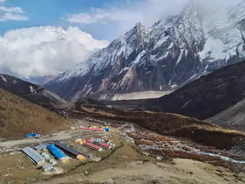
Infrastructure improved hundreds of percent on the Manaslu Circuit over two decades. In the 1990s and early 2000s, trekking expeditions depended solely on camping. Most of the study sites had no shops and basic accommodation was being developed slowly in last 2010s.
Here, villages such as Namrung (2,630 m) and Sama Gaon (3,530 m) were developed with basic lodges. The administration improved the suspension bridges at numerous locations along the course of the Budhi Gandaki River. Some sections of trails experienced repairs including steps made on landslide-prone slopes to mitigate risks of further landslides. Alterations in the overall infrastructure made the trek safer and convenient for trekking.
Presently, tea houses offer beds and other adult/child beverages. In essence, the transformation of the infrastructure from the camping trek to tea house trek a performance of the remote hill district destinations of Manaslu.
Hence, the improvements took pace during the 2010s and operationalized in the 2020s on Manaslu Circuit Trail. The infrastructures in the neighboring lower hill villages of Deng (1,860 m), and Lho (3,180 m) were further enhanced by the local proprietors. Better bridges replaced unstable stone crossings. Roads were built up to higher altitudes to reduce trekking period at the start of the trek.
Likewise, supporting amenities such as power supply, and sanitation facilities got upgraded in many tea houses. The recent changes concentrate on the sustainability of the electricity and different eco-friendly materials above 3, 000 meters. The trekkers can now expect reliable shelter facilities close to the base of the Mount Manaslu (8,163 m).
Key Infrastructure Developments along Manaslu Circuit Trail:
Period - Accommodation Type
Bridge/Trail Upgrades
Impact on Trekking
1990s–2000s - Camping only
Basic, unstable bridges over rivers
High self-sufficiency required
Early 2010s - Basic teahouses emerge
Initial bridge replacements
Lighter packs, more comfort
Mid-2010s - Teahouses in most villages
Improved suspension bridges
Reliable shelter up to Dharmasala (4,480 m)
2020–2025 - Upgraded rooms, solar power
Enhanced trail sections, landslide defenses
Safer, more hygienic experience
Current Infrastructure Highlights List:
Teahouses reliable in lower/mid areas (e.g., Jagat 1,340 m to Sama Gaon 3,530 m).
Basic but improving above 4,000 m.
Better road access to Machha Khola (890 m).
Eco-friendly lodges reduce environmental impact.
Current Status: A Restricted, Off-the-Beaten-Path Trek with Special Permits and Guided Requirements
Indeed, the region around the Manaslu Circuit has today stayed a restricted area off the beaten track. Close to the Tibet border, the region has one of the highest conservation and cultural sensitivities. The trekkers have to obtain special permits via agencies. Solo trekking is not yet allowed. Guides are provided to all groups. This ensures the safety of the guides from treacherous conditions and the protection of the fragile ecosystems and local customs. These two factors also ensure that the authentic culture of the small villages like the Samdo (3,860 m) does not get transformed by horde of mass tourism. The remote location near Mount Manaslu (8,163 m) ensures a solitude experience. In conclusion, encumbrances such as these would guarantee that the circuit remains a real journey into nature as experienced in other untouched regions of Himalaya. Actually, the strict regulations on guided trek and permits remaining in effect in the year 2026. Authorities have suspended areas below two travelers per group. All groups guided for the safety of the groups and respect of the cultures. The permits combine restricted area fees with additional conservation costs. Officials ensure the documentation. Regions entice explorers to wilderness. Transports facilitate comfort without overdevelopment. Travelers choose pristine routes to the Larke Pass (5,160 m). To conclude, the region has been relatively far away from human encroachments and remains a genuine adventure into Himalaya.
Current Permit Requirements (2026):
Permit Type
Cost (Peak: Sep–Nov)
Cost (Off-Season: Dec–Aug) - Notes
Restricted Area Permit (RAP)
USD 100 first 7 days + USD 15/day - USD 75 first 7 days + USD 10/day
Mandatory; through agency only
Manaslu Conservation Area Permit (MCAP)
NPR 3,000 (USD 25–25)
Same - Funds conservation efforts
Annapurna Conservation Area Permit (ACAP)
NPR 3,000 (USD 25–25)
Same - For descent into Annapurna region
Guided Trek and Restriction Rules Bullet List:
Minimum group: 2 trekkers (or pay extra for "ghost" permit).
Mandatory: Licensed Nepali guide.
No solo trekking allowed.
Permits only via registered trekking agencies.
Checkpoints enforce compliance.
Current Status Key Facts List:
Visitor numbers: Low compared to Everest/Annapurna region.
Restricted due to border security, biodiversity protection.
Guided requirement supports local jobs and safety.
Best for experienced trekkers seeking solitude.
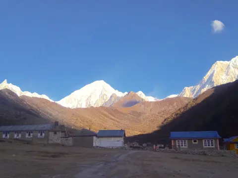
Present-Day Attractions: Diverse Landscapes, Gurung and Tibetan Villages, and Larke Pass at 5,106m
In the present, the Manaslu Circuit Trekking is a feast to the eyes due to its various topographies. The trekkers have the chance of getting amazed with the lush subtropical forests, terraced fields & alpine meadows. The crossing of turbulent rivers & the empty moraines near Mount Manaslu (8,163 m) are other magnificent experiences. The warm hospitality and the traditional customs and life of the Gurung settlements present the special features of the trek. The other settlements under the Tibetan influence, with the prayer flags and ancient monasteries, have a distinct appeal.
Actually, the trek is summated at the Larke Pass (5,106 m), the highest point in the trek from which a number of huge peaks can be seen in the panoramic view. To sum up the highlights of the trek, they are the natural beauty, cultural richness and high altitude exhilaration in one shot.
Today, the natural features of Manaslu region have drawn the experienced trekkers into this isolated trail. The beauty of the features is more impressively shifting from the lush plains to the gliding high passes on the trek. Low-lying Gurung settlements share the customs, legends and arts and crafts of their communities in the lower valleys. The Tibetan border communities like Samdo (3,860 m) still maintain their past decade's dynasties. The views of the heavenly peaks from the Larke Pass at the elevation of 5,106 meters are awe inspiring. The animals observed along the route love to excite the trekkers with their presence. The trekkers never miss authentic experiences and thus they can have glorious memories of nature, ethnicity and treks.
Present-Day Key Attractions List
Diverse landscapes: Subtropical forests to glacial moraines
Gurung villages: Traditional homes, terraced farms in mid-elevations
Tibetan villages: Monasteries, chortens, prayer wheels in upper areas
Wildlife: Snow leopards, blue sheep in Manaslu Conservation Area
High pass highlight: Larke Pass (5,106 m) with 360-degree views
Mountain vistas: Close-up sights of Manaslu (8,163 m), Himlung Himal, Annapurna II
Major Attractions and Elevations:
Attraction
Location/Elevation
Description
Subtropical start
Machha Khola (890 m)
Lush forests, waterfalls, river gorges
Gurung villages
Jagat (1,340 m) to Deng (1,860 m)
Terraced fields, local hospitality
Tibetan-style settlements
Sama Gaon (3,530 m), Samdo (3,860 m)
Monasteries, Buddhist culture, border views
Larke Pass
5,106 m
Snowy/icy crossing, panoramic Himalayan views
Descent landscapes
Bimthang (3,720 m) onward
Alpine meadows to rhododendron forests.
Cultural and Natural Highlights List on Manaslu Circuit Trek:
Authentic interactions in Gurung and Nubri communities
Buddhist gompas and stupas in high villages
Biodiversity: Over 110 bird species, rare mammals
Scenic changes every day from low to high altitude
Modern Changes in Manaslu region. Road projects defining start points and effects of hotter temperatures on trail
Actually, development projects redefine the Manaslu Circuit Trek nowadays. Road departments push the roads near starting points for the trek into the mountains. This causes a change of trek starting points: trekkers previous used to start at Soti Khola (700 m), now they start at Machha Khola (890 m). The upgrading of the road network allows for easier access: The first day of a trek was until recently a matter of 8 hour long jeep rides and now it can be reduced to 3 hours.
But it also exposes this part of a trek to dust and occasional vehicles. This makes ridges near low altitude easier to reach but the old feeling of emptiness is diminished. The partially trans-Himalayan climate also influences the trail. To sum up, changing infrastructure and climate result in a new trekking experience.
In fact, the effects of rising temperatures are evident on the trail nowadays as well. Since the climbing seasons are getting warmer, glaciers in the Himalaya melt faster than they did a decade ago. The glaciers around Larke Pass (5,106 m) already display precarious looking moraines. Landslide danger increases with rising altitudes on the shoulder seasons. Snow lines all over rise higher up the high passes than they did before.
Also, the general weather pattern becomes less predictable. The modernization of infrastructure allows for better access but also for increased elevation of a modern trek. Small communities adapt with new teahouses on trek routes. Modernization warrants access while bring modern concerns to the forefront.
Road Development Changes on Manaslu Circuit Trail:
New start point: Machha Khola (890 m) replaces Soti Khola in many itineraries
Road extensions: To Jagat (1,340 m) and beyond in lower valley
Benefits: Shorter drives from Kathmandu, easier logistics
Drawbacks: Dusty trails, occasional traffic in low sections
Ongoing work: Improves access but keeps upper trail remote
Climate Impacts from Rising Temperatures:
Change
Description
Impact on Trek
Glacier retreat
Faster melt near Manaslu (8,163 m)
Unstable paths, new moraine risks
Shifting snow lines
Higher permanent snow on Larkya La (5,106 m)
Less snow in pass, more ice/slippery descent
Increased landslides
Warmer, erratic rains in mid-elevations
Trail blockages, especially post-monsoon
Unpredictable weather
Rapid temperature swings above 3,000 m
Altitude sickness risk, sudden storms
Warmer lower sections
Higher daytime temps in subtropical areas
Hotter starts, more hydration needed
Modern Changes Summary List:
Infrastructure: Better roads shorten approaches to Machha Khola (890 m)
Climate: Rising temps melt glaciers, alter high-pass conditions
Adaptation: More stable trails in places, but new hazards emerge
Awaiting Technological Innovations on Manaslu region in the Future: GPS, Digital Maps & the Internet based Permit System ensuring more Accessibility
Actually, advanced technological innovations promise a drastically easier trek along the Manaslu Circuit Trail. Entrepreneurs design GPS devices and digital maps that aid trekkers tracking across the trail leading to Larke Pass (5,106 m). Applications provide accurate current location while walking on isolated walking trails in the elevations.
Moreover, internet applications enable trekkers to monitor and observe digital indicators on the trail from GPS-enabled mobile devices ensuring more safe and convenient resources. Online permit applications for restricted areas lessen administrative constraints. Authorities link with digital platforms to issue or approve documents quickly. These facilities reduce paperwork as well as ensure more safe proximity towards Mount Manaslu (8,163 m). Enhanced internet connection (Wi-Fi) supports coordinating emergencies.
In the long run, technological innovations magnifies accessibility along the remote Manaslu circuit path while helping keep the wilderness adventure intact.
Furthermore, digital innovations greatly facilitate access in the years to come. Web-based systems provide online pre-booking of Restricted Area Permits (RAP) and conservation fee transactions. Trekkers access downloaded maps for remote areas lacking internet connection. GPS trackers screen contouring and teahouse position across the route. Satellite-based communication enables aiding emergency response sections above 4,000 m.
Thus new technologies promote road development while helping safeguard trekking between more visitors continuously. Responsible agencies adopt suitable technologies to address tourism needs. Overall, technological advances enable better and flexible planning towards the Manaslu region while respecting its fragile global environment.
Projected Technological Enhancements List:
GPS devices and apps: Offline tracking for remote sections.
Digital maps: Detailed routes with elevation profiles to Sama Gaon (3,530 m).
Online permit portals: Faster RAP and MCAP processing via government sites.
QR code checkpoints: Quick verification at entry points like Jagat (1,340 m).
Satellite connectivity: Improved emergency response in high areas.
Weather apps integration: Real-time alerts for Larke Pass (5,106 m).
Future Tech Impact:
Technology
Current Status (2026)
Future Projection (2027+) | Benefits
GPS & Digital Maps
Basic apps available
Advanced offline, 3D maps with live updates | Safer navigation, reduced getting lost.
Online Permit Systems
Partial online for some; agency-based
Full digital application and payment | Faster processing, less bureaucracy.
Connectivity Tools
Limited in remote zones
Better satellite/Wi-Fi in key villages | Enhanced safety, real-time communication.
Emergency Tech
Helicopter reliance
Drone/APP-based alerts | Quicker rescues above 4,000 m.
Accessibility Improvements Bullet List:
Reduces reliance on paper maps.
Supports independent planning with guides.
Lowers barriers for tech-savvy trekkers.
Aligns with Nepal's digital tourism push.
Future sustainability challenges on Manaslu Circuit: Waste management, water conservation and tourism expansion
Meanwhile, future sustainability issues are evident for the Manaslu Circuit. Increases in backpackers put pressure on existing waste management systems, which are inadequately equipped for such large amounts of waste in the remoter areas. Plastics are also beginning to be seen polluting the waters below Machha Khola (890 m). Water sources are being tainted by high use at short-term camps, i.e. Dharmasala (4,480 m).
Likewise, increasing visitation threatens to cause trail erosion and cause disturbance to wildlife. Conservation management issues must be strengthened. Local inhabitants need financial and practical support to practice environmentally sustainable lifestyles. In brief, sustainability issues threaten the future of the Manaslu Circuit as a whole.
In the future, issues on responsible resource management on Manaslu Circuit Trail will be raised. Waste will begin to accumulate at altitudes above 3,000 m, due to lack of adequate waste disposal and removal processes. Visitors will need to reduce their use of disposable plastic products when hiking near Mount Manaslu (8,163 m). Water will need to be conserved in the higher altitudes, by undertaking purification processes without boiling. There will be increased pressure upon the tourism industry to expand, resulting in overcrowded teahouses in the village of Sama Gaon (3,530 m).
Likewise, this is already to some extent advised for by local authorities, who intend to attract travelers with tighter regulations and community sessions. Visitation issues will test the carrying capacity of the settlement. Overall, in order to optimize the preservation and long-term sustainability of the region, preventative actions must be taken.
Key Sustainability Challenges on Manaslu Circuit Trail List:
Waste management: Plastic and non-biodegradable trash in remote areas
Water conservation: Overuse of streams, need for purification tablets
Trail degradation: Erosion from increased foot traffic
Wildlife impact: Disturbance to snow leopards and blue sheep
Climate effects: Glacier melt altering water sources
Sustainability Measures and Challenges:
.
Challenge
Current Impact (2026)
Future Risks (2027+) | Proposed Solutions
Waste Disposal
Limited bins; carry-out required
Rising plastic pollution in high zones | Mandatory waste bags, recycling points.
Water Conservation
Reliance on rivers/streams
Scarcity from climate change | Refill stations, purification promotion.
Tourism Balancing
Controlled via permits
Gradual increase in visitors | Visitor caps, revenue for conservation.
Environmental Education
Guide-led awareness
Need for broader campaigns | Workshops in villages like Samdo (3,860 m).
Ongoing and Future Efforts:
Permit fees fund MCAP conservation projects
Eco-friendly teahouses adopt solar power
Pack-in/pack-out policies strengthen
Community involvement in monitoring
Focus on low-impact practices to preserve authenticity
Future prospects of Eco-Tourism on Manaslu Circuit Trail: Implementation of Stringent Rules, Community Income and Protection of Untouched Heritage.
Here, eco-tourism is expected to have a brighter future for the Manaslu Circuit in the coming years. Implementation of stringent rules are being made to keep the environmental effect to minimum. Ecotourism will enable the local people to get more direct income from the treks and at the same time protect the pristine heritage surrounding the Everest Massif (8,163 m). It facilitates the local groups to manage the cost effective homestay facilities and cultural sessions offered by local people to the trekkers in places like Sama Gaon (3,530 m).
In fact, the revenue generated from issuing the permits is being used efficiently to run the conservation projects and programs. Basically, these policies and different rules and policies, allow a sustainable development to take place. In brief, so far as the Manaslu is concerned, Ecotourism offers a win-win situation both to its people as well as to the environment for coming years.
Here, the future potential of the ecotourism can be summarized and discussed below; more stringent rules are being put in place to restrict the group sizes and keep pressure to minimum near the Larke Pass (5106 m); local community groups and co-operatives are managing the teahouses and selling handicraft material; the authorities have strict implementation of pack-in pack-out waste related policies; the trekkers are being introduced to Buddhist- Tibetan traditions and people through guides etc; the heritage is being preserved and integrated in sustainable economic development.
Basically, Nepal does not want to make Manaslu more commercialized than the mainstream routes towards Everest. The overall objective of every policy and rule is to keep the pristine hills, untouched and peaceful for the future generations.
Prospects for Eco-Tourism List:
Stricter rules: Smaller group sizes, mandatory eco-education.
Community income: Direct earnings from guides, porters, homestays.
Heritage preservation: Protection of monasteries, traditional architecture.
Revenue allocation: Permit fees support trail repairs, wildlife monitoring.
Low-impact focus: Promotion of leave-no-trace principles.
Visitor caps: Potential seasonal limits to avoid overcrowding.
Eco-Tourism Benefits and Strategies:
Aspect
Current Approach (2026)
Future Prospects (2027+) | Expected Outcome
Rules & Regulations
Guided trekking mandatory
Tighter group limits, eco-certification required | Reduced environmental footprint.
Community Income
Guide/porter wages, teahouse profits
Cooperatives, homestay networks | Higher local revenue share.
Heritage Preservation
MCAP oversight
Community-led monitoring, cultural workshops | Intact monasteries in Samdo (3,860 m).
Waste & Resource Management
Carry-out policy
Zero-waste teahouses, refill stations | Cleaner trails to Bimthang (3,720 m).
Visitor Experience
Authentic but basic
Eco-guided cultural immersion | Deeper appreciation of pristine heritage.
Key Eco-Tourism Indicators on Manaslu Circuit Trail:
Revenue redistribution: At least 30–50% stays in local communities
Biodiversity protection: Continued monitoring of snow leopards, blue sheep
Cultural integrity: Preservation of Gurung and Nubri traditions
Sustainable growth: Controlled visitor increase to maintain remoteness
Conclusion: Why the Manaslu Circuit Continues as a Timelessly Pure Trekking Experience for Future Generations
Actually, the Manaslu Circuit remains a trek into timelessly pure Himalayan wilderness for tomorrow’s trekkers. They encounter majestic scenic beauty far from overcrowded trails. They conquer Larke Pass (5,106 m) and gaze upon the mighty Mount Manaslu (8,163 m). They experience secluded villages where age-old traditions are intact. Strict but necessary regulation ensures the environment remains so for generations. This trek offers a combination of utter solitude, physical challenge and addictive local flavor. This is a heritage future generations will surely enjoy. Summarized, Manaslu endures as Nepal’s undiscovered treasure of natural and spiritual wilderness.
Moreover, this trek distinguishes itself for appealing to every generation. Wilderness trails through ever-changing terrain from lush valleys to imposing passes. Supportive villages display welcome spirit at Namrung (2,630 m) and Samdo (3,860 m). Conservation measures capture the trek’s fragile integrity. Technological progress enhance safety and enjoyment with least invasion. Eco-friendly development preserves its outstanding nature. In sum, the Manaslu Circuit offers permanence, profound culture, stunning landscapes and spiritual awakening for all trekkers yet to come.
Reasons Manaslu Circuit Trek Remains Timeless:
Unspoiled remoteness: Fewer crowds than Everest or Annapurna
Dramatic scenery: From subtropical forests to icy passes
Cultural authenticity: Living Tibetan-Buddhist heritage
High-altitude challenge: Larke Pass (5,106 m) summit views
Conservation success: MCAP protects biodiversity and trails
Traditions preserved through community involvement.
Adventure Challenge
High pass crossing, remote trails
Thrill remains unchanged by time.
Solitude & Peace
Low visitor numbers, quiet paths
Escapes mass tourism for generations.
Environmental Integrity
Strict permits, eco-practices
Safeguards heritage for future explorers.
Legacy for Future Generations:
Inspires respect for nature and local cultures
Offers escape from urban life and crowded routes
Encourages responsible travel habits
Maintains Nepal's reputation for authentic treks
Passes on stories of untouched Himalayan wonder
Final Thinking: Bonding together with the Past, Living in the Present and Building a sustainable future for Manaslu.
Meanwhile, the Manaslu Circuit Trek prompts reflection on its journey through time. Visitors embrace the past by respecting the early, conservative expeditions. They engage with the present by traveling in guides and with trail developments in proximity to Mount Manaslu (8,163 m). They plan for the future by respecting local communities and ensuring the trek's sustainability.
Likewise, the Manaslu trek links historical isolation to modern accountability. The dazzling panoramic views from the low-lying valleys to Larke Pass (5,106 m) serve to remind visitors of the indomitable strength of the Himalayas, their people and themselves. The various memories of the trek serve to remind visitors of the indestructibility of the Himalayan range, its people and themselves. The various images serve as reminders of the trek's resilience, adaptation and hope.
Finally, the Manaslu Trek inspires future generations of visitors to strike a balance between adventure and conservation.
The concluding reflections reflect on the Manaslu trail's significance today. Past experiences impart lessons of moderation and respecting cultural diversity. During the present day, travelers adapt to the broader access granted to Sama Gaon (3,530 m). When consolidating on these lessons for the trek's future, travelers unite in action to conserve fragile ecology. Trekkers stroll away with lingering memories of authentic villages and unspoiled passes.
Yet, they recognize the importance of requesting stricter rules and empowering local inhabitants. This comprehensive perspective encourages perseverance for sustainability. Overall, the Manaslu trek remains a vibrant testament to reasoned exploration in the high Himalayas of Nepal.
Embracing the Past: Key Historical Lessons:
Pre-1991 restrictions preserved untouched culture and nature
1956 first ascent of Manaslu (8,163 m) sparked global interest
Early 1990s challenges built resilience among pioneers
1998 conservation area creation marked protection milestone
Traditional trade routes shaped the circuit's authentic path
Navigating the Present: Current Realities:
Aspect
Present Reality (2026)
Reflection Value
Guided & Restricted
Mandatory guide, no solo trekking
Ensures safety, supports local jobs.
Infrastructure Growth
Teahouses up to Dharmasala (4,480 m)
Improves comfort while keeping remoteness.
Visitor Experience
Fewer crowds than Annapurna or Everest
Offers solitude and genuine interactions.
Environmental Awareness
Pack-in/pack-out policies, permit fees
Encourages personal responsibility.
Cultural Immersion
Tibetan villages like Samdo (3,860 m)
Deepens respect for living heritage.
Shaping a Sustainable Future for Manaslu Region:
Stricter group limits prevent trail overcrowding
Community cooperatives increase local revenue share
Digital permits reduce paperwork and errors
Climate adaptation plans address glacier retreat
Eco-education for trekkers promotes leave-no-trace
Holistic Reflections Summary on Manaslu Circuit Trek:
Time Dimension
Core Reflection
Action for Future Generations
Past
Isolation preserved authenticity
Honor history through respectful travel.
Present
Balance growth with conservation
Practice mindful trekking today.
Future
Collective responsibility ensures longevity
Advocate for sustainable policie.
FAQS: Manaslu Circuit Trek: Past, Present and Future
1. What is the Manaslu Circuit Trek? The Manaslu Circuit Trek is a trek that takes you around Mt. Manaslu. It is an adventure that lasts for 14 to 18 days. You will see different things like forests and high mountain passes. You will also see villages where the Gurung and Tibetan people live. The views are just amazing. The Manaslu Circuit Trek goes over the Larke Pass 5,106 meters. This trek is one of the best in Nepal because it is not crowded and you can really experience the history and culture of the place. 2. When was the Manaslu region officially opened for trekking? The Manaslu region was opened to trekkers in 1991 by the Nepal government. Before that it was not allowed to go because of security and cultural reasons. The trails were very difficult. There were not many places to stay or eat. So, it was an adventure. It was not like the popular treks like Everest or Annapurna. 3. What is the history of the Manaslu Conservation Area? The Manaslu Conservation Area was made in 1998 to protect the animals and plants that live there. It is also meant to protect the culture of the Tibetan people. The area is big. 1,663 Square kilometers. It helps to keep the snow leopards and blue sheep that live there safe. The people who live in the area also help to protect it. They want to keep the place nice for the people who will come after them. 4. Why is the Manaslu Circuit considered an alternative to Everest and Annapurna? Some people like to trek in the Manaslu Circuit because it is not as crowded as Everest and Annapurna. The Manaslu Circuit is just as beautiful as the two, but it is quieter and more peaceful. You can see villages and experience the culture of the people who live there. If you want to be alone and see scenery, then the Manaslu Circuit is a good choice. 5. How has infrastructure developed in the Manaslu region? The Manaslu region has changed a lot over the years. Now you can stay in teahouses with electricity and good toilets. The bridges are safer. The trails are better. You can even drive to the start of the trek now, which makes it easier to get there. Even, with all these changes the Manaslu Circuit Trek is still a wild adventure. 6. What are the current rules for the Manaslu Circuit Trek in 2026? The Manaslu Circuit Trek is an area, and you need special permits and a guide from a registered trekking agency. As of March 2026, the rule that you had to trek with least one other person is no longer in place. Now solo trekkers can get the Manaslu Restricted Area Permit, they still cannot trek without a guide. 7. Can solo trekkers do the Manaslu Circuit Trek? Yes, solo trekkers can do the Manaslu Circuit Trek. You have to book with a registered trekking agency and trek with a guide. This makes the trek easier for people to do while keeping everyone safe and protecting the area. 8. What permits are required for the Manaslu Circuit Trek? You need to get the Manaslu Restricted Area Permit, the Manaslu Conservation Area Permit and the Annapurna Conservation Area Permit. A registered agency will help you get these permits. Solo travelers can get the Restricted Area Permit on their own. They still need a guide for the entire Manaslu Circuit Trek. 9. What are the main attractions of the Manaslu Circuit Trek? The Manaslu Circuit Trek has a lot of things to see. You will walk through forests and across plateaus. You will see villages with monasteries. The Manaslu Circuit Trek also has a lot of animals. Then there is the Larke Pass, which's very high and has great views of Manaslu and other mountains. 10. How difficult is the Manaslu Circuit Trek? The Manaslu Circuit Trek is not easy. It is best for people who're fit and have trekked at high elevations before. The highest point is the Larke Pass, which's over 5100 meters high. You have to climb hills and walk for a long time. You also need to be careful not to get sick from the elevation. To do the Manaslu Circuit Trek you need to be well prepared, have a guide and take your time to get used to the high elevation. 11. What is the best time to trek the Manaslu Circuit? The best time to trek at the Manaslu Circuit is in spring from March to May and in autumn from September to November. During these periods the skies are clear and the weather is stable. It is safe to cross Larke Pass, which is 5106 meters high. In winter there is snow and in summer there are monsoon risks. However, if you prefer crowds you can trek during the off-season but keep in mind that the permit costs will be different. 12. How have road projects affected the Manaslu Circuit Trek? Recently roads have been built to Machha Khola and nearby villages. This has made it possible to reduce the trekking days. Now you can get to the starting point of the trek by jeep in 3 hours instead of walking for 8 hours. While this makes it easier to access the trek it also means that there is dust and traffic in the lower sections. However, the upper trail remains untouched and scenic. 13. How is climate change impacting the Manaslu region? The Manaslu region is experiencing temperatures, which is causing the glaciers to melt faster. This is also causing the snow lines to shift and landslide risks to increase. The weather is becoming more unpredictable. These changes affect the conditions of the trail around Larke Pass and the availability of water. It is now more important than ever to follow practices and hire experienced guides to ensure safe trekking. 14. What technological innovations are expected for the Manaslu Circuit in the future? In the future we can expect to see GPS apps and digital mapping tools. There will also be permit systems and improved satellite and Wi-Fi connectivity for emergencies. These advancements will make the trek safer and more accessible while also helping to preserve the region’s authentic character. 15. What are the main sustainability challenges on the Manaslu Circuit? The main sustainability challenges, on the Manaslu Circuit include managing waste, plastics conserving water at high camps preventing trail erosion caused by growing tourism and protecting wildlife. To minimize the impact responsible operators, focus on carrying out waste educating the local community and limiting group sizes. 16. Is the Manaslu Circuit Trek suitable for beginners? The Manaslu Circuit Trek is not the best option for complete beginners because it is located in a remote area it is very high up and the facilities are not always the same. People who are fit and have some experience with hiking can do it if they prepare properly to get used to the high altitude and have a licensed guide to help them. 17. What is the duration and cost of the Manaslu Circuit Trek package? The Manaslu Circuit Trek usually takes 14 to 18 days, including the time it takes to get to and from Kathmandu. The cost of the Manaslu Circuit Trek is around USD 1,400 to 2,000 or more per person. This includes the cost of permits a licensed guide, a place to stay, food and help from a travel agency. People who are traveling alone can now plan their trip easily because of new rules that started in 2026. 18. How does eco-tourism benefit the Manaslu region? When people travel to the Manaslu region, they help the community by staying in their homes hiring local guides and buying things from them. The money from permits also helps to protect the environment and the old buildings and temples. There are rules in place to make sure that the Manaslu Circuit Trek remains an authentic experience for people to enjoy. 19. Why choose Haven Holidays Nepal for the Manaslu Circuit Trek? Haven Holidays Nepal offers trips to the Manaslu Circuit Trek with guides who're experts and follow responsible practices. They know a lot about the history and culture of the region. They make sure that the trips are safe and sustainable. They also respect the way of life and help to protect the environment, which makes the Manaslu Circuit Trek a special experience. 20. Why will the Manaslu Circuit remain a timeless trekking experience? The Manaslu Circuit still has its off-the-beaten-path spirit. With some changes and more people visiting it remains a great experience. The local community is involved in eco-tourism and new technologies are used to ensure safety. Conservation efforts are also in place. This means that the Manaslu Circuit will continue to offer a connection, to Himalayan culture and nature for a long time.