[{"name":"Everest Base Camp Helicopter Tour","duration":"1","image_url":"https:\/\/www.havenholidaysnepal.com\/storage\/trip-galleries\/1\/thumb_6cd53005d75a86e373d31419d1b14d78.webp","offer_price":1195,"url":"https:\/\/www.havenholidaysnepal.com\/trips\/everest-base-camp-helicopter-tour"},{"name":"Everest Mountain Flight","duration":"1","image_url":"https:\/\/www.havenholidaysnepal.com\/storage\/trip-galleries\/4\/thumb_3b0b4f1d6f72b0ad224daf4752f2c6e0.jpg","offer_price":285,"url":"https:\/\/www.havenholidaysnepal.com\/trips\/everest-mountain-flight"},{"name":"Everest Short Trek","duration":"9","image_url":"https:\/\/www.havenholidaysnepal.com\/storage\/trip-galleries\/5\/thumb_BXPP3621.JPEG0.02033800 1727957098.webp","offer_price":995,"url":"https:\/\/www.havenholidaysnepal.com\/trips\/everest-short-trek"},{"name":"Gokyo Valley Trek","duration":"12","image_url":"https:\/\/www.havenholidaysnepal.com\/storage\/trip-galleries\/6\/thumb_10bc469b14731f23d3ce84a7092ad53f.jpg","offer_price":1195,"url":"https:\/\/www.havenholidaysnepal.com\/trips\/gokyo-valley-trek"},{"name":"15 days Annapurna Base Camp Trek","duration":"15","image_url":"https:\/\/www.havenholidaysnepal.com\/storage\/trip-galleries\/7\/thumb_87d1533bc45faf070990aef0579e4be4.jpg0.81855100 1728285496.webp","offer_price":785,"url":"https:\/\/www.havenholidaysnepal.com\/trips\/15-days-annapurna-base-camp-trek"},{"name":"Nepal Pilgrimage Tour","duration":"14","image_url":"https:\/\/www.havenholidaysnepal.com\/storage\/trip-galleries\/8\/thumb_02c3bcf2ad2e8a4c1703e90ae747b5f1.jpg","offer_price":1475,"url":"https:\/\/www.havenholidaysnepal.com\/trips\/nepal-pilgrimage-tour"},{"name":"UNESCO World Heritage Site Tour","duration":"10","image_url":"https:\/\/www.havenholidaysnepal.com\/storage\/trip-galleries\/9\/thumb_unesco-world-heritage-site-Lumbani-temple-buddhists-hindus-kathmandu-nepal0.36988600 17347617740.93089500 1737469667.webp","offer_price":715,"url":"https:\/\/www.havenholidaysnepal.com\/trips\/unesco-world-heritage-site-tour"},{"name":"Island Peak Climbing","duration":"16","image_url":"https:\/\/www.havenholidaysnepal.com\/storage\/trip-galleries\/11\/thumb_Island peak0.53947000 1734692503.webp","offer_price":2495,"url":"https:\/\/www.havenholidaysnepal.com\/trips\/island-peak-climbing"},{"name":"Upper Mustang Trek","duration":"18","image_url":"https:\/\/www.havenholidaysnepal.com\/storage\/trip-galleries\/12\/thumb_upper mustang 7 Oct-2024.jpg0.95398900 1728286166.webp","offer_price":2995,"url":"https:\/\/www.havenholidaysnepal.com\/trips\/upper-mustang-trek"},{"name":"Annapurna Circuit Trek","duration":"16","image_url":"https:\/\/www.havenholidaysnepal.com\/storage\/trip-galleries\/15\/thumb_tibetan-flags.jpg0.04843900 1728289138.webp","offer_price":985,"url":"https:\/\/www.havenholidaysnepal.com\/trips\/annapurna-circuit-trek"},{"name":"Gosainkunda Lake Trek","duration":"10","image_url":"https:\/\/www.havenholidaysnepal.com\/storage\/trip-galleries\/16\/thumb_5A8083B3-C007-41A8-853F-D0C37C97D235_1_105_c.jpeg0.52581200 1731845258.webp","offer_price":595,"url":"https:\/\/www.havenholidaysnepal.com\/trips\/gosainkunda-lake-trek"},{"name":"Zip-lining in Pokhara and Dhulikhel","duration":"1","image_url":"https:\/\/www.havenholidaysnepal.com\/storage\/trip-galleries\/18\/thumb_215f765e2ebc995dd5c800b4bfdbacc3.jpg","offer_price":82,"url":"https:\/\/www.havenholidaysnepal.com\/trips\/zip-lining-in-pokhara-and-dhulikhel"},{"name":"Annapurna Heli Tour","duration":"1","image_url":"https:\/\/www.havenholidaysnepal.com\/storage\/trip-galleries\/19\/thumb_d71a6bbb9fd4da8d1b567a5cdbdec85d.jpg","offer_price":555,"url":"https:\/\/www.havenholidaysnepal.com\/trips\/annapurna-heli-tour"},{"name":"Paragliding in Pokhara","duration":"1","image_url":"https:\/\/www.havenholidaysnepal.com\/storage\/trip-galleries\/20\/thumb_de788d2dd9726783431f882c007efae1.jpg","offer_price":65,"url":"https:\/\/www.havenholidaysnepal.com\/trips\/paragliding-in-pokhara"},{"name":"Ultra-Flight in Pokhara","duration":"1","image_url":"https:\/\/www.havenholidaysnepal.com\/storage\/trip-galleries\/21\/thumb_e27a9fb572a5c21611bb2a3c18e4b8f0.jpeg","offer_price":175,"url":"https:\/\/www.havenholidaysnepal.com\/trips\/ultra-flight-in-pokhara"},{"name":"Sarangkot Hiking","duration":"1","image_url":"https:\/\/www.havenholidaysnepal.com\/storage\/trip-galleries\/22\/thumb_100ef822fea19987166c6c1366215f15.jpg","offer_price":55,"url":"https:\/\/www.havenholidaysnepal.com\/trips\/sarangkot-hiking"},{"name":"Mera Peak Climbing","duration":"18","image_url":"https:\/\/www.havenholidaysnepal.com\/storage\/trip-galleries\/24\/thumb_d16ae3895f678cf26ffbf2455f541fb5.jpg0.31883400 1732617790.webp","offer_price":2475,"url":"https:\/\/www.havenholidaysnepal.com\/trips\/mera-peak-climbing"},{"name":"Lower Dolpo Trek","duration":"18","image_url":"https:\/\/www.havenholidaysnepal.com\/storage\/trip-galleries\/26\/thumb_Dolpo Galary - 1.JPG0.37725200 1727939952.webp","offer_price":2995,"url":"https:\/\/www.havenholidaysnepal.com\/trips\/lower-dolpo-trek"},{"name":"Nagarkot Sunrise\/Sunset Tour","duration":"1","image_url":"https:\/\/www.havenholidaysnepal.com\/storage\/trip-galleries\/27\/thumb_5147a5532644283a380f2e86f3857c13.jpg0.17748000 1728488108.webp","offer_price":30,"url":"https:\/\/www.havenholidaysnepal.com\/trips\/nagarkot-sunrise-sunset-tour"},{"name":"16 day Everest Base Camp Trek","duration":"16","image_url":"https:\/\/www.havenholidaysnepal.com\/storage\/trip-galleries\/28\/thumb_IMG_4311.JPG0.64984800 1727942213.webp","offer_price":1475,"url":"https:\/\/www.havenholidaysnepal.com\/trips\/16-day-everest-base-camp-trek"},{"name":"Ghorepani Poon Hill trek with Jungle Safari and Trishuli River Rafting -13 days","duration":"13","image_url":"https:\/\/www.havenholidaysnepal.com\/storage\/trip-galleries\/29\/thumb_Ghorepani Poon hill.jpg0.48460800 1728281439.webp","offer_price":795,"url":"https:\/\/www.havenholidaysnepal.com\/trips\/ghorepani-poon-hill-trek-with-jungle-safari-and-trishuli-river-rafting--13-days"},{"name":"Mardi Himal Trek","duration":"12","image_url":"https:\/\/www.havenholidaysnepal.com\/storage\/trip-galleries\/30\/thumb_s1.jpg0.62112600 1728200721.webp","offer_price":795,"url":"https:\/\/www.havenholidaysnepal.com\/trips\/mardi-himal-trek"},{"name":"Langtang Valley Trekking","duration":"10","image_url":"https:\/\/www.havenholidaysnepal.com\/storage\/trip-galleries\/31\/thumb_IMG_4702.JPG0.84916500 1727958504.webp","offer_price":685,"url":"https:\/\/www.havenholidaysnepal.com\/trips\/langtang-valley-trekking"},{"name":"Real Adventure Tour in Nepal","duration":"9","image_url":"https:\/\/www.havenholidaysnepal.com\/storage\/trip-galleries\/32\/thumb_ebd1b8cc78d90abe8b9003dd9a2f25bf.jpg0.82151300 1728213516.webp","offer_price":695,"url":"https:\/\/www.havenholidaysnepal.com\/trips\/real-adventure-tour-in-nepal"},{"name":"Luxury Tour in Nepal","duration":"10","image_url":"https:\/\/www.havenholidaysnepal.com\/storage\/trip-galleries\/33\/thumb_8574e61b252b18676b042caf30d830df.jpg","offer_price":1675,"url":"https:\/\/www.havenholidaysnepal.com\/trips\/luxury-tour-in-nepal"},{"name":"Luxury Everest Panorama Trek With EBC Heli Sightseeing","duration":"8","image_url":"https:\/\/www.havenholidaysnepal.com\/storage\/trip-galleries\/34\/thumb_URZL2397.JPEG0.01209600 1728027820.webp","offer_price":2575,"url":"https:\/\/www.havenholidaysnepal.com\/trips\/luxury-everest-panorama-trek-with-ebc-heli-sightseeing"},{"name":"13 day Everest Base Camp Trek with Helicopter","duration":"13","image_url":"https:\/\/www.havenholidaysnepal.com\/storage\/trip-galleries\/35\/thumb_IMG_4292.JPG0.70131500 1728029276.webp","offer_price":2095,"url":"https:\/\/www.havenholidaysnepal.com\/trips\/13-day-everest-base-camp-trek-with-helicopter"},{"name":"Manaslu Circuit Trek","duration":"16","image_url":"https:\/\/www.havenholidaysnepal.com\/storage\/trip-galleries\/36\/thumb_Mt Manaslu 03-Oct-2024.jpg0.65804900 1727938470.webp","offer_price":955,"url":"https:\/\/www.havenholidaysnepal.com\/trips\/manaslu-circuit-trek"},{"name":"Kanchenjunga Base Camp Trek","duration":"21","image_url":"https:\/\/www.havenholidaysnepal.com\/storage\/trip-galleries\/37\/thumb_Kanchanjunga Trek -!.jpg0.54744400 1727938497.webp","offer_price":2275,"url":"https:\/\/www.havenholidaysnepal.com\/trips\/kanchenjunga-base-camp-trek"},{"name":"Ganesh Himal and Sing-La Trek","duration":"18","image_url":"https:\/\/www.havenholidaysnepal.com\/storage\/trip-galleries\/38\/thumb_Ganesh Himal slider-1.jpg0.43764500 1727937722.webp","offer_price":2975,"url":"https:\/\/www.havenholidaysnepal.com\/trips\/ganesh-himal-and-sing-la-trek"},{"name":"Island Peak Climb with Everest Base Camp Trek","duration":"21","image_url":"https:\/\/www.havenholidaysnepal.com\/storage\/trip-galleries\/39\/thumb_2be428730fe83525bc85a010564f99de.jpg","offer_price":2750,"url":"https:\/\/www.havenholidaysnepal.com\/trips\/island-peak-climb-with-everest-base-camp-trek"},{"name":"Students' Adventure Tour in Nepal","duration":"12","image_url":"https:\/\/www.havenholidaysnepal.com\/storage\/trip-galleries\/41\/thumb_a926d22fbfe08cba271c41ac289b3fd2.jpg","offer_price":995,"url":"https:\/\/www.havenholidaysnepal.com\/trips\/students-adventure-tour-in-nepal"},{"name":"7 Day Poonhill Trek","duration":"7","image_url":"https:\/\/www.havenholidaysnepal.com\/storage\/trip-galleries\/42\/thumb_6196bd69036473293a2c24cc21ed57d7.jpg0.10880600 1728205378.webp","offer_price":555,"url":"https:\/\/www.havenholidaysnepal.com\/trips\/7-day-poonhill-trek"},{"name":"7 Days Annapurna Base Camp Trek","duration":"7","image_url":"https:\/\/www.havenholidaysnepal.com\/storage\/trip-galleries\/43\/thumb_IMG_2214.JPG0.08204900 1728202033.webp","offer_price":355,"url":"https:\/\/www.havenholidaysnepal.com\/trips\/7-days-annapurna-base-camp-trek"},{"name":"3 days Poonhill Trek","duration":"3","image_url":"https:\/\/www.havenholidaysnepal.com\/storage\/trip-galleries\/44\/thumb_Poon hill.jpg0.60816600 1731412954.webp","offer_price":165,"url":"https:\/\/www.havenholidaysnepal.com\/trips\/3-days-poonhill-trek"},{"name":"Poon Hill Luxury Trek with Chitwan-12 days","duration":"12","image_url":"https:\/\/www.havenholidaysnepal.com\/storage\/trip-galleries\/45\/thumb_Poom hill.jpg0.52074500 1730180532.webp","offer_price":1175,"url":"https:\/\/www.havenholidaysnepal.com\/trips\/poon-hill-luxury-trek-with-chitwan-12-days"},{"name":"Everest Luxury Trek-7 days","duration":"7","image_url":"https:\/\/www.havenholidaysnepal.com\/storage\/trip-galleries\/46\/thumb_ACRX9330.JPEG0.93236200 1728031275.webp","offer_price":1975,"url":"https:\/\/www.havenholidaysnepal.com\/trips\/everest-luxury-trek-7-days"},{"name":"Hindu Pilgrimage Tour in Nepal-10 days","duration":"10","image_url":"https:\/\/www.havenholidaysnepal.com\/storage\/trip-galleries\/47\/thumb_a94bf96a4d31decb419f6f828a3280d2.jpg","offer_price":995,"url":"https:\/\/www.havenholidaysnepal.com\/trips\/hindu-pilgrimage-tour-in-nepal-10-days"},{"name":"Everest Base Camp Short Trek-12 days","duration":"12","image_url":"https:\/\/www.havenholidaysnepal.com\/storage\/trip-galleries\/48\/thumb_IMG_4311.JPG0.52680100 1727945154.webp","offer_price":995,"url":"https:\/\/www.havenholidaysnepal.com\/trips\/everest-base-camp-short-trek-12-days"},{"name":"Everest Base Camp Hike 12 Days","duration":"12","image_url":"https:\/\/www.havenholidaysnepal.com\/storage\/trip-galleries\/49\/thumb_IMG_4260.JPG0.51729100 1728061234.webp","offer_price":1295,"url":"https:\/\/www.havenholidaysnepal.com\/trips\/everest-base-camp-hike-12-days"},{"name":"11 Days Everest Base Camp Trek","duration":"11","image_url":"https:\/\/www.havenholidaysnepal.com\/storage\/trip-galleries\/50\/thumb_IMG_4249.JPG0.21392500 1727946959.webp","offer_price":985,"url":"https:\/\/www.havenholidaysnepal.com\/trips\/11-days-everest-base-camp-trek"},{"name":"6 Days Annapurna Base Camp Trek","duration":"6","image_url":"https:\/\/www.havenholidaysnepal.com\/storage\/trip-galleries\/51\/thumb_6 days Abc.jpg0.58185400 1728200798.webp","offer_price":285,"url":"https:\/\/www.havenholidaysnepal.com\/trips\/6-days-annapurna-base-camp-trek"},{"name":"Annapurna Base Camp Trek","duration":"8","image_url":"https:\/\/www.havenholidaysnepal.com\/storage\/trip-galleries\/52\/thumb_IMG_2214.JPG0.29415700 1729487656.webp","offer_price":585,"url":"https:\/\/www.havenholidaysnepal.com\/trips\/annapurna-base-camp-trek"},{"name":"Everest Base Camp Trek with Helicopter Fly Out 10 Days","duration":"10","image_url":"https:\/\/www.havenholidaysnepal.com\/storage\/trip-galleries\/53\/thumb_IMG_4328.JPG0.52056600 1728058444.webp","offer_price":1875,"url":"https:\/\/www.havenholidaysnepal.com\/trips\/everest-base-camp-trek-with-helicopter-fly-out-10-days"},{"name":"Everest Base Camp Trek 14 Days","duration":"14","image_url":"https:\/\/www.havenholidaysnepal.com\/storage\/trip-galleries\/54\/thumb_Everest Base Camp Trek 14 days Oct 3 2024.JPG0.43202700 1727939745.webp","offer_price":1455,"url":"https:\/\/www.havenholidaysnepal.com\/trips\/everest-base-camp-trek-14-days"},{"name":"ABC Trek with Poonhill 11 Days","duration":"11","image_url":"https:\/\/www.havenholidaysnepal.com\/storage\/trip-galleries\/55\/thumb_ABC with fishtail.JPG0.21441100 1728277965.webp","offer_price":555,"url":"https:\/\/www.havenholidaysnepal.com\/trips\/abc-trek-with-poonhill-11-days"},{"name":"Muldai Hill Trek 9 Days","duration":"9","image_url":"https:\/\/www.havenholidaysnepal.com\/storage\/trip-galleries\/56\/thumb_7efee59f0a8c6817c8255bd2b9f3539d.jpeg0.19479300 1728213091.webp","offer_price":675,"url":"https:\/\/www.havenholidaysnepal.com\/trips\/muldai-hill-trek-9-days"},{"name":"Mardi Himal Trek 6 days","duration":"6","image_url":"https:\/\/www.havenholidaysnepal.com\/storage\/trip-galleries\/57\/thumb_slider 1.jpeg0.36909700 1728184981.webp","offer_price":590,"url":"https:\/\/www.havenholidaysnepal.com\/trips\/mardi-himal-trek-6-days"},{"name":"Mardi Himal Trek 7 days","duration":"7","image_url":"https:\/\/www.havenholidaysnepal.com\/storage\/trip-galleries\/58\/thumb_slider1.jpg0.61666600 1728206414.webp","offer_price":620,"url":"https:\/\/www.havenholidaysnepal.com\/trips\/mardi-himal-trek-7-days"},{"name":"Mardi Himal Trek 8 Days","duration":"8","image_url":"https:\/\/www.havenholidaysnepal.com\/storage\/trip-galleries\/59\/thumb_sli1.jpg0.38569100 1728206631.webp","offer_price":695,"url":"https:\/\/www.havenholidaysnepal.com\/trips\/mardi-himal-trek-8-days"},{"name":"14 Days Manaslu Trek","duration":"14","image_url":"https:\/\/www.havenholidaysnepal.com\/storage\/trip-galleries\/60\/thumb_sunrise-mt-manaslu-during-manaslu-circuit-larke-pass-trekking-himalaya-nepal (1)0.81855800 1738673284.webp","offer_price":885,"url":"https:\/\/www.havenholidaysnepal.com\/trips\/14-days-manaslu-trek"},{"name":"Dhampus-Sarangkot Trek with Chitwan 8 days","duration":"8","image_url":"https:\/\/www.havenholidaysnepal.com\/storage\/trip-galleries\/61\/thumb_Sarangkot Bhangyang.jpg0.75461400 1728210333.webp","offer_price":790,"url":"https:\/\/www.havenholidaysnepal.com\/trips\/dhampus-sarangkot-trek-with-chitwan-8-days"},{"name":"7 Days Golden Triangle Tour","duration":"7","image_url":"https:\/\/www.havenholidaysnepal.com\/storage\/trip-galleries\/62\/thumb_311ce1d117ee0ba75402a7c301bcdf830.73532400 1739179809.webp","offer_price":845,"url":"https:\/\/www.havenholidaysnepal.com\/trips\/7-days-golden-triangle-tour"},{"name":"Annapurna Circuit Trek 12 days","duration":"12","image_url":"https:\/\/www.havenholidaysnepal.com\/storage\/trip-galleries\/63\/thumb_IMG_20161024_092237.jpg0.57796600 1728289938.webp","offer_price":695,"url":"https:\/\/www.havenholidaysnepal.com\/trips\/annapurna-circuit-trek-12-days"},{"name":"Everest Base Camp Budget Trek 16 Days","duration":"16","image_url":"https:\/\/www.havenholidaysnepal.com\/storage\/trip-galleries\/64\/thumb_IMG_4423.JPG0.92579200 1728144669.webp","offer_price":958,"url":"https:\/\/www.havenholidaysnepal.com\/trips\/everest-base-camp-budget-trek-16-days"},{"name":"Poonhill Budget Trek 7 Days","duration":"7","image_url":"https:\/\/www.havenholidaysnepal.com\/storage\/trip-galleries\/65\/thumb_5be067852d0c5228d6f3155bc425c6b5.jpg","offer_price":395,"url":"https:\/\/www.havenholidaysnepal.com\/trips\/poonhill-budget-trek-7-days"},{"name":"Annapurna Base Camp Budget Trek 8 Days","duration":"8","image_url":"https:\/\/www.havenholidaysnepal.com\/storage\/trip-galleries\/66\/thumb_Pokhara.jpg0.16188000 1728212001.webp","offer_price":375,"url":"https:\/\/www.havenholidaysnepal.com\/trips\/annapurna-base-camp-budget-trek-8-days"},{"name":"The Real UNESCO Seven World Heritage Tour in Kathmandu 4 days","duration":"4","image_url":"https:\/\/www.havenholidaysnepal.com\/storage\/trip-galleries\/67\/thumb_Baudha Stupa.JPG0.63906900 1728201021.webp","offer_price":380,"url":"https:\/\/www.havenholidaysnepal.com\/trips\/the-real-unesco-seven-world-heritage-tour-in-kathmandu-4-days"},{"name":"Everest Base Camp Jeep Ride with Helicopter Return","duration":"14","image_url":"https:\/\/www.havenholidaysnepal.com\/storage\/trip-galleries\/68\/thumb_788ee5b63a6efb6f3c3d048b4270daca.JPG","offer_price":1895,"url":"https:\/\/www.havenholidaysnepal.com\/trips\/everest-base-camp-jeep-ride-with-helicopter-return"},{"name":"Annapurna Base Camp Jeep Ride with Helicopter Return 7 days","duration":"7","image_url":"https:\/\/www.havenholidaysnepal.com\/storage\/trip-galleries\/69\/thumb_abc jeep.jpg0.10280600 1728204064.webp","offer_price":1455,"url":"https:\/\/www.havenholidaysnepal.com\/trips\/annapurna-base-camp-jeep-ride-with-helicopter-return-7-days"},{"name":"Everest Base Camp Trek","duration":"15","image_url":"https:\/\/www.havenholidaysnepal.com\/storage\/trip-galleries\/70\/thumb_Everest Base Camp Trek 3 oct- 2024.JPG0.58445300 1727941472.webp","offer_price":1575,"url":"https:\/\/www.havenholidaysnepal.com\/trips\/everest-base-camp-trek"},{"name":"7 UNESCO World Heritage Tour Kathmandu 2 days","duration":"2","image_url":"https:\/\/www.havenholidaysnepal.com\/storage\/trip-galleries\/72\/thumb_Bhaktipur 3.jpg0.05559600 1728201496.webp","offer_price":150,"url":"https:\/\/www.havenholidaysnepal.com\/trips\/7-unesco-world-heritage-tour-kathmandu-2-days"},{"name":"Day Tour to UNESCO Heritage Sites","duration":"1","image_url":"https:\/\/www.havenholidaysnepal.com\/storage\/trip-galleries\/73\/thumb_228A1018.jpg0.79892500 1728199793.webp","offer_price":55,"url":"https:\/\/www.havenholidaysnepal.com\/trips\/day-tour-to-unesco-heritage-sites"},{"name":"Golden Triangle Tour in Nepal","duration":"8","image_url":"https:\/\/www.havenholidaysnepal.com\/storage\/trip-galleries\/74\/thumb_f54139cf9100f00015ffe0400687e946.webp","offer_price":588,"url":"https:\/\/www.havenholidaysnepal.com\/trips\/golden-triangle-tour-in-nepal"},{"name":"Everest Base Camp Honeymoon Tour by Helicopter with Pokhara","duration":"7 days","image_url":"https:\/\/www.havenholidaysnepal.com\/storage\/trip-galleries\/76\/thumb_RJTL7517.JPEG0.40261600 1731499989.webp","offer_price":9999,"url":"https:\/\/www.havenholidaysnepal.com\/trips\/everest-base-camp-honeymoon-tour-by-helicopter-with-pokhara"},{"name":"Yoga and Meditation Retreat Tour in Nepal","duration":"10 days","image_url":"https:\/\/www.havenholidaysnepal.com\/storage\/trip-galleries\/77\/thumb_decf8e33-6617-4400-9df0-63bf75509adf.JPG0.51948300 1731574810.webp","offer_price":2575,"url":"https:\/\/www.havenholidaysnepal.com\/trips\/yoga-and-meditation-retreat-tour-in-nepal"},{"name":"Chisapani-Nagarkot Trek","duration":"3","image_url":"https:\/\/www.havenholidaysnepal.com\/storage\/trip-galleries\/78\/thumb_0b64dfceaeab48ac36d685476bdebafb.webp","offer_price":165,"url":"https:\/\/www.havenholidaysnepal.com\/trips\/chisapani-nagarkot-trek"},{"name":"Chitwan Jungle Safari Tour","duration":"2","image_url":"https:\/\/www.havenholidaysnepal.com\/storage\/trip-galleries\/79\/thumb_IMG_1696.JPG0.28467800 1733054554.webp","offer_price":175,"url":"https:\/\/www.havenholidaysnepal.com\/trips\/chitwan-jungle-safari-tour"},{"name":"Kailash Overland Tour","duration":"16","image_url":"https:\/\/www.havenholidaysnepal.com\/storage\/trip-galleries\/80\/thumb_PA2605230.68496700 1735818657.webp","offer_price":2495,"url":"https:\/\/www.havenholidaysnepal.com\/trips\/kailash-overland-tour"},{"name":"4 nights 5 days Bhutan Tour","duration":"5","image_url":"https:\/\/www.havenholidaysnepal.com\/storage\/trip-galleries\/81\/thumb_PB0508470.23069500 1735828937.webp","offer_price":1265,"url":"https:\/\/www.havenholidaysnepal.com\/trips\/4-nights-5-days-bhutan-tour"},{"name":"Everest Base Camp Trek Without Flying","duration":"16","image_url":"https:\/\/www.havenholidaysnepal.com\/storage\/trip-galleries\/82\/thumb_308b054484eddc042e092e1ae2ae5586.webp","offer_price":685,"url":"https:\/\/www.havenholidaysnepal.com\/trips\/everest-base-camp-trek-without-flying"},{"name":"Everest Base Camp Trek by Land","duration":"16","image_url":"https:\/\/www.havenholidaysnepal.com\/storage\/trip-galleries\/83\/thumb_8f0f2784a3ae7343d193b64fe8d47c96.webp","offer_price":675,"url":"https:\/\/www.havenholidaysnepal.com\/trips\/everest-base-camp-trek-by-land"},{"name":"Everest Base Camp Trek by Jeep","duration":"16","image_url":"https:\/\/www.havenholidaysnepal.com\/storage\/trip-galleries\/84\/thumb_f82b3acdfc933bc3e0197624c001b0a6.webp","offer_price":675,"url":"https:\/\/www.havenholidaysnepal.com\/trips\/everest-base-camp-trek-by-jeep"},{"name":"Everest Base Camp Trek without Lukla Flight","duration":"16","image_url":"https:\/\/www.havenholidaysnepal.com\/storage\/trip-galleries\/85\/thumb_2d0acc76dc958e3122a3745074989914.webp","offer_price":675,"url":"https:\/\/www.havenholidaysnepal.com\/trips\/everest-base-camp-trek-without-lukla-flight"},{"name":"Langtang Valley Trek","duration":"7","image_url":"https:\/\/www.havenholidaysnepal.com\/storage\/trip-galleries\/86\/thumb_a845db06c5feada1478e8aed659fce97.webp","offer_price":199,"url":"https:\/\/www.havenholidaysnepal.com\/trips\/langtang-valley-trek"},{"name":"Everest Base Camp Trek with Gokyo Lake","duration":"17","image_url":"https:\/\/www.havenholidaysnepal.com\/storage\/trip-galleries\/87\/thumb_c6aa32f7654f2eda78134bc84ac70b79.webp","offer_price":1885,"url":"https:\/\/www.havenholidaysnepal.com\/trips\/everest-base-camp-trek-with-gokyo-lake"},{"name":"Everest Three Passes Trek","duration":"19","image_url":"https:\/\/www.havenholidaysnepal.com\/storage\/trip-galleries\/88\/thumb_db5364eaab56f5755da55868f8ca4258.webp","offer_price":1735,"url":"https:\/\/www.havenholidaysnepal.com\/trips\/everest-three-passes-trek"},{"name":"Annapurna Base Camp Trek From Pokhara","duration":"5","image_url":"https:\/\/www.havenholidaysnepal.com\/storage\/trip-galleries\/89\/thumb_49c813cf1054ff06108963924a78ee88.webp","offer_price":255,"url":"https:\/\/www.havenholidaysnepal.com\/trips\/annapurna-base-camp-trek-from-pokhara"},{"name":"Sarangkot Sunrise Tour from Pokhara","duration":"1","image_url":"https:\/\/www.havenholidaysnepal.com\/storage\/trip-galleries\/90\/thumb_932d995b8fb702634a23e8f9a0432c6e.webp","offer_price":35,"url":"https:\/\/www.havenholidaysnepal.com\/trips\/sarangkot-sunrise-tour-from-pokhara"},{"name":"Langtang Valley Trek-8 days","duration":"8","image_url":"https:\/\/www.havenholidaysnepal.com\/storage\/trip-galleries\/91\/thumb_81d3d0a6979c9ed01f65d5ade53820b2.webp","offer_price":250,"url":"https:\/\/www.havenholidaysnepal.com\/trips\/langtang-valley-trek-8-days"},{"name":"Manaslu Circuit Trek 12 days","duration":"12","image_url":"https:\/\/www.havenholidaysnepal.com\/storage\/trip-galleries\/92\/thumb_d8251bbef0c8a246a02bda5c150a27c2.webp","offer_price":675,"url":"https:\/\/www.havenholidaysnepal.com\/trips\/manaslu-circuit-trek-12-days"},{"name":"2 Days Poon Hill Trek","duration":"2","image_url":"https:\/\/www.havenholidaysnepal.com\/storage\/trip-galleries\/93\/thumb_9d8fa8f60767538857d6c7cb3a7fee8b.webp","offer_price":150,"url":"https:\/\/www.havenholidaysnepal.com\/trips\/2-days-poon-hill-trek"},{"name":"Upper Mustang Jeep Tour","duration":"6","image_url":"https:\/\/www.havenholidaysnepal.com\/storage\/trip-galleries\/94\/thumb_9a3098a6c860b87ad3339773ef5435b9.webp","offer_price":1095,"url":"https:\/\/www.havenholidaysnepal.com\/trips\/upper-mustang-jeep-tour"},{"name":"Tsum Valley Trek","duration":"11","image_url":"https:\/\/www.havenholidaysnepal.com\/storage\/trip-galleries\/95\/thumb_704a6a1eb293553827633dbd8ad7d22c.webp","offer_price":775,"url":"https:\/\/www.havenholidaysnepal.com\/trips\/tsum-valley-trek"},{"name":"Mardi Himal Trek from Pokhara","duration":"4","image_url":"https:\/\/www.havenholidaysnepal.com\/storage\/trip-galleries\/96\/thumb_c92e9ee49c2564a11c7a9ba593439efc.webp","offer_price":295,"url":"https:\/\/www.havenholidaysnepal.com\/trips\/mardi-himal-trek-from-pokhara"},{"name":"4 Days Poon Hill Trek","duration":"4","image_url":"https:\/\/www.havenholidaysnepal.com\/storage\/trip-galleries\/97\/thumb_c349e182edd0858f3e3409d945f0d2ec.webp","offer_price":215,"url":"https:\/\/www.havenholidaysnepal.com\/trips\/4-days-poon-hill-trek"},{"name":"Poon Hill Sunrise Jeep Tour from Pokhara","duration":"2","image_url":"https:\/\/www.havenholidaysnepal.com\/storage\/trip-galleries\/98\/thumb_509875052b16f6f9156db386e3592eb8.webp","offer_price":260,"url":"https:\/\/www.havenholidaysnepal.com\/trips\/poon-hill-sunrise-jeep-tour-from-pokhara"},{"name":"Muktinath Jeep Tour from Pokhara","duration":"3","image_url":"https:\/\/www.havenholidaysnepal.com\/storage\/trip-galleries\/99\/thumb_1651790cb7422703fe86d472a35d4f90.webp","offer_price":255,"url":"https:\/\/www.havenholidaysnepal.com\/trips\/muktinath-jeep-tour-from-pokhara"},{"name":"Ghorepani Poon Hill Trek from Pokhara","duration":"5","image_url":"https:\/\/www.havenholidaysnepal.com\/storage\/trip-galleries\/100\/thumb_27fa62452af4ea8e08544aaa035cc446.webp","offer_price":295,"url":"https:\/\/www.havenholidaysnepal.com\/trips\/ghorepani-poon-hill-trek-from-pokhara"},{"name":"Ghandruk, Poon Hill, Muktinath and Upper Mustang Tour","duration":"7 days","image_url":"https:\/\/www.havenholidaysnepal.com\/storage\/trip-galleries\/101\/thumb_a7dd15032cd9693005233b1df7dc63d3.webp","offer_price":685,"url":"https:\/\/www.havenholidaysnepal.com\/trips\/ghandruk-poon-hill-muktinath-and-upper-mustang-tour"},{"name":"Nar Phu Valley Trek with Annapurna Circuit","duration":"16 days","image_url":"https:\/\/www.havenholidaysnepal.com\/storage\/trip-galleries\/102\/thumb_21f5af1d6f698a6898b64413bcc19c69.webp","offer_price":1395,"url":"https:\/\/www.havenholidaysnepal.com\/trips\/nar-phu-valley-trek-with-annapurna-circuit"},{"name":"Poon Hill-Jhino Danda Hot Spring Trek","duration":"4","image_url":"https:\/\/www.havenholidaysnepal.com\/storage\/trip-galleries\/103\/thumb_b1a8563edaf102468aab613332282c6c.webp","offer_price":215,"url":"https:\/\/www.havenholidaysnepal.com\/trips\/poon-hill-jhino-danda-hot-spring-trek"},{"name":"Annapurna Base Camp Trek with Helicopter Return","duration":"4","image_url":"https:\/\/www.havenholidaysnepal.com\/storage\/trip-galleries\/104\/thumb_928d650987e2db5f449127b41966da53.webp","offer_price":895,"url":"https:\/\/www.havenholidaysnepal.com\/trips\/annapurna-base-camp-trek-with-helicopter-return"},{"name":"Annapurna Circuit with Tilicho Lake Trek","duration":"10","image_url":"https:\/\/www.havenholidaysnepal.com\/storage\/trip-galleries\/105\/thumb_a8c9d8bf4041c0fa676d6c239abfd24c.webp","offer_price":615,"url":"https:\/\/www.havenholidaysnepal.com\/trips\/annapurna-circuit-with-tilicho-lake-trek"}]
Unveiling the Iconic Journey: An Overview of the Everest Base Camp Trek
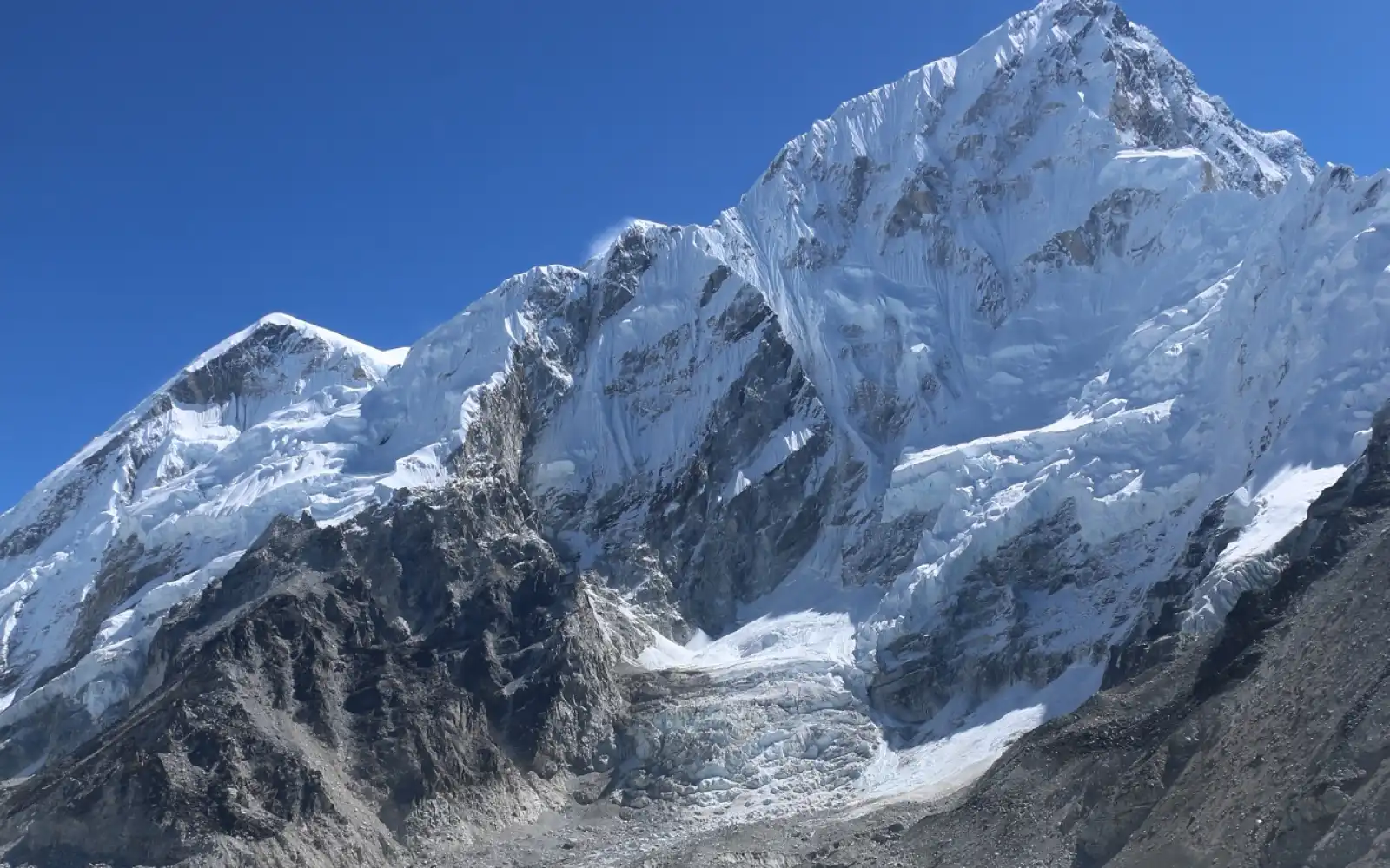
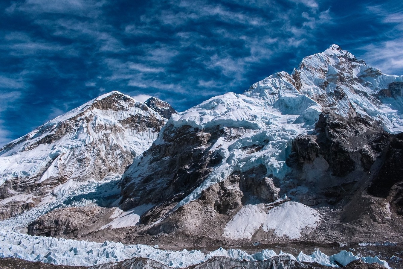
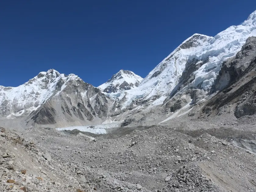
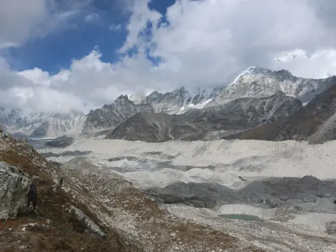
Actually, the Everest Base Camp Trek pulls in adventurers from all over the globe. There’s just something about those jaw-dropping views of Mount Everest, towering at 8,848 meters, that gets people hooked. But it’s not just the scenery—walking through the Khumbu Valley, you get a real taste of Sherpa culture. The journey kicks off in Lukla, sitting at 2,846 meters, and winds all the way up to Everest Base Camp at 5,364 meters. On the way, you’ll make your way through Sagarmatha National Park, passing legends like Lhotse and Ama Dablam.
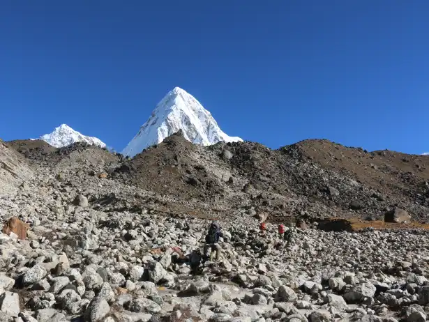
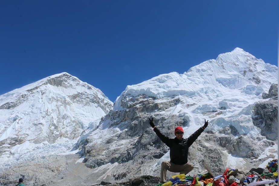
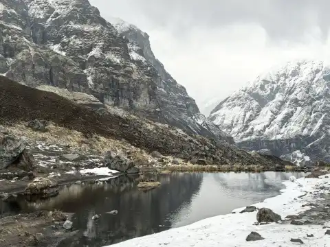
Make no mistake; the altitude of Everest Base Camp (5364m) is tough. Every step tests your grit, but the reward? Panoramas you’ll never forget. Acclimatization is key—nobody wants to deal with altitude sickness, so you take it slow. Guides help you pick your way through rocky trails, and teahouses dot the route, offering a chance to rest and eat homemade meals. It’s a blend of adventure and culture, all rolled into one. Most folks finish the round trip in about 12 to 18 days, walking close to 130 kilometers. There’s something about this trek—it pushes you, connects you to wild nature, and in the end, you come away changed.
In fact, people don’t just show up on a whim. They train hard, building endurance and strength, and pack carefully—think warm clothes, sturdy boots, all the basics. Just getting to Lukla by plane is an adventure, sometimes a little nerve-wracking. From there, trails climb up to Namche Bazaar, a lively market town at 3,440 meters. Trekkers hang out here for a couple days to get used to the altitude. Next stop: Tengboche Monastery at 3,860 meters, where monks chant in old stone halls. The path just keeps climbing—Dingboche at 4,410 meters, with the views getting sharper and more dramatic. Kala Patthar, at 5,645 meters, is where you catch the best view of Everest.
Likewise, Base Camp is a hive of activity, full of colorful expedition tents. Porters balance heavy loads like it’s nothing, and yaks shuffle across narrow bridges with supplies. The weather in the Himalayas? Unpredictable. One minute it’s sunny, the next you’re swallowed by fog. Still, trekkers bond over the challenge, swapping stories and sharing the struggle. This trek really has it all—history, nature, and a real sense of accomplishment. It never goes out of style.
Key Locations and Elevations on the Trek:
Location
Elevation (meters)
Description
Lukla
2,846
Starting point with airport; gateway to Khumbu.
Namche Bazaar
3,440
Bustling Sherpa hub; acclimatization spot with markets.
Tengboche
3,860
Monastery site; spiritual stop with Everest views.
Dingboche
4,410
Village for rest; higher altitude adjustment.
Gorak Shep
5,164
Last lodge before Base Camp; cold and windy.
Everest Base Camp
5,364
Expedition base; iconic rock marker.
Kala Patthar
5,645
Summit viewpoint; panoramic Everest sight.
Trekkers face moderate to challenging difficulty levels:
Daily hikes last 5 to 8 hours, and porters assist with gear.
Best seasons include March to May or September to November.
Costs range from $1,000 to $2,500, covering permits and guides.
Altitude sickness risks require diamox medication and slow pace.
Sherpa guides share local legends, and teahouses serve dal bhat meals.
Major Peaks Visible During the Trek:
Peak
Elevation (meters)
Notable Feature
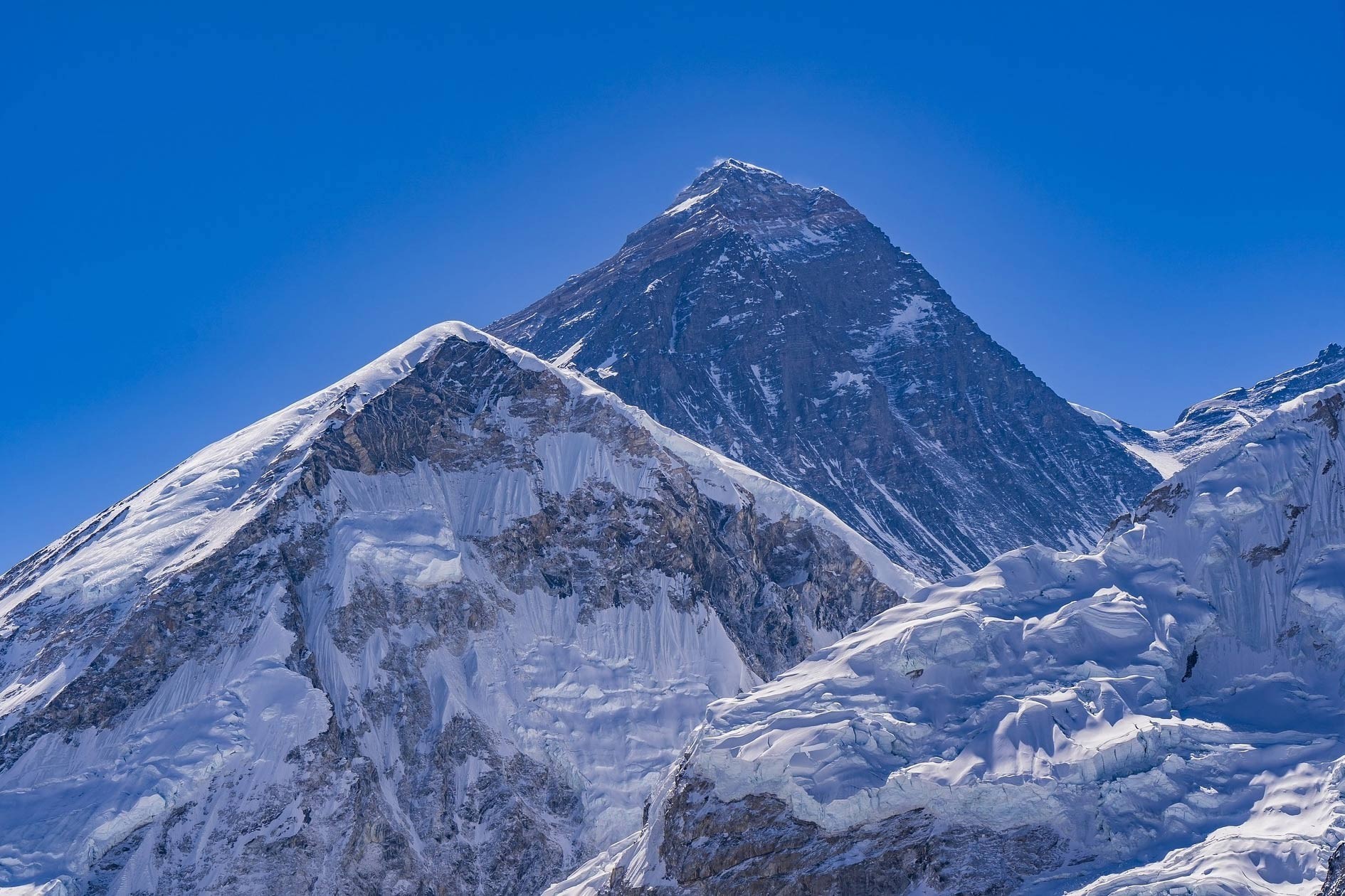
Mount Everest
8,848
World's highest; symbolic goal.
Lhotse
8,516
Fourth highest; sharp face.
Nuptse
7,861
Ridge companion to Everest.
Ama Dablam
6,812
Jewel-like shape; photogenic.
Thamserku
6,623
Snowy sentinel over valleys.
Biodiversity thrives in Sagarmatha Park, and rhododendrons bloom in spring.
Helicopters offer rescue options, but prevention beats cure.
Cultural etiquette demands respect for monasteries, so visitors remove hats indoors.
Early Expeditions: The First Attempts to Conquer Everest from 1921 to 1952
Actually, early expeditions aimed at Mount Everest (8,848m) with great ambition. British teams led the efforts from Tibet's north side. They faced severe weather and unfamiliar terrain. The 1921 reconnaissance mapped routes in detail. Climbers like George Mallory explored the Rongbuk Glacier (5,180m). They marked the North Col (7,020m) as crucial. However, political barriers limited access. Over the years, expeditions developed skills. They tested oxygen gear at high camps. Avalanches posed constant dangers. Teams included surveyors and doctors. They also documented plants and rocks. This era created global interest in Everest. Failures provided valuable lessons for future success. Overall, these attempts laid the groundwork for triumph.
Likewise, later efforts grew more intense in the 1920s and 1930s. The 1922 team reached 8,320m but faced tragedy. Seven porters died in an avalanche. Mallory returned in 1924 with Andrew Irvine. They disappeared near the summit. Debates continue over whether they reached the top first. In 1933 and 1936, teams faced storms. Climbers like Eric Shipton searched for other routes. By 1950, Nepal opened the southern route. The 1951 reconnaissance discovered the Khumbu Icefall (5,486m). Swiss teams in 1952 came close to summiting at 8,595m. Oxygen and weather conditions held them back. These challenges refined techniques. International cooperation increased. Expeditions shifted focus from exploration to conquest. The determination of this period inspired modern mountaineering.
Timeline of Key Early Expeditions:
Year
Expedition Details
Highest Point Reached (meters) | Outcome
1921
British reconnaissance led by Howard-Bury; mapped north approach.
7,000 (North Col) | Identified viable route; no summit attempt.
1922
First full attempt; used oxygen; avalanche killed 7.
8,320 | Record height but tragic loss.
1924
Mallory and Irvine disappeared; oxygen improved.
8,600 (estimated) | Mystery remains; body found later.
1933
British team faced winds; led by Ruttledge.
8,570 | Weather forced retreat.
1935-1936
Recon and attempts; Shipton involved.
7,800 | Gathered data; no high success.
1938
Tilman led; light-style expedition.
8,300 | Storms stopped progress.
1951
British south-side recon; found Western Cwm.
6,400 | Opened Nepal route.
1952
Swiss attempts; Tenzing Norgay guided.
8,595 | Closest pre-summit effort.
Expeditions used yaks for transport, and porters carried loads up to camps.
Political permissions from Tibet delayed starts, but enthusiasm persisted.
Gear evolved from wool to early synthetics, and tents withstood blizzards.
Medical knowledge grew; doctors treated frostbite effectively.
Challenges Faced by Early Climbers:
Challenge
Description
Impact
Altitude
Thin air caused hypoxia.
Limited climbs without oxygen.
Weather
Monsoons and winds raged.
Forced many retreats.
Terrain
Icefalls and crevasses endangered lives.
Required rope teams.
Logistics
Long approaches from Darjeeling.
Exhausted teams early.
International teams included Indians and Tibetans, so diversity aided success.
Failures built resilience, and media coverage fueled public fascination.
The Historic Breakthrough: Hillary and Tenzing's 1953 Summit and the Birth of South Base Camp
Actually, Edmund Hillary and Tenzing Norgay achieved a remarkable feat in 1953. They reached the summit of Mount Everest (8,848m) on May 29 at 11:30 a.m. The British expedition, led by John Hunt, chose the south route from Nepal. Teams built camps progressively higher. Base Camp sat at 5,364m in the Khumbu Valley. Climbers tackled the Khumbu Icefall (5,486m) and the Western Cwm. They managed to reach the South Col (7,920m) despite strong winds. Hillary and Tenzing used their oxygen gear effectively. They overcame the Hillary Step near the summit. Their success marked the birth of South Base Camp as a key hub. It inspired future climbs around the world. This breakthrough united global mountaineering efforts and highlighted Sherpa contributions as well.
In fact, the duo's climb transformed Everest exploration forever. They began from Camp IX at 8,500m early in the morning. Hillary led through snow and rock while Tenzing followed closely behind with expert skill. They faced thin air and steep drops. Yet, their perseverance drove them onward. At the top, they planted flags and took photos. The descent brought relief and celebration. News reached Britain on coronation day. Queen Elizabeth II knighted Hillary soon after. South Base Camp (5,364m) became the standard entry point in Nepal. It gradually boosted tourism in Khumbu. Sherpas gained recognition as vital partners in these efforts. This event also sparked humanitarian work by Hillary. Overall, the summit gave rise to the modern legacy of Everest.
Everest Base Camp Trek with Helicopter Fly Out 10 Days | 10 days
From Remote Path to Trekking Trail: How Lukla Airport in 1964 Transformed Access to the Khumbu Region
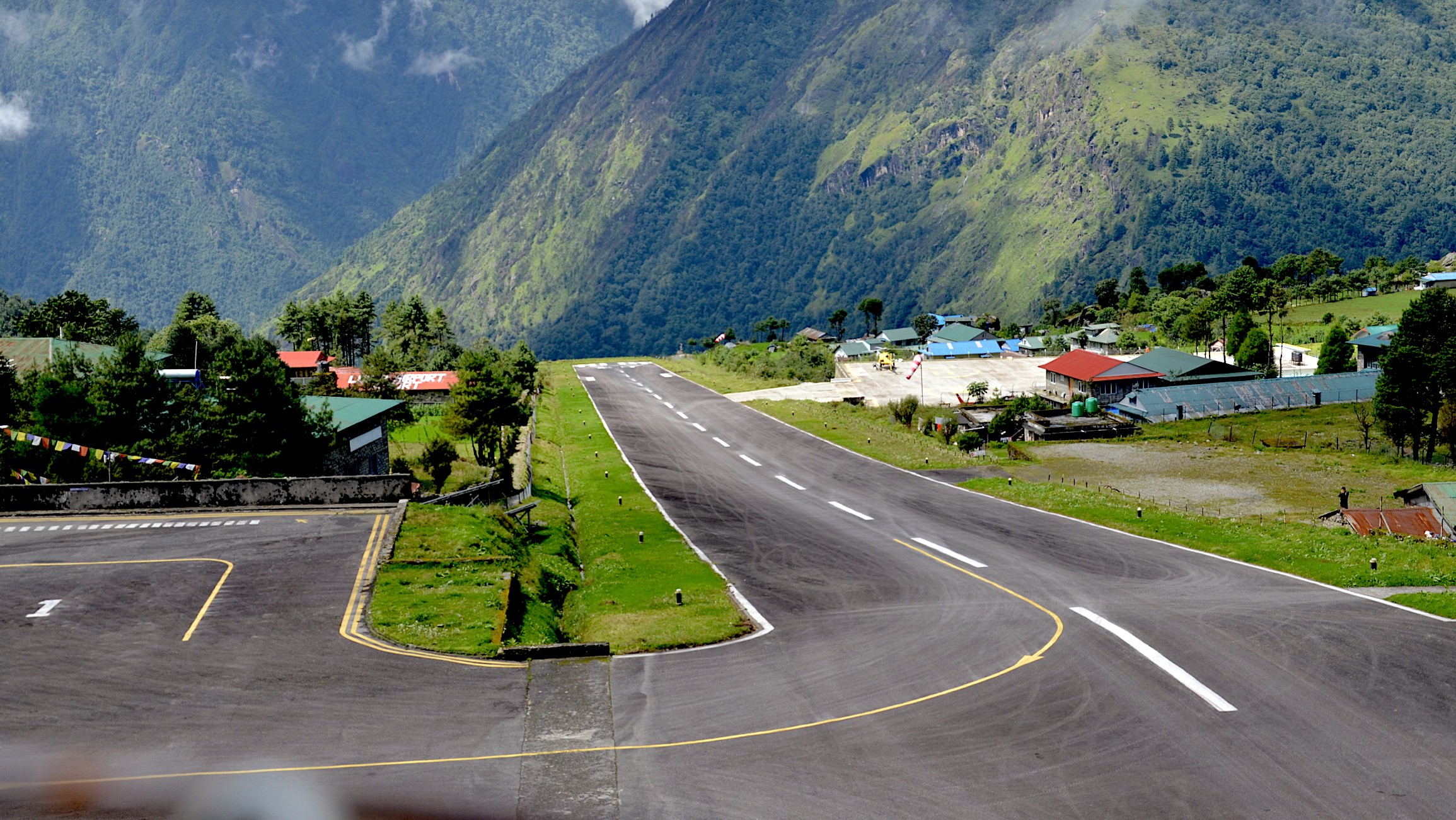
Actually, Lukla Airport changed everything for Khumbu when it opened in 1964. Built under Sir Edmund Hillary’s watch, the project began after he purchased land from Sherpa families for 2,650 dollars. Without machines, villagers shaped the runway themselves using only basic tools. Their effort carved a path into thin mountain air. Nothing mechanical helped back then. At 527 meters, the strip stretched across tight terrain. Up it rose - 2,845 meters high into a squeezed passage between hills. Getting there used to mean walking from Jiri, seven full days on foot.
Likewise, now air travel shrinks that stretch down to half an hour when flying out of Kathmandu. Fast deliveries reached mountain villages first. Because of better access, tourism grew near Everest's peak at 8,848 meters. Local businesses gained strength from the shift. Climbers found gear and planning simpler over time. Though small, the new airport connected faraway trails to distant places.
Out near Everest, change came fast. At first, loads traveled on people's backs. Locals stomped earth into firm ground through rhythm and movement. A proper strip of pavement arrived by 2001, built to keep landings steady. By 2008, it wore a new name - honoring two pioneers. These days, planes arrive every year carrying fifty thousand travelers. Places to rest and eat sprouted thick along the paths up high. Now reaching Namche Bazaar at 3,440 meters happens faster. Trekking toward Everest Base Camp - sitting high at 5,364 meters - grew common. Storms still pause flights more than once. Rescue missions began using helicopters when skies clear. Change arrived slowly, yet kept traditions standing. His idea - to support Sherpa life - finally took root.
Development Timeline of Lukla Airport:
Year
Milestone
Impact
1964
Construction begins
Hand-built airstrip; initial flights start.
1965
Official opening
Connects Khumbu to Kathmandu.
1971
Regular operations
Boosts tourism and supplies.
2001
Runway paved
Improves safety amid growth.
2008
Renamed Tenzing-Hillary
Honors summit pioneers.
Built without roads; materials portered in.
Short runway ends at 600m drop-off.
Serves as gateway for EBC treks.
Weather closures common in monsoon.
Transformation Effects on Khumbu Region
Aspect
Pre-1964
Post-1964
Access Time
7-day trek from Jiri
30-min flight to Lukla (2,845m).
Visitor Numbers
Few expeditions
Over 40,000 annually.
Economy
Subsistence farming
Tourism-driven; jobs in guiding.
Supplies
Porter-dependent
Air cargo for essentials.
Reduced isolation for Sherpa villages.
Enabled schools and hospitals via Hillary's Trust.
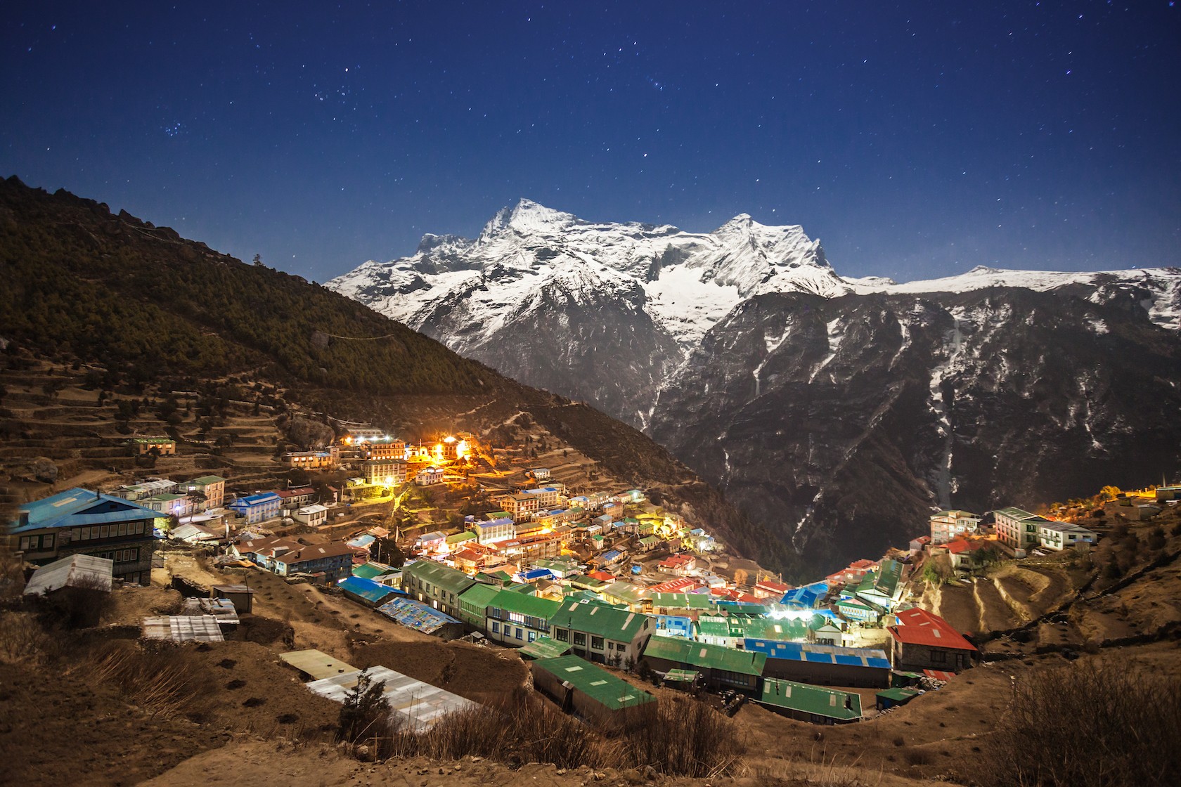
The Rise of Adventure Tourism in Everest Region: Initial Trekkers in the 1970s and the Growth of Sherpa-Guided Routes
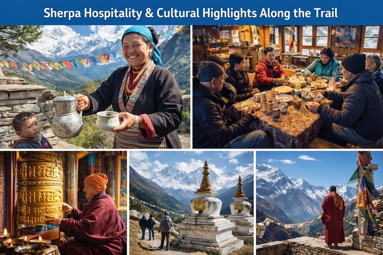
Actually, adventure tourism really took off in the Khumbu region in the 1970s. Word got out about Everest, and soon people from all over wanted to see Base Camp for themselves—5,364 meters up. Trekkers started pouring in, and most of them kicked things off from Lukla at 2,846 meters. Sherpas led the way, guiding those first waves of visitors with a mix of skill and local know-how. They didn’t just show trekkers the trails; they shared stories, culture, and a sense of what life in the Himalayas was really like. By 1973, companies like Adventure were already running organized trips, and by 1978, you could find groups of trekkers hanging out with climbers at Base Camp—32 that year alone. The old expedition routes started turning into well-trodden tourist paths, all thanks to the Everest hype in the media. This wasn’t just a fleeting trend; it sparked a real boom in trekking and gave the local economy a solid boost. Honestly, the 1970s lit a fire under global wanderlust for the Himalayas.
Actually, Sherpa-guided routes grew fast around this time. Locals took their mountaineering know-how and turned it toward tourism. They led trekkers from Namche Bazaar—3,440 meters up—and on to the higher villages. People got their first taste of Sherpa hospitality in those cozy teahouses along the way. Sagarmatha National Park opened in 1976, aiming to protect the area as visitor numbers climbed. Guided tours kept people safe at altitude, and by the end of the decade, the number of annual visitors had shot up. Sherpas weren’t just porters anymore; they became real leaders in this new world of adventure travel. The whole thing sparked a mix of cultural exchange—traditions held strong, but the community also adapted to change. In the end, Sherpas laid the groundwork for what modern trekking looks like today.
Key Milestones in 1970s Trekking Rise:
Year
Event
Impact
1973
Adventure trek to Base Camp area
First organized tourist groups arrive.
1976
Sagarmatha Park established
Protects trails; boosts eco-tourism.
1978
Trekkers visit Messner's camp
32 visitors signal growing interest.
Late 1970s
Sherpa guides standardize routes
From Lukla (2,846m) to EBC (5,364m).
Initial trekkers often hiked from Jiri, taking weeks.
Sherpas like Tenzing Norgay inspired guiding profession.
Media from 1960s expeditions fueled 1970s tourism.
Groups focused on cultural immersion in Sherpa villages.
Growth Factors for Sherpa-Guided Routes:
Factor
Description
Contribution
Airport Access
Lukla (2,846m) shortened journeys
Enabled quick starts; increased visitors.
Sherpa Expertise
High-altitude knowledge
Ensured safe navigation to Dingboche (4,410m).
Economic Shift
From farming to guiding
Created jobs; sustained communities.
Global Appeal
Post-1953 summit hype
Drew adventurers worldwide.
By 1979, park became UNESCO site, enhancing prestige.
Trekkers bonded with guides over local legends.
Routes included stops at Tengboche Monastery (3,860m).
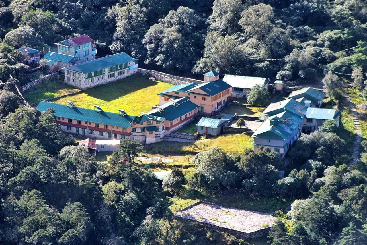
Building the Legacy: Early Infrastructure, Teahouses, and the Trail's Development Through the Decades
Before roads came, paths through Khumbu grew slowly over time. By 1963, a road arrived in Jiri, making travel less difficult. Then, in 1964, an airstrip began operating at Lukla - high up near 2,846 meters. That changed how people moved across the region. Places to rest started long ago where merchants once paused. Locals known as Sherpas offered basic shelter to those passing through. Mountains saw more footprints after 1953. Rivers gave way fast when bridges appeared over Dudh Koshi. Visitors grew thanks to first steps laid long ago. Places such as Namche (3,440m) linked into wider trails. Distance faded once paths met bold moves.
Here, decades passed. Paths kept growing along with small tea spots. During the 1970s, more visitors arrived - lodges sprouted one after another. The next decade showed a different picture: garbage became hard to ignore, so people started picking it up. When planes needed safer landings, Lukla's strip got paved around 2000. Now, sunlight runs lights; warmth stays inside newer rooms. Paths were shifted around to slow down trail wear. Since 2018, permit income has gone toward community work nearby. Slow changes have made high climbs feel easier. Nature stays protected along the way. All these years of tweaks keep the tradition alive.
Timeline of Infrastructure Development:
Decade
Key Changes
Examples
1960s
Access improvements
Jiri road (1963); Lukla Airport (2,846m, 1964).
1970s
Teahouse growth
Family-run lodges along trails to EBC (5,364m).
1980s-1990s
Maintenance focus
Bridge reinforcements; trash management.
2000s
Modern upgrades
Runway paving; better dining halls.
2010s-2020s
Sustainable tech
Solar energy; Khumbu permit for projects.
Teahouses trace to centuries-old trade routes.
Hillary Bridge near Namche (3,440m) reinforced recently.
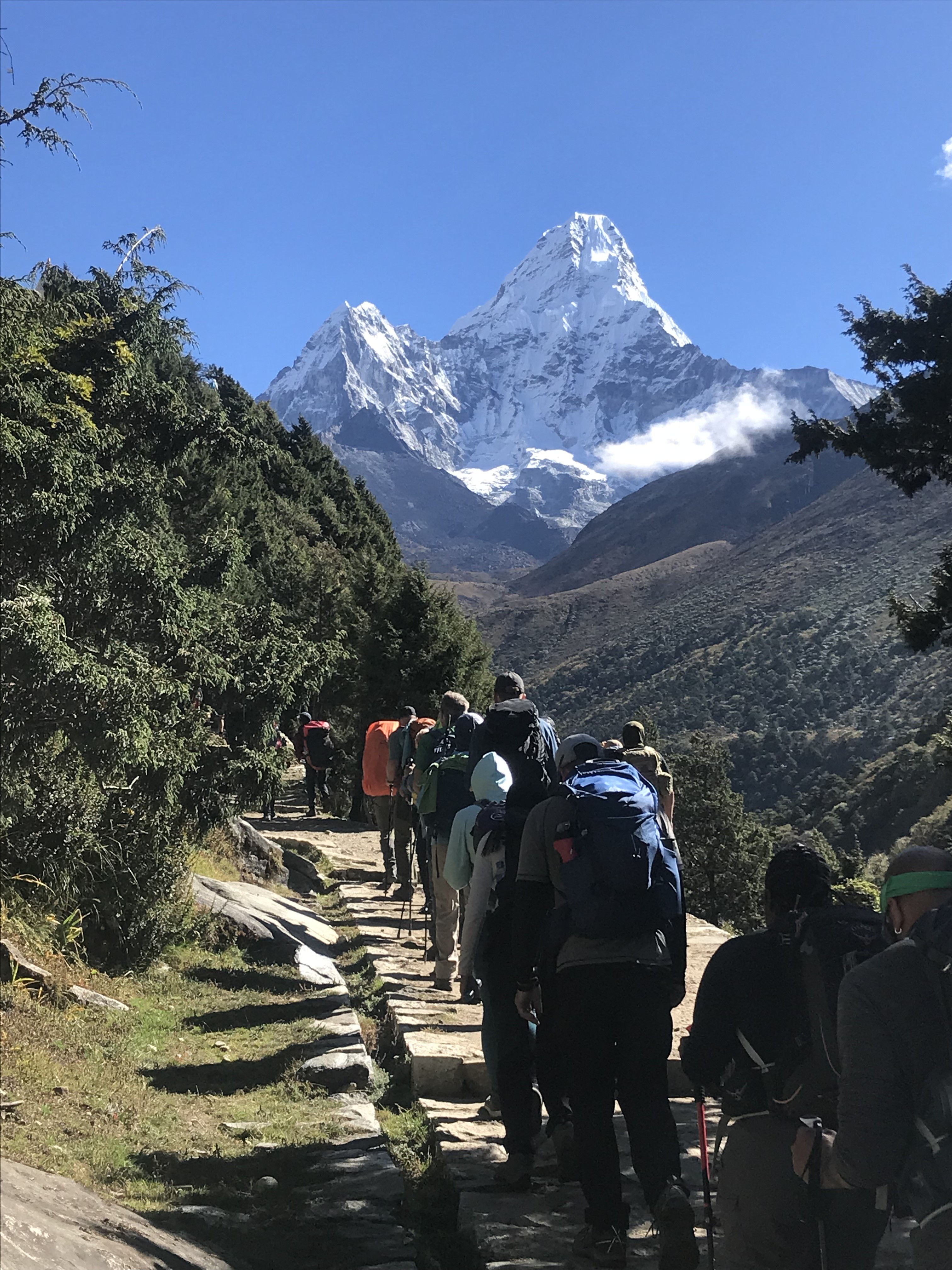
Today's Trail Experience: A Popular Route Attracting 40,000 Trekkers Annually from Lukla to EBC at 5,364 Meters
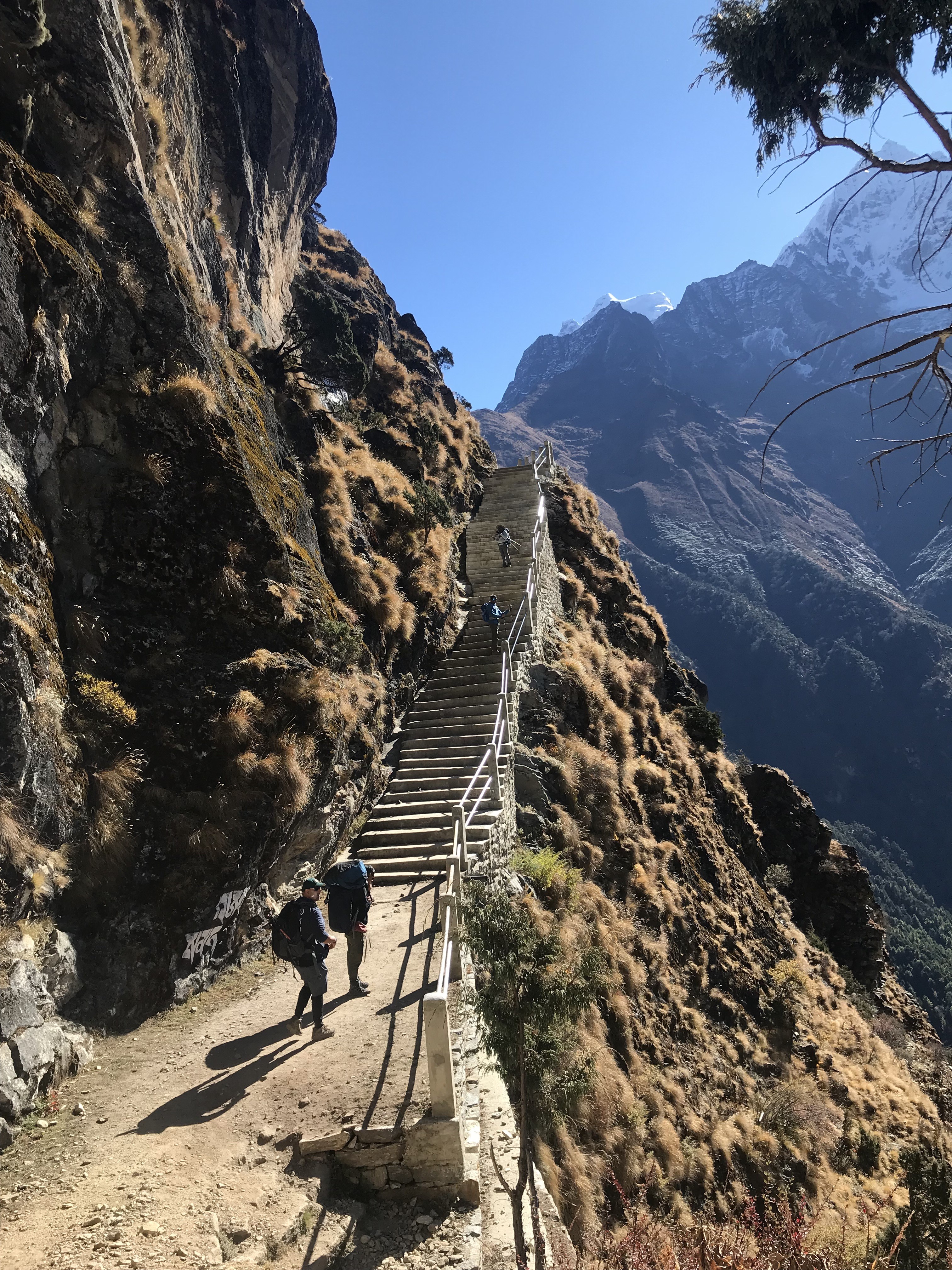
Every year, more than 40,000 trekkers head for Everest Base Camp, all chasing that bucket-list adventure. The EBC Trek route starts in Lukla, perched at 2,846 meters, and winds its way up to the base camp at a whopping 5,364 meters. From the get-go, hikers cross those wild suspension bridges you’ve probably seen in photos. There’s green valleys, thick pine forests, and the steady thrum of fellow trekkers’ boots.
Actually, Namche Bazaar sits at 3,440 meters and feels like a little mountain city—full of energy, packed with teahouses where you can grab a hot meal, hop on Wi-Fi, and catch your breath. Guides lead the way, and the trails are so well-marked it’s hard to get lost, even with the crowds. The whole trek is about 130 kilometers round trip, and every step gives you another jaw-dropping view of Everest looming in the distance.
Likewise, it’s not just a hike; it’s a blend of adventure and Sherpa culture. People come from all over the world, drawn by the mix of challenge and community. Most trekkers follow a set itinerary to keep things safe and manageable. You fly into Lukla, spend your first night in Phakding, then push on to Namche. Acclimatization days are built in, so you don’t end up with altitude sickness. The trail climbs higher, winding through Tengboche and Dingboche, then up to Gorak Shep, right before the base camp itself. There’s even a side hike up Kala Patthar for sunrise—think panoramic views you’ll never forget.
Moreover, EBC Trek in Spring and autumn are the busiest times, but honestly, there’s no bad season to go. The trek’s popularity never really fades, and it’s easy to see why. The Everest Base Camp route just keeps delivering, year after year.
Standard Daily Itinerary and Elevations (12-14 Day Trek):
Day
Route Segment | Elevation (meters)
Distance (km) | Approx. Time
Kathmandu to Lukla flight; Lukla to Phakding | 2,846 to 2,610
8 | 3-4 hours
Phakding to Namche Bazaar | 2,610 to 3,440
10-12 | 5-7 hours
Acclimatization in Namche Bazaar | 3,440
- | Rest day
Namche to Tengboche | 3,440 to 3,860
10 | 5-6 hours
Tengboche to Dingboche | 3,860 to 4,410
11 | 5-6 hours
Acclimatization in Dingboche | 4,410
- | Rest/hike
Dingboche to Lobuche | 4,410 to 4,940
10 | 5 hours
Lobuche to Gorak Shep; to EBC | 4,940 to 5,164; to 5,364
14 round | 6-8 hours
Gorak Shep to Kala Patthar; descend | 5,164 to 5,645 summit
7 round | 3-4 hours
Annual trekkers exceed 40,000 in peak recovery years.
Spring (March-May) and autumn (Sept-Nov) see highest crowds.
Permits include Sagarmatha National Park entry.
Mandatory guides since 2023 enhance safety.
Teahouses provide meals like dal bhat along the way.
Current Trekker Statistics and Trends:
Period
Estimated Annual Trekkers
Notes
Pre-2020
Average 30,000-40,000
Steady growth.
Post-Pandemic (2023+)
40,000+ (some months 10,000+)
Record surges in October.
Peak Month Example
April/May
Up to 12,000+ entries.
Helicopters offer scenic flights and rescues.
Apps track weather and health for better preparation.
The 2015 Earthquake Devastation: Avalanches at Base Camp Killing 21 and Triggering Landslides Across the Khumbu Valley
On April 25, 2015, a huge earthquake—7.8 on the Richter scale—hit Nepal. The ground shook so hard it sent avalanches tearing down Mount Everest. At South Base Camp, everything turned chaotic in seconds. Ice, rock, and wind slammed into tents, tossing people and gear everywhere. Twenty-one people died right there at camp. Dozens more got hurt, some badly, from falling debris.
Down in the Khumbu Valley, the quake set off landslides. Trails vanished under rubble. Villages and teahouses cracked, some just collapsed outright. Helicopters rushed in for rescue. Survivors scrambled to get out, even as aftershocks kept coming. For Everest, this was the deadliest disaster in its history. People saw just how wild and dangerous these mountains can be.
Then, just as things seemed to settle, another earthquake hit on May 12—this one almost as strong. More landslides, more blocked trails, especially near Phakding and Namche Bazaar. Sherpa communities got to work, rebuilding what they could. The climbing season ended early. Most climbers packed up and headed home fast. Aid came in from all over the world, but the valley was scarred—whole sections looked changed forever.
Even so, people held on the trail during Everest Base Camp Trek. They rebuilt, tougher than before, and set up better safety rules for the future. The Khumbu Valley bounced back, but nobody forgot what happened that spring.
2015 Everest Avalanche and Earthquake Key Facts:
Aspect
Details
Impact
Date
April 25, 2015 (main quake)
7.8 magnitude; triggered Pumori avalanche.
Deaths at Base Camp
21-22 (including Sherpas and climbers)
Deadliest single disaster on Everest.
Injuries
61+ at Base Camp
From wind blast and debris.
Total Nepal Deaths
9,000 nationwide
Landslides and building collapses.
Aftershock
May 12, 2015 (7.3 magnitude)
Additional avalanches; season closure.
Avalanche from Pumori (7,161m) hit Base Camp directly.
Victims included Sherpas, guides, and international climbers.
Three more deaths occurred in Khumbu Icefall later.
Helicopters evacuated hundreds trapped higher up.
Impact on Khumbu Valley Trails and Infrastructure
Location
Damage Type
Recovery Notes
Base Camp (5,364m)
Tents destroyed; avalanches
Rebuilt for following seasons.
Phakding area
Minor landslides on trails
Alternative routes engineered quickly.
Namche Bazaar (3,440m)
Some teahouses cracked
Most operational soon after.
Tengboche (3,860m)
Monastery and lodges affected
Repaired with community effort.
General Trails
Blockages and rockfalls
Cleared within weeks; passable by autumn.
Minor landslides crossed paths but locals rerouted swiftly.
Teahouses in lower valleys sustained damage yet reopened.
Immediate Aftermath: Damage to Settlements Like Namche Bazaar, Lukla, and Langtang, with Trails Blocked by Debris
Actually, the 2015 Nepal earthquake hit hard and fast. Right away, places all over the Khumbu Valley took a beating. Namche Bazaar, sitting at 3,440 meters, ended up with cracked buildings and busted teahouses. Down in Lukla, the structures mostly survived, but everything turned chaotic. Langtang didn’t get that lucky—a huge avalanche basically wiped out the whole village. Trails everywhere filled up with landslides and rubble. Rockfalls blocked the way near Phakding and even higher up. Rescue teams scrambled, but aftershocks kept shaking the ground.
In fact, people grabbed what they could and moved to safer spots as fast as possible. That first wave of damage really showed how vulnerable these remote Himalayan villages are. It threw daily life into turmoil and brought trekking to a dead stop.
Not every place suffered the same way, though. Langtang, about 3,430 meters up, just disappeared under a wall of ice and rock falling from Langtang Lirung. Hundreds lost their lives right there. Namche Bazaar had some buildings collapse, but the whole town didn’t go down. Lukla’s airport, cracks and all, kept running. Meanwhile, debris from landslides clogged up valleys and rivers.
Then, more aftershocks hit on May 12, making everything worse. Trekkers and locals ended up stranded for days with barely any way out. Helicopters got a few people to safety, but help was limited. In the end, the earthquake exposed just how shaky the region’s infrastructure really is. It left scars—on the land and in the lives of everyone who called those mountains home.
Key Settlements and Immediate Damage (April-May 2015):
Settlement
Elevation (meters)
Primary Damage | Casualties/Impact
Namche Bazaar
3,440
Cracked teahouses, minor building damage; some structures affected | Limited deaths; many evacuated temporarily.
Lukla
2,846
Minimal structural damage; airport operational but disrupted | Few injuries; flights halted due to weather/debris.
Langtang Village
3,430
Completely buried by avalanche/landslide from Langtang Lirung | 243-300 deaths (locals + trekkers); village obliterated.
Khumbu Valley Trails
Varies (2,600-5,000+)
Landslides blocked paths; debris on routes to Namche and beyond | Trails impassable; trekkers stranded.
Minor landslides crossed trails near Phakding (2,610m) and Dudh Koshi areas.
Avalanches hit Everest Base Camp (5,364m); 21 deaths reported.
Langtang saw 40 million tons of rock/ice descend rapidly.
Namche residents fled to safer terrain amid panic.
Secondary Hazards and Blockages:
Hazard
Description
Affected Areas
Landslides
Triggered by main quake and aftershocks
Khumbu trails, Langtang Valley.
Debris Blockages
Rocks/ice obstructed paths and rivers
Routes to Namche (3,440m), higher Khumbue.
Avalanches
From peaks like Pumori and Langtang Lirung
Base Camp (5,364m), Langtang (~3,430m).
Aftershocks
May 12 quake (7.3M) added destruction
Widespread, including Khumbu.
Trails required rerouting due to rockfalls.
Isolation trapped people in upper valleys for days.
Debris hampered immediate relief efforts.
Recovery and Resilience: Rapid Repairs to Paths, Rebuilding of Over 7,000 Schools, and Restoration of Trekking Infrastructure by Late 2015
After the 2015 earthquake, Nepal bounced back fast. People didn’t just wait around—they got right to work. Locals grabbed whatever tools they could find and cleared debris from the Khumbu Valley trails. Teahouse owners reopened their doors, leaning on each other for help. By the end of that year, trekkers could get back on the trails. The government and NGOs worked together, targeting schools first. More than 7,000 schools got rebuilt or repaired, so millions of kids could get back to class. That brought hope, and honestly, it brought tourists back too. There was a sense of life returning to normal.
Actually, the rebuilding didn’t slow down on the Everest Base Camp Trail. Whenever a landslide blocked a path in Khumbu, people fixed it or carved out a new route. Lukla airport got flights going again pretty quickly. Teahouses in places like Namche Bazaar kept sprucing up their rooms little by little. Across the country, people focused on making new buildings safer and stronger. Temporary classrooms popped up so kids wouldn’t miss out on school while construction crews worked. By the end of 2015, permanent schools were rising from the rubble. All of this—every cleared path and rebuilt classroom—honored those lost and pulled communities even closer together.
Rapid Trail and Trekking Infrastructure Repairs (2015):
Aspect
Timeline
Details
Trail Clearing
May-July 2015
Locals engineered alternative routes; minor landslides fixed
Teahouses Restoration
Mid-2015 onward
Most operational by autumn; some upgraded
Lukla Airport (2,846m)
Immediate post-quake
Minimal damage; flights resumed quickly
Khumbu Paths to EBC (5,364m)
By late 2015
Fully passable; better shape than pre-quake in sections
Namche Bazaar (3,440m)
Summer 2015
Damaged lodges repaired; internet restored gradually.
Monsoon season aided natural clearing in some areas.
Community labor rebuilt bridges and steps.
Tourism reopened for autumn season.
New wider paths added in places like Tengboche.
School Rebuilding Progress (Post-2015 Earthquake):
Metric
Number
Notes
Schools Damaged/Destroyed
8,000-9,000
Across 31 districts; 14 most affected
Schools Rebuilt/Repaired
Over 7,000
By late 2015 initial progress; continued to 7,700+ long-term
The 2026 Landscape: Enhanced Lodges, Sustainable Practices, and Post-Pandemic Upgrades Amid Warnings of Impending Regulations
By 2026, the Everest Base Camp trek feels different. Lodges along the trail step up their game—hot showers, better beds, and solar panels keep places warm and bright. Teahouses now have real comforts, not just the basics. You can actually get a good night’s sleep or a proper meal at the end of a tough day. After the pandemic, they didn’t just clean up; they made everything safer and easier to reach. Trails look better, too—wider, well-kept, and easier to walk.
Actually, there’s a real push to go green. Plastic waste? Way down. Lodges that put in the effort to be eco-friendly get certified. But it’s not all smooth sailing. New rules are coming, and everyone’s aware. Now, you need a guide no matter what, which keeps people safer and cuts down on crowds. The idea is to keep the whole place from getting overrun. It’s a balancing act—letting people chase adventure while making sure the Khumbu region stays beautiful for years to come.
From Lukla, things start to change fast along the Everest Base Camp Trek. In Namche Bazaar, boutique lodges combine that classic Sherpa vibe with modern perks. Up higher, rooms stay cozy thanks to electric heating. Even in the middle of nowhere, you can check your messages—Starlink internet covers some of the most remote spots. Villages pull together to collect rainwater and sort their waste. Government rules require every trekker to hire a licensed guide now, and permit fees go straight to conservation work. Warnings about stricter limits are everywhere. Trekkers get the message and pick up greener habits. So, Everest Base Camp Trek 2026 brings more comfort and a clearer sense of responsibility—progress, but with caution.
2026 Lodge and Infrastructure Upgrades:
Location
Elevation (meters)
Key Upgrades | Sustainable Features
Namche Bazaar
3,440
Boutique lodges, en-suite bathrooms, heated blankets | Solar power, eco-certification.
Dingboche
4,410
Improved insulation, hot showers | Rainwater harvesting, composting.
Climate Change Impacts: Melting Glaciers, Unstable Trails, and Rising Risks of Avalanches and Rockfalls
Actually, climate change is hitting the Everest region hard. Glaciers are melting faster every year. The Khumbu Glacier, right by Base Camp at 5,364 meters, keeps getting thinner. Trails turn sketchy—rocks get exposed, erosion chews up the path, and once-solid ground starts to crumble as permafrost thaws. Rockfalls are more common now, especially along the way to Namche Bazaar at 3,440 meters. Avalanches? Those aren’t just a winter thing anymore—they slam down even during the main trekking seasons. And the weather’s all over the place: storms arrive out of nowhere, and the old patterns just don’t hold up.
Likewise, this isn’t just tough on trekkers—it hits Sherpa communities too. Higher up, it’s warming even faster than the rest of the world. People notice. Awareness is growing, and folks are doing what they can to adapt, but the environmental problems are serious—and they’re not waiting around.
As the glaciers shrink, the whole landscape shifts. Khumbu Glacier keeps losing thickness, year after year. Ponds pool up on the surface and mess with the ice, making it less stable. Around Base Camp, crevasses keep widening. Trails from Phakding at 2,610 meters up to the higher villages take a beating from erosion. Sometimes rockfalls and landslides block the way. Avalanches don’t stick to a schedule anymore—they hit in spring and autumn, and you never really know when. Fewer days are safe for climbing now. Sherpas talk about less snow and way more heat than before, forcing everyone to rethink routes and stay alert. In short, climate change is making these legendary trails a lot riskier.
Key Climate Impacts on the Everest Region:
Impact
Description
Affected Areas/Elevation
Glacier Melt
Khumbu Glacier thinning ~1m/year; rapid loss since 1960s
Base Camp (5,364m), Khumbu Icefall (5,486m).
Unstable Trails
Exposed rock, erosion from permafrost thaw
Phakding to Namche (2,610m-3,440m), higher paths.
Rockfalls
Increased frequency from melting ice in cracks
Slopes above 4,000m, trails to Dingboche (4,410m).
Avalanches
More events in non-winter seasons
Pumori area, routes near Base Camp (5,364m).
Glaciers thin by over 100m since 1960s in some spots.
Mass loss accelerates to -0.38 mwe/year recently.
Higher altitudes (>6,000m) now show significant thinning.
Meltwater creates new lakes and instability.
Rising Hazards and Risks:
Hazard
Frequency Change
Consequences for Trekkers
Avalanches
Increasing in spring/autumn
Sudden threats on trails; evacuation needs.
Rockfalls/Landslides
More common due to thaw
Blocked paths; injury risks
Unpredictable Weather
Stronger storms, shorter stable periods
Reduced visibility; altitude sickness rise
Trail Erosion
Permafrost melt destabilizes ground
Slippery, rerouted sections
Khumbu Glacier instability prompts discussions on Base Camp relocation.
Evolving Rules After 2026 May Limit Permits Adjust Routes and Manage Tourist Numbers
After 2026, Nepal is trying to tighten its grip on Everest-area rules as it is largely too crowded every year. To handle too many climbers and trekkers, officials consider limiting permits for Everest Base Camp Trek. Instead of going alone on Everest Base Camp Trekking trail, foreign trekkers must now hire certified guides across the country. Solo trekkers by outsiders fade under these changes. Safety improves, jobs grow - a quiet win for communities. Not every path welcomes crowds these days. Some limits arrive just in time, matching footfall to nature’s pace. Rules shift quietly where thin air meets heavy traffic. Protection grows stronger when numbers stay small. Change moves slowly, yet it holds the valley together.
Likewise, trekkers have started talking about tighter rules once 2026 arrives. Money from permits goes toward fixing roads and removing waste. Instead of applying solo, climbers rely on guides who work with official groups. Some trails shift direction so popular spots get less traffic. Before setting hard numbers, officials take time to measure how many people an area can handle. Now the trails see less damage, plus trash is better managed. More work comes to local guides when climbs happen. Safety feels stronger for those walking high paths. Responsibility matters more than open entry these days. The peak stays protected - 8,848 meters of mountain and land around it.
Towards Regenerative Tourism Moving Base Camp Reducing Impact Protecting Sherpa Communities
Meanwhile, high up near Everest, Nepal is reshaping how visitors interact with fragile landscapes. Because ice beneath the old camp softens each year, officials now shift operations lower down. That spot - once solid at 5,364 meters - is no longer safe for long-term use. Instead of waiting, teams clean routes while guiding fewer people through sensitive zones. From trash pickup to smarter trails, changes unfold quietly but steadily.
Every so often, villages take charge of keeping their surroundings spotless. Because guides depend on mountain travel, rules now guard their income fairly. Some programs back guesthouses that tread lightly on nature. With care like this, traditions hold strong alongside healing forests. Over time, these methods feed resilience into daily life. Footprint on the delicate Himalayas grows smaller because of them. In turn, Everest - rising 8,848 meters - stays more protected through these efforts. Even, some projects are doing their level best to protect cultural highlights on Everest Base Camp Trail and flora and fauna in Sagarmatha National Park.
Starting in 2025, a new cleanup effort begins on Everest, lasting through 2029. Instead of staying put, Base Camp might move downhill after early tests show promise. Litter finds its way into bins more easily now, thanks to fresh drop spots along trails. Because of fair pay systems, local Sherpa families see steady benefits over time. Fewer climbers climb each season, kept low by careful tracking behind the scenes. From high valleys comes a quiet shift. Not just survival but renewal shapes life in Khumbu now.
Because of changing choices, villages stand stronger against storms that come more often. Instead of taking from the land, visitors begin to give back in small ways. Through this, old trails carry stories worth keeping. Even mountains need rest - so people adapt slowly, carefully.
Five-Year Everest Cleaning Action Plan (2025-2029) Key Elements:
Element
Description
Focus Area
Base Camp Relocation
Feasibility study for lower, stable site
Address melting Khumbu Glacier instability.
Waste Management
Reclaim fixed ropes; garbage points to Camp II
Reduce 85+ tonnes annual waste.
Climber Limits
Based on carrying capacity
Prevent overcrowding; lower environmental strain.
Conservation Fee
Convert $4,000 deposit to permanent
Fund ongoing cleanup and monitoring.
Mountain Rangers
Monitor waste and compliance
Enforce rules at high elevations.
Plan tackles exposed trash from melting ice.
Urine diversion and eco-toilets reduce pollution.
Sherpa-led initiatives support community involvement.
Initiatives to Reduce Footprint and Preserve Sherpas:
Initiative
Details
Benefits
Waste Reduction
Carry-out policies; recycling programs
Cleaner trails to Gorak Shep (5,164m).
Sustainable Lodges
Solar power; low-impact designs
Lower energy use in teahouses.
Community Revenue
Permit fees fund local projects
Economic stability for Sherpas.
Cultural Preservation
Education on traditions; fair wages
Maintain Sherpa identity amid tourism.
Rerouting Trails
Avoid erosion-prone areas
Protect fragile permafrost zones.
Regenerative tourism emphasizes "leave no trace" ethics.
Reflecting on the Trek's Timeless Appeal: Balancing Adventure, Heritage, and Adaptation for Generations to Come
Here, high above sea level, the path to Everest Base Camp pulls people young and old. Reaching 5,364 meters isn’t just a number - it becomes real under steady boots. There, Mount Everest rises, massive at 8,848 meters, unmoving in the thin air. Along the way, Sherpas share quiet strength through tea, stories, and centuries-old temples tucked into stone. Steel cables hum beneath feet on swaying bridges, while pink blooms light up thickets of rhododendron.
Further, stories drift up from teahouse hearths where voices gather. Though the path demands strength, still it offers deep calm. Nature shows its force here, unfiltered by distance or time. Even as things shift, the trail keeps calling. Growth happens quietly, while understanding spreads beyond borders. Stillness matters just as much as motion here. Walking through these mountains asks questions about where people truly belong.
Down the mountain, kids not yet born will walk this famous path. Because weather changes, paths and shelters adapt slowly, carefully. Nature stays safe when choices are gentle, deliberate. While new things arrive, Sherpa ways remain strong through quiet resilience. A single traveler’s choice can shift how whole communities gain from visits. Rules keep crowds at levels nature and towns can handle. Teaching people small actions adds up to big change over time. Sharing stories across cultures builds quiet respect.
As EBC Trek paths wear and weather shifts, old ways stay part of each journey. Strength comes not from reaching summits but moving forward when hard. Humility grows where voices listen more than they speak. Facing change protects what matters most down the road. In the end, the path forward stands as proof of balance - people moving with peaks, not against.
Timeless Elements of the Everest Base Camp Trek’s Appeal:
Element
Description
Enduring Value
Natural Majesty
Views of Everest (8,848m), Lhotse (8,516m), Ama Dablam (6,812m)
Inspires awe and humility
Sherpa Heritage
Monasteries like Tengboche (3,860m), local legends, hospitality
Cultural depth and connection
Physical Challenge
Ascent from Lukla (2,846m) to Base Camp (5,364m)
Personal achievement and growth
Community Spirit
Teahouses, shared meals, guide-trekker bonds
Human connection in remote settings
Spiritual Dimension
Prayer flags, Buddhist sites, reflection at high altitudes
Inner peace and perspective
The trek symbolizes human perseverance against nature’s grandeur.
Sherpa stories and songs enrich every journey.
Sunrise from Kala Patthar (5,645m) remains a universal highlight.
Generations share photos and memories of the same iconic views.
1. What is the Everest Base Camp Trek-Past, Present and Future package about? The Everest Base Camp Trek-Past, Present and Future package is about the Everest Base Camp Trek. This package explores the Everest Base Camp Trek from expeditions in 1921 to the 1953 Hillary-Tenzing summit and modern trails. It covers Lukla Airport’s impact, teahouse development, 2015 earthquake recovery and future sustainable practices for the journey to 5,364 meters. 2. When did the first attempts to reach Everest Base Camp begin? The first attempts to reach Everest Base Camp started in 1921. People wanted to conquer Everest. The 1953 Hillary and Tenzing summit from South Base Camp marked a big breakthrough. This package details the transition from paths to popular trekking routes in the Khumbu region. 3. How did Lukla Airport change the Everest Base Camp Trek? Lukla Airport was built in 1964. It changed the way people accessed the Khumbu region. The airport made it easier for people to get to the Everest Base Camp Trek. Now thousands of trekkers can reach Everest Base Camp every year. They can start their journey from Lukla. Go all the way to Everest Base Camp at 5,364 meters. 4. What role did Sherpas play in the rise of Everest Base Camp trekking? Sherpas played a role in the rise of Everest Base Camp trekking. They helped build the legacy of the Everest Base Camp Trek. Sherpa-guided routes became popular in the 1970s. This package highlights how Sherpas built the infrastructure and teahouses. They supported the growth of adventure tourism in the Everest region. 5. How many trekkers visit Everest Base Camp every year? Today around 40,000 trekkers visit Everest Base Camp every year. The popular route from Lukla to Everest Base Camp at 5,364 meters is an experience. Trekkers can enjoy the altitude and the beautiful scenery. They are supported by lodges and sustainable practices. 6. What happened to Everest Base Camp during the 2015 earthquake? The 2015 earthquake was very bad. It triggered avalanches at Everest Base Camp. Killed 21 people. The earthquake also caused landslides across the Khumbu Valley. It damaged Namche Bazaar, Lukla and the trails. People worked hard to recover quickly. They restored the trekking infrastructure by 2015. 7. How did the Khumbu region recover after the 2015 earthquake? After the 2015 earthquake people worked hard to recover. They quickly repaired the paths. Rebuilt over 7,000 schools. They restored settlements like Namche Bazaar and Lukla. This allowed the Everest Base Camp Trek to resume with resilience and infrastructure. 8. What changes can trekkers expect in the 2026 Everest Base Camp Trek? In 2026 the Everest Base Camp Trek will have some changes. There will be lodges and more sustainable practices. There may be regulations to limit permits and manage tourist numbers. This is to make sure that trekking to Everest Base Camp is responsible and safe. 9. How is climate change affecting the Everest Base Camp Trek? Climate change is affecting the Everest Base Camp Trek. The glaciers are. The trails are becoming unstable. There is a risk of avalanches and rockfalls. This package discusses ways to adapt to these changes. It wants to preserve the beauty of the journey to 5,364 meters Everest Base Camp. 10. Will there be new rules for Everest Base Camp Trek after 2026? Yes, there will be rules for the Everest Base Camp Trek after 2026. The rules may limit permits. Adjust routes. They want to manage the number of tourists and reduce the impact on the environment and the Sherpa communities. 11. What is regenerative tourism in the context of Everest Base Camp? Regenerative tourism is a way to make tourism better. It wants to reduce the impact on the environment and protect the Sherpa communities. It balances adventure, heritage and sustainability for generations on the Everest Base Camp Trek. 12. Is the Everest Base Camp Trek suitable for beginners? The Everest Base Camp Trek can be challenging. It is achievable with proper preparation. This package covers the history of the trek the trail conditions and future sustainable practices. It helps beginners to have an enjoyable journey. 13. What infrastructure developments support the Everest Base Camp Trek today? Today the Everest Base Camp Trek has infrastructure. There are teahouses and enhanced lodges. The trails have been restored after the 2015 earthquake. This package highlights the decades of development that support 40,000 trekkers. 14. How long does the Everest Base Camp Trek take? The classic route from Lukla to Everest Base Camp and usually takes 12-14 days. This package combines insights with present trail experience and future sustainable adaptations. 15. What makes this Everest Base Camp Trek package unique? This package is unique because it combines the past, present and future of the Everest Base Camp Trek. It covers the expeditions from 1921 to 1953 the present popularity with 40,000 trekkers and the future challenges like climate change and regulations. 16. How safe is trekking to Everest Base Camp in 2026? Trekking to Everest Base Camp in 2026 will be safer with infrastructure and sustainable practices. Climate change brings new risks. The package emphasizes the importance of preparation, responsible tourism and adaptation for the journey to 5,364 meters. 17. What is the altitude of Everest Base Camp? Everest Base Camp is at 5,364 meters. The trek from Lukla offers a climb through the Khumbu region. Trekkers can acclimatize to the altitude with the help of teahouses and Sherpa communities. 18. Who were the first people to summit Everest from Base Camp? The first people to summit Everest from Base Camp were Sir Edmund Hillary and Tenzing Norgay. They achieved the 1953 summit. This package celebrates their breakthrough and the birth of South Base Camp as a trekking milestone. 19. How does the package address sustainability on the Everest Base Camp Trek? The package discusses practices and post-2026 regulations. It talks about tourism and efforts to protect the Sherpa communities and the environment. It wants to address the challenges of climate change on the Everest Base Camp Trek. 20. Why should I choose the Everest Base Camp Trek-Past, Present and Future package? You should choose the Everest Base Camp Trek-Past, Present and Future package because it is a journey. It blends the history of the Everest Base Camp Trek, the current trail experience and forward-looking insights on sustainability. It is ideal for an adventure, to 5,364 meters Everest Base Camp.