[{"name":"Everest Base Camp Helicopter Tour","duration":"1","image_url":"https:\/\/www.havenholidaysnepal.com\/storage\/trip-galleries\/1\/thumb_6cd53005d75a86e373d31419d1b14d78.webp","offer_price":1195,"url":"https:\/\/www.havenholidaysnepal.com\/trips\/everest-base-camp-helicopter-tour"},{"name":"Everest Mountain Flight","duration":"1","image_url":"https:\/\/www.havenholidaysnepal.com\/storage\/trip-galleries\/4\/thumb_3b0b4f1d6f72b0ad224daf4752f2c6e0.jpg","offer_price":285,"url":"https:\/\/www.havenholidaysnepal.com\/trips\/everest-mountain-flight"},{"name":"Everest Short Trek","duration":"9","image_url":"https:\/\/www.havenholidaysnepal.com\/storage\/trip-galleries\/5\/thumb_BXPP3621.JPEG0.02033800 1727957098.webp","offer_price":895,"url":"https:\/\/www.havenholidaysnepal.com\/trips\/everest-short-trek"},{"name":"Gokyo Valley Trek","duration":"12","image_url":"https:\/\/www.havenholidaysnepal.com\/storage\/trip-galleries\/6\/thumb_10bc469b14731f23d3ce84a7092ad53f.jpg","offer_price":1195,"url":"https:\/\/www.havenholidaysnepal.com\/trips\/gokyo-valley-trek"},{"name":"15 days Annapurna Base Camp Trek","duration":"15","image_url":"https:\/\/www.havenholidaysnepal.com\/storage\/trip-galleries\/7\/thumb_87d1533bc45faf070990aef0579e4be4.jpg0.81855100 1728285496.webp","offer_price":785,"url":"https:\/\/www.havenholidaysnepal.com\/trips\/15-days-annapurna-base-camp-trek"},{"name":"Nepal Pilgrimage Tour","duration":"14","image_url":"https:\/\/www.havenholidaysnepal.com\/storage\/trip-galleries\/8\/thumb_02c3bcf2ad2e8a4c1703e90ae747b5f1.jpg","offer_price":1475,"url":"https:\/\/www.havenholidaysnepal.com\/trips\/nepal-pilgrimage-tour"},{"name":"UNESCO World Heritage Site Tour","duration":"10","image_url":"https:\/\/www.havenholidaysnepal.com\/storage\/trip-galleries\/9\/thumb_unesco-world-heritage-site-Lumbani-temple-buddhists-hindus-kathmandu-nepal0.36988600 17347617740.93089500 1737469667.webp","offer_price":715,"url":"https:\/\/www.havenholidaysnepal.com\/trips\/unesco-world-heritage-site-tour"},{"name":"Island Peak Climbing","duration":"16","image_url":"https:\/\/www.havenholidaysnepal.com\/storage\/trip-galleries\/11\/thumb_Island peak0.53947000 1734692503.webp","offer_price":2495,"url":"https:\/\/www.havenholidaysnepal.com\/trips\/island-peak-climbing"},{"name":"Upper Mustang Trek","duration":"18","image_url":"https:\/\/www.havenholidaysnepal.com\/storage\/trip-galleries\/12\/thumb_upper mustang 7 Oct-2024.jpg0.95398900 1728286166.webp","offer_price":2995,"url":"https:\/\/www.havenholidaysnepal.com\/trips\/upper-mustang-trek"},{"name":"Annapurna Circuit Trek","duration":"16","image_url":"https:\/\/www.havenholidaysnepal.com\/storage\/trip-galleries\/15\/thumb_tibetan-flags.jpg0.04843900 1728289138.webp","offer_price":985,"url":"https:\/\/www.havenholidaysnepal.com\/trips\/annapurna-circuit-trek"},{"name":"Gosainkunda Lake Trek","duration":"10","image_url":"https:\/\/www.havenholidaysnepal.com\/storage\/trip-galleries\/16\/thumb_5A8083B3-C007-41A8-853F-D0C37C97D235_1_105_c.jpeg0.52581200 1731845258.webp","offer_price":595,"url":"https:\/\/www.havenholidaysnepal.com\/trips\/gosainkunda-lake-trek"},{"name":"Zip-lining in Pokhara and Dhulikhel","duration":"1","image_url":"https:\/\/www.havenholidaysnepal.com\/storage\/trip-galleries\/18\/thumb_215f765e2ebc995dd5c800b4bfdbacc3.jpg","offer_price":82,"url":"https:\/\/www.havenholidaysnepal.com\/trips\/zip-lining-in-pokhara-and-dhulikhel"},{"name":"Annapurna Heli Tour","duration":"1","image_url":"https:\/\/www.havenholidaysnepal.com\/storage\/trip-galleries\/19\/thumb_d71a6bbb9fd4da8d1b567a5cdbdec85d.jpg","offer_price":555,"url":"https:\/\/www.havenholidaysnepal.com\/trips\/annapurna-heli-tour"},{"name":"Paragliding in Pokhara","duration":"1","image_url":"https:\/\/www.havenholidaysnepal.com\/storage\/trip-galleries\/20\/thumb_de788d2dd9726783431f882c007efae1.jpg","offer_price":65,"url":"https:\/\/www.havenholidaysnepal.com\/trips\/paragliding-in-pokhara"},{"name":"Ultra-Flight in Pokhara","duration":"1","image_url":"https:\/\/www.havenholidaysnepal.com\/storage\/trip-galleries\/21\/thumb_e27a9fb572a5c21611bb2a3c18e4b8f0.jpeg","offer_price":175,"url":"https:\/\/www.havenholidaysnepal.com\/trips\/ultra-flight-in-pokhara"},{"name":"Sarangkot Hiking","duration":"1","image_url":"https:\/\/www.havenholidaysnepal.com\/storage\/trip-galleries\/22\/thumb_100ef822fea19987166c6c1366215f15.jpg","offer_price":55,"url":"https:\/\/www.havenholidaysnepal.com\/trips\/sarangkot-hiking"},{"name":"Mera Peak Climbing","duration":"18","image_url":"https:\/\/www.havenholidaysnepal.com\/storage\/trip-galleries\/24\/thumb_d16ae3895f678cf26ffbf2455f541fb5.jpg0.31883400 1732617790.webp","offer_price":2475,"url":"https:\/\/www.havenholidaysnepal.com\/trips\/mera-peak-climbing"},{"name":"Lower Dolpo Trek","duration":"18","image_url":"https:\/\/www.havenholidaysnepal.com\/storage\/trip-galleries\/26\/thumb_Dolpo Galary - 1.JPG0.37725200 1727939952.webp","offer_price":2995,"url":"https:\/\/www.havenholidaysnepal.com\/trips\/lower-dolpo-trek"},{"name":"Nagarkot Sunrise\/Sunset Tour","duration":"1","image_url":"https:\/\/www.havenholidaysnepal.com\/storage\/trip-galleries\/27\/thumb_5147a5532644283a380f2e86f3857c13.jpg0.17748000 1728488108.webp","offer_price":30,"url":"https:\/\/www.havenholidaysnepal.com\/trips\/nagarkot-sunrise-sunset-tour"},{"name":"16 day Everest Base Camp Trek","duration":"16","image_url":"https:\/\/www.havenholidaysnepal.com\/storage\/trip-galleries\/28\/thumb_IMG_4311.JPG0.64984800 1727942213.webp","offer_price":1475,"url":"https:\/\/www.havenholidaysnepal.com\/trips\/16-day-everest-base-camp-trek"},{"name":"Ghorepani Poon Hill trek with Jungle Safari and Trishuli River Rafting -13 days","duration":"13","image_url":"https:\/\/www.havenholidaysnepal.com\/storage\/trip-galleries\/29\/thumb_Ghorepani Poon hill.jpg0.48460800 1728281439.webp","offer_price":795,"url":"https:\/\/www.havenholidaysnepal.com\/trips\/ghorepani-poon-hill-trek-with-jungle-safari-and-trishuli-river-rafting--13-days"},{"name":"Mardi Himal Trek","duration":"12","image_url":"https:\/\/www.havenholidaysnepal.com\/storage\/trip-galleries\/30\/thumb_s1.jpg0.62112600 1728200721.webp","offer_price":795,"url":"https:\/\/www.havenholidaysnepal.com\/trips\/mardi-himal-trek"},{"name":"Langtang Valley Trekking","duration":"10","image_url":"https:\/\/www.havenholidaysnepal.com\/storage\/trip-galleries\/31\/thumb_IMG_4702.JPG0.84916500 1727958504.webp","offer_price":685,"url":"https:\/\/www.havenholidaysnepal.com\/trips\/langtang-valley-trekking"},{"name":"Real Adventure Tour in Nepal","duration":"9","image_url":"https:\/\/www.havenholidaysnepal.com\/storage\/trip-galleries\/32\/thumb_ebd1b8cc78d90abe8b9003dd9a2f25bf.jpg0.82151300 1728213516.webp","offer_price":695,"url":"https:\/\/www.havenholidaysnepal.com\/trips\/real-adventure-tour-in-nepal"},{"name":"Luxury Tour in Nepal","duration":"10","image_url":"https:\/\/www.havenholidaysnepal.com\/storage\/trip-galleries\/33\/thumb_8574e61b252b18676b042caf30d830df.jpg","offer_price":1675,"url":"https:\/\/www.havenholidaysnepal.com\/trips\/luxury-tour-in-nepal"},{"name":"Luxury Everest Panorama Trek With EBC Heli Sightseeing","duration":"8","image_url":"https:\/\/www.havenholidaysnepal.com\/storage\/trip-galleries\/34\/thumb_URZL2397.JPEG0.01209600 1728027820.webp","offer_price":2395,"url":"https:\/\/www.havenholidaysnepal.com\/trips\/luxury-everest-panorama-trek-with-ebc-heli-sightseeing"},{"name":"13 day Everest Base Camp Trek with Helicopter","duration":"13","image_url":"https:\/\/www.havenholidaysnepal.com\/storage\/trip-galleries\/35\/thumb_IMG_4292.JPG0.70131500 1728029276.webp","offer_price":2095,"url":"https:\/\/www.havenholidaysnepal.com\/trips\/13-day-everest-base-camp-trek-with-helicopter"},{"name":"Manaslu Circuit Trek","duration":"16","image_url":"https:\/\/www.havenholidaysnepal.com\/storage\/trip-galleries\/36\/thumb_Mt Manaslu 03-Oct-2024.jpg0.65804900 1727938470.webp","offer_price":955,"url":"https:\/\/www.havenholidaysnepal.com\/trips\/manaslu-circuit-trek"},{"name":"Kanchenjunga Base Camp Trek","duration":"21","image_url":"https:\/\/www.havenholidaysnepal.com\/storage\/trip-galleries\/37\/thumb_Kanchanjunga Trek -!.jpg0.54744400 1727938497.webp","offer_price":2275,"url":"https:\/\/www.havenholidaysnepal.com\/trips\/kanchenjunga-base-camp-trek"},{"name":"Ganesh Himal and Sing-La Trek","duration":"18","image_url":"https:\/\/www.havenholidaysnepal.com\/storage\/trip-galleries\/38\/thumb_Ganesh Himal slider-1.jpg0.43764500 1727937722.webp","offer_price":2975,"url":"https:\/\/www.havenholidaysnepal.com\/trips\/ganesh-himal-and-sing-la-trek"},{"name":"Island Peak Climb with Everest Base Camp Trek","duration":"21","image_url":"https:\/\/www.havenholidaysnepal.com\/storage\/trip-galleries\/39\/thumb_2be428730fe83525bc85a010564f99de.jpg","offer_price":2750,"url":"https:\/\/www.havenholidaysnepal.com\/trips\/island-peak-climb-with-everest-base-camp-trek"},{"name":"Students' Adventure Tour in Nepal","duration":"12","image_url":"https:\/\/www.havenholidaysnepal.com\/storage\/trip-galleries\/41\/thumb_a926d22fbfe08cba271c41ac289b3fd2.jpg","offer_price":995,"url":"https:\/\/www.havenholidaysnepal.com\/trips\/students-adventure-tour-in-nepal"},{"name":"7 Day Poonhill Trek","duration":"7","image_url":"https:\/\/www.havenholidaysnepal.com\/storage\/trip-galleries\/42\/thumb_6196bd69036473293a2c24cc21ed57d7.jpg0.10880600 1728205378.webp","offer_price":555,"url":"https:\/\/www.havenholidaysnepal.com\/trips\/7-day-poonhill-trek"},{"name":"7 Days Annapurna Base Camp Trek","duration":"7","image_url":"https:\/\/www.havenholidaysnepal.com\/storage\/trip-galleries\/43\/thumb_IMG_2214.JPG0.08204900 1728202033.webp","offer_price":355,"url":"https:\/\/www.havenholidaysnepal.com\/trips\/7-days-annapurna-base-camp-trek"},{"name":"3 days Poonhill Trek","duration":"3","image_url":"https:\/\/www.havenholidaysnepal.com\/storage\/trip-galleries\/44\/thumb_Poon hill.jpg0.60816600 1731412954.webp","offer_price":165,"url":"https:\/\/www.havenholidaysnepal.com\/trips\/3-days-poonhill-trek"},{"name":"Poon Hill Luxury Trek with Chitwan-12 days","duration":"12","image_url":"https:\/\/www.havenholidaysnepal.com\/storage\/trip-galleries\/45\/thumb_Poom hill.jpg0.52074500 1730180532.webp","offer_price":1175,"url":"https:\/\/www.havenholidaysnepal.com\/trips\/poon-hill-luxury-trek-with-chitwan-12-days"},{"name":"Everest Luxury Trek-7 days","duration":"7","image_url":"https:\/\/www.havenholidaysnepal.com\/storage\/trip-galleries\/46\/thumb_ACRX9330.JPEG0.93236200 1728031275.webp","offer_price":2395,"url":"https:\/\/www.havenholidaysnepal.com\/trips\/everest-luxury-trek-7-days"},{"name":"Hindu Pilgrimage Tour in Nepal-10 days","duration":"10","image_url":"https:\/\/www.havenholidaysnepal.com\/storage\/trip-galleries\/47\/thumb_a94bf96a4d31decb419f6f828a3280d2.jpg","offer_price":995,"url":"https:\/\/www.havenholidaysnepal.com\/trips\/hindu-pilgrimage-tour-in-nepal-10-days"},{"name":"Everest Base Camp Short Trek-12 days","duration":"12","image_url":"https:\/\/www.havenholidaysnepal.com\/storage\/trip-galleries\/48\/thumb_IMG_4311.JPG0.52680100 1727945154.webp","offer_price":995,"url":"https:\/\/www.havenholidaysnepal.com\/trips\/everest-base-camp-short-trek-12-days"},{"name":"Everest Base Camp Hike 12 Days","duration":"12","image_url":"https:\/\/www.havenholidaysnepal.com\/storage\/trip-galleries\/49\/thumb_IMG_4260.JPG0.51729100 1728061234.webp","offer_price":1295,"url":"https:\/\/www.havenholidaysnepal.com\/trips\/everest-base-camp-hike-12-days"},{"name":"11 Days Everest Base Camp Trek","duration":"11","image_url":"https:\/\/www.havenholidaysnepal.com\/storage\/trip-galleries\/50\/thumb_IMG_4249.JPG0.21392500 1727946959.webp","offer_price":985,"url":"https:\/\/www.havenholidaysnepal.com\/trips\/11-days-everest-base-camp-trek"},{"name":"6 Days Annapurna Base Camp Trek","duration":"6","image_url":"https:\/\/www.havenholidaysnepal.com\/storage\/trip-galleries\/51\/thumb_6 days Abc.jpg0.58185400 1728200798.webp","offer_price":285,"url":"https:\/\/www.havenholidaysnepal.com\/trips\/6-days-annapurna-base-camp-trek"},{"name":"Annapurna Base Camp Trek","duration":"8","image_url":"https:\/\/www.havenholidaysnepal.com\/storage\/trip-galleries\/52\/thumb_IMG_2214.JPG0.29415700 1729487656.webp","offer_price":585,"url":"https:\/\/www.havenholidaysnepal.com\/trips\/annapurna-base-camp-trek"},{"name":"Everest Base Camp Trek with Helicopter Fly Out 10 Days","duration":"10","image_url":"https:\/\/www.havenholidaysnepal.com\/storage\/trip-galleries\/53\/thumb_IMG_4328.JPG0.52056600 1728058444.webp","offer_price":1875,"url":"https:\/\/www.havenholidaysnepal.com\/trips\/everest-base-camp-trek-with-helicopter-fly-out-10-days"},{"name":"Everest Base Camp Trek 14 Days","duration":"14","image_url":"https:\/\/www.havenholidaysnepal.com\/storage\/trip-galleries\/54\/thumb_Everest Base Camp Trek 14 days Oct 3 2024.JPG0.43202700 1727939745.webp","offer_price":1235,"url":"https:\/\/www.havenholidaysnepal.com\/trips\/everest-base-camp-trek-14-days"},{"name":"ABC Trek with Poonhill 11 Days","duration":"11","image_url":"https:\/\/www.havenholidaysnepal.com\/storage\/trip-galleries\/55\/thumb_ABC with fishtail.JPG0.21441100 1728277965.webp","offer_price":555,"url":"https:\/\/www.havenholidaysnepal.com\/trips\/abc-trek-with-poonhill-11-days"},{"name":"Muldai Hill Trek 9 Days","duration":"9","image_url":"https:\/\/www.havenholidaysnepal.com\/storage\/trip-galleries\/56\/thumb_7efee59f0a8c6817c8255bd2b9f3539d.jpeg0.19479300 1728213091.webp","offer_price":675,"url":"https:\/\/www.havenholidaysnepal.com\/trips\/muldai-hill-trek-9-days"},{"name":"Mardi Himal Trek 6 days","duration":"6","image_url":"https:\/\/www.havenholidaysnepal.com\/storage\/trip-galleries\/57\/thumb_slider 1.jpeg0.36909700 1728184981.webp","offer_price":590,"url":"https:\/\/www.havenholidaysnepal.com\/trips\/mardi-himal-trek-6-days"},{"name":"Mardi Himal Trek 7 days","duration":"7","image_url":"https:\/\/www.havenholidaysnepal.com\/storage\/trip-galleries\/58\/thumb_slider1.jpg0.61666600 1728206414.webp","offer_price":620,"url":"https:\/\/www.havenholidaysnepal.com\/trips\/mardi-himal-trek-7-days"},{"name":"Mardi Himal Trek 8 Days","duration":"8","image_url":"https:\/\/www.havenholidaysnepal.com\/storage\/trip-galleries\/59\/thumb_sli1.jpg0.38569100 1728206631.webp","offer_price":695,"url":"https:\/\/www.havenholidaysnepal.com\/trips\/mardi-himal-trek-8-days"},{"name":"14 Days Manaslu Trek","duration":"14","image_url":"https:\/\/www.havenholidaysnepal.com\/storage\/trip-galleries\/60\/thumb_sunrise-mt-manaslu-during-manaslu-circuit-larke-pass-trekking-himalaya-nepal (1)0.81855800 1738673284.webp","offer_price":885,"url":"https:\/\/www.havenholidaysnepal.com\/trips\/14-days-manaslu-trek"},{"name":"Dhampus-Sarangkot Trek with Chitwan 8 days","duration":"8","image_url":"https:\/\/www.havenholidaysnepal.com\/storage\/trip-galleries\/61\/thumb_Sarangkot Bhangyang.jpg0.75461400 1728210333.webp","offer_price":790,"url":"https:\/\/www.havenholidaysnepal.com\/trips\/dhampus-sarangkot-trek-with-chitwan-8-days"},{"name":"7 Days Golden Triangle Tour","duration":"7","image_url":"https:\/\/www.havenholidaysnepal.com\/storage\/trip-galleries\/62\/thumb_311ce1d117ee0ba75402a7c301bcdf830.73532400 1739179809.webp","offer_price":845,"url":"https:\/\/www.havenholidaysnepal.com\/trips\/7-days-golden-triangle-tour"},{"name":"Annapurna Circuit Trek 12 days","duration":"12","image_url":"https:\/\/www.havenholidaysnepal.com\/storage\/trip-galleries\/63\/thumb_IMG_20161024_092237.jpg0.57796600 1728289938.webp","offer_price":695,"url":"https:\/\/www.havenholidaysnepal.com\/trips\/annapurna-circuit-trek-12-days"},{"name":"Everest Base Camp Budget Trek 16 Days","duration":"16","image_url":"https:\/\/www.havenholidaysnepal.com\/storage\/trip-galleries\/64\/thumb_IMG_4423.JPG0.92579200 1728144669.webp","offer_price":958,"url":"https:\/\/www.havenholidaysnepal.com\/trips\/everest-base-camp-budget-trek-16-days"},{"name":"Poonhill Budget Trek 7 Days","duration":"7","image_url":"https:\/\/www.havenholidaysnepal.com\/storage\/trip-galleries\/65\/thumb_5be067852d0c5228d6f3155bc425c6b5.jpg","offer_price":395,"url":"https:\/\/www.havenholidaysnepal.com\/trips\/poonhill-budget-trek-7-days"},{"name":"Annapurna Base Camp Budget Trek 8 Days","duration":"8","image_url":"https:\/\/www.havenholidaysnepal.com\/storage\/trip-galleries\/66\/thumb_Pokhara.jpg0.16188000 1728212001.webp","offer_price":375,"url":"https:\/\/www.havenholidaysnepal.com\/trips\/annapurna-base-camp-budget-trek-8-days"},{"name":"The Real UNESCO Seven World Heritage Tour in Kathmandu 4 days","duration":"4","image_url":"https:\/\/www.havenholidaysnepal.com\/storage\/trip-galleries\/67\/thumb_Baudha Stupa.JPG0.63906900 1728201021.webp","offer_price":380,"url":"https:\/\/www.havenholidaysnepal.com\/trips\/the-real-unesco-seven-world-heritage-tour-in-kathmandu-4-days"},{"name":"Everest Base Camp Jeep Ride with Helicopter Return","duration":"14","image_url":"https:\/\/www.havenholidaysnepal.com\/storage\/trip-galleries\/68\/thumb_788ee5b63a6efb6f3c3d048b4270daca.JPG","offer_price":1895,"url":"https:\/\/www.havenholidaysnepal.com\/trips\/everest-base-camp-jeep-ride-with-helicopter-return"},{"name":"Annapurna Base Camp Jeep Ride with Helicopter Return 7 days","duration":"7","image_url":"https:\/\/www.havenholidaysnepal.com\/storage\/trip-galleries\/69\/thumb_abc jeep.jpg0.10280600 1728204064.webp","offer_price":1455,"url":"https:\/\/www.havenholidaysnepal.com\/trips\/annapurna-base-camp-jeep-ride-with-helicopter-return-7-days"},{"name":"Everest Base Camp Trek","duration":"15","image_url":"https:\/\/www.havenholidaysnepal.com\/storage\/trip-galleries\/70\/thumb_Everest Base Camp Trek 3 oct- 2024.JPG0.58445300 1727941472.webp","offer_price":1355,"url":"https:\/\/www.havenholidaysnepal.com\/trips\/everest-base-camp-trek"},{"name":"7 UNESCO World Heritage Tour Kathmandu 2 days","duration":"2","image_url":"https:\/\/www.havenholidaysnepal.com\/storage\/trip-galleries\/72\/thumb_Bhaktipur 3.jpg0.05559600 1728201496.webp","offer_price":150,"url":"https:\/\/www.havenholidaysnepal.com\/trips\/7-unesco-world-heritage-tour-kathmandu-2-days"},{"name":"Day Tour to UNESCO Heritage Sites","duration":"1","image_url":"https:\/\/www.havenholidaysnepal.com\/storage\/trip-galleries\/73\/thumb_228A1018.jpg0.79892500 1728199793.webp","offer_price":55,"url":"https:\/\/www.havenholidaysnepal.com\/trips\/day-tour-to-unesco-heritage-sites"},{"name":"Golden Triangle Tour in Nepal","duration":"8","image_url":"https:\/\/www.havenholidaysnepal.com\/storage\/trip-galleries\/74\/thumb_f54139cf9100f00015ffe0400687e946.webp","offer_price":588,"url":"https:\/\/www.havenholidaysnepal.com\/trips\/golden-triangle-tour-in-nepal"},{"name":"Everest Base Camp Honeymoon Tour by Helicopter with Pokhara","duration":"7 days","image_url":"https:\/\/www.havenholidaysnepal.com\/storage\/trip-galleries\/76\/thumb_RJTL7517.JPEG0.40261600 1731499989.webp","offer_price":9999,"url":"https:\/\/www.havenholidaysnepal.com\/trips\/everest-base-camp-honeymoon-tour-by-helicopter-with-pokhara"},{"name":"Yoga and Meditation Retreat Tour in Nepal","duration":"10 days","image_url":"https:\/\/www.havenholidaysnepal.com\/storage\/trip-galleries\/77\/thumb_decf8e33-6617-4400-9df0-63bf75509adf.JPG0.51948300 1731574810.webp","offer_price":2575,"url":"https:\/\/www.havenholidaysnepal.com\/trips\/yoga-and-meditation-retreat-tour-in-nepal"},{"name":"Chisapani-Nagarkot Trek","duration":"3","image_url":"https:\/\/www.havenholidaysnepal.com\/storage\/trip-galleries\/78\/thumb_0b64dfceaeab48ac36d685476bdebafb.webp","offer_price":165,"url":"https:\/\/www.havenholidaysnepal.com\/trips\/chisapani-nagarkot-trek"},{"name":"Chitwan Jungle Safari Tour","duration":"2","image_url":"https:\/\/www.havenholidaysnepal.com\/storage\/trip-galleries\/79\/thumb_IMG_1696.JPG0.28467800 1733054554.webp","offer_price":175,"url":"https:\/\/www.havenholidaysnepal.com\/trips\/chitwan-jungle-safari-tour"},{"name":"Kailash Overland Tour","duration":"16","image_url":"https:\/\/www.havenholidaysnepal.com\/storage\/trip-galleries\/80\/thumb_PA2605230.68496700 1735818657.webp","offer_price":2495,"url":"https:\/\/www.havenholidaysnepal.com\/trips\/kailash-overland-tour"},{"name":"4 nights 5 days Bhutan Tour","duration":"5","image_url":"https:\/\/www.havenholidaysnepal.com\/storage\/trip-galleries\/81\/thumb_PB0508470.23069500 1735828937.webp","offer_price":1265,"url":"https:\/\/www.havenholidaysnepal.com\/trips\/4-nights-5-days-bhutan-tour"},{"name":"Everest Base Camp Trek Without Flying","duration":"16","image_url":"https:\/\/www.havenholidaysnepal.com\/storage\/trip-galleries\/82\/thumb_308b054484eddc042e092e1ae2ae5586.webp","offer_price":685,"url":"https:\/\/www.havenholidaysnepal.com\/trips\/everest-base-camp-trek-without-flying"},{"name":"Everest Base Camp Trek by Land","duration":"16","image_url":"https:\/\/www.havenholidaysnepal.com\/storage\/trip-galleries\/83\/thumb_8f0f2784a3ae7343d193b64fe8d47c96.webp","offer_price":675,"url":"https:\/\/www.havenholidaysnepal.com\/trips\/everest-base-camp-trek-by-land"},{"name":"Everest Base Camp Trek by Jeep","duration":"16","image_url":"https:\/\/www.havenholidaysnepal.com\/storage\/trip-galleries\/84\/thumb_f82b3acdfc933bc3e0197624c001b0a6.webp","offer_price":675,"url":"https:\/\/www.havenholidaysnepal.com\/trips\/everest-base-camp-trek-by-jeep"},{"name":"Everest Base Camp Trek without Lukla Flight","duration":"16","image_url":"https:\/\/www.havenholidaysnepal.com\/storage\/trip-galleries\/85\/thumb_2d0acc76dc958e3122a3745074989914.webp","offer_price":675,"url":"https:\/\/www.havenholidaysnepal.com\/trips\/everest-base-camp-trek-without-lukla-flight"},{"name":"Langtang Valley Trek","duration":"7","image_url":"https:\/\/www.havenholidaysnepal.com\/storage\/trip-galleries\/86\/thumb_a845db06c5feada1478e8aed659fce97.webp","offer_price":199,"url":"https:\/\/www.havenholidaysnepal.com\/trips\/langtang-valley-trek"},{"name":"Everest Base Camp Trek with Gokyo Lake","duration":"17","image_url":"https:\/\/www.havenholidaysnepal.com\/storage\/trip-galleries\/87\/thumb_c6aa32f7654f2eda78134bc84ac70b79.webp","offer_price":1885,"url":"https:\/\/www.havenholidaysnepal.com\/trips\/everest-base-camp-trek-with-gokyo-lake"},{"name":"Everest Three Passes Trek","duration":"19","image_url":"https:\/\/www.havenholidaysnepal.com\/storage\/trip-galleries\/88\/thumb_db5364eaab56f5755da55868f8ca4258.webp","offer_price":1735,"url":"https:\/\/www.havenholidaysnepal.com\/trips\/everest-three-passes-trek"},{"name":"Annapurna Base Camp Trek From Pokhara","duration":"5","image_url":"https:\/\/www.havenholidaysnepal.com\/storage\/trip-galleries\/89\/thumb_49c813cf1054ff06108963924a78ee88.webp","offer_price":255,"url":"https:\/\/www.havenholidaysnepal.com\/trips\/annapurna-base-camp-trek-from-pokhara"},{"name":"Sarangkot Sunrise Tour from Pokhara","duration":"1","image_url":"https:\/\/www.havenholidaysnepal.com\/storage\/trip-galleries\/90\/thumb_932d995b8fb702634a23e8f9a0432c6e.webp","offer_price":35,"url":"https:\/\/www.havenholidaysnepal.com\/trips\/sarangkot-sunrise-tour-from-pokhara"},{"name":"Langtang Valley Trek-8 days","duration":"8","image_url":"https:\/\/www.havenholidaysnepal.com\/storage\/trip-galleries\/91\/thumb_81d3d0a6979c9ed01f65d5ade53820b2.webp","offer_price":250,"url":"https:\/\/www.havenholidaysnepal.com\/trips\/langtang-valley-trek-8-days"},{"name":"Manaslu Circuit Trek 12 days","duration":"12","image_url":"https:\/\/www.havenholidaysnepal.com\/storage\/trip-galleries\/92\/thumb_d8251bbef0c8a246a02bda5c150a27c2.webp","offer_price":675,"url":"https:\/\/www.havenholidaysnepal.com\/trips\/manaslu-circuit-trek-12-days"},{"name":"2 Days Poon Hill Trek","duration":"2","image_url":"https:\/\/www.havenholidaysnepal.com\/storage\/trip-galleries\/93\/thumb_9d8fa8f60767538857d6c7cb3a7fee8b.webp","offer_price":135,"url":"https:\/\/www.havenholidaysnepal.com\/trips\/2-days-poon-hill-trek"},{"name":"Upper Mustang Jeep Tour","duration":"6","image_url":"https:\/\/www.havenholidaysnepal.com\/storage\/trip-galleries\/94\/thumb_9a3098a6c860b87ad3339773ef5435b9.webp","offer_price":1095,"url":"https:\/\/www.havenholidaysnepal.com\/trips\/upper-mustang-jeep-tour"},{"name":"Tsum Valley Trek","duration":"11","image_url":"https:\/\/www.havenholidaysnepal.com\/storage\/trip-galleries\/95\/thumb_704a6a1eb293553827633dbd8ad7d22c.webp","offer_price":775,"url":"https:\/\/www.havenholidaysnepal.com\/trips\/tsum-valley-trek"},{"name":"Mardi Himal Trek from Pokhara","duration":"4","image_url":"https:\/\/www.havenholidaysnepal.com\/storage\/trip-galleries\/96\/thumb_c92e9ee49c2564a11c7a9ba593439efc.webp","offer_price":295,"url":"https:\/\/www.havenholidaysnepal.com\/trips\/mardi-himal-trek-from-pokhara"},{"name":"4 Days Poon Hill Trek","duration":"4","image_url":"https:\/\/www.havenholidaysnepal.com\/storage\/trip-galleries\/97\/thumb_c349e182edd0858f3e3409d945f0d2ec.webp","offer_price":215,"url":"https:\/\/www.havenholidaysnepal.com\/trips\/4-days-poon-hill-trek"},{"name":"Poon Hill Sunrise Jeep Tour from Pokhara","duration":"2","image_url":"https:\/\/www.havenholidaysnepal.com\/storage\/trip-galleries\/98\/thumb_509875052b16f6f9156db386e3592eb8.webp","offer_price":260,"url":"https:\/\/www.havenholidaysnepal.com\/trips\/poon-hill-sunrise-jeep-tour-from-pokhara"},{"name":"Muktinath Jeep Tour from Pokhara","duration":"3","image_url":"https:\/\/www.havenholidaysnepal.com\/storage\/trip-galleries\/99\/thumb_1651790cb7422703fe86d472a35d4f90.webp","offer_price":255,"url":"https:\/\/www.havenholidaysnepal.com\/trips\/muktinath-jeep-tour-from-pokhara"},{"name":"Ghorepani Poon Hill Trek from Pokhara","duration":"5","image_url":"https:\/\/www.havenholidaysnepal.com\/storage\/trip-galleries\/100\/thumb_27fa62452af4ea8e08544aaa035cc446.webp","offer_price":295,"url":"https:\/\/www.havenholidaysnepal.com\/trips\/ghorepani-poon-hill-trek-from-pokhara"},{"name":"Ghandruk, Poon Hill, Muktinath and Upper Mustang Tour","duration":"7 days","image_url":"https:\/\/www.havenholidaysnepal.com\/storage\/trip-galleries\/101\/thumb_a7dd15032cd9693005233b1df7dc63d3.webp","offer_price":685,"url":"https:\/\/www.havenholidaysnepal.com\/trips\/ghandruk-poon-hill-muktinath-and-upper-mustang-tour"},{"name":"Nar Phu Valley Trek with Annapurna Circuit","duration":"16 days","image_url":"https:\/\/www.havenholidaysnepal.com\/storage\/trip-galleries\/102\/thumb_21f5af1d6f698a6898b64413bcc19c69.webp","offer_price":1395,"url":"https:\/\/www.havenholidaysnepal.com\/trips\/nar-phu-valley-trek-with-annapurna-circuit"},{"name":"Poon Hill-Jhino Danda Hot Spring Trek","duration":"4","image_url":"https:\/\/www.havenholidaysnepal.com\/storage\/trip-galleries\/103\/thumb_b1a8563edaf102468aab613332282c6c.webp","offer_price":215,"url":"https:\/\/www.havenholidaysnepal.com\/trips\/poon-hill-jhino-danda-hot-spring-trek"},{"name":"Annapurna Base Camp Trek with Helicopter Return","duration":"4","image_url":"https:\/\/www.havenholidaysnepal.com\/storage\/trip-galleries\/104\/thumb_928d650987e2db5f449127b41966da53.webp","offer_price":895,"url":"https:\/\/www.havenholidaysnepal.com\/trips\/annapurna-base-camp-trek-with-helicopter-return"},{"name":"Annapurna Circuit with Tilicho Lake Trek","duration":"10","image_url":"https:\/\/www.havenholidaysnepal.com\/storage\/trip-galleries\/105\/thumb_a8c9d8bf4041c0fa676d6c239abfd24c.webp","offer_price":615,"url":"https:\/\/www.havenholidaysnepal.com\/trips\/annapurna-circuit-with-tilicho-lake-trek"}]
Annapurna Circuit with Tilicho Lake Trek-A Trekkers’ Guide
Annapurna Circuit with Tilicho Lake Trek-A Trekkers’ Guide
Introduction: The Evolution of the Ultimate Annapurna Circuit Layout
Here, turning a classic culture trek into an a-graded adventure trip, the Annapurna Circuit with Tilicho Lake takes trekkers higher and more remote, and in the process creates an epic dual-challenge trip. Adding one of the highest lakes in the world to this famous loop trail gives a more wild, alpine experience to the trek, without interrupting the classic flow of the trek. Because it completes a loop, every day you are seeing a new part of the landscape, without seeing anything twice.
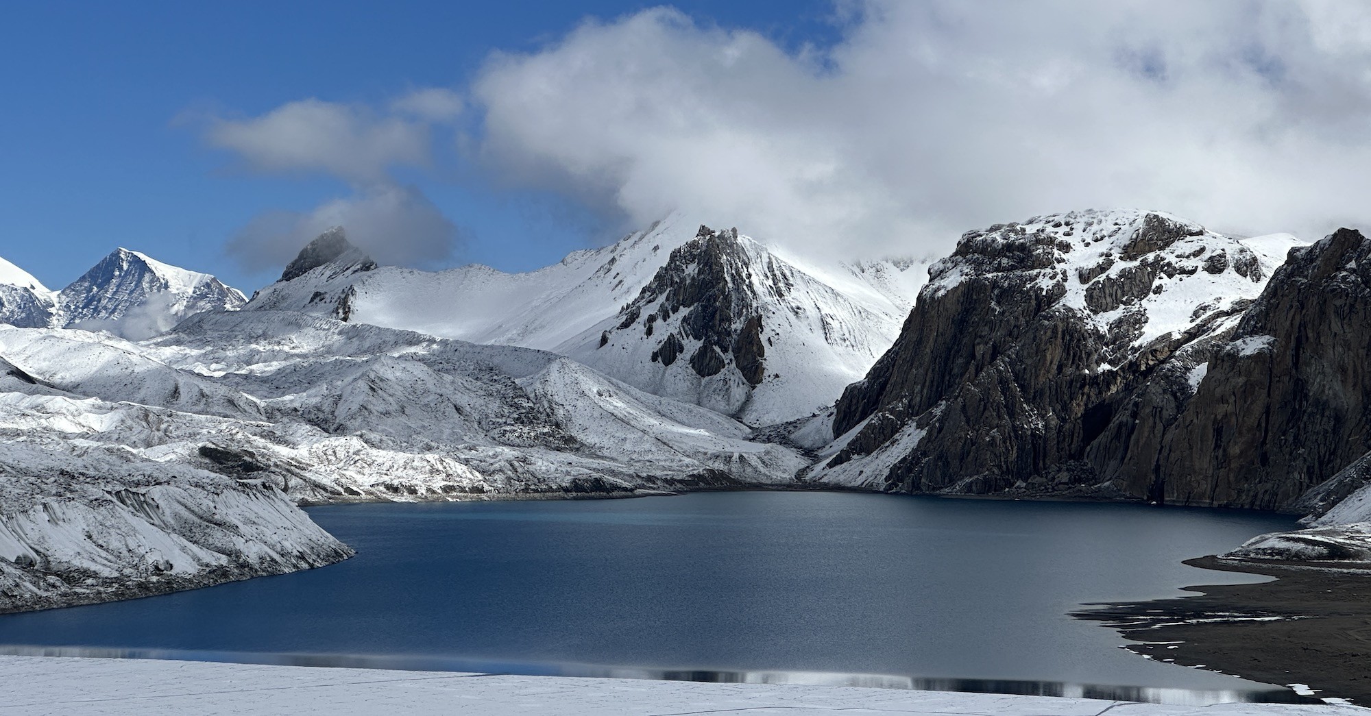
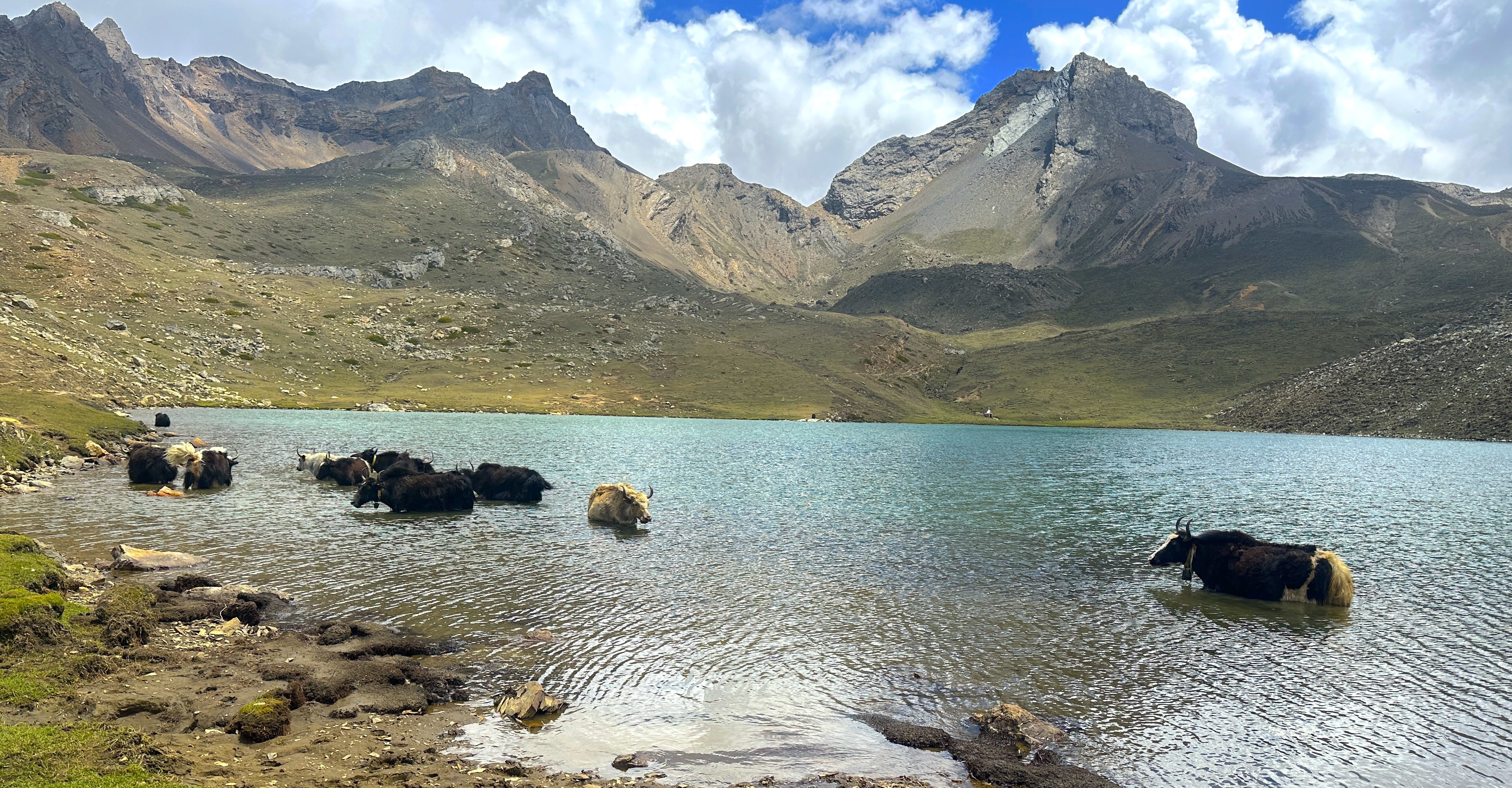
Tranquil Himalayan lake surrounded by mountain beauty.
In fact, the standard Annapurna Circuit itself is incredible in its variety, and with a side trip up to Tilicho Lake (4,919m/16,138ft), this trek gains a whole new wild and acclimatized level. You walk through high passes, traditional villages, remote deep gorges and arrive at Tilicho Lake before continuing your circuit toward the famous Thorong La pass. This final loop is what we believe to be the ultimate trek that most hikers aspire to take, and do not want the difficulty of the even more arduous Three Passes Trek.
Complete Annapurna loop without having to retrace your steps
Trekkers who want an upgraded Annapurna Circuit experience
Trek Name
Distance
Time needed | Trekking level
Standard Annapurna Circuit
160-180km
14-16 days | Moderate
Annapurna Circuit with Tilicho Lake
190-210km
17-20 days | Moderate-Strenuous
Compare itineraries :
Overall the Annapurna Circuit with Tilicho Lake is a fantastic final loop. Contact Haven Holidays to tailor an Annapurna Circuit with Tilicho Lake Trek for you.
Difficulty Level and Physical Demands: Is the Tilicho Side Trip Too Tough?
If you want to trek the Annapurna Circuit with Tilicho Lake, you need to take a hard look at your own fitness levels before starting this journey. The trek is a Moderate-Strenuous level of trekking. The standard Annapurna Circuit is challenging but accessible to almost any reasonably fit person, the Tilicho trek requires a greater level of sustained cardiovascular endurance to overcome the steep landslide moraines, successive nights above 4000m/13,123ft and the longer days.
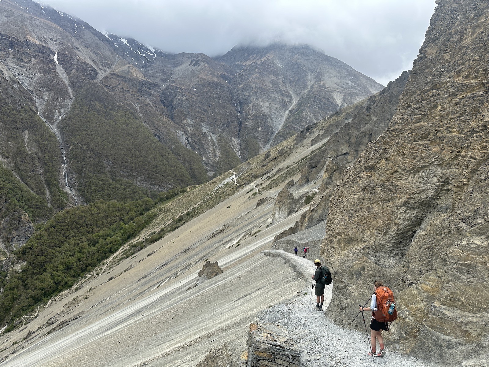
Rocky sliding trail on the way to Tilicho Base Camp – challenging Himalayan terrain.
Here, starting with the trek to Tilicho Base Camp and then up to Tilicho Lake, at a huge 4919m/16138ft, this is one of the biggest and most rewarding climbs you'll do in Nepal without ropes. It’s a demanding trek on the lungs and requires a great level of mental determination to conquer loose scree/snow and the effects of the thin air. However, by gradually walking the high parts of the circuit and including acclimatization days, this difficult trek is well within reach for most individuals who can withstand good aerobic training and have at least basic high altitude trekking experience.
Tilicho Trekking Demands:
Consistently steep climbs, steep moraine descents
Consecutive nights camping above 4000m/13,123ft
Daily treks of 6-8 hours
Strength in leg muscles for power, stability for legs on unstable ground
Mental toughness for a challenging trek in harsh conditions
Fitness Tips for the Annapurna Circuit with Tilicho Lake Trek:
Focus on cardiovascular workouts (running, cycling, stairs)
Maintain excellent core strength, hip flexors, leg muscles for stable, efficient hiking
At Haven Holidays, we assess the fitness level of each client. If the Annapurna Circuit with Tilicho Lake Trek is within your ability, your guide will keep you safe by including acclimatization days to prevent altitude sickness.
In conclusion, the Annapurna Circuit with Tilicho Lake is only moderately strenuous but is one of the most rewarding treks on the planet and highly recommended for fitness conscious trekkers. Contact Haven Holidays today for a quote on an Annapurna Circuit with Tilicho Lake Trek.
The kilometer count of the full circuit: Tracking the distances covered
Understanding the distances you’ll cover on the Annapurna Circuit with Tilicho Lake will help you prepare physically and mentally for the grand trekking experience you’re about to have. The complete circuit covers an area that can range between 180-185 kilometers of active walking and road transfers (if you opt for jeep sections occasionally). It is also worth noting that these distance figures can vary according to where your trek terminates, with option for longer treks, to further shorten with use of jeep travel.
Tracking the Annapurna circuit – every kilometer tells the story of a Himalayan journey.
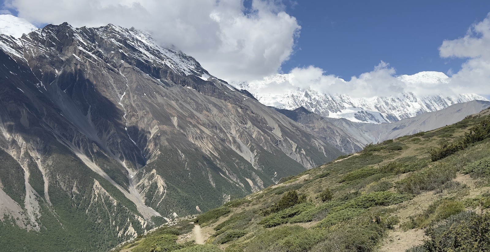
Actually, the combined trail of Annapurna Circuit and Tilicho Lake provides one of the most all-inclusive and well-rounded trekking experiences one can find in the region. You’ll traverse a huge range of terrains – the subtropical valleys and forests of rhododendrons in lower altitudes gradually changing to high alpine moraines and dramatic terrains of Tilicho area, eventually taking you across the famous Thorong La Pass.
Annapurna Circuit with Tilicho Lake Distance highlights :
Total distance of trekking trail: 180-185 kilometers (111-115 miles)
Daily distance range of trekking: 10-14 kilometers per day
Additional kilometers due to detour for Tilicho Lake
Combination of the Classic circuit plus an extensive journey at high alpine altitudes
Final exit from the trail may end in Jomsom, Tatopani or even Nayapul
Phase of the trek
Distance
Key features | Duration (trekking days)
Lower Circuit (Besisahar)
35-40 km
Marsyangdi valley and associated terrain | 3-4 days
Tilicho Lake extension
35-40 km
Trail connecting Manang to Tilicho Lake & returning to Manang | 4-5 days.
Upper Circuit and Thorong La pass
45-50 km
Manang to Muktinath via the Thorang La pass | 4-5 days
Descent from the circuit to Jomsom / Tatopani
50-60 km
The dry and sandy rain-shadow terrain | 5-6 days
Grand Total
180-185 km
Full circuit with Tilicho extension | 17-20 days
Breakdown of distances of the full circuit :
Here, Haven Holidays takes into consideration every meter of the trail while planning a trekking itinerary and ensures that the trekking distance is well balanced with rest periods so that you enjoy your journey.
Therefore, to sum up, the Annapurna Circuit with Tilicho Lake presents a substantial 180-185 kilometers trek providing variety at its best, which is an ideal choice for trekkers looking for an authentic Himalayan experience. Contact Haven Holidays today to craft an itinerary best suited for you with all the professional guidance and support required.
Altitude Profile of the full circuit: From lowest valleys to the highest peaks
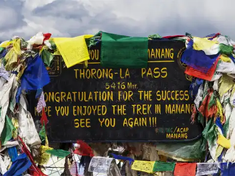
One of the most stunning attributes of the Annapurna Circuit with Tilicho Lake trail lies in its dramatic altitude range. The trekking journey starts at about 900m to 1,300m (2,953ft to 4,265ft) in the lower subtropical valleys and eventually culminates at 5,416m (17,769ft) at Thorong La Pass, the highest point in the entire trekking region. It is important to note that Tilicho Lake sits as the second highest lake in Nepal at an altitude of 4,919m (16,138ft).
Likewise, this sheer vertical range brings about varied ecology in the region and thus, the trek from lush green rice terraces and bamboo forests to the pines and rhododendron groves in higher altitude, and finally to the desolate, arid alpine landscapes below and above the tree line creates a unique and diverse environment for the trekker. While the Tilicho Lake's altitude presents itself as quite a challenge at 4,919 meters, a systematic and gradually rising profile to this lake facilitates efficient acclimatization at these altitudes.
Altitude Profile of Annapurna Circuit with Tilicho Lake :
Lowest point of the trek: around 900-1,300 meters in Marsyangdi valley
Tilicho Lake altitude: 4,919 meters (16,138 feet)
Highest point of the trek: Thorong La Pass at 5,416 meters (17,769 feet)
Many nights spent at altitudes above 4,000 meters to gain acclimatization
Contrasting environment from humid to dry arid to arctic like climates.
Stage of the trek
Altitude range
Key challenge to overcome | Acclimatization benefits
Lower valleys
900-2,500 meters
Hot and humid forest sections and river crossings | Easy warm up
Tilicho Lake and its surrounding region
3,500-4,919 meters
Extremely steep terrains and moraines surrounding the lake | Promotes the principle of hiking high, sleeping low.
Thorong La Pass
4,000-5,416 meters
Dealing with extreme cold and thin air at the highest point | Peak altitude achievement
Descent from the circuit
from 5,416 meters all the way down to 1,000 meters.
Sustained long descents can tire out legs | Rapid regaining of breath as oxygen level increase.
Vertical profile of the full circuit :
Actually, the gradient throughout the trek has been engineered to be favorable to the trekking experience. The gradual rise in altitudes as and when necessary makes the altitude sickness less prominent and more manageable on this trail. Haven Holidays takes special measures to include dedicated acclimatization days in every trekking itinerary for you.
To conclude, the Annapurna Circuit with Tilicho Lake trail offers an inimitable trekking experience with a dramatic altitude range to be experienced in Nepal, which showcases the best of natural variety. Come experience a Himalayan Odyssey with us, contacting Haven Holidays today for best support and professional service.
Best Weather Windows: Timing Your Trek for Crystal Clear Skies
Here, selecting the right dates is crucial to your safety and overall experience of the Annapurna Circuit with Tilicho Lake. The best times to trek Annapurna are generally the Spring (March-May) and Autumn (September-November) months. The weather in both seasons is generally stable, the skies are clear and visibility of the high mountains is at its best.
Best weather windows for Annapurna Circuit – the clearest skies and safest trekking conditions
Actually, Spring is famous for its spectacular Rhododendron blossoms that can light up the lower trekking routes in dazzling reds and pinks. Autumn is known for crisp, clear air and sharp, clean mountain vistas with few clouds. Both seasons offer pleasant daytime temperatures and low chances of snow on Thorong La or Tilicho Lake. In contrast, the monsoon months (June-August) are completely un-trekkable due to rain which can cause both low route landslides as well as a completely unsafe and highly dangerous Tilicho section.
Recommended Trekking seasons :
Spring (March-May): Rhododendron bloom, pleasant temperatures
Autumn (September-November): crystal-clear visibility and very stable conditions
Avoid: Monsoon (June-August) as a result of landslides and extreme lack of visibility
Season
Visibility | Trail Conditions
Rhododendron Bloom | Risk Level
Spring
Excellent | Dry & blooming
Peak | Low
Autumn
Outstanding | Crisp & stable
None | Lowest
Monsoon
Poor | Crisp & stable
None | High
Season Comparison :
Importantly, the advice at Haven Holidays is to book either a Spring or Autumn trek if you want a secure and more rewarding experience trekking to Tilicho Lake on your Annapurna Circuit trek.
To conclude, choosing to trek Annapurna with Tilicho Lake when the skies are clear makes both a safer and a far more pleasant experience. The monsoon months should be avoided due to obvious risk from landslides on Tilicho side trail. Haven Holidays is readily available and excited to help you book your fully equipped Annapurna Circuit with Tilicho Lake trek to ensure excellent timing for the best weather.
Nar Phu Valley Trek with Annapurna Circuit | 16 days days
Budget Blueprint: Deconstructing the Cost of the Tilicho Lake Package
When planning your Annapurna Circuit with Tilicho Lake Trek, understanding the cost implications can significantly help your budgeting process. If you choose an independent budget, expect roughly $900-$1500 per person for basic teahouses, food, permits, and transportation, but this demands self-sufficiency and previous experience on similar treks.
Conversely, opting for a full inclusive agency package with Haven Holidays, the estimated cost will fall between $1,100 and $2,200 per person (depending on group size, teahouse type and what's included), offering guides, logistics support and emergency evacuation in one clear cost. The Tilicho section is particularly treacherous so professional support is highly recommended for anyone tackling it.
Expense Category
Independent Budget
All-inclusive Package
Permits & TIMS/ACAP
$50-80
Included
Teahouses & Meals
$400-700
Included
Guide & Porter (recommended)
$300-500
Included
Transportation & Flights
$150-250
Included
Total Estimated Cost
$900-1,500
$1,100-2,200
Cost breakdown comparison :
As illustrated in the table above, most trekkers will benefit from an all-inclusive package as it removes the stress of logistically managing their trek, particularly with the complexities surrounding the high Tilicho route. Haven Holidays assures their quotes have absolutely no hidden extras and the price will vary slightly depending on your specific group needs.
Key price affecting factors :
Group size (smaller group=higher individual price)
Teahouse accommodation type
Tilicho side-trip inclusions
Guide/porter to client ratio & relevant emergency equipment available
In conclusion, the Annapurna Circuit with Tilicho Lake trekking package will represent excellent value whether you decide on an individual budget or a fully inclusive approach. Contact Haven Holidays today for a precise quote for your trekking party.
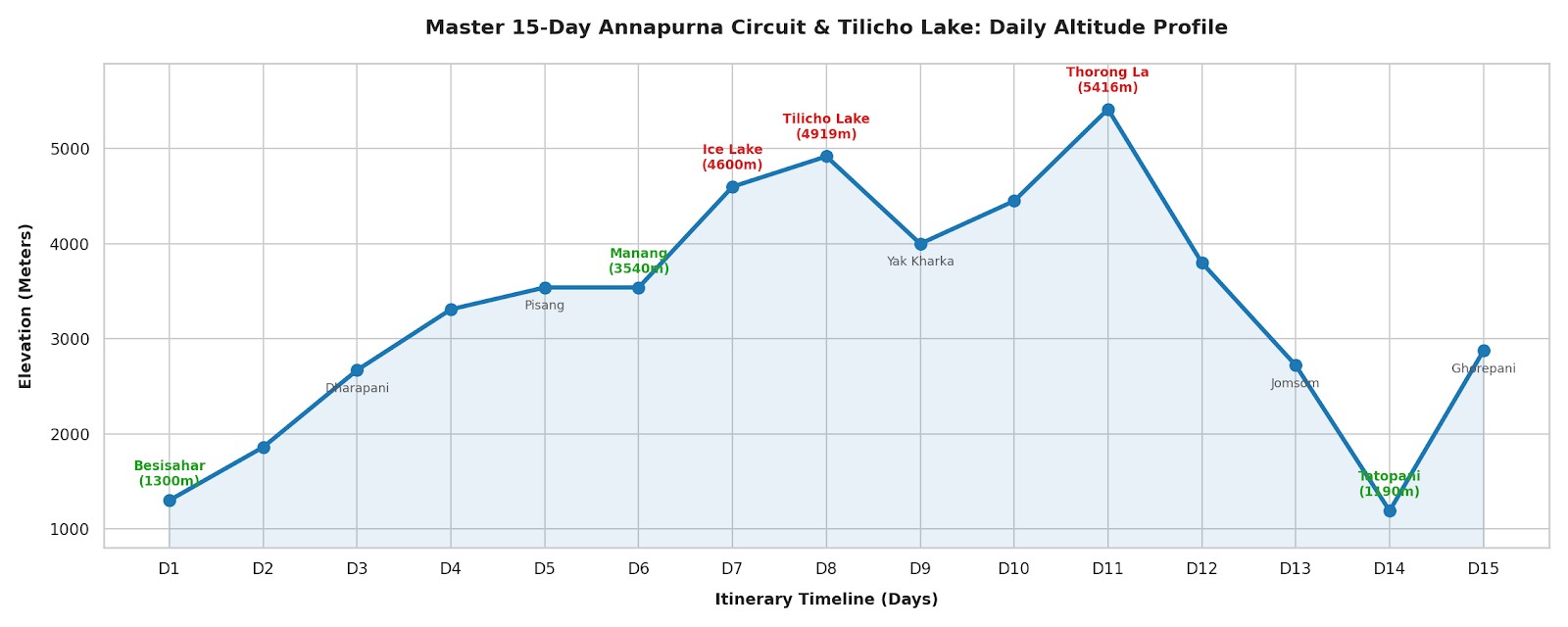
The Master 15-Day Daily Itinerary: A Step-by-Step Trail Blueprint
Meanwhile, a well planned schedule is key for success on the Annapurna Circuit with Tilicho Lake. The suggested 15-day itinerary (which is adjustable between 14 and 16 days) combines the classic circuit and the Tilicho extension logically with the necessary safety precautions built-in. The 14 to 16 day window is a required duration in order to complete the Tilicho Lake section and Thorong La Pass without compromising on acclimatization.
Day | Route Segment
Distance | Walking Hours
Elevation (m) | Highlights
1 | Besisahar to Ngadi / Jagat
12-15 km | 5-6 hrs
1,000 - 1,300 | River valley warm-up
2 | Jagat to Dharapani
14-16 km | 6 hrs
To 1,860 | Marshyangdi Gorge
3 | Dharapani to Chame
15-16 km | 5-6 hrs
To 2,670 | Pine forests & first peaks
4 | Chame to Pisang
16-18 km | 6-7 hrs
To 3,310 | High route via Ghyaru/Ngawal
5 | Pisang to Manang
12 km | 5 hrs
To 3,540 | Acclimatization arrival
6 | Manang Rest + Ice Lake
8-10 km | 5-6 hrs
To 4,600 | Active acclimatization
7-8 | Manang to Tilicho Base Camp & Lake
18-22 km | 6-8 hrs
To 4,919 | Tilicho Lake highlight
9 | Tilicho Base Camp to Yak Kharka
12 km | 5-6 hrs
Descent | Return to main circuit
10 | Yak Kharka to Thorong Phedi
10 km | 5 hrs
To 4,450 | Pre-pass staging
11 | Thorong La Pass to Muktinath
16-18 km | 8-10 hrs
5,416 m Pass | High pass crossing
12 | Muktinath to Jomsom / Kagbeni
15-18 km | 5-6 hrs
Rain shadow | Temple & apple orchards
13 | Jomsom to Tatopani
20-25 km | 6-7 hrs
Descent | Hot springs recovery
14 | Tatopani to Ghorepani
15-17 km | 7-8 hrs
Steep ascent | Rhododendron forests
15 | Ghorepani - Poon Hill - Nayapul
16-20 km | 6-7 hrs
Final descent | Sunrise & circuit completion
This is a proven high-success blueprint: 15-Day Annapurna Circuit with Tilicho Lake Itinerary
The Master 15-Day Annapurna Circuit itinerary – a step-by-step trail blueprint from start to finish in the Himalayas.
In fact, this master 15-day itinerary balance the Tilicho detour with ample rest and acclimatization days for a high chance of success.
In conclusion, this step-by-step trail blueprint assures a safe trek through both the classic circuit and the stunning Tilicho Lake. Contact Haven Holidays today to customize this 15-day Annapurna Circuit with Tilicho Lake itinerary to your own pace and preferences.
The Gateway Approach: Driving from Kathmandu to the Besisahar Trailhead
Here, your Annapurna Circuit with Tilicho Lake adventure begins with the gateway approach – the rugged road transfer from Kathmandu to the Besisahar trailhead. This land journey spans approximately 180 kilometers and will take you 8-9 hours via private jeep on local tracks, passing through scenic rural valleys.
Kathmandu to Besisahar tourist bus – the scenic gateway journey to the Annapurna Circuit.
In fact, you’ll drive past terraced hillsides, local villages, and the mighty Marsyangdi River before reaching Besisahar, and then continuing on to Jagat or Ngadi where the bulk of your trekking journey will begin. This drive provides the perfect introduction to the Himalayas and the rural environment you are about to explore, as well as offering the opportunity for a final briefing with your guide.
Kathmandu to Besisahar Road Transfer Highlights :
Distance: 180 km
Duration: 8-9 hours by comfortable jeep
Scenic rural trail access through countryside
Opportunity to bond with your trekking team
Efficient start at the Marsyangdi Valley trailhead
Stage
Distance | Duration
Experience
Kathmandu to Besisahar
170 km | 6-7 hours
Highway with river views.
Besisahar to Jagat/Ngadi
10-15 km | 1-2 hours
Rugged mountain road.
Total
180 km | 8-9 hours
Gateway to the Annapurna Circuit.
Transfer Overview :
Importantly, Haven Holidays arranges for safe and comfortable private jeeps with expert drivers and all required permits, so you will be all set to reach the trailhead in an organized and safe manner.
In conclusion, the gateway approach from Kathmandu to Besisahar is a solid and organized first step for your Annapurna Circuit with Tilicho Lake Trek. Contact Haven Holidays today to schedule your seamless transfer and entire guided tour from day one.
Here are the rewritten sections:
Non-negotiable acclimatization rules: Your rest day in Manang is crucial
Meanwhile, your rest day in Manang should not be underestimated. At an elevation of 3,540m (11,614ft), it's the medical heart of the whole Annapurna Circuit with Tilicho Lake Trek. Failing to acclimatize properly here is one of the leading causes of AMS further along the route.
Manang rest day acclimatization – exploring the Ice Lake for safe altitude adjustment.
In fact, this should not be an 'active' rest. Instead of a full rest day, engage in 'hiking high, sleeping low'. Hike to local viewpoints, ancient monasteries, or the beautiful Gangapurna glacier to acclimatize actively in Manang. These short but rewarding hikes prepare your body to produce more red blood cells to survive the 4,000m+ regions ahead, particularly for the Tilicho Lake and the Thorong La Pass.
Key Manang acclimatization day rules :
Mandatory 1-2 full days acclimatizing at 3,540m (11,614ft)
Active hike to build tolerance
Well-equipped teahouses and bakeries for recovery
Plenty of time to experience traditional Manang culture
A critical precursor to the Tilicho detour
Destination
Round trip distance
Maximum elevation | Purpose
Gangapurna Glacier viewpoint
3-5km
3,700m | An easy scenic hike
Ice Lake
10km
4,600m | Proper altitude training
Ancient monasteries
4-6km
3,800m | Culture and light acclimatization
Acclimatization hikes suggested from Manang :
Importantly, the team at Haven Holidays incorporates ample acclimatization time in the itinerary and conducts regular health check-ups to ensure your safety.
Overall, a rest day in Manang is indispensable for avoiding acute mountain sickness and ensuring the rest of the trek is enjoyable and successful. Contact Haven Holidays today to book your Annapurna Circuit with Tilicho Lake Trek with properly paced, safe arrangements.
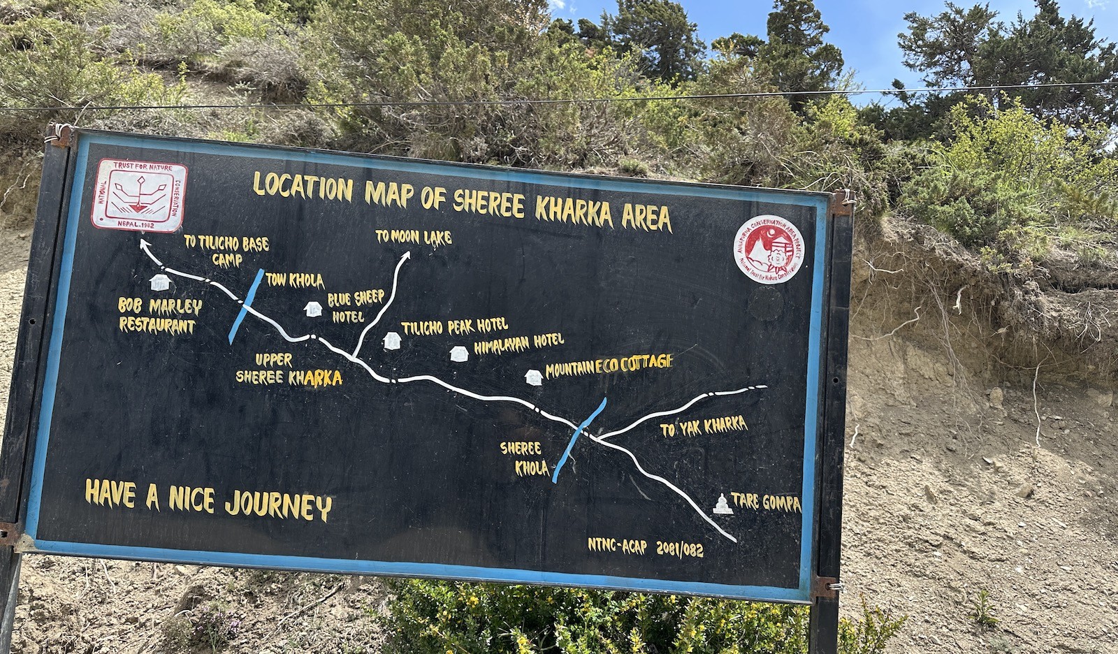
Splitting the path: Manang's descent into Siri Kharka's scree zones
Here, you reach a major trail junction just before Manang where the trail diverges from the main Annapurna Circuit and heads towards the direction of Tilicho Lake. You then turn west and enter a wilder, less developed part of the Annapurna range. The walk towards Siri Kharka at 4,060m (13,320ft) goes through narrow, rocky, and loose scree channels as well as through wind-exposed, unstable landslide slopes.
Manang to Siri Kharka route split – navigating scree terrain in the Annapurna region.
In fact, this section of the trek requires your full concentration as the trail gets narrow and loose scree stones are likely to slide and roll down. Hikers should always move quickly through landslide areas without stopping to take photos and thus minimizing the risk of being hit by falling stones. The trail takes a sharp turn towards the northern face of the Annapurna range; the surrounding mountainous terrain is stunning in its raw beauty.
Key Manang to Siri Kharka trek features :
Junction where you break from the main AC trail.
Narrow scree sections and landslide zones.
Breath-taking views of the Annapurna range.
A remote, serene high valley environment.
A crucial resting point prior to reaching Tilicho Base Camp.
Important safety tips for the Tilicho route :
Maintain a steady, constant pace on the unstable trails.
Use trekking poles for support on loose scree.
Always listen to and obey your guide.
Stay alert for falling rock alerts.
Ensure you have ample water and protection against the sun.
Most importantly, the guides at Haven Holidays are seasoned on the Annapurna range and place paramount importance on the safety of trekkers while ensuring that they have an enjoyable experience traversing this unique wilderness.
Ultimately, splitting the path from Manang to enter the Siri Kharka scree zone signals your ascent into the wild Tilicho range. This portion of the trek, taken with measured steps and a respect for the environment, is among the most rewarding experiences. Contact Haven Holidays to embark on this extraordinary route with expert guides and comprehensive safety measures.
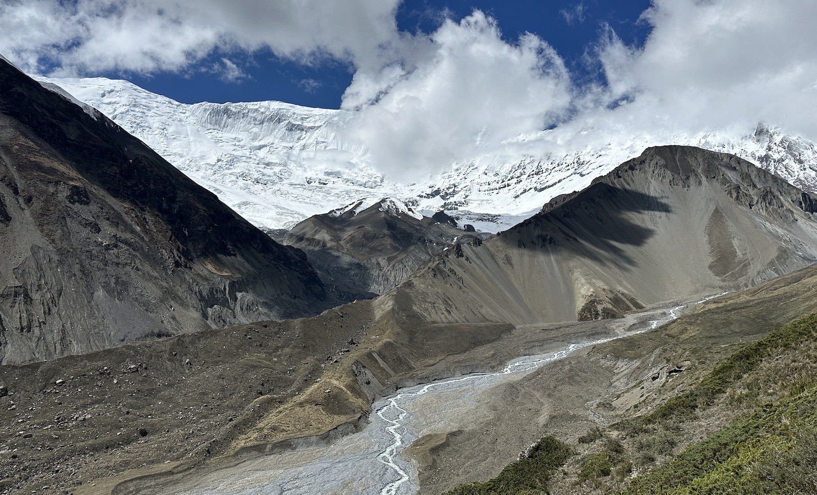
Tackling the Lake: The Pre-Dawn push from Base Camp to Tilicho Lake
Actually, this adventure trekking to one of the world's highest alpine lakes is an obvious visual highlight of your trip, but also an immense physical feat. For this side trip, you'll have to scale a sustained, steep moraine wall that bounds the northern edge of the valley. Since you are traversing high up in the alpine zone, managing your temperature and breathing is the key to reaching the lake waters safely.
[Tilicho Lake Rim Base: 4,919m] High Icy Destination- (Steep Switchbacks) (+769m Vertical Elevation Climb)-
[Tilicho Base Camp Hub: 4,150m] One-Way Horizontal Distance: 5.0 km / 3.1 miles
Tilicho Lake – a challenging high-altitude Himalayan trail.
To make this journey a manageable endeavor, you need to ensure you begin this trip well before dawn; ideally, leaving the Tilicho base camp elevation 4,150m no later than 5:30 AM to arrive at the pass before the freezing afternoon ridge winds really set in. Pacing yourself properly up the arduous, sheer 769m vertical climb will allow you to reach the famous shores of this lake, renowned as the highest alpine lake on Earth.
Survival Strategies for the Lake Ascent :
Counter the Valley Winds: Severe, freezing winds descend from the high plateau, starting around 11 AM, and blow across the pass at high speed.
The Glacial Switchbacks: the trail ascends through an unbroken series of extremely steep, brick-red scree switchbacks where every few feet loose gravel or morning frost require you to step cautiously and maintain your balance.
Stay Hydrated: In the extremely cold, dry air at over 4,500m, your body quickly dehydrates through respiration and this significantly contributes to altitude sickness and headaches; carry an insulated water flask.
The Lake Plateau: At the crest of the steep climb, the moraine is replaced by a vast snowy plain stretching right to the edge of Tilicho lake, with deep blue water, surrounded by the massive ice walls of Tilicho peak (7,134m).
Ascent Trail Segment Node
Elevation Metric | Oxygen Availability
Avg. Walking Time | Trail Quality & Footing
Tilicho Base Camp
4,150m / 13,615ft | 60% of sea level
Departure | Hard-packed dirt paths on the valley floor.
The Great Slope Crest
4,680m / 15,354ft | 56% of sea level
2.0 - 2.5 Hours | Loose gravel and steep shale and scree switchbacks.
Tilicho Lake Rim
4,919m / 16,138ft | 54% of sea level
1.5 - 2.0 Hours | Open snowy plains and some icy rock patches.
Technical Profile: Base Camp to Tilicho Rim Ascent :
Back on the Ring: Trekking from Siri Kharka to Yak Kharka
Following your return from Tilicho Lake to Base Camp, you now rejoin the main Annapurna Circuit trail, rather than trekking back all the way down to the Manang valley floor and walking back uphill for kilometers with unnecessary repetitive scenery. The route you take crosses the valley over the higher ridge directly into the Jarsang Khola valley.
Trekking from Siri Kharka to Yak Kharka – crossing open alpine landscapes in the Annapurna Circuit.
Actually, this leg serves as an important link in your high-alpine route and you will follow the Siri Kharka to Yak Kharka bypass via the old, almost abandoned village of Old Khangsar, to seamlessly rejoin the circuit loop in the Jarsang Khola valley just below Yak Kharka or Ledar, and continue your high-altitude progress toward Thorong La Pass.
High-Altitude Connection Practices :
The Old Khangsar Trail: From Siri Kharka you drop down to the valley floor before climbing steeply up to the ancient village of Old Khangsar, where you will see Gungang Himal.
The High Ridge Traverse: Once through the crumbling, ancient stone dwellings, the bypass leads you along a mountain path across the sides of the valley, high above the lake basin at a consistent altitude of around 4,000 meters.
Altitude Safety: Since you'll still be high up on the mountain slopes, remember to maintain strict high altitude mountain safety and follow the usual altitude protocols of drinking vast quantities of water.
The Thorong Lane Junction: At the end of the bypass, you'll drop down slightly to meet the main Annapurna Circuit trail just before the lodges in Yak Kharka, ready to head toward Thorong Phedi.
Connector Trail Checkpoint
Target Elevation | Inter-Station Distance
Est. Walking Duration | Landscape & Exposure Level
Siri Kharka Outpost
4,060m / 13,320ft | 0.0km / 0.0 miles
Departure | Soft dirt tracks through open scrub hills.
Old Khangsar Ruins
4,110m / 13,484ft | 4.5km / 2.8 miles
2.0 - 2.5 Hours | Abandoned dry-stone buildings and stone wall fragments.
Thorong River Bridge
3,960m / 12,992ft | 7.5km / 4.7 miles
1.5 - 2.0 Hours | A narrow suspension bridge over a narrow river gorge.
Village Yak Kharka
4,050m / 13,287ft | 10.2km / 6.3 miles
1.0 - 1.5 Hours | The wide and popular Annapurna Circuit path.
Route Logistics: Siri Kharka to Yak Kharka Connector
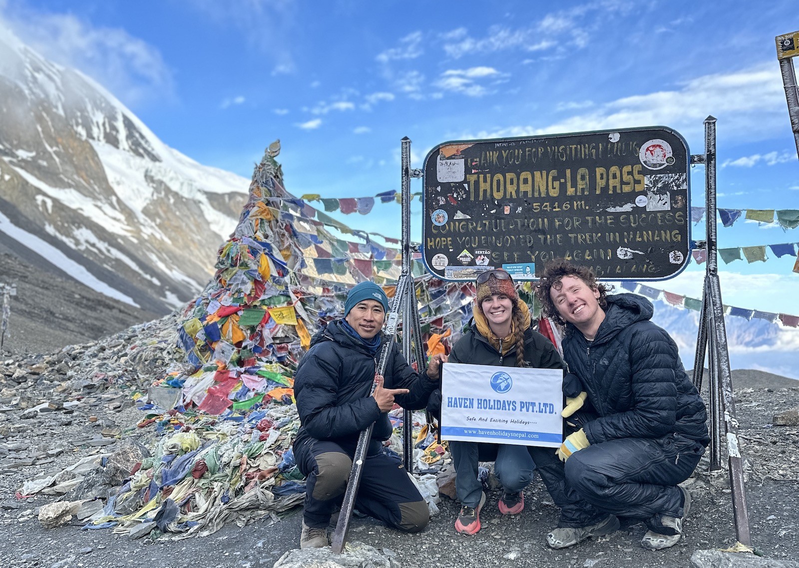
Summiting the Absolute: Successfully Conquering the Thorong La High Pass
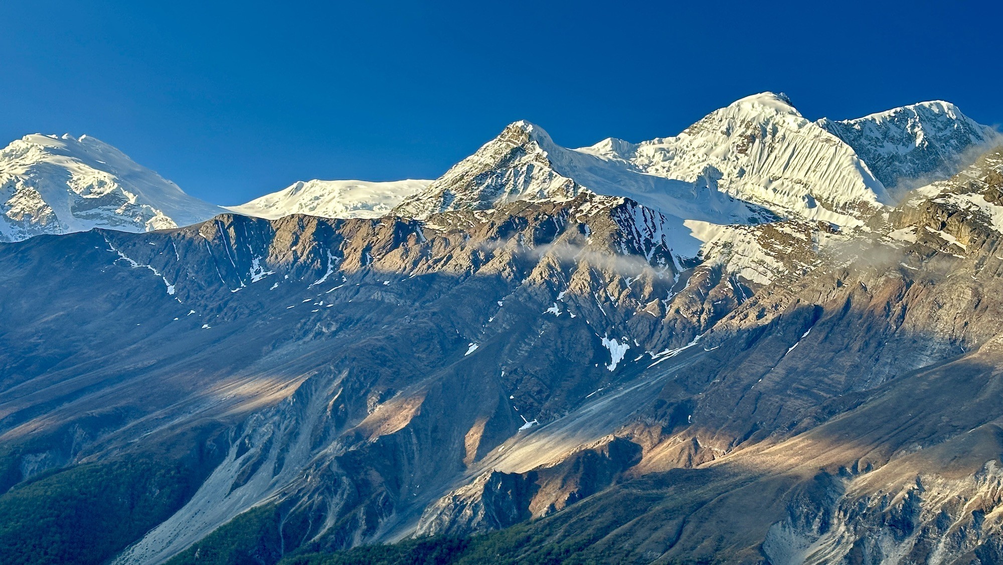
Actually, this is THE ultimate challenge of the entire Annapurna Circuit – a cold, high altitude mountain pass that tests your physical endurance, mental fortitude and degree of acclimatization. You will depart in the depths of the pre-dawn morning from the frost-chilled lodges in the upper valley and venture into a harsh, alpine wonderland to scale the enormous col which separates the Khatung Kang and Yakawa Kang peaks.
Thorong La Pass – the highest and most challenging point of the Annapurna Circuit.
[Thorong La Pass Summit: 5,416 m]- (1,650m unforgiving descent to the knees)- (Steep 3 hour switchbacks down)
Here, you begin this demanding trek from the wind-battered shacks of Thorong Phedi High Camp long before sunrise. At an elevation of 4,850 meters (16,000ft) you are already on the fringes of true alpine, where simple movements require concerted effort. Venturing through frozen terrain you push over the lip to the official crossing Thorong La pass height of 5,416 meters (17,769ft), a sheer mountainous col that requires strict adherence to extreme high altitude adaptation techniques and slow progress.
Facts of the summit climb :
The icy ascent path: Your path out of High Camp ascends sharply via a string of black scree switchbacks; frigid, icy slopes at sub-zero temperatures that render your pace to a glacial creep.
Managing the cold: At such extreme altitude, biting wind during the early morning can lower the apparent temperature significantly below zero, so ensure that you get your clothing layers on promptly and don't linger over slow moving.
The thin air zone: By the time you reach the top, the air is significantly less dense, and there is barely half the oxygen of at sea level, so it is crucial to adopt a calm and slow, consistent breathing pattern.
The harsh descent to the south: Having admired the cairns and prayer flags that mark the pass, you still have a lung burning, knee-straining 1,650-vertical-meter descent down steep, barren scree slopes toward the tranquil valley of Muktinath.
Pass Crossing Phase Node
Target Elevation | Oxygen Level Metric
Cumulative Distance | Primary Physical Strain Type
Thorong High Camp
4,850 m / 15,912 ft | ~55% of sea level
0.0 km / 0.0 mi | Strenuous cardiac exertion straight after rising.
Thorong La Pass Summit
5,416 m / 17,769 ft | ~51% of sea level
5.0 km / 3.1 mi | Intense endurance effort across snowy, open terrain.
Chabarbu Resting Point
4,190 m / 13,746 ft | ~59% of sea level
11.5 km / 7.1 mi | Excessive joint stress on scree and slate trails.
Muktinath Shrines
3,760 m / 12,335 ft | ~64% of sea level
15.0 km / 9.3 mi | Muscular fatigue at the end of the walk toward the valley floor.
Packing Necessities: Layers to fend off sub-zero conditions on the ridge-tops
Meanwhile, high passes in the mountains, like Thorong La, are cold at any time of year and require appropriate cold-weather gear and clothing that responds readily to extreme variations in the weather. As soon as you get above the tree-line your everyday hiking gear won't be enough to keep you warm and toasty. The main focus of your Annapurna Circuit packing list will be creating a series of layers to trap your body's heat, yet still effectively shed the perspiration generated by trekking through steep and rugged terrain.
[ Layer 3: Waterproof & Windproof Outershell]
[ Layer 2: Heavy Fleece & Down Layer]
[ Layer 1: Breathable Merino Base-Layers (Top and Bottom)]
In fact, being adequately prepared for the high pass will be a priority and will need careful thought ahead of time. To beat the freezing temperatures of the morning you will need to pack high quality merino wool base layers, warm insulating jackets, trekking poles to aid stability on steep slopes, and most importantly an unheated lodge room at Thorong High Camp makes an extremely high quality sleeping bag for sub-zero temperatures essential. A minus ten degrees Celsius rating is the minimum to guarantee a decent night's sleep the night before you summit.
Essential high altitude inventory :
The warm under-layer: Pack at least two sets of middle-heavyweight, 100% merino wool underwear, that wicks away moisture quickly and retains body heat even if damp from exertion.
The puffy insulating jacket: Pack a quality down jacket with a minimum fill power of 700 and a well designed hood; this is your life saver at rest stops and on frosty morning approaches.
The eyesore reducer: High altitude sunshine reflects extremely intensely from snow, meaning that protection against sun-blindness is mandatory so ensure you pack high-quality Category 3 or Category 4 UV protection sunglasses.
Your balance-aiding poles: These save your legs, especially the joints of your knees; and are of particular help as you ascend towards and begin to traverse the snowfields at the top.
Equipment Category
Minimum required specification
Best choice of material | Primary safety benefit
Sleeping Bag
minus ten to minus fifteen degree centigrade comfort
700+ fill power of Goose Down or good quality Synthetic fill | This will prevent your body from succumbing to hypothermia within your cold bedroom
Insulating Jacket
A warm Down jacket with a minimum fill power of 700 and a Hood
Box Baffled Down | this jacket should ensure your core is well warmed during the cold early morning walk.
Trekking Poles
Aluminium construction with durable lever locking
Lightweight but robust aluminium or high strength carbon fibre | they add an extra dimension of stability to your walking, preventing trips on snow and ice.
Sunglasses
Category 3 or 4 UV Rated with scratch and anti-fog resistance
high impact, anti-scratch polycarbonate lenses | Your eyes are extremely vulnerable at high altitude to both the reflection of sun-light from snow, and the intensity of the sun’s rays at high altitude.
Spikes for your Boots
Flexible rubber based microspikes
stainless steel to give extra durability to the spiked sections | to prevent yourself from slipping and injuring yourself on steep snow and icy trails.
Gear Specification for the High Pass :
Conclusion: The Final Word on Choosing a Tilicho Circuit Package
Doing the Annapurna Circuit, with the extra adventure to Tilicho Lake, presents one of the greatest, most rewarding wilderness trekking experiences in the Himalayas. From the lush, sub-tropical river valleys to the windswept, glacier-fed lake at high altitude, this trek delivers an incredible variety of terrain and scenery, pushing your physical and mental capabilities all while granting you vistas of the planet's tallest mountains.
[Manang Valley Hub] [Tilicho Glacial Lake: 4,919m] [Thorong La Pass: 5,416m]
For your safe and seamless trekking experience in this stunning high-altitude environment, two elements are of the utmost importance. First, ensure you obtain your mandatory permit requirements ACAP TIMS (Annapurna Conservation Area Project and Trekkers' Information Management Systems) in Kathmandu or Pokhara before heading off on your trek. Secondly, in this region with volatile weather conditions and unstable ground underfoot in high scree fields, it is highly advised to book with licensed guides. They offer not just vital local knowledge but also provide a support system that is indispensable for a challenging journey such as this.
Key to Safe Mountain Travel :
The Advantage of a Guide: A professional, certified guide is invaluable for checking the conditions of trails through landslide-prone areas and closely monitoring your daily acclimatization rate.
Mindful Altitude Gains: Trekking at high altitude requires patience. Allocate extra rest days to aid in altitude acclimation. The village of Manang and Siri Kharka are the most popular spots for extended stays.
Respect the Weather: High mountain passes must be crossed early in the morning. If the weather takes a turn or a snowstorm begins, it's always safest to descend to the nearest teahouse and wait for conditions to improve.
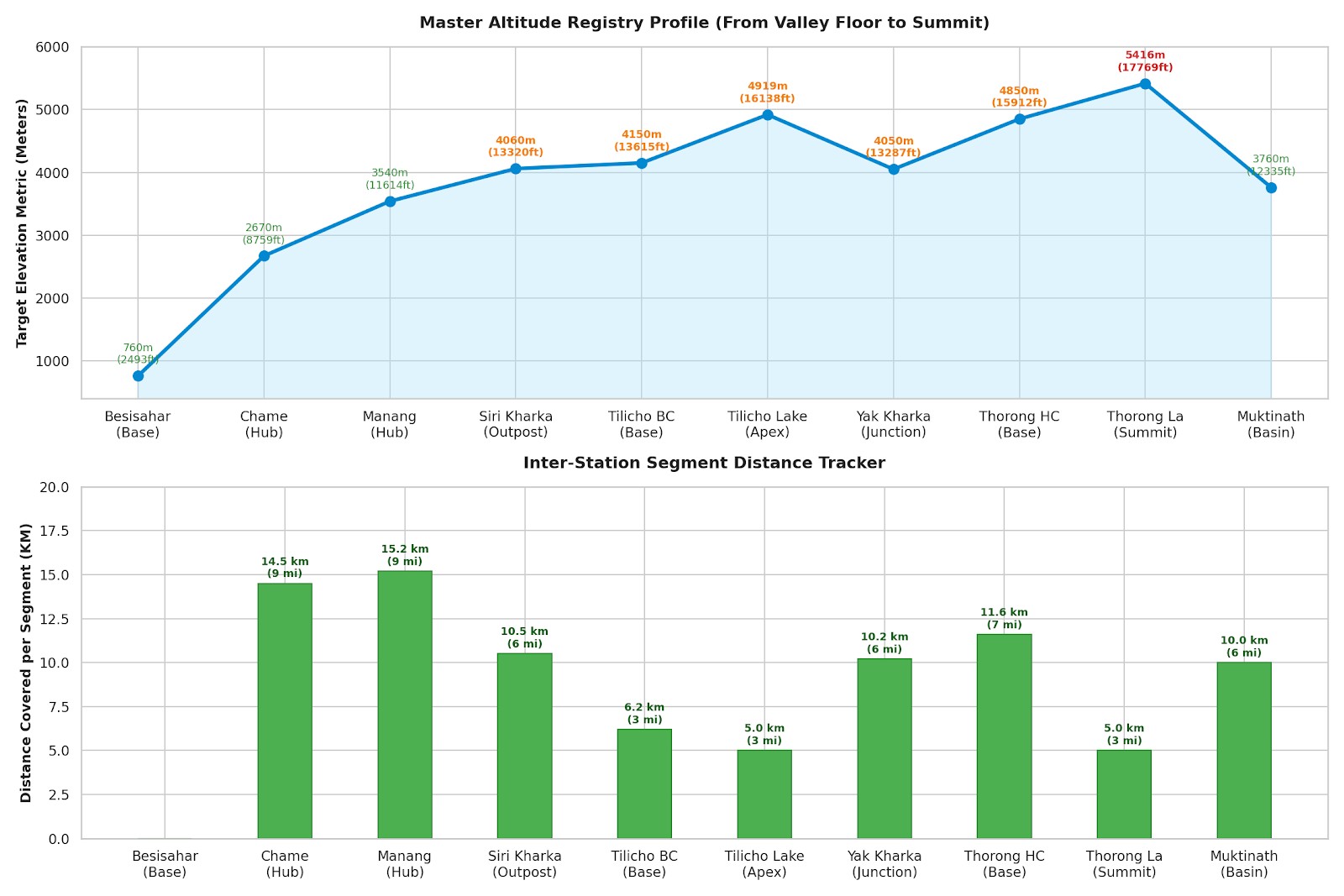
Master Distance and Altitude Milestone Registry
Core Route Milestone Station
Target Elevation Metric | Inter-Station Distance
Average Hiking Duration | Terrain & Safety Environment
Besisahar Trailhead Base
760m / 2,493ft | 0.0km / 0.0mi
Drive Day | Starting point and a check point, situated in the sub-tropical valley floor.
Chame District Hub
2,670m / 8,759ft | 14.5km / 9.0mi
5-6 Hours | Hiking through pine forests alongside the rocky Marsyangdi River.
Manang Acclimatization Hub
3,540m / 11,614ft | 15.2km / 9.4mi
5-6 Hours | A high alpine valley offering an ideal place to rest and adjust to the altitude.
Siri Kharka Outpost
4,060m / 13,320ft | 10.5km / 6.5mi
4-5 Hours | Upper valley singletrack winding its way to the Tilicho lake trail.
Tilicho Base Camp
4,150m / 13,615ft | 6.2km / 3.8mi
3-4 Hours | Low altitude valley located below a section of active scree slopes.
Tilicho Lake Rim Apex
4,919m / 16,138ft | 5.0km / 3.1mi
3-4 Hours | A high altitude, glacial lake plateau; typically wind-swept snow paths. (Return to Siri Kharka).
Yak Kharka Bypass Junction
4,050m / 13,287ft | 10.2km / 6.3mi
4-5 Hours | High alpine trail diverting off the main path, bypassing the Manang Valley.
Thorong High Camp Base
4,850m / 15,912ft | 11.6km / 7.2mi
4-5 Hours | A very stark, barren plateau providing the final stopping point before the pass.
Thorong La Pass Summit
5,416m / 17,769ft | 5.0km / 3.1mi
3-4 Hours | High mountain pass; a challenging crossing due to extremely low oxygen levels.
Muktinath Shrine Basin
3,760m / 12,335ft | 10.0km / 6.2mi
4-5 Hours | A steep descent into the arid Mustang valley and a religious shrine.
Here is a summary table that clearly outlines the main points on the Tilicho Circuit route, the distances between each station, and average hiking durations:
Final Word on Safety: The timings and distances mentioned above are intended as guides and may vary depending on numerous environmental and personal factors. Prioritize your health and safety over reaching your daily targets, especially at such high altitudes, for a truly unforgettable Himalayan experience.
In final words, an incredible journey that combines the world's most varied long-distance mountain loop with a trek to the highest lake of its size, the Annapurna Circuit with Tilicho Lake trek demands careful planning when it comes to trail lengths, elevations, and routing options.
Annapurna Circuit with Tilicho Lake-FAQs
1. How many days does it take to do the Annapurna Circuit with Tilicho Lake trek? A typical Annapurna Circuit with Tilicho Lake trek itinerary is 15 to 18 days long. This duration accounts for the vital Tilicho Lake side trip, standard acclimatization days and the completion of Thorong La Pass in safe conditions.
2. How much will the Annapurna Circuit with Tilicho Lake trek cost? The average Annapurna Circuit with Tilicho Lake trek cost can be between $900 and $1,500 per person. The final total will depend heavily on whether you book a full inclusive agency trip, hire a personal porter, or trek self-sufficiently with personal teahouse payments.
3. What is the total length of the Annapurna Circuit with Tilicho Lake trek? Doing Annapurna Circuit with Tilicho Lake trek distance is approximately 180-220 kilometers (111-136 miles). This can vary depending on which vehicle ride you take at the trailheads and end points.
4. What is the maximum altitude on the combined Annapurna Circuit with Tilicho Lake trek? The highest point the Annapurna Circuit with Tilicho Lake trek altitude profile can reach is the Thorong La Pass, at 5,416m (17,769ft). The Tilicho Lake side trek culminates at a spectacular 4,919m.
5. Is the Annapurna Circuit with Tilicho Lake trek challenging for first-time hikers? Overall, the Annapurna Circuit with Tilicho Lake trek difficulty is strenuous. Although it is a purely walking trail, the week-long duration, high-altitude conditions and possible landslides do not make it the best trek for first-timers.
6. From which village is the side trek to Tilicho Lake normally branched off from the circuit? The common Annapurna Circuit with Tilicho Lake trek route splits from the main trail at the village of Manang (3,540m). Instead of heading towards Yak Kharka, walkers will take the western fork through Siri Kharka to reach the lodge at Tilicho Base Camp.
7. How many extra days does a detour to Tilicho Lake add to the Circuit? A side trek to Tilicho Lake trek adds approximately two to three days to a typical Annapurna Circuit itinerary. This period includes walking to Tilicho Base Camp, the early morning trip to the lake and return journey to the main route to Thorong La Pass.
8. How high is Tilicho Base Camp located? Tilicho Base Camp is situated at a high altitude of 4,150m (13,615ft). This serves as a mandatory lodging point for trekkers prior to the final ascent to the lake where accommodation facilities are basic but functional and drinking lots of water is mandatory.
9. Is there a risk of danger on the landslide on the Tilicho Lake trek? A section of the path from Siri Kharka to Tilicho Base Camp crosses a widely known landslide. This is the most significant factor contributing to the Annapurna Circuit with Tilicho Lake trek difficulty, with a thin track having to be negotiated between rolling stones and loose scree.
10. Can you do the Annapurna Circuit with Tilicho Lake trek alone without a guide? Although it is permitted to trek independently in the Annapurna region, a guide is strongly advised. The Annapurna Circuit with Tilicho Lake trek difficulty and unpredictable mountain weather conditions are not a good combination for any unaccompanied trekking experience.
11. What permits do you need for the Annapurna Circuit with Tilicho Lake trek? You are required to obtain two primary passes to access the Annapurna Circuit with Tilicho Lake trek route. These are the Annapurna Conservation Area Project (ACAP) permit and the TIMS card, both of which will be inspected at various locations along the path.
12. How is accommodation on Annapurna Circuit trek? The available accommodation is in locally owned mountain lodges called teahouses. The amenities on the main circuit are of a decent standard, with bathrooms on offer. However, the conditions at Tilicho Base Camp (4,150m) are somewhat more rudimentary. Shared facilities will have to be used by the trekkers with shared bedrooms also a feature.
13. Do food and drink costs change along the Tilicho Lake route? Prices are highest on the higher altitude sections of this trek due to the difficulty of transporting supplies up the mountains via mules and porters. A bottle of water or meal, which costs very little at the start of the trek, could cost double or even triple the amount at Tilicho Base Camp or Thorong Phedi.
14. What are the best times to go on the Annapurna Circuit with Tilicho Lake trek? Autumn (September to November) and Spring (March to May) are the ideal times to complete this Annapurna Circuit with Tilicho Lake trek itinerary. The trails are clear and dry during both periods and safe conditions for crossing Thorong La Pass are expected.
15. How much cash do you need for the Tilicho Lake trek side trip? You should carry approximately NPR4000-NPR6000 per day on this trek. Credit cards are generally not accepted along the high trail or at the remote teahouses on the Tilicho route, so you need cash to pay for hot showers and charging points etc.
16. What is the probability of crossing Thorong La Pass after Tilicho Lake? Going to Tilicho Lake will improve your chance of crossing Thorong La Pass. Staying for a number of days at high altitude (4,919m) ensures that your body gets used to the altitude and helps your respiratory system adjust.
17. Is travel insurance a requirement for the Annapurna Circuit with Tilicho Lake trek? Yes, a specialized travel insurance is mandatory for the high altitude nature of the Annapurna Circuit with Tilicho Lake trek altitude profile. It needs to cover medical treatment and rescue transport up to 6,000m.
18. How long does the hike from Tilicho Base Camp to the lake take? The trek from Tilicho Base Camp to the lake takes between 5 and 6 hours. You will experience a 800m gain in elevation from Base Camp up to the lake and a subsequent descent back down again.
19. Are helicopter rescues possible on Tilicho Lake Trek? Yes, it is possible for helicopter rescues to occur in this region if a trekkers health deteriorates to severe levels on account of AMS. Flat areas are present near Tilicho Base Camp that could act as landing sites for evacuation transport. Descent is the ultimate treatment though.
20. How do I prepare for the physical demands of the Annapurna Circuit with Tilicho Lake trek difficulty? A preparation period of 8-12 weeks is recommended to develop sufficient cardio and endurance levels. You should focus on exercises for your legs such as loaded hill climbing and long-distance runs.