[{"name":"Everest Base Camp Helicopter Tour","duration":"1","image_url":"https:\/\/www.havenholidaysnepal.com\/storage\/trip-galleries\/1\/thumb_6cd53005d75a86e373d31419d1b14d78.webp","offer_price":1195,"url":"https:\/\/www.havenholidaysnepal.com\/trips\/everest-base-camp-helicopter-tour"},{"name":"Everest Mountain Flight","duration":"1","image_url":"https:\/\/www.havenholidaysnepal.com\/storage\/trip-galleries\/4\/thumb_3b0b4f1d6f72b0ad224daf4752f2c6e0.jpg","offer_price":285,"url":"https:\/\/www.havenholidaysnepal.com\/trips\/everest-mountain-flight"},{"name":"Everest Short Trek","duration":"9","image_url":"https:\/\/www.havenholidaysnepal.com\/storage\/trip-galleries\/5\/thumb_BXPP3621.JPEG0.02033800 1727957098.webp","offer_price":895,"url":"https:\/\/www.havenholidaysnepal.com\/trips\/everest-short-trek"},{"name":"Gokyo Valley Trek","duration":"12","image_url":"https:\/\/www.havenholidaysnepal.com\/storage\/trip-galleries\/6\/thumb_10bc469b14731f23d3ce84a7092ad53f.jpg","offer_price":1195,"url":"https:\/\/www.havenholidaysnepal.com\/trips\/gokyo-valley-trek"},{"name":"15 days Annapurna Base Camp Trek","duration":"15","image_url":"https:\/\/www.havenholidaysnepal.com\/storage\/trip-galleries\/7\/thumb_87d1533bc45faf070990aef0579e4be4.jpg0.81855100 1728285496.webp","offer_price":785,"url":"https:\/\/www.havenholidaysnepal.com\/trips\/15-days-annapurna-base-camp-trek"},{"name":"Nepal Pilgrimage Tour","duration":"14","image_url":"https:\/\/www.havenholidaysnepal.com\/storage\/trip-galleries\/8\/thumb_02c3bcf2ad2e8a4c1703e90ae747b5f1.jpg","offer_price":1475,"url":"https:\/\/www.havenholidaysnepal.com\/trips\/nepal-pilgrimage-tour"},{"name":"UNESCO World Heritage Site Tour","duration":"10","image_url":"https:\/\/www.havenholidaysnepal.com\/storage\/trip-galleries\/9\/thumb_unesco-world-heritage-site-Lumbani-temple-buddhists-hindus-kathmandu-nepal0.36988600 17347617740.93089500 1737469667.webp","offer_price":715,"url":"https:\/\/www.havenholidaysnepal.com\/trips\/unesco-world-heritage-site-tour"},{"name":"Island Peak Climbing","duration":"16","image_url":"https:\/\/www.havenholidaysnepal.com\/storage\/trip-galleries\/11\/thumb_Island peak0.53947000 1734692503.webp","offer_price":2495,"url":"https:\/\/www.havenholidaysnepal.com\/trips\/island-peak-climbing"},{"name":"Upper Mustang Trek","duration":"18","image_url":"https:\/\/www.havenholidaysnepal.com\/storage\/trip-galleries\/12\/thumb_upper mustang 7 Oct-2024.jpg0.95398900 1728286166.webp","offer_price":2995,"url":"https:\/\/www.havenholidaysnepal.com\/trips\/upper-mustang-trek"},{"name":"Annapurna Circuit Trek","duration":"16","image_url":"https:\/\/www.havenholidaysnepal.com\/storage\/trip-galleries\/15\/thumb_tibetan-flags.jpg0.04843900 1728289138.webp","offer_price":985,"url":"https:\/\/www.havenholidaysnepal.com\/trips\/annapurna-circuit-trek"},{"name":"Gosainkunda Lake Trek","duration":"10","image_url":"https:\/\/www.havenholidaysnepal.com\/storage\/trip-galleries\/16\/thumb_5A8083B3-C007-41A8-853F-D0C37C97D235_1_105_c.jpeg0.52581200 1731845258.webp","offer_price":595,"url":"https:\/\/www.havenholidaysnepal.com\/trips\/gosainkunda-lake-trek"},{"name":"Zip-lining in Pokhara and Dhulikhel","duration":"1","image_url":"https:\/\/www.havenholidaysnepal.com\/storage\/trip-galleries\/18\/thumb_215f765e2ebc995dd5c800b4bfdbacc3.jpg","offer_price":82,"url":"https:\/\/www.havenholidaysnepal.com\/trips\/zip-lining-in-pokhara-and-dhulikhel"},{"name":"Annapurna Heli Tour","duration":"1","image_url":"https:\/\/www.havenholidaysnepal.com\/storage\/trip-galleries\/19\/thumb_d71a6bbb9fd4da8d1b567a5cdbdec85d.jpg","offer_price":555,"url":"https:\/\/www.havenholidaysnepal.com\/trips\/annapurna-heli-tour"},{"name":"Paragliding in Pokhara","duration":"1","image_url":"https:\/\/www.havenholidaysnepal.com\/storage\/trip-galleries\/20\/thumb_de788d2dd9726783431f882c007efae1.jpg","offer_price":65,"url":"https:\/\/www.havenholidaysnepal.com\/trips\/paragliding-in-pokhara"},{"name":"Ultra-Flight in Pokhara","duration":"1","image_url":"https:\/\/www.havenholidaysnepal.com\/storage\/trip-galleries\/21\/thumb_e27a9fb572a5c21611bb2a3c18e4b8f0.jpeg","offer_price":175,"url":"https:\/\/www.havenholidaysnepal.com\/trips\/ultra-flight-in-pokhara"},{"name":"Sarangkot Hiking","duration":"1","image_url":"https:\/\/www.havenholidaysnepal.com\/storage\/trip-galleries\/22\/thumb_100ef822fea19987166c6c1366215f15.jpg","offer_price":55,"url":"https:\/\/www.havenholidaysnepal.com\/trips\/sarangkot-hiking"},{"name":"Mera Peak Climbing","duration":"18","image_url":"https:\/\/www.havenholidaysnepal.com\/storage\/trip-galleries\/24\/thumb_d16ae3895f678cf26ffbf2455f541fb5.jpg0.31883400 1732617790.webp","offer_price":2475,"url":"https:\/\/www.havenholidaysnepal.com\/trips\/mera-peak-climbing"},{"name":"Lower Dolpo Trek","duration":"18","image_url":"https:\/\/www.havenholidaysnepal.com\/storage\/trip-galleries\/26\/thumb_Dolpo Galary - 1.JPG0.37725200 1727939952.webp","offer_price":2995,"url":"https:\/\/www.havenholidaysnepal.com\/trips\/lower-dolpo-trek"},{"name":"Nagarkot Sunrise\/Sunset Tour","duration":"1","image_url":"https:\/\/www.havenholidaysnepal.com\/storage\/trip-galleries\/27\/thumb_5147a5532644283a380f2e86f3857c13.jpg0.17748000 1728488108.webp","offer_price":30,"url":"https:\/\/www.havenholidaysnepal.com\/trips\/nagarkot-sunrise-sunset-tour"},{"name":"16 day Everest Base Camp Trek","duration":"16","image_url":"https:\/\/www.havenholidaysnepal.com\/storage\/trip-galleries\/28\/thumb_IMG_4311.JPG0.64984800 1727942213.webp","offer_price":1475,"url":"https:\/\/www.havenholidaysnepal.com\/trips\/16-day-everest-base-camp-trek"},{"name":"Ghorepani Poon Hill trek with Jungle Safari and Trishuli River Rafting -13 days","duration":"13","image_url":"https:\/\/www.havenholidaysnepal.com\/storage\/trip-galleries\/29\/thumb_Ghorepani Poon hill.jpg0.48460800 1728281439.webp","offer_price":795,"url":"https:\/\/www.havenholidaysnepal.com\/trips\/ghorepani-poon-hill-trek-with-jungle-safari-and-trishuli-river-rafting--13-days"},{"name":"Mardi Himal Trek","duration":"12","image_url":"https:\/\/www.havenholidaysnepal.com\/storage\/trip-galleries\/30\/thumb_s1.jpg0.62112600 1728200721.webp","offer_price":795,"url":"https:\/\/www.havenholidaysnepal.com\/trips\/mardi-himal-trek"},{"name":"Langtang Valley Trekking","duration":"10","image_url":"https:\/\/www.havenholidaysnepal.com\/storage\/trip-galleries\/31\/thumb_IMG_4702.JPG0.84916500 1727958504.webp","offer_price":685,"url":"https:\/\/www.havenholidaysnepal.com\/trips\/langtang-valley-trekking"},{"name":"Real Adventure Tour in Nepal","duration":"9","image_url":"https:\/\/www.havenholidaysnepal.com\/storage\/trip-galleries\/32\/thumb_ebd1b8cc78d90abe8b9003dd9a2f25bf.jpg0.82151300 1728213516.webp","offer_price":695,"url":"https:\/\/www.havenholidaysnepal.com\/trips\/real-adventure-tour-in-nepal"},{"name":"Luxury Tour in Nepal","duration":"10","image_url":"https:\/\/www.havenholidaysnepal.com\/storage\/trip-galleries\/33\/thumb_8574e61b252b18676b042caf30d830df.jpg","offer_price":1675,"url":"https:\/\/www.havenholidaysnepal.com\/trips\/luxury-tour-in-nepal"},{"name":"Luxury Everest Panorama Trek With EBC Heli Sightseeing","duration":"8","image_url":"https:\/\/www.havenholidaysnepal.com\/storage\/trip-galleries\/34\/thumb_URZL2397.JPEG0.01209600 1728027820.webp","offer_price":2575,"url":"https:\/\/www.havenholidaysnepal.com\/trips\/luxury-everest-panorama-trek-with-ebc-heli-sightseeing"},{"name":"13 day Everest Base Camp Trek with Helicopter","duration":"13","image_url":"https:\/\/www.havenholidaysnepal.com\/storage\/trip-galleries\/35\/thumb_IMG_4292.JPG0.70131500 1728029276.webp","offer_price":2095,"url":"https:\/\/www.havenholidaysnepal.com\/trips\/13-day-everest-base-camp-trek-with-helicopter"},{"name":"Manaslu Circuit Trek","duration":"16","image_url":"https:\/\/www.havenholidaysnepal.com\/storage\/trip-galleries\/36\/thumb_Mt Manaslu 03-Oct-2024.jpg0.65804900 1727938470.webp","offer_price":955,"url":"https:\/\/www.havenholidaysnepal.com\/trips\/manaslu-circuit-trek"},{"name":"Kanchenjunga Base Camp Trek","duration":"21","image_url":"https:\/\/www.havenholidaysnepal.com\/storage\/trip-galleries\/37\/thumb_Kanchanjunga Trek -!.jpg0.54744400 1727938497.webp","offer_price":2275,"url":"https:\/\/www.havenholidaysnepal.com\/trips\/kanchenjunga-base-camp-trek"},{"name":"Ganesh Himal and Sing-La Trek","duration":"18","image_url":"https:\/\/www.havenholidaysnepal.com\/storage\/trip-galleries\/38\/thumb_Ganesh Himal slider-1.jpg0.43764500 1727937722.webp","offer_price":2975,"url":"https:\/\/www.havenholidaysnepal.com\/trips\/ganesh-himal-and-sing-la-trek"},{"name":"Island Peak Climb with Everest Base Camp Trek","duration":"21","image_url":"https:\/\/www.havenholidaysnepal.com\/storage\/trip-galleries\/39\/thumb_2be428730fe83525bc85a010564f99de.jpg","offer_price":2750,"url":"https:\/\/www.havenholidaysnepal.com\/trips\/island-peak-climb-with-everest-base-camp-trek"},{"name":"Students' Adventure Tour in Nepal","duration":"12","image_url":"https:\/\/www.havenholidaysnepal.com\/storage\/trip-galleries\/41\/thumb_a926d22fbfe08cba271c41ac289b3fd2.jpg","offer_price":995,"url":"https:\/\/www.havenholidaysnepal.com\/trips\/students-adventure-tour-in-nepal"},{"name":"7 Day Poonhill Trek","duration":"7","image_url":"https:\/\/www.havenholidaysnepal.com\/storage\/trip-galleries\/42\/thumb_6196bd69036473293a2c24cc21ed57d7.jpg0.10880600 1728205378.webp","offer_price":555,"url":"https:\/\/www.havenholidaysnepal.com\/trips\/7-day-poonhill-trek"},{"name":"7 Days Annapurna Base Camp Trek","duration":"7","image_url":"https:\/\/www.havenholidaysnepal.com\/storage\/trip-galleries\/43\/thumb_IMG_2214.JPG0.08204900 1728202033.webp","offer_price":355,"url":"https:\/\/www.havenholidaysnepal.com\/trips\/7-days-annapurna-base-camp-trek"},{"name":"3 days Poonhill Trek","duration":"3","image_url":"https:\/\/www.havenholidaysnepal.com\/storage\/trip-galleries\/44\/thumb_Poon hill.jpg0.60816600 1731412954.webp","offer_price":165,"url":"https:\/\/www.havenholidaysnepal.com\/trips\/3-days-poonhill-trek"},{"name":"Poon Hill Luxury Trek with Chitwan-12 days","duration":"12","image_url":"https:\/\/www.havenholidaysnepal.com\/storage\/trip-galleries\/45\/thumb_Poom hill.jpg0.52074500 1730180532.webp","offer_price":1175,"url":"https:\/\/www.havenholidaysnepal.com\/trips\/poon-hill-luxury-trek-with-chitwan-12-days"},{"name":"Everest Luxury Trek-7 days","duration":"7","image_url":"https:\/\/www.havenholidaysnepal.com\/storage\/trip-galleries\/46\/thumb_ACRX9330.JPEG0.93236200 1728031275.webp","offer_price":2395,"url":"https:\/\/www.havenholidaysnepal.com\/trips\/everest-luxury-trek-7-days"},{"name":"Hindu Pilgrimage Tour in Nepal-10 days","duration":"10","image_url":"https:\/\/www.havenholidaysnepal.com\/storage\/trip-galleries\/47\/thumb_a94bf96a4d31decb419f6f828a3280d2.jpg","offer_price":995,"url":"https:\/\/www.havenholidaysnepal.com\/trips\/hindu-pilgrimage-tour-in-nepal-10-days"},{"name":"Everest Base Camp Short Trek-12 days","duration":"12","image_url":"https:\/\/www.havenholidaysnepal.com\/storage\/trip-galleries\/48\/thumb_IMG_4311.JPG0.52680100 1727945154.webp","offer_price":995,"url":"https:\/\/www.havenholidaysnepal.com\/trips\/everest-base-camp-short-trek-12-days"},{"name":"Everest Base Camp Hike 12 Days","duration":"12","image_url":"https:\/\/www.havenholidaysnepal.com\/storage\/trip-galleries\/49\/thumb_IMG_4260.JPG0.51729100 1728061234.webp","offer_price":1295,"url":"https:\/\/www.havenholidaysnepal.com\/trips\/everest-base-camp-hike-12-days"},{"name":"11 Days Everest Base Camp Trek","duration":"11","image_url":"https:\/\/www.havenholidaysnepal.com\/storage\/trip-galleries\/50\/thumb_IMG_4249.JPG0.21392500 1727946959.webp","offer_price":985,"url":"https:\/\/www.havenholidaysnepal.com\/trips\/11-days-everest-base-camp-trek"},{"name":"6 Days Annapurna Base Camp Trek","duration":"6","image_url":"https:\/\/www.havenholidaysnepal.com\/storage\/trip-galleries\/51\/thumb_6 days Abc.jpg0.58185400 1728200798.webp","offer_price":285,"url":"https:\/\/www.havenholidaysnepal.com\/trips\/6-days-annapurna-base-camp-trek"},{"name":"Annapurna Base Camp Trek","duration":"8","image_url":"https:\/\/www.havenholidaysnepal.com\/storage\/trip-galleries\/52\/thumb_IMG_2214.JPG0.29415700 1729487656.webp","offer_price":585,"url":"https:\/\/www.havenholidaysnepal.com\/trips\/annapurna-base-camp-trek"},{"name":"Everest Base Camp Trek with Helicopter Fly Out 10 Days","duration":"10","image_url":"https:\/\/www.havenholidaysnepal.com\/storage\/trip-galleries\/53\/thumb_IMG_4328.JPG0.52056600 1728058444.webp","offer_price":1875,"url":"https:\/\/www.havenholidaysnepal.com\/trips\/everest-base-camp-trek-with-helicopter-fly-out-10-days"},{"name":"Everest Base Camp Trek 14 Days","duration":"14","image_url":"https:\/\/www.havenholidaysnepal.com\/storage\/trip-galleries\/54\/thumb_Everest Base Camp Trek 14 days Oct 3 2024.JPG0.43202700 1727939745.webp","offer_price":1235,"url":"https:\/\/www.havenholidaysnepal.com\/trips\/everest-base-camp-trek-14-days"},{"name":"ABC Trek with Poonhill 11 Days","duration":"11","image_url":"https:\/\/www.havenholidaysnepal.com\/storage\/trip-galleries\/55\/thumb_ABC with fishtail.JPG0.21441100 1728277965.webp","offer_price":555,"url":"https:\/\/www.havenholidaysnepal.com\/trips\/abc-trek-with-poonhill-11-days"},{"name":"Muldai Hill Trek 9 Days","duration":"9","image_url":"https:\/\/www.havenholidaysnepal.com\/storage\/trip-galleries\/56\/thumb_7efee59f0a8c6817c8255bd2b9f3539d.jpeg0.19479300 1728213091.webp","offer_price":675,"url":"https:\/\/www.havenholidaysnepal.com\/trips\/muldai-hill-trek-9-days"},{"name":"Mardi Himal Trek 6 days","duration":"6","image_url":"https:\/\/www.havenholidaysnepal.com\/storage\/trip-galleries\/57\/thumb_slider 1.jpeg0.36909700 1728184981.webp","offer_price":590,"url":"https:\/\/www.havenholidaysnepal.com\/trips\/mardi-himal-trek-6-days"},{"name":"Mardi Himal Trek 7 days","duration":"7","image_url":"https:\/\/www.havenholidaysnepal.com\/storage\/trip-galleries\/58\/thumb_slider1.jpg0.61666600 1728206414.webp","offer_price":620,"url":"https:\/\/www.havenholidaysnepal.com\/trips\/mardi-himal-trek-7-days"},{"name":"Mardi Himal Trek 8 Days","duration":"8","image_url":"https:\/\/www.havenholidaysnepal.com\/storage\/trip-galleries\/59\/thumb_sli1.jpg0.38569100 1728206631.webp","offer_price":695,"url":"https:\/\/www.havenholidaysnepal.com\/trips\/mardi-himal-trek-8-days"},{"name":"14 Days Manaslu Trek","duration":"14","image_url":"https:\/\/www.havenholidaysnepal.com\/storage\/trip-galleries\/60\/thumb_sunrise-mt-manaslu-during-manaslu-circuit-larke-pass-trekking-himalaya-nepal (1)0.81855800 1738673284.webp","offer_price":885,"url":"https:\/\/www.havenholidaysnepal.com\/trips\/14-days-manaslu-trek"},{"name":"Dhampus-Sarangkot Trek with Chitwan 8 days","duration":"8","image_url":"https:\/\/www.havenholidaysnepal.com\/storage\/trip-galleries\/61\/thumb_Sarangkot Bhangyang.jpg0.75461400 1728210333.webp","offer_price":790,"url":"https:\/\/www.havenholidaysnepal.com\/trips\/dhampus-sarangkot-trek-with-chitwan-8-days"},{"name":"7 Days Golden Triangle Tour","duration":"7","image_url":"https:\/\/www.havenholidaysnepal.com\/storage\/trip-galleries\/62\/thumb_311ce1d117ee0ba75402a7c301bcdf830.73532400 1739179809.webp","offer_price":845,"url":"https:\/\/www.havenholidaysnepal.com\/trips\/7-days-golden-triangle-tour"},{"name":"Annapurna Circuit Trek 12 days","duration":"12","image_url":"https:\/\/www.havenholidaysnepal.com\/storage\/trip-galleries\/63\/thumb_IMG_20161024_092237.jpg0.57796600 1728289938.webp","offer_price":695,"url":"https:\/\/www.havenholidaysnepal.com\/trips\/annapurna-circuit-trek-12-days"},{"name":"Everest Base Camp Budget Trek 16 Days","duration":"16","image_url":"https:\/\/www.havenholidaysnepal.com\/storage\/trip-galleries\/64\/thumb_IMG_4423.JPG0.92579200 1728144669.webp","offer_price":958,"url":"https:\/\/www.havenholidaysnepal.com\/trips\/everest-base-camp-budget-trek-16-days"},{"name":"Poonhill Budget Trek 7 Days","duration":"7","image_url":"https:\/\/www.havenholidaysnepal.com\/storage\/trip-galleries\/65\/thumb_5be067852d0c5228d6f3155bc425c6b5.jpg","offer_price":395,"url":"https:\/\/www.havenholidaysnepal.com\/trips\/poonhill-budget-trek-7-days"},{"name":"Annapurna Base Camp Budget Trek 8 Days","duration":"8","image_url":"https:\/\/www.havenholidaysnepal.com\/storage\/trip-galleries\/66\/thumb_Pokhara.jpg0.16188000 1728212001.webp","offer_price":375,"url":"https:\/\/www.havenholidaysnepal.com\/trips\/annapurna-base-camp-budget-trek-8-days"},{"name":"The Real UNESCO Seven World Heritage Tour in Kathmandu 4 days","duration":"4","image_url":"https:\/\/www.havenholidaysnepal.com\/storage\/trip-galleries\/67\/thumb_Baudha Stupa.JPG0.63906900 1728201021.webp","offer_price":380,"url":"https:\/\/www.havenholidaysnepal.com\/trips\/the-real-unesco-seven-world-heritage-tour-in-kathmandu-4-days"},{"name":"Everest Base Camp Jeep Ride with Helicopter Return","duration":"14","image_url":"https:\/\/www.havenholidaysnepal.com\/storage\/trip-galleries\/68\/thumb_788ee5b63a6efb6f3c3d048b4270daca.JPG","offer_price":1895,"url":"https:\/\/www.havenholidaysnepal.com\/trips\/everest-base-camp-jeep-ride-with-helicopter-return"},{"name":"Annapurna Base Camp Jeep Ride with Helicopter Return 7 days","duration":"7","image_url":"https:\/\/www.havenholidaysnepal.com\/storage\/trip-galleries\/69\/thumb_abc jeep.jpg0.10280600 1728204064.webp","offer_price":1455,"url":"https:\/\/www.havenholidaysnepal.com\/trips\/annapurna-base-camp-jeep-ride-with-helicopter-return-7-days"},{"name":"Everest Base Camp Trek","duration":"15","image_url":"https:\/\/www.havenholidaysnepal.com\/storage\/trip-galleries\/70\/thumb_Everest Base Camp Trek 3 oct- 2024.JPG0.58445300 1727941472.webp","offer_price":1355,"url":"https:\/\/www.havenholidaysnepal.com\/trips\/everest-base-camp-trek"},{"name":"7 UNESCO World Heritage Tour Kathmandu 2 days","duration":"2","image_url":"https:\/\/www.havenholidaysnepal.com\/storage\/trip-galleries\/72\/thumb_Bhaktipur 3.jpg0.05559600 1728201496.webp","offer_price":150,"url":"https:\/\/www.havenholidaysnepal.com\/trips\/7-unesco-world-heritage-tour-kathmandu-2-days"},{"name":"Day Tour to UNESCO Heritage Sites","duration":"1","image_url":"https:\/\/www.havenholidaysnepal.com\/storage\/trip-galleries\/73\/thumb_228A1018.jpg0.79892500 1728199793.webp","offer_price":55,"url":"https:\/\/www.havenholidaysnepal.com\/trips\/day-tour-to-unesco-heritage-sites"},{"name":"Golden Triangle Tour in Nepal","duration":"8","image_url":"https:\/\/www.havenholidaysnepal.com\/storage\/trip-galleries\/74\/thumb_f54139cf9100f00015ffe0400687e946.webp","offer_price":588,"url":"https:\/\/www.havenholidaysnepal.com\/trips\/golden-triangle-tour-in-nepal"},{"name":"Everest Base Camp Honeymoon Tour by Helicopter with Pokhara","duration":"7 days","image_url":"https:\/\/www.havenholidaysnepal.com\/storage\/trip-galleries\/76\/thumb_RJTL7517.JPEG0.40261600 1731499989.webp","offer_price":9999,"url":"https:\/\/www.havenholidaysnepal.com\/trips\/everest-base-camp-honeymoon-tour-by-helicopter-with-pokhara"},{"name":"Yoga and Meditation Retreat Tour in Nepal","duration":"10 days","image_url":"https:\/\/www.havenholidaysnepal.com\/storage\/trip-galleries\/77\/thumb_decf8e33-6617-4400-9df0-63bf75509adf.JPG0.51948300 1731574810.webp","offer_price":2575,"url":"https:\/\/www.havenholidaysnepal.com\/trips\/yoga-and-meditation-retreat-tour-in-nepal"},{"name":"Chisapani-Nagarkot Trek","duration":"3","image_url":"https:\/\/www.havenholidaysnepal.com\/storage\/trip-galleries\/78\/thumb_0b64dfceaeab48ac36d685476bdebafb.webp","offer_price":165,"url":"https:\/\/www.havenholidaysnepal.com\/trips\/chisapani-nagarkot-trek"},{"name":"Chitwan Jungle Safari Tour","duration":"2","image_url":"https:\/\/www.havenholidaysnepal.com\/storage\/trip-galleries\/79\/thumb_IMG_1696.JPG0.28467800 1733054554.webp","offer_price":175,"url":"https:\/\/www.havenholidaysnepal.com\/trips\/chitwan-jungle-safari-tour"},{"name":"Kailash Overland Tour","duration":"16","image_url":"https:\/\/www.havenholidaysnepal.com\/storage\/trip-galleries\/80\/thumb_PA2605230.68496700 1735818657.webp","offer_price":2495,"url":"https:\/\/www.havenholidaysnepal.com\/trips\/kailash-overland-tour"},{"name":"4 nights 5 days Bhutan Tour","duration":"5","image_url":"https:\/\/www.havenholidaysnepal.com\/storage\/trip-galleries\/81\/thumb_PB0508470.23069500 1735828937.webp","offer_price":1265,"url":"https:\/\/www.havenholidaysnepal.com\/trips\/4-nights-5-days-bhutan-tour"},{"name":"Everest Base Camp Trek Without Flying","duration":"16","image_url":"https:\/\/www.havenholidaysnepal.com\/storage\/trip-galleries\/82\/thumb_308b054484eddc042e092e1ae2ae5586.webp","offer_price":685,"url":"https:\/\/www.havenholidaysnepal.com\/trips\/everest-base-camp-trek-without-flying"},{"name":"Everest Base Camp Trek by Land","duration":"16","image_url":"https:\/\/www.havenholidaysnepal.com\/storage\/trip-galleries\/83\/thumb_8f0f2784a3ae7343d193b64fe8d47c96.webp","offer_price":675,"url":"https:\/\/www.havenholidaysnepal.com\/trips\/everest-base-camp-trek-by-land"},{"name":"Everest Base Camp Trek by Jeep","duration":"16","image_url":"https:\/\/www.havenholidaysnepal.com\/storage\/trip-galleries\/84\/thumb_f82b3acdfc933bc3e0197624c001b0a6.webp","offer_price":675,"url":"https:\/\/www.havenholidaysnepal.com\/trips\/everest-base-camp-trek-by-jeep"},{"name":"Everest Base Camp Trek without Lukla Flight","duration":"16","image_url":"https:\/\/www.havenholidaysnepal.com\/storage\/trip-galleries\/85\/thumb_2d0acc76dc958e3122a3745074989914.webp","offer_price":675,"url":"https:\/\/www.havenholidaysnepal.com\/trips\/everest-base-camp-trek-without-lukla-flight"},{"name":"Langtang Valley Trek","duration":"7","image_url":"https:\/\/www.havenholidaysnepal.com\/storage\/trip-galleries\/86\/thumb_a845db06c5feada1478e8aed659fce97.webp","offer_price":199,"url":"https:\/\/www.havenholidaysnepal.com\/trips\/langtang-valley-trek"},{"name":"Everest Base Camp Trek with Gokyo Lake","duration":"17","image_url":"https:\/\/www.havenholidaysnepal.com\/storage\/trip-galleries\/87\/thumb_c6aa32f7654f2eda78134bc84ac70b79.webp","offer_price":1885,"url":"https:\/\/www.havenholidaysnepal.com\/trips\/everest-base-camp-trek-with-gokyo-lake"},{"name":"Everest Three Passes Trek","duration":"19","image_url":"https:\/\/www.havenholidaysnepal.com\/storage\/trip-galleries\/88\/thumb_db5364eaab56f5755da55868f8ca4258.webp","offer_price":1735,"url":"https:\/\/www.havenholidaysnepal.com\/trips\/everest-three-passes-trek"},{"name":"Annapurna Base Camp Trek From Pokhara","duration":"5","image_url":"https:\/\/www.havenholidaysnepal.com\/storage\/trip-galleries\/89\/thumb_49c813cf1054ff06108963924a78ee88.webp","offer_price":255,"url":"https:\/\/www.havenholidaysnepal.com\/trips\/annapurna-base-camp-trek-from-pokhara"},{"name":"Sarangkot Sunrise Tour from Pokhara","duration":"1","image_url":"https:\/\/www.havenholidaysnepal.com\/storage\/trip-galleries\/90\/thumb_932d995b8fb702634a23e8f9a0432c6e.webp","offer_price":35,"url":"https:\/\/www.havenholidaysnepal.com\/trips\/sarangkot-sunrise-tour-from-pokhara"},{"name":"Langtang Valley Trek-8 days","duration":"8","image_url":"https:\/\/www.havenholidaysnepal.com\/storage\/trip-galleries\/91\/thumb_81d3d0a6979c9ed01f65d5ade53820b2.webp","offer_price":250,"url":"https:\/\/www.havenholidaysnepal.com\/trips\/langtang-valley-trek-8-days"},{"name":"Manaslu Circuit Trek 12 days","duration":"12","image_url":"https:\/\/www.havenholidaysnepal.com\/storage\/trip-galleries\/92\/thumb_d8251bbef0c8a246a02bda5c150a27c2.webp","offer_price":675,"url":"https:\/\/www.havenholidaysnepal.com\/trips\/manaslu-circuit-trek-12-days"},{"name":"2 Days Poon Hill Trek","duration":"2","image_url":"https:\/\/www.havenholidaysnepal.com\/storage\/trip-galleries\/93\/thumb_9d8fa8f60767538857d6c7cb3a7fee8b.webp","offer_price":135,"url":"https:\/\/www.havenholidaysnepal.com\/trips\/2-days-poon-hill-trek"},{"name":"Upper Mustang Jeep Tour","duration":"6","image_url":"https:\/\/www.havenholidaysnepal.com\/storage\/trip-galleries\/94\/thumb_9a3098a6c860b87ad3339773ef5435b9.webp","offer_price":1095,"url":"https:\/\/www.havenholidaysnepal.com\/trips\/upper-mustang-jeep-tour"},{"name":"Tsum Valley Trek","duration":"11","image_url":"https:\/\/www.havenholidaysnepal.com\/storage\/trip-galleries\/95\/thumb_704a6a1eb293553827633dbd8ad7d22c.webp","offer_price":775,"url":"https:\/\/www.havenholidaysnepal.com\/trips\/tsum-valley-trek"},{"name":"Mardi Himal Trek from Pokhara","duration":"4","image_url":"https:\/\/www.havenholidaysnepal.com\/storage\/trip-galleries\/96\/thumb_c92e9ee49c2564a11c7a9ba593439efc.webp","offer_price":295,"url":"https:\/\/www.havenholidaysnepal.com\/trips\/mardi-himal-trek-from-pokhara"},{"name":"4 Days Poon Hill Trek","duration":"4","image_url":"https:\/\/www.havenholidaysnepal.com\/storage\/trip-galleries\/97\/thumb_c349e182edd0858f3e3409d945f0d2ec.webp","offer_price":215,"url":"https:\/\/www.havenholidaysnepal.com\/trips\/4-days-poon-hill-trek"},{"name":"Poon Hill Sunrise Jeep Tour from Pokhara","duration":"2","image_url":"https:\/\/www.havenholidaysnepal.com\/storage\/trip-galleries\/98\/thumb_509875052b16f6f9156db386e3592eb8.webp","offer_price":260,"url":"https:\/\/www.havenholidaysnepal.com\/trips\/poon-hill-sunrise-jeep-tour-from-pokhara"},{"name":"Muktinath Jeep Tour from Pokhara","duration":"3","image_url":"https:\/\/www.havenholidaysnepal.com\/storage\/trip-galleries\/99\/thumb_1651790cb7422703fe86d472a35d4f90.webp","offer_price":255,"url":"https:\/\/www.havenholidaysnepal.com\/trips\/muktinath-jeep-tour-from-pokhara"},{"name":"Ghorepani Poon Hill Trek from Pokhara","duration":"5","image_url":"https:\/\/www.havenholidaysnepal.com\/storage\/trip-galleries\/100\/thumb_27fa62452af4ea8e08544aaa035cc446.webp","offer_price":295,"url":"https:\/\/www.havenholidaysnepal.com\/trips\/ghorepani-poon-hill-trek-from-pokhara"},{"name":"Ghandruk, Poon Hill, Muktinath and Upper Mustang Tour","duration":"7 days","image_url":"https:\/\/www.havenholidaysnepal.com\/storage\/trip-galleries\/101\/thumb_a7dd15032cd9693005233b1df7dc63d3.webp","offer_price":685,"url":"https:\/\/www.havenholidaysnepal.com\/trips\/ghandruk-poon-hill-muktinath-and-upper-mustang-tour"},{"name":"Nar Phu Valley Trek with Annapurna Circuit","duration":"16 days","image_url":"https:\/\/www.havenholidaysnepal.com\/storage\/trip-galleries\/102\/thumb_21f5af1d6f698a6898b64413bcc19c69.webp","offer_price":1395,"url":"https:\/\/www.havenholidaysnepal.com\/trips\/nar-phu-valley-trek-with-annapurna-circuit"},{"name":"Poon Hill-Jhino Danda Hot Spring Trek","duration":"4","image_url":"https:\/\/www.havenholidaysnepal.com\/storage\/trip-galleries\/103\/thumb_b1a8563edaf102468aab613332282c6c.webp","offer_price":215,"url":"https:\/\/www.havenholidaysnepal.com\/trips\/poon-hill-jhino-danda-hot-spring-trek"},{"name":"Annapurna Base Camp Trek with Helicopter Return","duration":"4","image_url":"https:\/\/www.havenholidaysnepal.com\/storage\/trip-galleries\/104\/thumb_928d650987e2db5f449127b41966da53.webp","offer_price":895,"url":"https:\/\/www.havenholidaysnepal.com\/trips\/annapurna-base-camp-trek-with-helicopter-return"},{"name":"Annapurna Circuit with Tilicho Lake Trek","duration":"10","image_url":"https:\/\/www.havenholidaysnepal.com\/storage\/trip-galleries\/105\/thumb_a8c9d8bf4041c0fa676d6c239abfd24c.webp","offer_price":615,"url":"https:\/\/www.havenholidaysnepal.com\/trips\/annapurna-circuit-with-tilicho-lake-trek"}]
Everest Base Camp Trek Itinerary: Best 14-Day Route to EBC
Everest Base Camp Trek Itinerary: Best 14-Day Route to EBC
Introduction: Unveiling the Gold Standard 14-Day EBC Trek Itinerary
The sheer fact of standing at the foot of the world’s highest mountain is a dream that pulls thousands of intrepid souls to the Khumbu each year. But realizing this dream demands the skillful negotiation of time, physical output and the acclimatization to thinning air. The classic 14-day route to EBC is widely recognized by expedition guides and medical practitioners worldwide as the definitive, uncompromised Gold Standard for the trip. The reason for this time frame is specific: it is geared perfectly to match human high-altitude physiology.
[Day 1-2: The Entry Launch] Flight to Lukla (2,846 m) & walk to Phakding- (Crossing the 3,000m line)
[Day 3-5: The First Threshold] Namche Bazaar (3,440 m) & Acclimatization- (Deep Alpine Elevation Push)
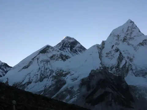
[Day 6-10: The Basecamp Run] Tengboche to Gorak Shep & EBC Summit (5,364 m)
[Day 11-14: The Return Track] Retracing steps back to Lukla & Kathmandu -(Rapid Safety Descent)
In fact, trying to "cut time" on the Everest Base Camp trek itinerary by squeezing it into fewer than 14 days is arguably the biggest blunder of trekking there. Do so and you exponentially increase your risk of Acute Altitude Mountain Sickness (AMS) and significantly decrease your probability of even reaching your goal. The 14-day EBC Trek itinerary gives you sufficient time for the human system to naturally adjust to the environment as you slowly make your way higher, ultimately enabling you to complete the expedition on sturdy legs and with clear lungs.
Why Two Weeks?
The Crucial Acclimatisation Window: Two dedicated, mandatory "rest days" (meaning no travel, just walking short distances in and around your lodge to stretch legs) are built into the 14-day schedule. This is critical in allowing your system to produce new red blood cells to cope with the diminishing oxygen levels, effectively preparing you for the most critical high-altitude points.
The Himalayan Buffer: Himalayan climate is notoriously volatile. If flights are cancelled from Kathmandu or Lukla, your two-week timeframe offers some breathing room and removes the added stress of being behind schedule.
Reasonable Trekking Hours: Each day on the trail is typically 5-7 hours of trekking. This means your body can perform adequately at altitude and still fully recover in your teahouse that evening.
Immersive Experience: With the added time, you are not simply rushing to reach Everest Base Camp. You have the opportunity to spend ample time exploring ancient Sherpa monasteries and soaking up local culture.
Trekking Phase
Standard Duration | Initial Trail Stage
Target Destination | Physiological Focus
Phase I: Low Valley Entry
Days 01-02 | Lukla Trailhead
Phakding to Namche | Gently stretching leg muscles, making your first big move to go over the 3000m line.
Phase II: Upper Valley Push
Days 03-07 | Namche Bazaar
Tengboche to Dingboche | Gradually and systematically gaining elevation, crucial adjustment phase for your blood composition.
Phase III: High Alpine Apex
Days 08-10 | Dingboche Hub
Lobuche to Gorak Shep / EBC | Ultimate, peak physical challenge. Navigating the difficult 5000m+ terrain and the vital Base Camp landmark.
Phase IV: Fast Escape Track
Days 11-14 | Gorak Shep Apex
Pheriche down to Lukla | Fast descent, immediately letting the body absorb a greater quantity of oxygen.
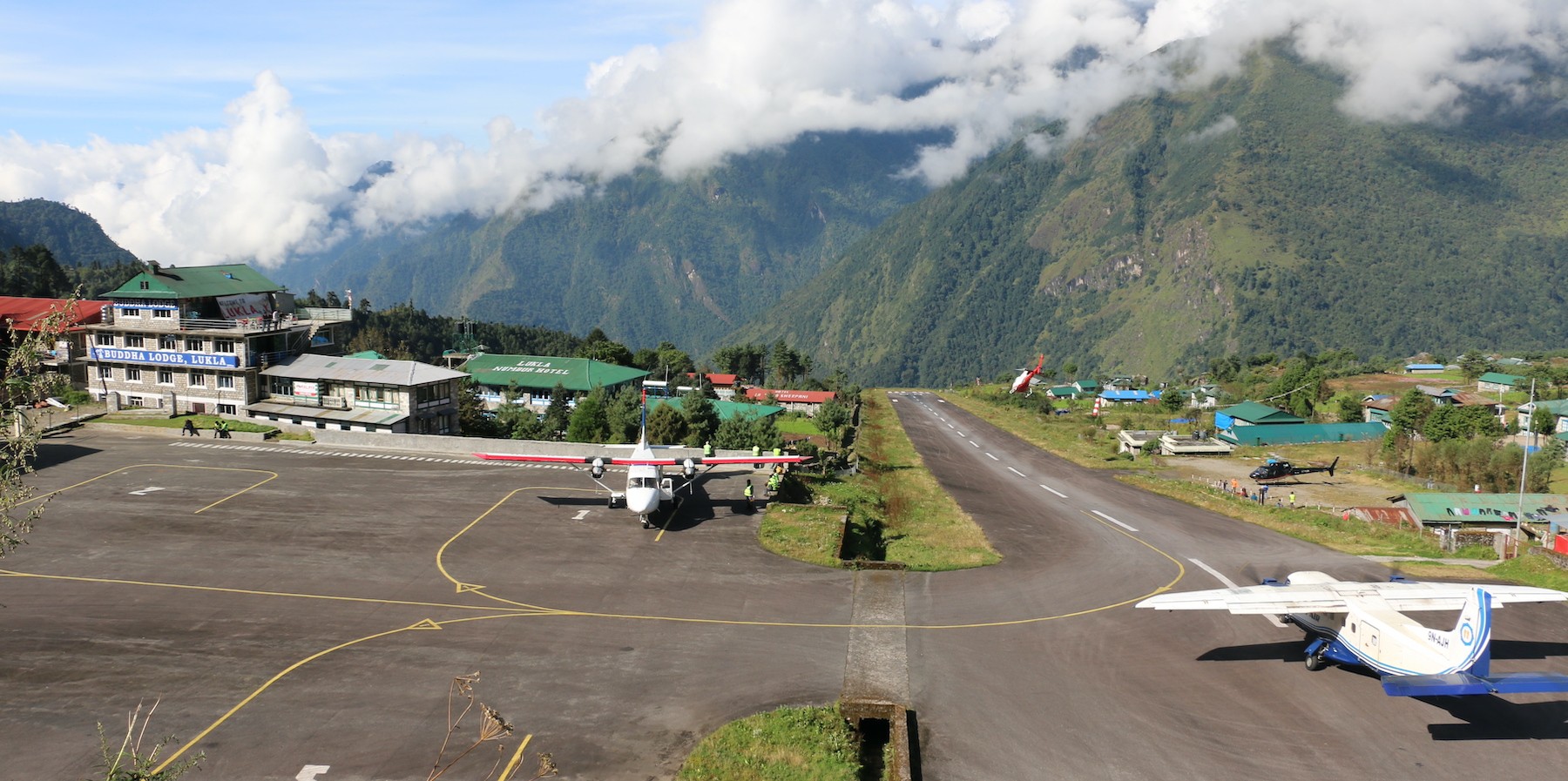
The Logistics Launchpad: Flying from Kathmandu/Ramechhap to Lukla Airport
Here, a spectacular aviation experience marks the start of your high-mountain adventure. To access the trailhead of your expedition, you'll need to catch a small, sturdy Twin Otter plane to land on a very steep mountain runway. Depending on your trek's date, you may be leaving directly from the Tribhuvan International Airport (TIA) domestic terminal in the capital, or you may be heading to a small rural airport an hour's drive outside of Kathmandu in the pre-dawn darkness to take off.
Lukla Airport – the thrilling gateway to Everest, where every Himalayan adventure begins. ✈️
Navigating the Lukla Gateway :
The seasonal shift: Between March and May (spring trekking season) and from mid-October to mid-December (autumn trekking season), flights are routinely diverted. They take off from the regional Ramechhap Airport (RHP), located 4 hours away from Kathmandu and requiring a 1:00 AM private transfer in order to make the early morning flight schedule.
The thrill ride: The flight from Kathmandu to Lukla takes approximately 35 minutes (and just 12 from Ramechhap); your flight will cut through immense, dramatic valleys and soon land on a steep upward slope known as the Tenzing-Hillary Airport.
The touchdown at the trailhead: Immediately after your short flight, you’ll be standing at the Lukla trailhead at 2,846 meters (9,337 feet), meeting up with your local trekking guides and porters, and finalising the distribution of trekking gear.
A downhill initial hike: Counterintuitively, you'll immediately start a hike downhill along the Dudh Koshi river, crossing large suspension bridges, on your way to Phakding for the night at an altitude of 2,610 meters (8,562 feet).
Transit
Kathmandu Domestic Terminal (KTM)
Manthali Airport, Ramechhap (RHP)
Pre-flight travel
20-30 minutes from central Thamel
4 to 4.5 hours via a private, midnight drive
Flight duration
Approximately 35 minutes
Just 12-15 minutes
Susceptibility to delays
High - prone to morning fog and airport congestion
Low - clearer weather, better traffic flow
Traveler comfort
Standard airport facility
Very basic; requires a challenging road trip
Transit Comparison: Kathmandu vs. Ramechhap
First Night Altitude Matrix: Lukla to Phakding
Lukla Tenzing-Hillary Airport :
Elevation: 2,846 meters (9,337 feet)
Net Altitude Shift: Starting Altitude
Oxygen Availability: Approximately 72% of sea-level
Path Surface: Paved stone walkways leading through the mountain marketplace
Cheplung Village Intersection :
Elevation: 2,660 meters (8,727 feet)
Net Altitude Shift: -186 meters (-610 feet)
Oxygen Availability: Approximately 74% of sea-level
Path Surface: Wide, dusty tracks passing small mani walls and stupas
Ghat Riverside Settlement :
Elevation: 2,590 meters (8,497 feet)
Net Altitude Shift: -70 meters (-230 feet)
Oxygen Availability: Approximately 75% of sea-level
Path Surface: Stone-paved trail tracing the banks of the glacial river
Phakding Lodge Baseline :
Elevation: 2,610 meters (8,562 feet)
Net Altitude Shift: +20 meters (+65 feet)
Oxygen Availability: Approximately 75% of sea-level
Path Surface: Pine-shaded, pine needle-strewn paths leading to the first lodges
First Night Sleep Safety Rule: Arriving at Lukla airport (2,846 meters) creates immediate, albeit minor, stress on the respiratory system. Sleeping at 2,610 meters in Phakding is a crucial, safety-oriented practice of the 14-day EBC itinerary. The brief initial drop provides a comfortable oxygenated zone for your system to recover from the flight before you ascend towards Namche Bazaar on day two.
Everest Base Camp Trek with Helicopter Fly Out 10 Days | 10 days
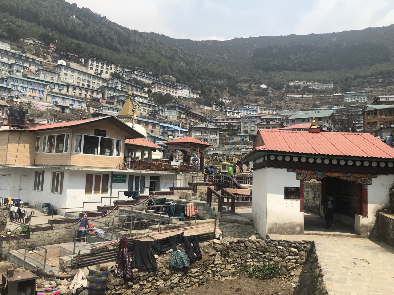
Entering Sherpa Territory: The Crucial Ascent to Namche Bazaar
Here, your second day on the trail represents your full entry into the realm of high altitude trekking. Following the raging Dudh Koshi River from Phakding you’ll walk through pine forests and small farming hamlets before arriving at Monjo – the entrance to Sagarmatha National Park where your permits will be checked. Here the easy, valley floor trekking will end, and the mountains begin to call for real.
Namche Bazaar – the heart of the Everest region, where Sherpa culture, mountain life, and adventure come together.
[Namche Bazaar Hub: 3,440 m] The Final Steep Pine-Forested Climb- (Larja Dobhan Incline: +600 Vertical Meters)
[Hillary Suspension Bridge: 2,840 m] The High Aerial Gorge Crossing- [Monjo Park Checkpoint: 2,835 m]
[Phakding Baseline: 2,610 m]
In fact, the biggest challenge of this segment begins where the Bhote Koshi and Dudh Koshi Rivers merge. You will see a pair of suspension bridges swinging high over the chasm, the bottom one abandoned to the elements, and the higher one the famous Hillary Suspension Bridge suspended a dizzying height above the raging water. Crossing the latter means you’ll be at the base of the steep climbing trail to Namche Bazaar, a taxing uphill grind that will test your lungs and legs.
Ascending the Entrance Hill :
The Gorge Crossing: Walking across the vibrating wire structure of the Hillary Suspension Bridge over the roaring water below is one of the most iconic aspects of this hike and an excellent opportunity to appreciate the sheer scale of the gorge.
The First Altitude Wall: As soon as you cross the bridge, the Namche Bazaar trail transforms from gentle river-level path to a seemingly endless staircase of rocks and dirt winding over 600 vertical meters through dense pine forests.
The First Summit Peak View: About halfway up the steep climb, if the sky is clear, you’ll reach a small platform off the main trail. It’s a perfect place to take a breather and get your first peek at Mount Everest rising over the tree line.
The Gateway to the Gods: The trees will finally fall away as you emerge onto a stunning amphitheater basin, home to the sprawling, horseshoe-shaped Sherpa capital of Namche Bazaar (3,440 meters / 11,286 feet), the legendary Gateway to Everest.
Trail Stage Breakdown: Phakding to Namche Bazaar
The River Flat Section :
Trail Landmark: Phakding to Monjo Gate
Distance: ~6.5 km
Vertical Elevation: +225 m
Physical Difficulty: Easy to Moderate
Gentle, well-maintained dirt paths with river stones underfoot.
The High Air Suspension Crossing :
Trail Landmark: Larja Dobhan (Hillary Bridge)
Distance: ~1.0 km
Vertical Elevation: +5 m
Physical Difficulty: Moderate
Narrow footing over a vast chasm with strong crosswinds.
The Forest Staircase Wall :
Trail Landmark: Hillary Bridge to Namche Entrance
Distance: ~3.5 km
Vertical Elevation: +600 m
Physical Difficulty: Strenuous
Continuous, steep uphill trek with no flat sections.
Success Factor of the Itinerary: The All-Important Namche Acclimatization Day
Actually, arriving at Namche Bazaar (3,440 meters) is a significant moment on your trek. At this altitude, the atmospheric pressure is about two-thirds that of sea level and your body will not have the ability to fully adjust to the oxygen deficit overnight. This is precisely why a 14-day trekking itinerary dedicates an entire day to rest and acclimatization right here.
Everest View Hotel – enjoy a meal with one of the most spectacular mountain panoramas in the world.
Quick Facts:
[Everest View Hotel Ridge: 3,880 m] (1-Hour Acclimatization Visit)- (Hike High: +440 m Ascent) (Sleep Low: -440 m Descent)
[Namche Bazaar Amphitheater: 3,440 m] Essential Night 3 and 4 Sleep Location
In fact, this rest day at Namche is not designed to be spent lounging around your teahouse; instead, it requires active recovery. Using a standard mountain strategy, you will stress your body with a carefully calibrated dose of high altitude throughout the day, then descend to a lower altitude to sleep. This process prompts your kidneys to release more erythropoietin (EPO) which in turn tells your bone marrow to produce more oxygen-carrying red blood cells. The Active Recovery Method :
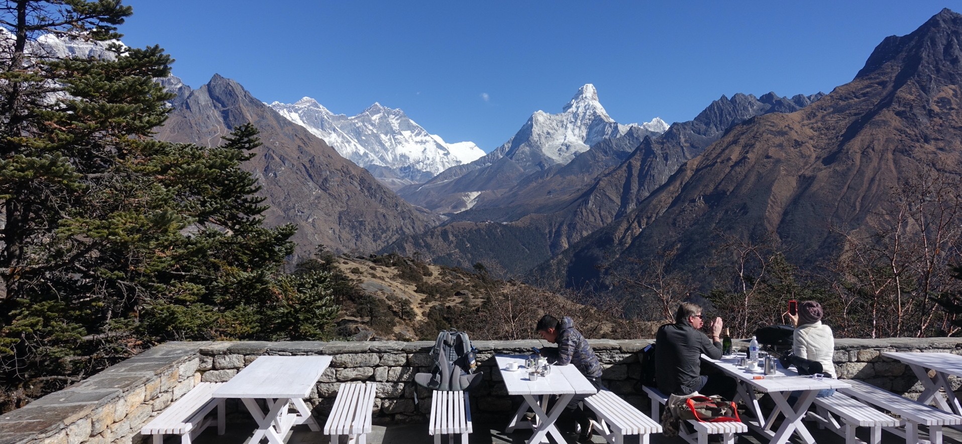
The Namche Climb to Shyangboche: The most common Namche acclimatization trek is a quick, steep climb out of town, ascending the stone steps above Namche to the grassy landing strip at Shyangboche.
The Hike High Sleep Low Protocol: The idea is to walk up to the ridge line at 3,880 meters ($12,730\text{ ft}$) and rest for an hour or two, then hike back down to Namche at 3,440 meters for the night.
The Panoramic Vista Reward: From the ridge top you’ll walk on a relatively flat trail towards the famous Everest view hotel day hike, where you can sit with a warm drink and see Mount Everest, Lhotse and Ama Dablam spread across the horizon.
The Safe Return: Trekking back down to Namche for your second night allows your body to continue the recovery process in the more oxygen-rich environment and primes it for the higher altitudes to come.
Namche Acclimatization Hike Comparison: Bowl vs. Ridge
Everest View Hotel (Hike High Ridge): 1 to 2 Hours (Brief recovery, observation, and breathing in thin air)
Cardiovascular Exertion Level :
Namche Bazaar (Sleep Low Base): Low; relaxation in warm teahouse dining rooms and easy strolls around the market.
Everest View Hotel (Hike High Ridge): Moderate to High; steep stone steps require strong lung capacity.
The Slow Pace Rule of Acclimatization: Regardless of how strong you may feel, stick to the advice of your guide: "Bistari, bistari." Rushing to the Everest View Hotel will not boost your acclimatization; instead, keep your heart rate at a low, steady rhythm, wear light layers to regulate your body temperature, and make an extra effort to stay hydrated by drinking at least a liter more water than usual.
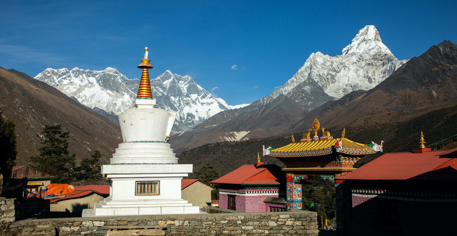
Spiritual milestones: trekking through the holy Tengboche monastery
Just imagine standing at a place in Everest region where ancient spirituality is interlaced with awe-inspiring Himalayan views. The trek from Namche to Tengboche offers just that and is one of the most magical aspects of the Everest Base Camp trek, offering nature, culture and serenity in one satisfying experience. You will descend from Namche Bazaar through pine forests towards Phunki Tenga at 2,860 m (9,383 ft). From here, it is a rewarding, steep climb through rhododendron groves towards the holy Tengboche Monastery perched at 3,860 m (12,664 ft).
Tengboche – a spiritual Himalayan sanctuary where breathtaking mountain views meet rich Buddhist heritage.
Actually, this part of the trek is remarkable because of the perfect mix between a physical challenge and spiritual awareness. The path from Namche to Tengboche gradually unwraps the profound Buddhist culture of the Khumbu region. You will cross suspension bridges and enjoy the gradually unfolding Khumbu panorama with the majestic Ama Dablam looming at 6,812m (22,349 ft). The Tengboche monastery hike truly stands out and makes for a profoundly fulfilling trek segment. Tengboche monastery: spiritual significance :
One of the most prominent Buddhist monasteries within the Everest region
Established in 1923 with a deep history; rebuilt after a fire
A truly peaceful and meditative environment ideal for introspection and prayer
Monks at the monastery chant traditional mantras and perform rituals for guests
A powerful symbol of Sherpa culture and the spiritual nature of the Himalayas
Namche to Tengboche: trail highlights :
Descent through dense pine and rhododendron forests to Phunki Tenga
A rewarding, steep climb through vibrantly coloured spring rhododendrons
Multiple suspension bridges over the powerful glacial rivers flowing through the valley
The panoramic view of the Khumbu region slowly revealing itself
Incredible photographic opportunities with the imposing backdrop of Ama Dablam
Trail section
elevation
key highlights | walking time
Namche to Phunki Tenga
Descent to 2,860 m (9,383 ft)
Forest paths and river crossing | 2-3 hours
Phunki Tenga to Tengboche
Ascent to 3,860 m (12,664 ft)
Rhododendron climb and monastery visit | 3-4 hours
Tengboche Exploration
3,860 m (12,664 ft)
Panoramic views and monastery grounds | 1-2 hours
Tengboche monastery trail details :
Advantages of the Tengboche hike :
Deeply spiritual component that enriches your Everest Base Camp trek.
An excellent phase for altitude acclimatisation before proceeding higher.
Unforgettable memories of the vibrant local culture and dramatic landscapes.
A period of calm and reflection within the awe-inspiring mountain range.
In essence, the trek to the holy Tengboche Monastery from Namche serves as a magnificent spiritual peak on your Everest Base Camp journey, combining breathtaking scenery, rich culture, and deep tranquility into an unforgettable experience. To make sure this sacred pilgrimage is part of your bespoke Everest Base Camp trek package, please contact Haven Holidays today.
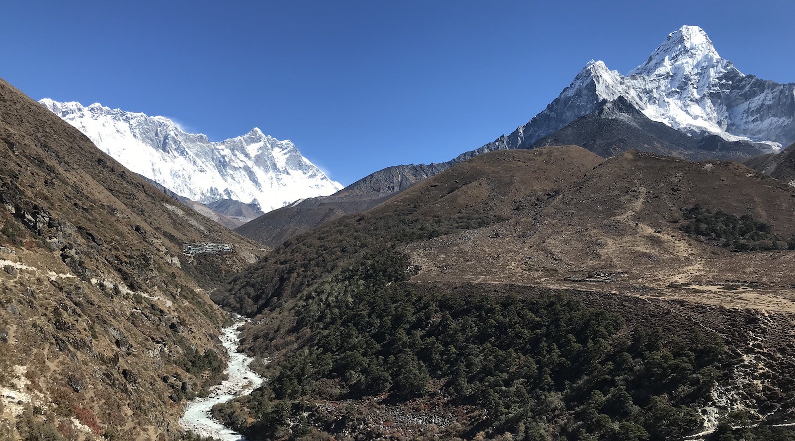
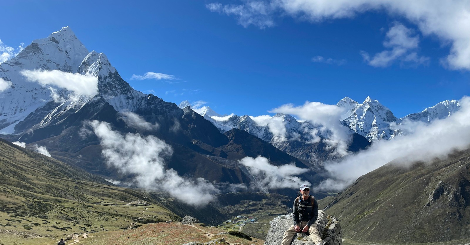
Entering the high valley: onward to dingboche outpost
Here, feel the terrain drastically shift and the last vestiges of trees fade into the vast, raw alpine wilderness. This stage on the Everest Base Camp trek is where you truly enter the realm of high altitude adventure. After Tengboche, you will make your way toward Dingboche village, traversing through Pangboche and crossing the Imja Khola before ascending into the expansive Imja Valley to reach Dingboche at an altitude of 4,410 m (14,469 ft).
On the way to Dingboche – where rivers, valleys, and towering Himalayan peaks create an unforgettable trekking experience.
Likewise, the striking transformation of the landscape to high-altitude terrain brings you face-to-face with towering giants and exposed terrain subject to strong mountain winds. Stone-walled terraced fields and humble potato crops stand as a testament to human resilience and ingenious adaptation. Dingboche is a perfectly located and comfortable acclimatisation outpost that is equipped with a good network of teahouses. It significantly builds both your stamina and your confidence before the ultimate ascent.
Dingboche village route: characteristics :
Clear transition from forested slopes to open, wind-swept high-altitude valleys
Crossing the Imja Khola river just after the village of Pangboche
Unique, resilient dry-stone agricultural terraces clinging to steep slopes
A raw, wild landscape defined by strong winds and unobstructed vistas
Increasingly closer views of Lhotse, Island Peak, and neighbouring mountains
High-altitude landscape shift: features :
vegetation transitions from pine and rhododendron to low-lying shrubs and hardy grasses
dramatic, exposed rocky slopes and glacial moraines
the harsh yet beautiful environment that tests and strengthens trekkers
uninterrupted and dramatic views of major Himalayan peaks
an ideal location for acclimatisation hikes and photography
Trail segment
Elevation change
landscape feature | walking time
Tengboche to Pangboche
3,860 m to ~3,985 m (13,074 ft)
forest thinning to open valley with views | 2-3 hours
Pangboche to Dingboche
ascent to 4,410 m (14,469 ft)
Imja Khola crossing and terraced fields | 3-4 hours
Dingboche Acclimatization
4,410 m (14,469 ft)
high-altitude farming and peak vistas | rest days
Trail to Dingboche: detailed overview :
Advantages of a Dingboche stop :
An excellent base for rest and restorative acclimatization hikes
Critical for preventing and managing altitude sickness at higher elevations
Drovides a glimpse into traditional, challenging high-altitude agriculture
Immerses you in the true essence of the rugged Himalayan wilderness
Prepares your body and mind for the demanding final stages of the trek
In conclusion, the trek to Dingboche from Tengboche outpost signifies a truly exciting shift in your Everest Base Camp journey, deepening your connection with the Himalayas and laying the groundwork for the challenging days ahead. Book your comprehensive Everest Base Camp trek package with Haven Holidays and experience every single transformative segment on this iconic trail.
Success factor 2: The strategic second rest day in Dingboche
Find out why the second rest day in Dingboche often determines success on the Everest Base Camp trek. The strategic stop at 4,410 m (14,469 ft) allows you to acclimate properly, greatly reducing the chance of altitude sickness, and prepare your body for the days at higher altitudes ahead. Many trekkers on a shorter itinerary skip this day, which proves detrimental later in the trek. Therefore, a well-planned Dingboche acclimatization strategy helps ensure that you reach the Everest Base Camp both safely and without any major trouble.
Dingboche – the jewel of the Imja Valley, surrounded by some of the most magnificent peaks in the Everest region.
Actually, the beautiful valley that Dingboche is nestled in is surrounded by awe-inspiring peaks. You utilize the rest day to both rest and undertake a highly rewarding day trek up to Nangkartshang Peak (5,083 m/16,677 ft). Climbing up this peak and returning for the night to sleep lower down in Dingboche, is a perfect way to gain altitude efficiently while not causing your body to suffer too much of a shock. From the top of Nangkartshang, you also gain some spectacular views of some of the world's highest peaks such as Ama Dablam and Makalu, which is another positive aspect of this acclimatization hike.
Dingboche acclimatisation strategy - benefits :
Allows your body to gradually adapt to the high altitude of 4,410m (14,469ft).
Greatly reduces the chances of developing Acute Mountain Sickness (AMS).
Allows your body a much-needed day of rest and recovery.
Helps to build the confidence and physical stamina needed for the climb ahead.
Serves as a much-needed buffer day before you cross higher altitudes.
Nangkartshang peak day hike - highlights :
Steady climb to 5,083m (16,677 ft) rewarding you at every step.
Panoramic views of several 8000m peaks.
Good way to prepare your body for further trekking at higher altitudes.
A perfectly guided day hike from Dingboche village.
A great test for your body and tolerance to high altitude.
Why skipping the Dingboche rest day leads to failure :
Your risk of suffering Acute Mountain Sickness is far greater as you ascend quickly to higher altitudes.
You are not giving your body enough time to produce additional red blood cells needed at higher altitudes.
Your upper body will be considerably more fatigued and you will probably have a much lower enjoyment of your trek to Base Camp.
This often leads to early turnarounds when trekkers are on rushed itineraries.
All 14 day guided schedules for Everest Base Camp include this rest day for a reason.
Activity
Altitude
Purpose | Duration
Rest and gentle walk in Dingboche
4,410 m (14,469 ft)
Recovery and easy movement | 1-2 hours
Day hike to Nangkartshang Peak
up to 5,083 m (16,677 ft)
Sleep low climb high principle | 5-7 hours
Relax in Dingboche
4,410 m (14,469 ft)
Relax and prepare for next day | Free time
Sample Day on acclimatisation day :
In conclusion, this strategic second rest day, and day hike to Nangkartshang Peak in Dingboche, plays a vital role in guaranteeing that you have a successful trek to Everest Base Camp. It helps to avoid altitude sickness and enhances your enjoyment of the journey. Book a 14 day guided Everest Base Camp trek through Haven Holidays today.
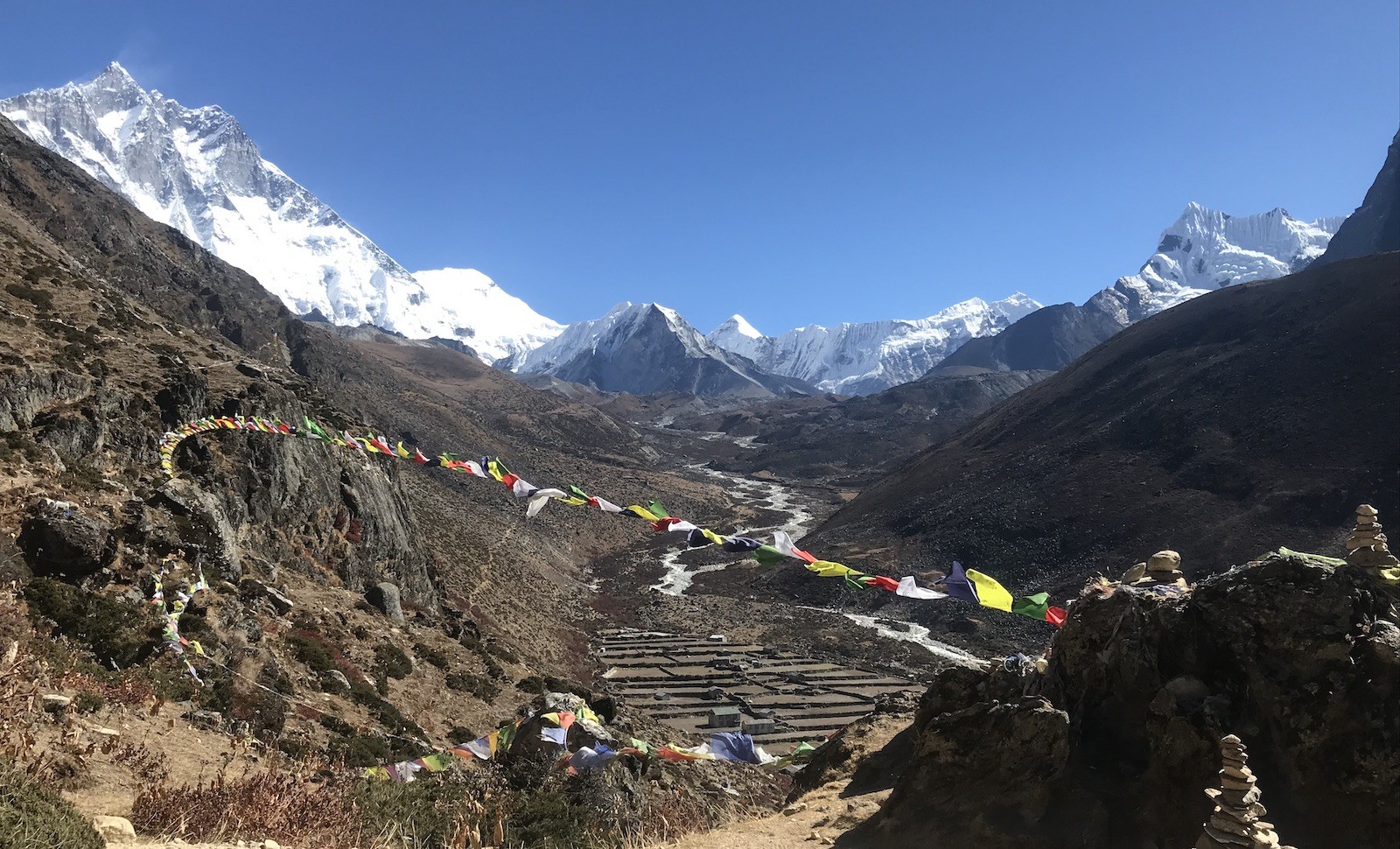
Walking Past Legends; the climb from Thukla Pass to Lobuche
Here, you walk past the legends on an emotional and physical climb from Dingboche to Lobuche. The segment from Dingboche to Thukla Pass is an emotional part of the trek as you walk up through countless memorial stones and chortens built to remember people lost trekking to the highest mountain on Earth and other peaks.
The alpine valleys of Pheriche – a breathtaking high-altitude world of glaciers, rivers, and majestic Himalayan mountains.
Actually, the Thukla Pass is at 4,830 m (15,846 ft) and the entire path is lined with these memorial pieces, making it an extremely emotional and reflective part of your trek. After passing through the memorials, you then descend to follow the Khumbu Glacier’s rocky moraine edge, which takes you to Lobuche at 4,910 m (16,109 ft). This section is rocky, and demands full focus from the trekker, but is definitely rewarding for you both physically and emotionally.
The memorials at Thukla Pass :
This climb is up to 4,830 m (15,846 ft)
Memorials line the path, in memory of deceased climbers.
An extremely poignant and emotional part of your Everest Base Camp journey.
offers some truly incredible mountain views.
Arrival at Lobuche village :
A village located at 4,910 m (16,109 ft).
Basic teahouses are available for trekkers.
A stopping point closer to the Khumbu Glacier and Base Camp.
An out of this world landscape due to it's surroundings, featuring glaciers and sharp rocks.
Trail
Altitude
Notable features | Walking time
Dingboche to Thukla Pass
Up to 4,830 m (15,846 ft)
Climbing pass with memorials | 3-4 hours
Thukla Pass to Lobuche
Up to 4,910 m (16,109 ft)
Rocky Khumbu Glacier moraine | 2-3 hours
Trail to Lobuche :
A journey that is both physically and emotionally fulfilling :
Challenges your mind and body through the steep inclines.
Creates an invaluable connection to the pioneers of Everest climbing.
Prepares you physically for even higher elevations to come.
Truly unforgettable and inspiring part of your journey to Everest Base Camp.
In conclusion, the segment of your Everest Base Camp trek from Thukla Pass to Lobuche is perhaps the most emotionally charged of the whole journey. The physical and emotional demands make this an exceptionally rewarding and memorable experience. Book a guided trek today through Haven Holidays to experience it yourself!
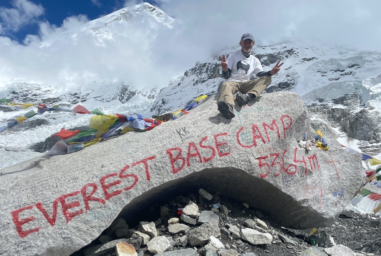
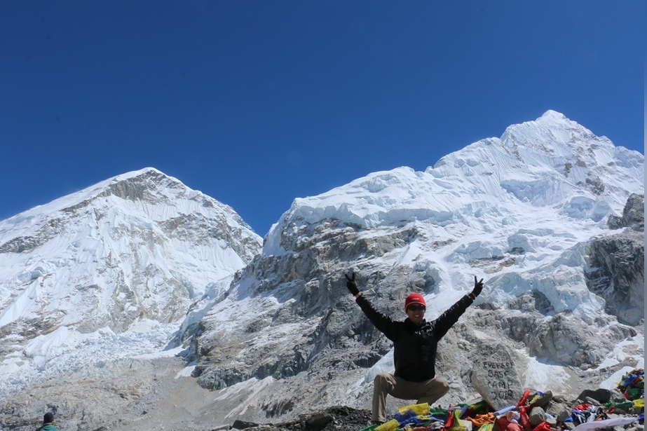
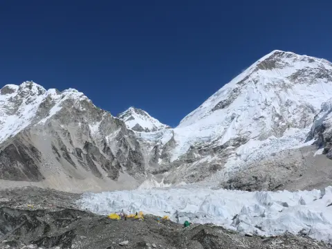
Standing at the Destination: Reaching Gorak Shep and Everest Base Camp
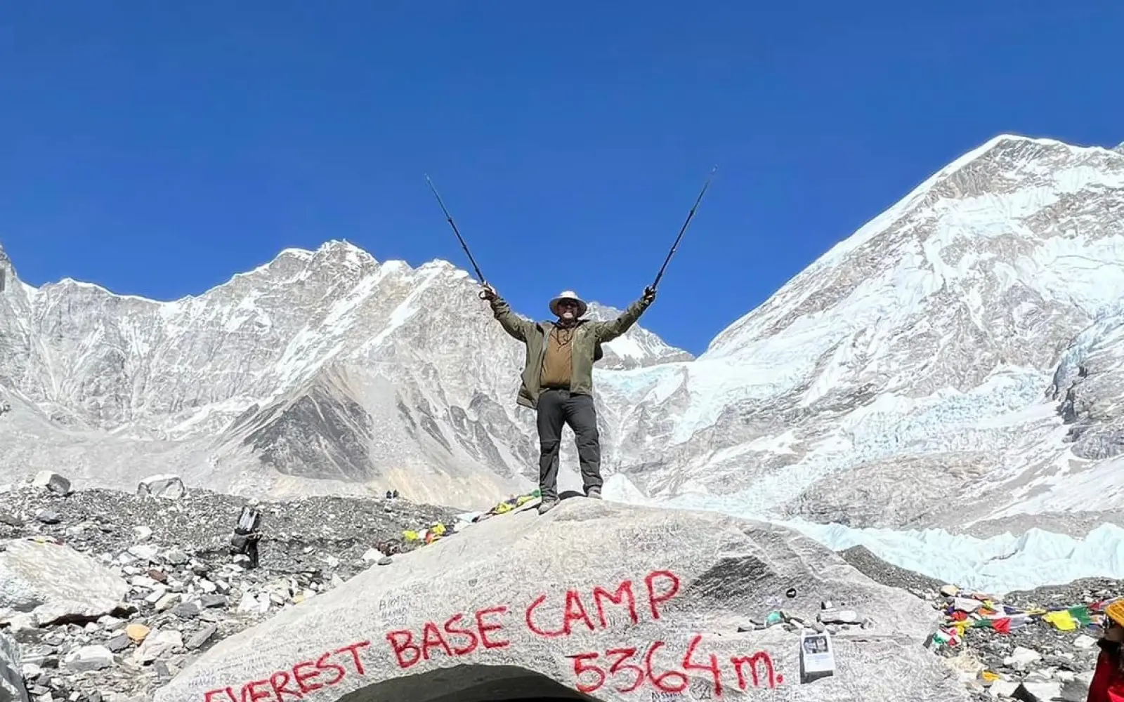
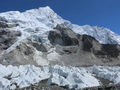
Here, the anticipation will build until you are standing at the base of the world's highest mountain. Gorak Shep and Everest Base Camp are the ultimate destination of this trek. After hiking up the rolling, rocky path to Gorak Shep, the final settlement at 5,164 m (16,942 ft), you'll push on across the glacier towards the official marker for Everest Base Camp at 5,364 m (17,598 ft).
Everest Base Camp – the iconic rock that marks the achievement of a lifetime beneath the world's highest mountains.
Likewise, this is the monumental day and will certainly test your endurance but will reward your efforts with an incredible sense of accomplishment. The path from Lobuche to Gorak Shep consists of bleak moraine with dazzling glacier views to one side of the path. The trail from Gorak Shep to Everest Base Camp is electrically charged, as you traverse across the Khumbu glacier itself, the experience of standing at Everest Base Camp will be one that every trekker remembers for life.
Gorak Shep Final Outpost :
The final settlement and the last night of your overnight stay in the EBC trek (5,164 m/16,942 ft)
Basic tea houses offer relatively simpler, but still comfortable facilities.
Starting point for trekking to EBC and also to the famous viewpoint, Kala Patthar
Stark and rocky terrain due to extreme high-altitude.
Excellent for your bodies' acclimatization before the final journey to Everest Base Camp.
Everest Base Camp :
Located at 5,364 m (17,598 ft) in elevation, this is the base of Mount Everest
The surroundings are awe-inspiring with giant icefalls and towering mountains
It truly is standing at the gateway to Mount Everest
Incredible photo opportunities abound, with prayer flags, snow-capped peaks, and glaciers forming a striking backdrop
This is the pinnacle moment of the entire EBC trekking experience
Itinerary
Altitude
Description | Time
Lobuche to Gorak Shep
To 5,164m (16,942ft)
Rocky undulating moraine path | 3-4 hrs
Gorak Shep to EBC
To 5,364m (17,598ft)
Shifting ice and rock glacier | 2-3 hrs
EBC to Gorak Shep
Return to 5,164m
Same trail, generally a quicker descent | 2-3 hrs
Gorak Shep to EBC Day Plan :
Significance of This Day :
This is the culmination of weeks of intense training and trekking
You connect directly to the ongoing efforts of Everest climbers
You feel a surge of pride and self-confidence
Unforgettable memories will be created that will last a lifetime
In conclusion, standing at Everest Base Camp after trekking from Gorak Shep provides an unparalleled feeling of triumph. It's a challenging yet ultimately achievable goal that rewards your dedication with the raw beauty of the Himalayas. Contact Haven Holidays today to book your guided Everest Base Camp trek and experience this once-in-a-lifetime destination!
The Ultimate Sunrise Viewpoint: Scaling the Summit of Kala Patthar
Before the sun even rises, you will begin to ascend toward what is arguably one of the most breathtaking viewpoints in the Himalayas. Climbing Kala Patthar is the most rewarding Everest Base Camp trek viewpoint, offering the most spectacular sunrise views. After hiking up the steep incline in the pre-dawn dark, you will reach the summit of Kala Patthar, a peak sitting at 5,545 m (18,192 ft), making it the highest point you will reach in the entire EBC trekking journey.
Sunrise over Everest – a magical moment as the world's highest peak glows in golden morning light.
Actually, the actual Everest Base Camp (5,364 m / 17,598 ft) does not allow you to directly view the entire Mount Everest summit because it's tucked away in a low-lying valley, so you have to make your way up the Kala Patthar peak in order to catch the most unobstructed view of Mount Everest (8,848m / 29,029ft), as well as Nuptse and Lhotse. The pre-dawn hike to the summit is quite magical, as the first light will begin to streak across the sky, and the peak of Mount Everest, as well as its neighboring peaks, will slowly turn from the dull gray of the night to a vibrant golden-pink color. The Mount Everest sunrise photographs taken from this vantage point have to be some of the most iconic in all the Everest Base Camp trek.
Kala Patthar climb Advantages :
It is the highest point in the EBC trek at 5,545m / 18,192ft
Provides unhindered, complete views of Mount Everest summit
An ideal time to capture stunning sunrise photos
The trail to the summit is straightforward, albeit steep
Get clear views, especially when you reach it before the sun is high in the sky
Why Kala Patthar Viewpoint is Crucial :
EBC itself lies in a valley, making Everest views obstructed.
Incredible panoramic views of all of the tallest mountains in the world.
The experience of saying "I stood above Everest Base Camp" creates unforgettable memories.
The most satisfying moment and photo collection point of your trek.
Offers immense satisfaction for achieving the highest point.
Itinerary
Altitude
Difficulty | Time
Gorak Shep to Kala Patthar
To 5,545m / 18,192ft
Steep slope, pre-dawn start | 2-3 hrs
Kala Patthar Summit
5,545m / 18,192ft
Sunrise viewing and photography | 30-60 mins
Kala Patthar to Gorak Shep
Back to 5,164m
Easier downhill return | 1.5-2 hrs
Kala Patthar Summit Climb :
Photography and Enjoyment Tips :
You will want to wear a headlamp and bring multiple layers of clothing to keep warm, especially in the freezing morning temperatures.
You should aim to get there early to get a good spot, especially if you want the perfect sunrise picture.
Take plenty of pictures, you won’t want to forget this moment!
Soak in the incredible satisfaction of conquering the EBC trek’s highest elevation.
In conclusion, climbing to the summit of Kala Patthar is a magical moment that perfectly caps off your Everest Base Camp trek. This pre-dawn adventure promises unparalleled mountain vistas. Book your full guided trek with Haven Holidays today and witness the breathtaking beauty of Mount Everest from Kala Patthar!
The Quick Decline: Returning Safely down the Valley, through Pheriche to Namche
Once you have stood at the highest base camp on Earth and witnessed the sunrise paint the jagged ridge of Kala Patthar, the trek officially begins its homestretch. This is the rapid EBC trek return route, a fast- paced scramble back down the valley. Due to your body's recent hyper- production of red blood cells to combat oxygen deprivation above 5,000 m (16,400 ft), the decline feels like walking into an incoming tide of energy.
Pheriche Valley – where magical clouds dance across the Himalayan landscape beneath towering mountain giants.
[Gorak Shep Apex: 5,164 m] (Sharp drop in altitude: -793 m) [Pheriche Flat Valley: 4,371 m] Breathing becomes easier, oxygen thickens (Forest & River Walk: -511 m) [Tengboche Ridge: 3,860 m] (Final Push: -420 m) [Namche Bazaar Bowl: 3,440 m] lungs relieve and showers abound
The focus of this stage is fast-track downhill trekking. In one afternoon you will accomplish in walking distance what took two days to ascent. As the landscape morphs from dry alpine slopes back to wide, wind-battered alpine meadows, you arrive at the valley floor of Pheriche at 4,371 m (14,340 ft). With every hour that passes your lungs feel less strained, your sleep deepen and muscles recover.
The return trip's mechanics:
Descend through Pheriche: From the high moraines near Lobuche, the trail turns south. Bypassing Dingboche completely, it winds down into the open, rolling meadows of Pheriche at 4,371 meters (14,340 ft). This low valley floor provides immediate relief from the biting wind and cold found higher up on the plateau.
The Oxygen-freefall boost: Descending below the 4,500-meter (14,760-ft) altitude mark provides an almost instantaneous return of clarity to your head. Your lungs begin to work normally without conscious effort, and overall energy levels jump.
Long, safe treks down: Because the descent demands so little lung work compared to climbing up, you can safely trek for 15–20 kilometers a day as you trace your path back through Pangboche and Tengboche, arriving at Namche Bazaar very quickly.
Protect your knees and ankles: While the descent is much less taxing on your lungs, the repeated impact can place considerable strain on your lower joints. Keep your knees slightly bent and use your trekking poles for stability and to absorb impact from each downward step.
Downhill trekking differences in terrains: Average Walking Speed :
High Moraines (Lobuche to Pheriche): 2.0 – 2.5 km/h (1.2 – 1.5 mph); requires careful, focused footing on the loose shale and rocks.
Lower Valleys (Pheriche to Namche): 3.5 – 4.5 km/h (2.2 – 2.8 mph); allows for steady strides on well-established, dirt paths.
Lung Effort :
High Moraines (Lobuche to Pheriche): Slight to moderate; some mild breathlessness during short inclines.
Lower Valleys (Pheriche to Namche): Low; comfortable, regular breathing in the thickening air.
Joint and Muscle Strain :
High Moraines (Lobuche to Pheriche): High; Ankle and balance strain from navigating uneven terrain.
Lower Valleys (Pheriche to Namche): High; Quadriceps and knee strain from the downward motion.
Temperature and Environment :
High Moraines (Lobuche to Pheriche): Extreme, freezing wind, very dry, barren, rocky environment.
Lower Valleys (Pheriche to Namche): Mild breeze, comfortable, and temperate, surrounded by pine forests.
Conclusion: The Case for the 14-day itinerary-why it's the best decision
To cut a few days off of your trekking to the world's highest peak is a highly dangerous compromise. Rushed 10-11-day itineraries offered by commercial outfitters, often forgoing the necessary rest days at Namche or Dingboche, are the primary cause of failure and med-evacs. Planning for a 14-day optimum acclimatization itinerary is hands-down the safest, surest way to make your trek successful. The schedule aligns itself with your body's natural chemistry, insuring a higher success rate and a completely enjoyable experience. Study this detailed EBC trek itinerary summary to plan your trip.
Itinerary Day & Trekking Location
Altitude (m) / (ft)
Daily Distance | Walking time (Hours) | Trekking Style and Focus
Day 1: Fly into Lukla, trek to Phakding
2,610 | 8,562
7.8 km | 3-4 | Gentle walk along the river.
Day 2: Phakding to Namche Bazaar
3,440 | 11,286
10.5 km | 5-6 | Significant uphill trek through rhododendron forests.
Day 3: Acclimatization Rest in Namche Bazaar
3,440 | 11,286
4.5 km | 2-3 | Active rest day. Hike to Everest View Hotel (3,880 m).
Day 4: Namche to Tengboche Monastery
3,860 | 12,664
9.2 km | 5-6 | Pleasant ridge walks with a short downhill descent to the monastery.
Day 5: Tengboche to Dingboche
4,410 | 14,468
10.8 km | 5-6 | Moving out of the forests and into wider valleys.
Day 6: Acclimatization Rest in Dingboche
4,410 | 14,468
5.0 km | 3-4 | Mandatory hike to Nangkartshang Peak (4,960 m).
Day 7: Dingboche to Lobuche
4,910 | 16,108
8.5 km | 5-6 | Steady climb to Lobuche, passing the Everest memorial at Thukla Pass.
Day 8: Lobuche to Gorak Shep and Everest Base Camp
14.5 km | 6-7 | Early morning ascent of Kala Patthar for sunrise, then a rapid descent to Pheriche.
Day 10: Pheriche to Namche Bazaar
3,440 | 11,286
18.2 km | 6-7 | Fast-track downhill walking through forests.
Day 11: Namche Bazaar to Lukla
2,846 | 9,337
18.3 km | 7-8 | Final long downhill day to the trailhead at Lukla.
Day 12: Fly Lukla to Kathmandu / Ramechhap
1,400 | 4,593
N/A | 35 min | Mountain flight back to the city.
Day 13: Reserve Day in Kathmandu
1,400 | 4,593
N/A | N/A | A full rest day in case of Lukla flight delays.
Day 14: Departure
N/A | N/A
N/A | N/A | Final pack up and transfer to the airport.
The Complete 14-day EBC trek Reference Chart :
A Professional's Word of Advice: Before booking your Everest Base Camp trek, pay close attention to the day-by-day itinerary of your guiding company, not just the price tag. A reputable operator will never skimp on the mandatory rest days in Namche Bazaar or Dingboche, and instead opt for the optimal 14-day trek that will allow you to reach Everest Base Camp safely.
In conclusion, choosing the best itinerary for Everest Base Camp trek planning is the most important choice that any trekker would make. With an appropriately phased plan, trekkers can comfortably acclimatize while trekking the most dramatic mountain trails in the world.
Island Peak Climb with Everest Base Camp Trek | 21 days
1. Why is a 14 day itinerary the best itinerary for Everest Base Camp trek? The 14-day itinerary is the best itinerary for Everest Base Camp trek because it includes vital acclimatization days. The acclimatization breaks prevent any risk of Altitude Sickness, and allow you to enjoy the highest altitude mountain ranges with ease.
2. Where does the Everest Base Camp trek itinerary officially commence? The conventional Everest Base Camp trek itinerary begins at the Tenzing-Hillary Airport in Lukla (2,860m) after a captivating flight from Kathmandu. From Lukla, the actual walking trail descends into the deep river valley until Phakding where the first overnight stay occurs.
3. How many miles does a complete Everest Base Camp trek route traverse? A total of 130km or 80 miles makes up the round trip Everest Base Camp trek route. You will walk approximately 10-15 km on an average per day at a steady pace.
4. What is the highest altitude on the standard Everest Base Camp trek itinerary? The apex geographic point on any typical Everest Base Camp trek itinerary is Kala Patthar, situated at a height of 5,550m (18,208ft) that overlooks the Everest Base Camp itself. The Base Camp footprint lies slightly down the glacial valley at an elevation of 5,364m.
5. Why two acclimatization stops on the Everest Base Camp trek route? Two acclimatization stops are an integral component of the well designed Everest Base Camp trek route. They serve a critical purpose of helping the body slowly adapt to the atmospheric changes at high altitudes. This makes them crucial on your trek in the Himalayas.
6. Describe the first difficult ascent along the Everest Base Camp trek itinerary. The trek begins with a rigorous vertical hike to Namche Bazaar. It follows crossing the high suspension bridge of Hillary after which you must conquer an imposing, steep 700m dirt path which demands every bit of physical effort from you.
7. What cultural and natural attractions lie on the Everest Base Camp trek route? The Everest Base Camp trek route passes through several fascinating cultural and natural attractions including the vibrant Sherpa capital of Namche Bazaar, the historical Tengboche Monastery, the climbers memorials at Thukla Pass, and the vast Khumbu Glacier with its immense, creaking presence.
8. Is a 10-day Everest Base Camp trek itinerary safe? No, a 10-day Everest Base Camp trek itinerary is quite fast and highly increases the chances of contracting Altitude Sickness. A minimum 12-14 day itinerary is the safest option to let your body recover, rest and acclimatize sufficiently to the terrain.
9. How difficult is the Everest Base Camp trek route in its final approach? The last few kilometers to the Everest Base Camp from Gorakshep or Lobuche are one of the most challenging segments of the entire trek. This part consists of an arduous, rocky, upward path with scree, glaciers and an overwhelming moraine wall that will drain you both physically and mentally.
10. What is the 'climb high, sleep low' technique adopted on the Everest Base Camp trek route? The 'climb high, sleep low' concept is the key training principle for any standard Everest Base Camp trek itinerary. You trek to an higher elevation in the daytime, then descend to a lower altitude in the evening and sleep there overnight, which boosts red blood cell generation.
11. Can my Everest Base Camp trek itinerary bypass trekking back to Lukla? Yes, you can opt to customize your Everest Base Camp trek itinerary into a lavish heli out variation. This premium package permits you to trek only up to the Everest Base Camp over 9 days. Thereafter, you will board a scenic helicopter back to Kathmandu.
12. What mountain is the summit that is ascended for the greatest vistas on the Everest Base Camp trek route? Climbing Kala Patthar for the most impressive views of Mount Everest is the highlight on most standard Everest Base Camp trek itinerary. Trekkers often embark on this steep climb very early in the morning to witness the magical spectacle of the sun kissing the Himalayan peaks.
13. How long do trekkers linger at the actual Everest Base Camp? Trekkers often linger at the Everest Base Camp only for about 30-60 minutes to capture the moments. They can hardly walk around since there are no teahouses at the Base Camp footprint. The journey back to Gorak Shep takes up much time and effort.
14. What type of lodging is on offer along the Everest Base Camp trek route? All trekkers lodging on the Everest Base Camp trek route stays in local family run teahouses. All teahouses on this trail are double sharing, contain two single beds. They have separate common dining halls where most of the food is served.
15. How must I train my body for the Everest Base Camp trek itinerary? Focusing on building endurance will greatly aid you in traversing the terrain of your Everest Base Camp trek itinerary. Start jogging or cycling and also participate in hiking with weighted backpacks 2-3 months before your departure.
16. Which permits are essential to finish the Everest Base Camp trek route? Two main permits are required to complete the Everest Base Camp trek route. These are the Khumbu Pasang Lhamu Rural Municipality Permit and Sagarmatha National Park Entrance permit, both arranged by the tour operator.
17. What is the finest time for my Everest Base Camp trek itinerary? The ideal months for scheduling your Everest Base Camp trek itinerary are from March to May and from September to November. This period is considered to have pleasant climate and stunning clear views.
18. How much more cash should I carry for the Everest Base Camp trek route? Besides the pre-paid tour price, carry at least NPR 40,000 to NPR 60,000 per person in cash. The teahouses do not accept card payments for daily expenditures like warm showers, battery charging, internet and purified water along the Everest Base Camp trek route.
19. Why is weather at Lukla crucial for the Everest Base Camp trek itinerary? Lukla Airport is famous for being unpredictable due to rapid mountain climate changes which can indefinitely delay your flight. The best itinerary for Everest Base Camp trek plans a few buffer days to avoid missing your onward flights in the event of unavoidable delays.
20. What is the typical success rate for a 14 day Everest Base Camp trek route? Fact to consider: The general success rate of the standard 14 day Everest Base Camp trek route is roughly 85 to 90 percent. If any trekker fails, they fail to complete their trek in a shorter itinerary due to their physical inability to adjust to the extreme heights.