[{"name":"Everest Base Camp Helicopter Tour","duration":"1","image_url":"https:\/\/www.havenholidaysnepal.com\/storage\/trip-galleries\/1\/thumb_6cd53005d75a86e373d31419d1b14d78.webp","offer_price":1195,"url":"https:\/\/www.havenholidaysnepal.com\/trips\/everest-base-camp-helicopter-tour"},{"name":"Everest Mountain Flight","duration":"1","image_url":"https:\/\/www.havenholidaysnepal.com\/storage\/trip-galleries\/4\/thumb_3b0b4f1d6f72b0ad224daf4752f2c6e0.jpg","offer_price":285,"url":"https:\/\/www.havenholidaysnepal.com\/trips\/everest-mountain-flight"},{"name":"Everest Short Trek","duration":"9","image_url":"https:\/\/www.havenholidaysnepal.com\/storage\/trip-galleries\/5\/thumb_BXPP3621.JPEG0.02033800 1727957098.webp","offer_price":895,"url":"https:\/\/www.havenholidaysnepal.com\/trips\/everest-short-trek"},{"name":"Gokyo Valley Trek","duration":"12","image_url":"https:\/\/www.havenholidaysnepal.com\/storage\/trip-galleries\/6\/thumb_10bc469b14731f23d3ce84a7092ad53f.jpg","offer_price":1195,"url":"https:\/\/www.havenholidaysnepal.com\/trips\/gokyo-valley-trek"},{"name":"15 days Annapurna Base Camp Trek","duration":"15","image_url":"https:\/\/www.havenholidaysnepal.com\/storage\/trip-galleries\/7\/thumb_87d1533bc45faf070990aef0579e4be4.jpg0.81855100 1728285496.webp","offer_price":785,"url":"https:\/\/www.havenholidaysnepal.com\/trips\/15-days-annapurna-base-camp-trek"},{"name":"Nepal Pilgrimage Tour","duration":"14","image_url":"https:\/\/www.havenholidaysnepal.com\/storage\/trip-galleries\/8\/thumb_02c3bcf2ad2e8a4c1703e90ae747b5f1.jpg","offer_price":1475,"url":"https:\/\/www.havenholidaysnepal.com\/trips\/nepal-pilgrimage-tour"},{"name":"UNESCO World Heritage Site Tour","duration":"10","image_url":"https:\/\/www.havenholidaysnepal.com\/storage\/trip-galleries\/9\/thumb_unesco-world-heritage-site-Lumbani-temple-buddhists-hindus-kathmandu-nepal0.36988600 17347617740.93089500 1737469667.webp","offer_price":715,"url":"https:\/\/www.havenholidaysnepal.com\/trips\/unesco-world-heritage-site-tour"},{"name":"Island Peak Climbing","duration":"16","image_url":"https:\/\/www.havenholidaysnepal.com\/storage\/trip-galleries\/11\/thumb_Island peak0.53947000 1734692503.webp","offer_price":2495,"url":"https:\/\/www.havenholidaysnepal.com\/trips\/island-peak-climbing"},{"name":"Upper Mustang Trek","duration":"18","image_url":"https:\/\/www.havenholidaysnepal.com\/storage\/trip-galleries\/12\/thumb_upper mustang 7 Oct-2024.jpg0.95398900 1728286166.webp","offer_price":2995,"url":"https:\/\/www.havenholidaysnepal.com\/trips\/upper-mustang-trek"},{"name":"Annapurna Circuit Trek","duration":"16","image_url":"https:\/\/www.havenholidaysnepal.com\/storage\/trip-galleries\/15\/thumb_tibetan-flags.jpg0.04843900 1728289138.webp","offer_price":985,"url":"https:\/\/www.havenholidaysnepal.com\/trips\/annapurna-circuit-trek"},{"name":"Gosainkunda Lake Trek","duration":"10","image_url":"https:\/\/www.havenholidaysnepal.com\/storage\/trip-galleries\/16\/thumb_5A8083B3-C007-41A8-853F-D0C37C97D235_1_105_c.jpeg0.52581200 1731845258.webp","offer_price":595,"url":"https:\/\/www.havenholidaysnepal.com\/trips\/gosainkunda-lake-trek"},{"name":"Zip-lining in Pokhara and Dhulikhel","duration":"1","image_url":"https:\/\/www.havenholidaysnepal.com\/storage\/trip-galleries\/18\/thumb_215f765e2ebc995dd5c800b4bfdbacc3.jpg","offer_price":82,"url":"https:\/\/www.havenholidaysnepal.com\/trips\/zip-lining-in-pokhara-and-dhulikhel"},{"name":"Annapurna Heli Tour","duration":"1","image_url":"https:\/\/www.havenholidaysnepal.com\/storage\/trip-galleries\/19\/thumb_d71a6bbb9fd4da8d1b567a5cdbdec85d.jpg","offer_price":555,"url":"https:\/\/www.havenholidaysnepal.com\/trips\/annapurna-heli-tour"},{"name":"Paragliding in Pokhara","duration":"1","image_url":"https:\/\/www.havenholidaysnepal.com\/storage\/trip-galleries\/20\/thumb_de788d2dd9726783431f882c007efae1.jpg","offer_price":65,"url":"https:\/\/www.havenholidaysnepal.com\/trips\/paragliding-in-pokhara"},{"name":"Ultra-Flight in Pokhara","duration":"1","image_url":"https:\/\/www.havenholidaysnepal.com\/storage\/trip-galleries\/21\/thumb_e27a9fb572a5c21611bb2a3c18e4b8f0.jpeg","offer_price":175,"url":"https:\/\/www.havenholidaysnepal.com\/trips\/ultra-flight-in-pokhara"},{"name":"Sarangkot Hiking","duration":"1","image_url":"https:\/\/www.havenholidaysnepal.com\/storage\/trip-galleries\/22\/thumb_100ef822fea19987166c6c1366215f15.jpg","offer_price":55,"url":"https:\/\/www.havenholidaysnepal.com\/trips\/sarangkot-hiking"},{"name":"Mera Peak Climbing","duration":"18","image_url":"https:\/\/www.havenholidaysnepal.com\/storage\/trip-galleries\/24\/thumb_d16ae3895f678cf26ffbf2455f541fb5.jpg0.31883400 1732617790.webp","offer_price":2475,"url":"https:\/\/www.havenholidaysnepal.com\/trips\/mera-peak-climbing"},{"name":"Lower Dolpo Trek","duration":"18","image_url":"https:\/\/www.havenholidaysnepal.com\/storage\/trip-galleries\/26\/thumb_Dolpo Galary - 1.JPG0.37725200 1727939952.webp","offer_price":2995,"url":"https:\/\/www.havenholidaysnepal.com\/trips\/lower-dolpo-trek"},{"name":"Nagarkot Sunrise\/Sunset Tour","duration":"1","image_url":"https:\/\/www.havenholidaysnepal.com\/storage\/trip-galleries\/27\/thumb_5147a5532644283a380f2e86f3857c13.jpg0.17748000 1728488108.webp","offer_price":30,"url":"https:\/\/www.havenholidaysnepal.com\/trips\/nagarkot-sunrise-sunset-tour"},{"name":"16 day Everest Base Camp Trek","duration":"16","image_url":"https:\/\/www.havenholidaysnepal.com\/storage\/trip-galleries\/28\/thumb_IMG_4311.JPG0.64984800 1727942213.webp","offer_price":1475,"url":"https:\/\/www.havenholidaysnepal.com\/trips\/16-day-everest-base-camp-trek"},{"name":"Ghorepani Poon Hill trek with Jungle Safari and Trishuli River Rafting -13 days","duration":"13","image_url":"https:\/\/www.havenholidaysnepal.com\/storage\/trip-galleries\/29\/thumb_Ghorepani Poon hill.jpg0.48460800 1728281439.webp","offer_price":795,"url":"https:\/\/www.havenholidaysnepal.com\/trips\/ghorepani-poon-hill-trek-with-jungle-safari-and-trishuli-river-rafting--13-days"},{"name":"Mardi Himal Trek","duration":"12","image_url":"https:\/\/www.havenholidaysnepal.com\/storage\/trip-galleries\/30\/thumb_s1.jpg0.62112600 1728200721.webp","offer_price":795,"url":"https:\/\/www.havenholidaysnepal.com\/trips\/mardi-himal-trek"},{"name":"Langtang Valley Trekking","duration":"10","image_url":"https:\/\/www.havenholidaysnepal.com\/storage\/trip-galleries\/31\/thumb_IMG_4702.JPG0.84916500 1727958504.webp","offer_price":685,"url":"https:\/\/www.havenholidaysnepal.com\/trips\/langtang-valley-trekking"},{"name":"Real Adventure Tour in Nepal","duration":"9","image_url":"https:\/\/www.havenholidaysnepal.com\/storage\/trip-galleries\/32\/thumb_ebd1b8cc78d90abe8b9003dd9a2f25bf.jpg0.82151300 1728213516.webp","offer_price":695,"url":"https:\/\/www.havenholidaysnepal.com\/trips\/real-adventure-tour-in-nepal"},{"name":"Luxury Tour in Nepal","duration":"10","image_url":"https:\/\/www.havenholidaysnepal.com\/storage\/trip-galleries\/33\/thumb_8574e61b252b18676b042caf30d830df.jpg","offer_price":1675,"url":"https:\/\/www.havenholidaysnepal.com\/trips\/luxury-tour-in-nepal"},{"name":"Luxury Everest Panorama Trek With EBC Heli Sightseeing","duration":"8","image_url":"https:\/\/www.havenholidaysnepal.com\/storage\/trip-galleries\/34\/thumb_URZL2397.JPEG0.01209600 1728027820.webp","offer_price":2575,"url":"https:\/\/www.havenholidaysnepal.com\/trips\/luxury-everest-panorama-trek-with-ebc-heli-sightseeing"},{"name":"13 day Everest Base Camp Trek with Helicopter","duration":"13","image_url":"https:\/\/www.havenholidaysnepal.com\/storage\/trip-galleries\/35\/thumb_IMG_4292.JPG0.70131500 1728029276.webp","offer_price":2095,"url":"https:\/\/www.havenholidaysnepal.com\/trips\/13-day-everest-base-camp-trek-with-helicopter"},{"name":"Manaslu Circuit Trek","duration":"16","image_url":"https:\/\/www.havenholidaysnepal.com\/storage\/trip-galleries\/36\/thumb_Mt Manaslu 03-Oct-2024.jpg0.65804900 1727938470.webp","offer_price":955,"url":"https:\/\/www.havenholidaysnepal.com\/trips\/manaslu-circuit-trek"},{"name":"Kanchenjunga Base Camp Trek","duration":"21","image_url":"https:\/\/www.havenholidaysnepal.com\/storage\/trip-galleries\/37\/thumb_Kanchanjunga Trek -!.jpg0.54744400 1727938497.webp","offer_price":2275,"url":"https:\/\/www.havenholidaysnepal.com\/trips\/kanchenjunga-base-camp-trek"},{"name":"Ganesh Himal and Sing-La Trek","duration":"18","image_url":"https:\/\/www.havenholidaysnepal.com\/storage\/trip-galleries\/38\/thumb_Ganesh Himal slider-1.jpg0.43764500 1727937722.webp","offer_price":2975,"url":"https:\/\/www.havenholidaysnepal.com\/trips\/ganesh-himal-and-sing-la-trek"},{"name":"Island Peak Climb with Everest Base Camp Trek","duration":"21","image_url":"https:\/\/www.havenholidaysnepal.com\/storage\/trip-galleries\/39\/thumb_2be428730fe83525bc85a010564f99de.jpg","offer_price":2750,"url":"https:\/\/www.havenholidaysnepal.com\/trips\/island-peak-climb-with-everest-base-camp-trek"},{"name":"Students' Adventure Tour in Nepal","duration":"12","image_url":"https:\/\/www.havenholidaysnepal.com\/storage\/trip-galleries\/41\/thumb_a926d22fbfe08cba271c41ac289b3fd2.jpg","offer_price":995,"url":"https:\/\/www.havenholidaysnepal.com\/trips\/students-adventure-tour-in-nepal"},{"name":"7 Day Poonhill Trek","duration":"7","image_url":"https:\/\/www.havenholidaysnepal.com\/storage\/trip-galleries\/42\/thumb_6196bd69036473293a2c24cc21ed57d7.jpg0.10880600 1728205378.webp","offer_price":555,"url":"https:\/\/www.havenholidaysnepal.com\/trips\/7-day-poonhill-trek"},{"name":"7 Days Annapurna Base Camp Trek","duration":"7","image_url":"https:\/\/www.havenholidaysnepal.com\/storage\/trip-galleries\/43\/thumb_IMG_2214.JPG0.08204900 1728202033.webp","offer_price":355,"url":"https:\/\/www.havenholidaysnepal.com\/trips\/7-days-annapurna-base-camp-trek"},{"name":"3 days Poonhill Trek","duration":"3","image_url":"https:\/\/www.havenholidaysnepal.com\/storage\/trip-galleries\/44\/thumb_Poon hill.jpg0.60816600 1731412954.webp","offer_price":165,"url":"https:\/\/www.havenholidaysnepal.com\/trips\/3-days-poonhill-trek"},{"name":"Poon Hill Luxury Trek with Chitwan-12 days","duration":"12","image_url":"https:\/\/www.havenholidaysnepal.com\/storage\/trip-galleries\/45\/thumb_Poom hill.jpg0.52074500 1730180532.webp","offer_price":1175,"url":"https:\/\/www.havenholidaysnepal.com\/trips\/poon-hill-luxury-trek-with-chitwan-12-days"},{"name":"Everest Luxury Trek-7 days","duration":"7","image_url":"https:\/\/www.havenholidaysnepal.com\/storage\/trip-galleries\/46\/thumb_ACRX9330.JPEG0.93236200 1728031275.webp","offer_price":2395,"url":"https:\/\/www.havenholidaysnepal.com\/trips\/everest-luxury-trek-7-days"},{"name":"Hindu Pilgrimage Tour in Nepal-10 days","duration":"10","image_url":"https:\/\/www.havenholidaysnepal.com\/storage\/trip-galleries\/47\/thumb_a94bf96a4d31decb419f6f828a3280d2.jpg","offer_price":995,"url":"https:\/\/www.havenholidaysnepal.com\/trips\/hindu-pilgrimage-tour-in-nepal-10-days"},{"name":"Everest Base Camp Short Trek-12 days","duration":"12","image_url":"https:\/\/www.havenholidaysnepal.com\/storage\/trip-galleries\/48\/thumb_IMG_4311.JPG0.52680100 1727945154.webp","offer_price":995,"url":"https:\/\/www.havenholidaysnepal.com\/trips\/everest-base-camp-short-trek-12-days"},{"name":"Everest Base Camp Hike 12 Days","duration":"12","image_url":"https:\/\/www.havenholidaysnepal.com\/storage\/trip-galleries\/49\/thumb_IMG_4260.JPG0.51729100 1728061234.webp","offer_price":1295,"url":"https:\/\/www.havenholidaysnepal.com\/trips\/everest-base-camp-hike-12-days"},{"name":"11 Days Everest Base Camp Trek","duration":"11","image_url":"https:\/\/www.havenholidaysnepal.com\/storage\/trip-galleries\/50\/thumb_IMG_4249.JPG0.21392500 1727946959.webp","offer_price":985,"url":"https:\/\/www.havenholidaysnepal.com\/trips\/11-days-everest-base-camp-trek"},{"name":"6 Days Annapurna Base Camp Trek","duration":"6","image_url":"https:\/\/www.havenholidaysnepal.com\/storage\/trip-galleries\/51\/thumb_6 days Abc.jpg0.58185400 1728200798.webp","offer_price":285,"url":"https:\/\/www.havenholidaysnepal.com\/trips\/6-days-annapurna-base-camp-trek"},{"name":"Annapurna Base Camp Trek","duration":"8","image_url":"https:\/\/www.havenholidaysnepal.com\/storage\/trip-galleries\/52\/thumb_IMG_2214.JPG0.29415700 1729487656.webp","offer_price":585,"url":"https:\/\/www.havenholidaysnepal.com\/trips\/annapurna-base-camp-trek"},{"name":"Everest Base Camp Trek with Helicopter Fly Out 10 Days","duration":"10","image_url":"https:\/\/www.havenholidaysnepal.com\/storage\/trip-galleries\/53\/thumb_IMG_4328.JPG0.52056600 1728058444.webp","offer_price":1875,"url":"https:\/\/www.havenholidaysnepal.com\/trips\/everest-base-camp-trek-with-helicopter-fly-out-10-days"},{"name":"Everest Base Camp Trek 14 Days","duration":"14","image_url":"https:\/\/www.havenholidaysnepal.com\/storage\/trip-galleries\/54\/thumb_Everest Base Camp Trek 14 days Oct 3 2024.JPG0.43202700 1727939745.webp","offer_price":1235,"url":"https:\/\/www.havenholidaysnepal.com\/trips\/everest-base-camp-trek-14-days"},{"name":"ABC Trek with Poonhill 11 Days","duration":"11","image_url":"https:\/\/www.havenholidaysnepal.com\/storage\/trip-galleries\/55\/thumb_ABC with fishtail.JPG0.21441100 1728277965.webp","offer_price":555,"url":"https:\/\/www.havenholidaysnepal.com\/trips\/abc-trek-with-poonhill-11-days"},{"name":"Muldai Hill Trek 9 Days","duration":"9","image_url":"https:\/\/www.havenholidaysnepal.com\/storage\/trip-galleries\/56\/thumb_7efee59f0a8c6817c8255bd2b9f3539d.jpeg0.19479300 1728213091.webp","offer_price":675,"url":"https:\/\/www.havenholidaysnepal.com\/trips\/muldai-hill-trek-9-days"},{"name":"Mardi Himal Trek 6 days","duration":"6","image_url":"https:\/\/www.havenholidaysnepal.com\/storage\/trip-galleries\/57\/thumb_slider 1.jpeg0.36909700 1728184981.webp","offer_price":590,"url":"https:\/\/www.havenholidaysnepal.com\/trips\/mardi-himal-trek-6-days"},{"name":"Mardi Himal Trek 7 days","duration":"7","image_url":"https:\/\/www.havenholidaysnepal.com\/storage\/trip-galleries\/58\/thumb_slider1.jpg0.61666600 1728206414.webp","offer_price":620,"url":"https:\/\/www.havenholidaysnepal.com\/trips\/mardi-himal-trek-7-days"},{"name":"Mardi Himal Trek 8 Days","duration":"8","image_url":"https:\/\/www.havenholidaysnepal.com\/storage\/trip-galleries\/59\/thumb_sli1.jpg0.38569100 1728206631.webp","offer_price":695,"url":"https:\/\/www.havenholidaysnepal.com\/trips\/mardi-himal-trek-8-days"},{"name":"14 Days Manaslu Trek","duration":"14","image_url":"https:\/\/www.havenholidaysnepal.com\/storage\/trip-galleries\/60\/thumb_sunrise-mt-manaslu-during-manaslu-circuit-larke-pass-trekking-himalaya-nepal (1)0.81855800 1738673284.webp","offer_price":885,"url":"https:\/\/www.havenholidaysnepal.com\/trips\/14-days-manaslu-trek"},{"name":"Dhampus-Sarangkot Trek with Chitwan 8 days","duration":"8","image_url":"https:\/\/www.havenholidaysnepal.com\/storage\/trip-galleries\/61\/thumb_Sarangkot Bhangyang.jpg0.75461400 1728210333.webp","offer_price":790,"url":"https:\/\/www.havenholidaysnepal.com\/trips\/dhampus-sarangkot-trek-with-chitwan-8-days"},{"name":"7 Days Golden Triangle Tour","duration":"7","image_url":"https:\/\/www.havenholidaysnepal.com\/storage\/trip-galleries\/62\/thumb_311ce1d117ee0ba75402a7c301bcdf830.73532400 1739179809.webp","offer_price":845,"url":"https:\/\/www.havenholidaysnepal.com\/trips\/7-days-golden-triangle-tour"},{"name":"Annapurna Circuit Trek 12 days","duration":"12","image_url":"https:\/\/www.havenholidaysnepal.com\/storage\/trip-galleries\/63\/thumb_IMG_20161024_092237.jpg0.57796600 1728289938.webp","offer_price":695,"url":"https:\/\/www.havenholidaysnepal.com\/trips\/annapurna-circuit-trek-12-days"},{"name":"Everest Base Camp Budget Trek 16 Days","duration":"16","image_url":"https:\/\/www.havenholidaysnepal.com\/storage\/trip-galleries\/64\/thumb_IMG_4423.JPG0.92579200 1728144669.webp","offer_price":958,"url":"https:\/\/www.havenholidaysnepal.com\/trips\/everest-base-camp-budget-trek-16-days"},{"name":"Poonhill Budget Trek 7 Days","duration":"7","image_url":"https:\/\/www.havenholidaysnepal.com\/storage\/trip-galleries\/65\/thumb_5be067852d0c5228d6f3155bc425c6b5.jpg","offer_price":395,"url":"https:\/\/www.havenholidaysnepal.com\/trips\/poonhill-budget-trek-7-days"},{"name":"Annapurna Base Camp Budget Trek 8 Days","duration":"8","image_url":"https:\/\/www.havenholidaysnepal.com\/storage\/trip-galleries\/66\/thumb_Pokhara.jpg0.16188000 1728212001.webp","offer_price":375,"url":"https:\/\/www.havenholidaysnepal.com\/trips\/annapurna-base-camp-budget-trek-8-days"},{"name":"The Real UNESCO Seven World Heritage Tour in Kathmandu 4 days","duration":"4","image_url":"https:\/\/www.havenholidaysnepal.com\/storage\/trip-galleries\/67\/thumb_Baudha Stupa.JPG0.63906900 1728201021.webp","offer_price":380,"url":"https:\/\/www.havenholidaysnepal.com\/trips\/the-real-unesco-seven-world-heritage-tour-in-kathmandu-4-days"},{"name":"Everest Base Camp Jeep Ride with Helicopter Return","duration":"14","image_url":"https:\/\/www.havenholidaysnepal.com\/storage\/trip-galleries\/68\/thumb_788ee5b63a6efb6f3c3d048b4270daca.JPG","offer_price":1895,"url":"https:\/\/www.havenholidaysnepal.com\/trips\/everest-base-camp-jeep-ride-with-helicopter-return"},{"name":"Annapurna Base Camp Jeep Ride with Helicopter Return 7 days","duration":"7","image_url":"https:\/\/www.havenholidaysnepal.com\/storage\/trip-galleries\/69\/thumb_abc jeep.jpg0.10280600 1728204064.webp","offer_price":1455,"url":"https:\/\/www.havenholidaysnepal.com\/trips\/annapurna-base-camp-jeep-ride-with-helicopter-return-7-days"},{"name":"Everest Base Camp Trek","duration":"15","image_url":"https:\/\/www.havenholidaysnepal.com\/storage\/trip-galleries\/70\/thumb_Everest Base Camp Trek 3 oct- 2024.JPG0.58445300 1727941472.webp","offer_price":1355,"url":"https:\/\/www.havenholidaysnepal.com\/trips\/everest-base-camp-trek"},{"name":"7 UNESCO World Heritage Tour Kathmandu 2 days","duration":"2","image_url":"https:\/\/www.havenholidaysnepal.com\/storage\/trip-galleries\/72\/thumb_Bhaktipur 3.jpg0.05559600 1728201496.webp","offer_price":150,"url":"https:\/\/www.havenholidaysnepal.com\/trips\/7-unesco-world-heritage-tour-kathmandu-2-days"},{"name":"Day Tour to UNESCO Heritage Sites","duration":"1","image_url":"https:\/\/www.havenholidaysnepal.com\/storage\/trip-galleries\/73\/thumb_228A1018.jpg0.79892500 1728199793.webp","offer_price":55,"url":"https:\/\/www.havenholidaysnepal.com\/trips\/day-tour-to-unesco-heritage-sites"},{"name":"Golden Triangle Tour in Nepal","duration":"8","image_url":"https:\/\/www.havenholidaysnepal.com\/storage\/trip-galleries\/74\/thumb_f54139cf9100f00015ffe0400687e946.webp","offer_price":588,"url":"https:\/\/www.havenholidaysnepal.com\/trips\/golden-triangle-tour-in-nepal"},{"name":"Everest Base Camp Honeymoon Tour by Helicopter with Pokhara","duration":"7 days","image_url":"https:\/\/www.havenholidaysnepal.com\/storage\/trip-galleries\/76\/thumb_RJTL7517.JPEG0.40261600 1731499989.webp","offer_price":9999,"url":"https:\/\/www.havenholidaysnepal.com\/trips\/everest-base-camp-honeymoon-tour-by-helicopter-with-pokhara"},{"name":"Yoga and Meditation Retreat Tour in Nepal","duration":"10 days","image_url":"https:\/\/www.havenholidaysnepal.com\/storage\/trip-galleries\/77\/thumb_decf8e33-6617-4400-9df0-63bf75509adf.JPG0.51948300 1731574810.webp","offer_price":2575,"url":"https:\/\/www.havenholidaysnepal.com\/trips\/yoga-and-meditation-retreat-tour-in-nepal"},{"name":"Chisapani-Nagarkot Trek","duration":"3","image_url":"https:\/\/www.havenholidaysnepal.com\/storage\/trip-galleries\/78\/thumb_0b64dfceaeab48ac36d685476bdebafb.webp","offer_price":165,"url":"https:\/\/www.havenholidaysnepal.com\/trips\/chisapani-nagarkot-trek"},{"name":"Chitwan Jungle Safari Tour","duration":"2","image_url":"https:\/\/www.havenholidaysnepal.com\/storage\/trip-galleries\/79\/thumb_IMG_1696.JPG0.28467800 1733054554.webp","offer_price":175,"url":"https:\/\/www.havenholidaysnepal.com\/trips\/chitwan-jungle-safari-tour"},{"name":"Kailash Overland Tour","duration":"16","image_url":"https:\/\/www.havenholidaysnepal.com\/storage\/trip-galleries\/80\/thumb_PA2605230.68496700 1735818657.webp","offer_price":2495,"url":"https:\/\/www.havenholidaysnepal.com\/trips\/kailash-overland-tour"},{"name":"4 nights 5 days Bhutan Tour","duration":"5","image_url":"https:\/\/www.havenholidaysnepal.com\/storage\/trip-galleries\/81\/thumb_PB0508470.23069500 1735828937.webp","offer_price":1265,"url":"https:\/\/www.havenholidaysnepal.com\/trips\/4-nights-5-days-bhutan-tour"},{"name":"Everest Base Camp Trek Without Flying","duration":"16","image_url":"https:\/\/www.havenholidaysnepal.com\/storage\/trip-galleries\/82\/thumb_308b054484eddc042e092e1ae2ae5586.webp","offer_price":685,"url":"https:\/\/www.havenholidaysnepal.com\/trips\/everest-base-camp-trek-without-flying"},{"name":"Everest Base Camp Trek by Land","duration":"16","image_url":"https:\/\/www.havenholidaysnepal.com\/storage\/trip-galleries\/83\/thumb_8f0f2784a3ae7343d193b64fe8d47c96.webp","offer_price":675,"url":"https:\/\/www.havenholidaysnepal.com\/trips\/everest-base-camp-trek-by-land"},{"name":"Everest Base Camp Trek by Jeep","duration":"16","image_url":"https:\/\/www.havenholidaysnepal.com\/storage\/trip-galleries\/84\/thumb_f82b3acdfc933bc3e0197624c001b0a6.webp","offer_price":675,"url":"https:\/\/www.havenholidaysnepal.com\/trips\/everest-base-camp-trek-by-jeep"},{"name":"Everest Base Camp Trek without Lukla Flight","duration":"16","image_url":"https:\/\/www.havenholidaysnepal.com\/storage\/trip-galleries\/85\/thumb_2d0acc76dc958e3122a3745074989914.webp","offer_price":675,"url":"https:\/\/www.havenholidaysnepal.com\/trips\/everest-base-camp-trek-without-lukla-flight"},{"name":"Langtang Valley Trek","duration":"7","image_url":"https:\/\/www.havenholidaysnepal.com\/storage\/trip-galleries\/86\/thumb_a845db06c5feada1478e8aed659fce97.webp","offer_price":199,"url":"https:\/\/www.havenholidaysnepal.com\/trips\/langtang-valley-trek"},{"name":"Everest Base Camp Trek with Gokyo Lake","duration":"17","image_url":"https:\/\/www.havenholidaysnepal.com\/storage\/trip-galleries\/87\/thumb_c6aa32f7654f2eda78134bc84ac70b79.webp","offer_price":1885,"url":"https:\/\/www.havenholidaysnepal.com\/trips\/everest-base-camp-trek-with-gokyo-lake"},{"name":"Everest Three Passes Trek","duration":"19","image_url":"https:\/\/www.havenholidaysnepal.com\/storage\/trip-galleries\/88\/thumb_db5364eaab56f5755da55868f8ca4258.webp","offer_price":1735,"url":"https:\/\/www.havenholidaysnepal.com\/trips\/everest-three-passes-trek"},{"name":"Annapurna Base Camp Trek From Pokhara","duration":"5","image_url":"https:\/\/www.havenholidaysnepal.com\/storage\/trip-galleries\/89\/thumb_49c813cf1054ff06108963924a78ee88.webp","offer_price":255,"url":"https:\/\/www.havenholidaysnepal.com\/trips\/annapurna-base-camp-trek-from-pokhara"},{"name":"Sarangkot Sunrise Tour from Pokhara","duration":"1","image_url":"https:\/\/www.havenholidaysnepal.com\/storage\/trip-galleries\/90\/thumb_932d995b8fb702634a23e8f9a0432c6e.webp","offer_price":35,"url":"https:\/\/www.havenholidaysnepal.com\/trips\/sarangkot-sunrise-tour-from-pokhara"},{"name":"Langtang Valley Trek-8 days","duration":"8","image_url":"https:\/\/www.havenholidaysnepal.com\/storage\/trip-galleries\/91\/thumb_81d3d0a6979c9ed01f65d5ade53820b2.webp","offer_price":250,"url":"https:\/\/www.havenholidaysnepal.com\/trips\/langtang-valley-trek-8-days"},{"name":"Manaslu Circuit Trek 12 days","duration":"12","image_url":"https:\/\/www.havenholidaysnepal.com\/storage\/trip-galleries\/92\/thumb_d8251bbef0c8a246a02bda5c150a27c2.webp","offer_price":675,"url":"https:\/\/www.havenholidaysnepal.com\/trips\/manaslu-circuit-trek-12-days"},{"name":"2 Days Poon Hill Trek","duration":"2","image_url":"https:\/\/www.havenholidaysnepal.com\/storage\/trip-galleries\/93\/thumb_9d8fa8f60767538857d6c7cb3a7fee8b.webp","offer_price":135,"url":"https:\/\/www.havenholidaysnepal.com\/trips\/2-days-poon-hill-trek"},{"name":"Upper Mustang Jeep Tour","duration":"6","image_url":"https:\/\/www.havenholidaysnepal.com\/storage\/trip-galleries\/94\/thumb_9a3098a6c860b87ad3339773ef5435b9.webp","offer_price":1095,"url":"https:\/\/www.havenholidaysnepal.com\/trips\/upper-mustang-jeep-tour"},{"name":"Tsum Valley Trek","duration":"11","image_url":"https:\/\/www.havenholidaysnepal.com\/storage\/trip-galleries\/95\/thumb_704a6a1eb293553827633dbd8ad7d22c.webp","offer_price":775,"url":"https:\/\/www.havenholidaysnepal.com\/trips\/tsum-valley-trek"},{"name":"Mardi Himal Trek from Pokhara","duration":"4","image_url":"https:\/\/www.havenholidaysnepal.com\/storage\/trip-galleries\/96\/thumb_c92e9ee49c2564a11c7a9ba593439efc.webp","offer_price":295,"url":"https:\/\/www.havenholidaysnepal.com\/trips\/mardi-himal-trek-from-pokhara"},{"name":"4 Days Poon Hill Trek","duration":"4","image_url":"https:\/\/www.havenholidaysnepal.com\/storage\/trip-galleries\/97\/thumb_c349e182edd0858f3e3409d945f0d2ec.webp","offer_price":215,"url":"https:\/\/www.havenholidaysnepal.com\/trips\/4-days-poon-hill-trek"},{"name":"Poon Hill Sunrise Jeep Tour from Pokhara","duration":"2","image_url":"https:\/\/www.havenholidaysnepal.com\/storage\/trip-galleries\/98\/thumb_509875052b16f6f9156db386e3592eb8.webp","offer_price":260,"url":"https:\/\/www.havenholidaysnepal.com\/trips\/poon-hill-sunrise-jeep-tour-from-pokhara"},{"name":"Muktinath Jeep Tour from Pokhara","duration":"3","image_url":"https:\/\/www.havenholidaysnepal.com\/storage\/trip-galleries\/99\/thumb_1651790cb7422703fe86d472a35d4f90.webp","offer_price":255,"url":"https:\/\/www.havenholidaysnepal.com\/trips\/muktinath-jeep-tour-from-pokhara"},{"name":"Ghorepani Poon Hill Trek from Pokhara","duration":"5","image_url":"https:\/\/www.havenholidaysnepal.com\/storage\/trip-galleries\/100\/thumb_27fa62452af4ea8e08544aaa035cc446.webp","offer_price":295,"url":"https:\/\/www.havenholidaysnepal.com\/trips\/ghorepani-poon-hill-trek-from-pokhara"},{"name":"Ghandruk, Poon Hill, Muktinath and Upper Mustang Tour","duration":"7 days","image_url":"https:\/\/www.havenholidaysnepal.com\/storage\/trip-galleries\/101\/thumb_a7dd15032cd9693005233b1df7dc63d3.webp","offer_price":685,"url":"https:\/\/www.havenholidaysnepal.com\/trips\/ghandruk-poon-hill-muktinath-and-upper-mustang-tour"},{"name":"Nar Phu Valley Trek with Annapurna Circuit","duration":"16 days","image_url":"https:\/\/www.havenholidaysnepal.com\/storage\/trip-galleries\/102\/thumb_21f5af1d6f698a6898b64413bcc19c69.webp","offer_price":1395,"url":"https:\/\/www.havenholidaysnepal.com\/trips\/nar-phu-valley-trek-with-annapurna-circuit"},{"name":"Poon Hill-Jhino Danda Hot Spring Trek","duration":"4","image_url":"https:\/\/www.havenholidaysnepal.com\/storage\/trip-galleries\/103\/thumb_b1a8563edaf102468aab613332282c6c.webp","offer_price":215,"url":"https:\/\/www.havenholidaysnepal.com\/trips\/poon-hill-jhino-danda-hot-spring-trek"},{"name":"Annapurna Base Camp Trek with Helicopter Return","duration":"4","image_url":"https:\/\/www.havenholidaysnepal.com\/storage\/trip-galleries\/104\/thumb_928d650987e2db5f449127b41966da53.webp","offer_price":895,"url":"https:\/\/www.havenholidaysnepal.com\/trips\/annapurna-base-camp-trek-with-helicopter-return"},{"name":"Annapurna Circuit with Tilicho Lake Trek","duration":"10","image_url":"https:\/\/www.havenholidaysnepal.com\/storage\/trip-galleries\/105\/thumb_a8c9d8bf4041c0fa676d6c239abfd24c.webp","offer_price":615,"url":"https:\/\/www.havenholidaysnepal.com\/trips\/annapurna-circuit-with-tilicho-lake-trek"}]
Answering the "How Long": Deconstructing the Manaslu Circuit Trek Total Distance
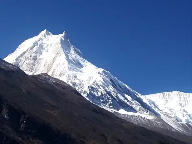
Actually, the thought of trekking around one of the tallest and most stunning mountains in the world is thrilling in itself. This is precisely what the Manaslu Circuit Trek promises to deliver. When calculating the Manaslu Circuit Trek total distance, you'll find it usually averages around 177 km (110 miles). This is far from a typical walk; it's a rigorous trans-Himalayan route that winds its way around Mt. Manaslu, the eighth highest peak in the world at 8,163 meters (26,781 feet).
Likewise, the general scope of the trail takes you from the warm, tropical regions near Machha Khola through dramatic gorges, historic villages and challenging high mountain passes before ultimately descending towards the Annapurna region. Along the way you'll cross the rugged terrain while gaining a unique perspective on the local culture, especially in the prohibited regions. Keep in mind that the average miles per day can be anywhere from 10-18 km, depending on the stage of the hike and altitude.
In fact, the Standard Manaslu Circuit Trek is an epic journey traversing exactly 177 km (110 miles) over 12 to 14 actual days on the trail, beginning at Machha Khola and ending at the juncture of the Dharapani trail.
Manaslu Circuit Trek – a journey through remote villages, deep gorges, high mountain passes, and breathtaking Himalayan scenery.
On a trek like this, the actual number of horizontal kilometers is far less important than the location at which they are covered. A hike of 10km at 4,500 meters would be much more challenging and fatiguing than a 20 km stroll along the riverside just below Jagat.
Most importantly, Haven Holidays focuses on designing itineraries that incorporate this long distance and challenging climb with the necessary rest stops and comfortable lodgings to maintain safety and an enjoyable adventure.
Manaslu Circuit Distance Summary:
Total trekking miles: 177 km (110 miles)
Average miles per day: 12-15 km
Itinerary: Full circuit loop
Terrain: High alpine, high desert to tropical jungle
In summary,the Manaslu Circuit Trek total distance is 177km. It stands as one of the most incredible adventures possible in Nepal. Its remote and pure nature provides a once-in-a-lifetime experience. Contact Haven Holidays to begin the trek of your dreams.
How Long Will it Take? Understanding the Manaslu Circuit Trek Duration
Actually, the factor you will need to consider when planning is the total Manaslu Circuit Trek duration. While the time spent actually hiking is typically 12-14 walking days, the entire expedition usually takes about 15 days when including overland travel to and from Kathmandu as well as required buffer days for permits.
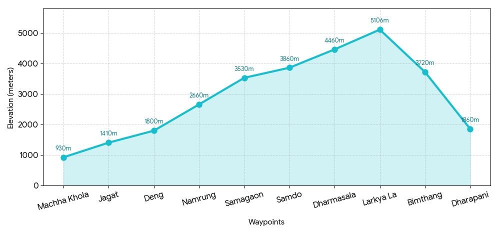
Likewise, standard 14-day trek itineraries should be adequate for reaching the 5,106 meter (16,929 foot) high Larkya Pass safely by including sufficient time to adapt to the elevation gain, unfamiliar surroundings and weather before making the treacherous ascent over the pass. Your mileage needs to coordinate with the time allotted in order to be able to appreciate the villages and the surrounding landscapes that you are passing.
Here, Haven Holidays believes that balance is key. We design a trekking experience that combines the endurance required for the distance with the recuperative time necessary to finish the trip strong.
Manaslu Trek Duration Summary:
Days on the trail: 12-14 days
Entire journey duration: 15 days (including transit)
Itinerary: Standard trip duration (14-16 days)
Days on rest/acclimatization: Included in the trek schedule
What Your Time On The Trail Means for You:
Ample time for altitude acclimatization
The opportunity to immerse yourself in local cultures and visit villages
Reduces the risk of suffering from altitude sickness
A leisurely pace to absorb all of the unique scenery
In fact, "The Standard Manaslu Circuit Trek is an epic journey traversing exactly 177 km (110 miles) over 12 to 14 actual days on the trail, beginning at Machha Khola and ending at the juncture of the Dharapani trail." Haven Holidays Team.
To conclude, a 15 day trip is generally considered the total duration factor when partaking in the 177 km adventure known as the Manaslu Circuit Trek. Please contact Haven Holidays for more information and assistance with your future trek.
Setting the Odometer: The Kathmandu to Machha Khola Drive Distance
Actually, your Manaslu Circuit Trek journey begins with an important overland trip that clicks the odometer before any real hiking starts. This 160 km (99 miles) drive from Kathmandu to Machha Khola is the main point of entry to this remote restricted region and will take you between 7 and 9 hours on a very rugged mountain road. It goes from the paved highways near the capital to narrow roads perched precariously on the side of the cliff-face of the Budhi Gandaki River.
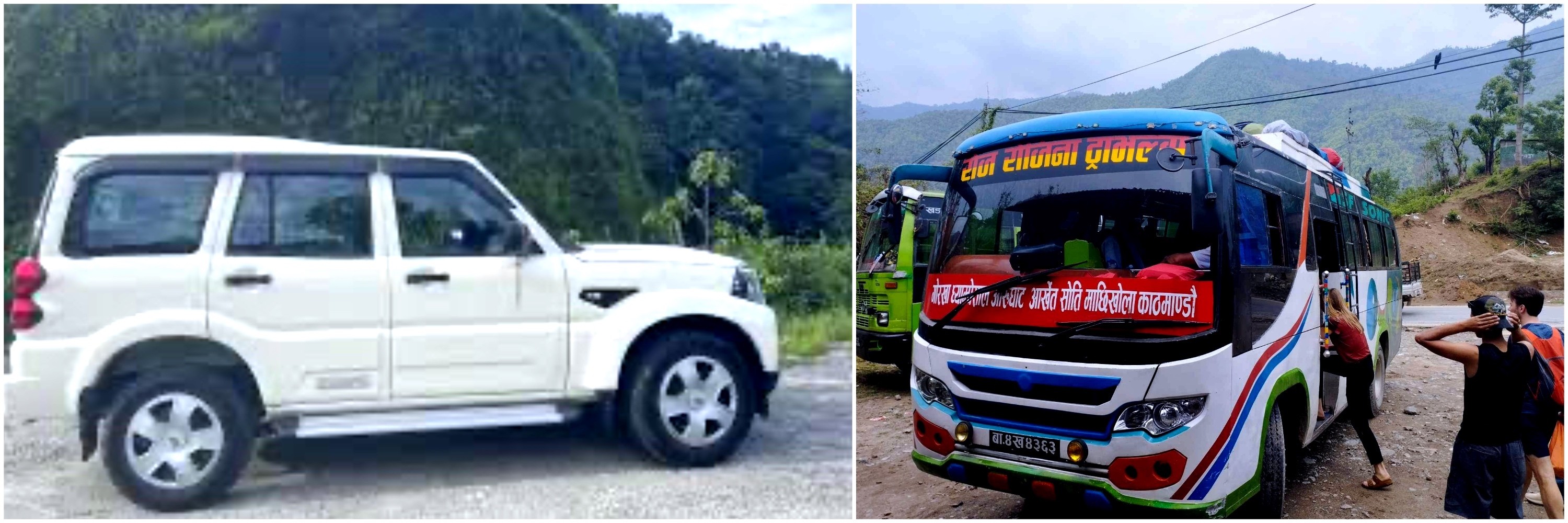
Manaslu Circuit transportation – choose a jeep for comfort and speed or a local bus for a more adventurous journey.
Likewise, this road meanders through pretty terraced fields, villages, and spectacular gorges, as you slowly leave the city behind. It will give you a amazing taste of the Himalaya mountains you are going to explore on foot. The journey also gives you an excellent chance to get to know your guide and check your permits and to mentally prepare yourself for the 177 km circuit ahead.
Here, Haven Holidays provide a private, safe jeep and experienced driver to make your long transfer as easy as possible.
Kathmandu to Machha Khola Drive Summary :
Distance: 160 km (99 miles)
Journey time: 7-9 hours via a private/shared jeep
Road conditions: Prithvi Highway then rugged mountain track
Scenery: River and terraced hills
End point: Machha Khola (870 m / 2,854 ft), the trail head
Day
Distance
Duration | Road Conditions
Kathmandu-Arughat
100 km
4-5 hours | Paved highway
Arughat-Machha Khola
60 km
3-4 hours | Rough off-road mountain track
Total Transfer
160 km (99 miles)
7-9 hours | Roads become progressively rugged
Road Transit Summary :
In conclusion, the Kathmandu to Machha Khola drive is the final essential component that clicks the odometer on the start of the Manaslu Circuit Trek. The drive is organized and gets you to your trail head energized and ready. Contact Haven Holidays today for all your transport needs and fully guided Manaslu Circuit Trek adventure.
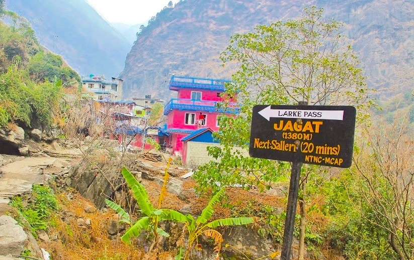
Tracking the Early Miles: The Lower Gorges to Jagat
Here, you officially begin your Manaslu trekking as you track the first few miles from Machha Khola along the Budhi Gandaki river on foot, 22 km (13.7 miles) through steep river gorges and traditional villages. The air at this altitude is still dense and rich with oxygen but your legs may already start to ache at the ups and downs that constantly appear on the path along the riverbed, this segment is expected to take 7-8 hours.
Jagat – the official gateway village to the Manaslu Circuit Trek.
Likewise, you will need to cross numerous suspension bridges, pass through subtropical vegetation and climb stone steps as you make your way through valleys along the powerful Budhi Gandaki River. The trail is lined with villages of the Gurung and Magar people and you will be received with great hospitality. The rhythm of the classic Manaslu trail is introduced here with many stone steps which will help you gain confidence in your footing.
Machha Khola-Jagat Distance Summary :
Initial segment: 22 km (13.7 miles)
Trekking time: 7-8 hours
Scenery: Budhi Gandaki river and gorges
Terrain: Significant uphill including stone steps
First night: Jagat (1,340 m / 4,396 ft)
Section
Distance
Elevation Range | Walking Time
Machha Khola-Jagat
22 km (13.7 miles)
870 m-1,340 m (2,854-4,396 ft) | 7-8 hours
The Early Miles Profile :
In fact, "The total Manaslu Circuit Trek is a 177 kilometer (110 mile) circuit that takes approximately 12-14 days of active trekking starting at Machha Khola and finishing at the junction to the Annapurna trail at Dharapani." Haven Holidays Team
Moreover, the early miles from Machha Khola to Jagat is a challenging first day that creates a solid foundation for your entire Manaslu Circuit Trek adventure. This challenging first day builds up confidence and helps you experience the essence of the trek. Contact Haven Holidays today for an excellent start to your Manaslu Circuit Trek.
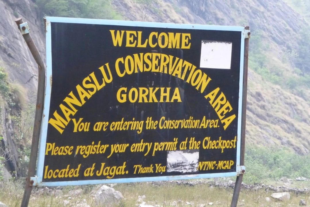
Crossing into the Protected Zone: From Jagat to Deng & Namrung
Beyond the stone gates of Jagat, you enter a completely different political and geographic realm. This is the formal entrance into the Manaslu restricted area, a region that does not allow solo trekkers and where park rangers rigorously document all special permits. Suddenly, the landscape dramatically changes as the Budhi Gandaki river carves itself into a deep, steep canyon.
Entering the Manaslu Conservation Area – gateway to one of Nepal’s most spectacular trekking regions
[Namrung highland center: 2,630 m]- (+540 m climb)
[20 km / 12.4 mi trekking day]
[Deng village: 2,090 m]- (+680 m climb)
[20 km / 12.4 mi trekking day]
[Jagat control gateway: 1,410 m]
Further, moving through this deep canyon requires a ton of physical strength since the Jagat to Deng distance km miles is a 20 km (12.4 mi) challenging trail of continuous up-and-down segments. From Deng, the Deng to Namrung trek miles continues for another 20 km (12.4 mi), and brings you out of the subtropics and into the low pine forests on the edge of the mountain ranges.
Traipsing Through Canyons :
The controlled entrance: In the morning you stop at the official restricted area checkpoint in Jagat where police officers check your group permit, trekking guide license, and passport before granting entry.
The cliff face trail: as the valley narrows to a narrow deep canyon the trail continues directly out of the cliff faces, demanding great caution as you navigate through wet rock paths.
The high swing bridges: the route navigates steep cliff walls using a series of swinging bridges hanging above the fast flowing river.
The sub-alpine transition: once you arrive at Namrung at 2,630 m (8,628 ft), the cornfields have all disappeared and are replaced by rhododendrons and fir trees, indicating you have reached the sub-alpine territory.
Restricted Route Milestone
Altitude Data | Inter-Station Distance
Approximate Walking Time | Dominant Land Form
Jagat Checkpoint Base
1,410m / 4,625ft | 0.0 km / 0.0mi
Start | Alleys and wide river flat terrain within Jagat village.
Deng Gorge Outpost
2,090m / 6,856ft | 20.0 km / 12.4mi
7 - 8 hrs | Narrow, sheer singletracks and hanging iron suspension bridges across the river gorge.
Analysis of Jagat Gateway to Namrung Center Trekking Leg :
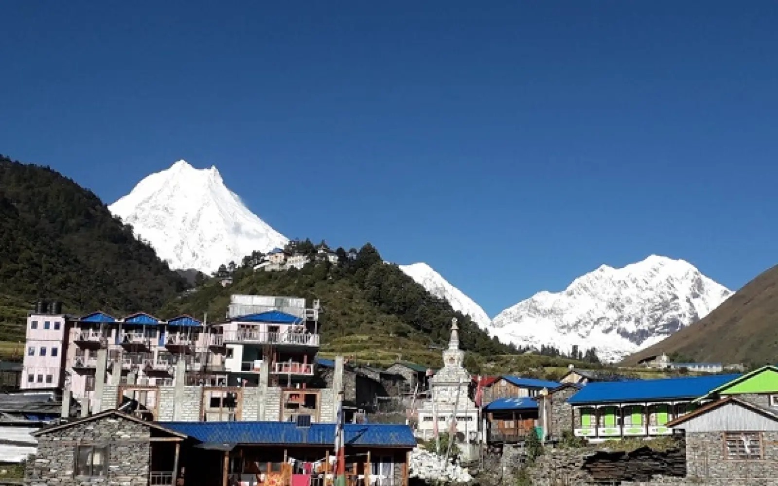
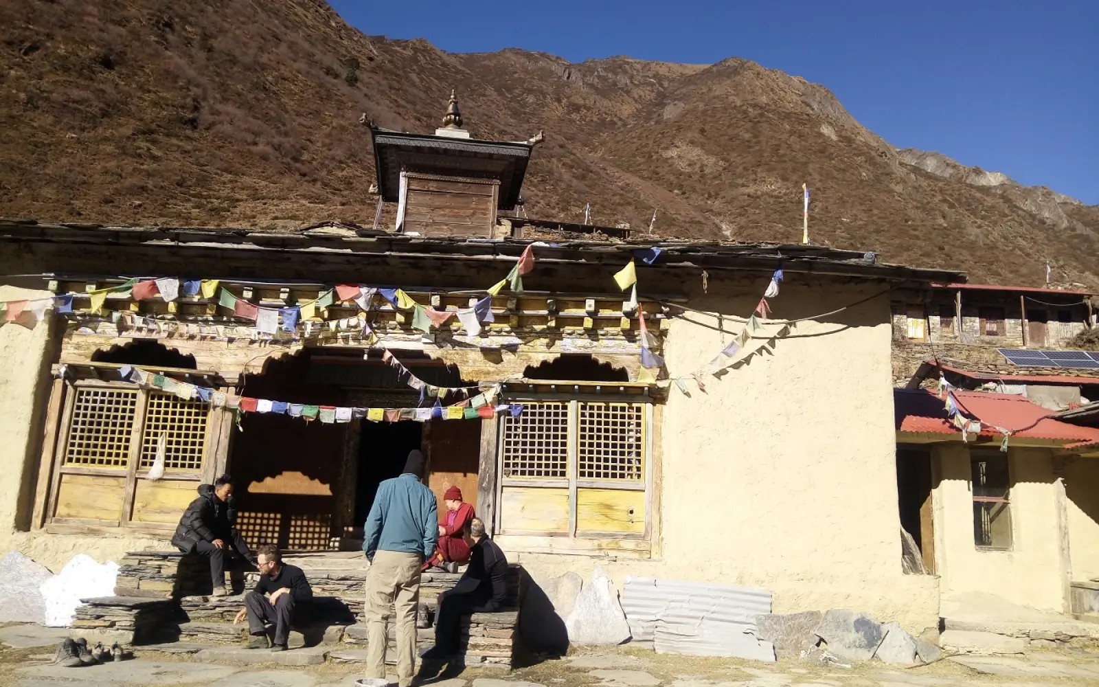
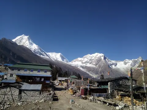
Emerging into the highlands: From Lho to Samagaon
Beyond Namrung the landscapes truly open up, ushering you into the wide, glacial valleys of the Upper Nubri. The deep river canyons left behind give way to vast alpine meadows, walled stone pastures and ancient fields where yaks are pastured under the mountain peaks.
Lho Village – a beautiful Himalayan settlement with stunning views of Mount Manaslu.
[Samagaon valley base: 3,530 m] main acclimatization base- (+350 m climb | 8-9 km / 5-5.6 mi)
[Lho monastery crest: 3,180 m]- (+550 m climb | 10.5 km / 6.5 mi)
[Namrung trail entrance: 2,630 m]
Actually, this stretch leads you to traditional highland Tibetan villages dominated by monasteries, carved Mani walls, and centuries old practices. Although the distance between Namrung to Lho kilometers now decrease to 10.5 km (6.5 mi), the lack of oxygen naturally forces a slower pace. The trek from Lho to Samagaon miles extends over a further 8-9 km (5-5.6 mi) bringing you ever closer to the enormous east wall of Mount Manaslu.
Traversing the Nubri Valley :
The short, slow route: although the day's walking distances become less than 10 km, the thinner air doubles the exertion for any climb. It is crucial to set a steady pace.
The time/distance factor: thin air means slower walking time so that despite a shorter distance you can expect to be walking for 4-5 hours due to your body's need for oxygen.
The monastic vista of Lho: arriving at Lho village at 3,180 m (10,433 ft) rewards you with great views of the two peaks of Manaslu standing behind the golden rooftops of the local Ribung Monastery.
The base for highland acclimatization: the trail opens into a wide glacial plain as you enter Samagaon village at 3,530m (11,581 ft), a historical village that is your base camp for resting and adapting before making your ascent to the highest passes.
Highland Trail Checkpoint
Altitude Metric | Oxygen Density
Peak Trail Surface | Cultural and Environmental Elements
Namrung Outflow
2,630m / 8,628ft | 74% of sea level
Pine needle trails, slick forest mosses | Carved Tibetan Buddhist script gates.
Lho Monastery Ridge
3,180m / 10,433ft | 69% of sea level
Dry, exposed mountain dirt and wide stone steps | Large Mani stones, sweeping Manaslu vistas.
Samagaon Alpine Valley
3,530m / 11,581ft | 66% of sea level
Flat, gravelly glacial valley floor | Traditional dry stone houses, chortens, yak corrals.
Elevation Profile of the ascent into Upper Nubri Highlands :
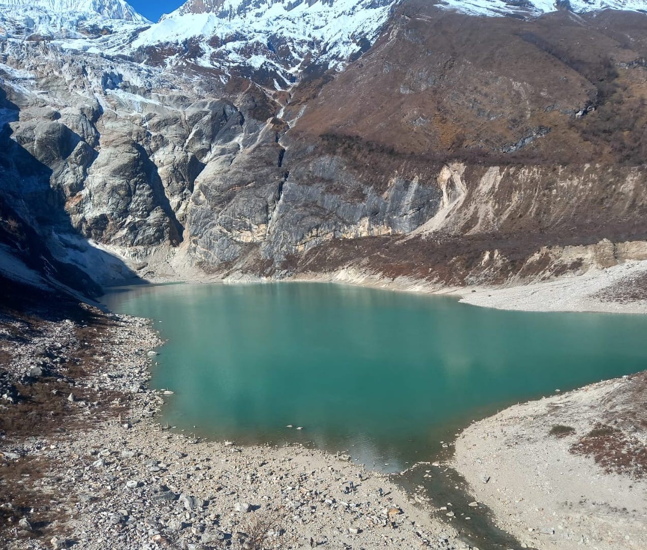
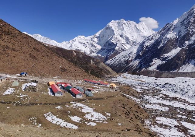
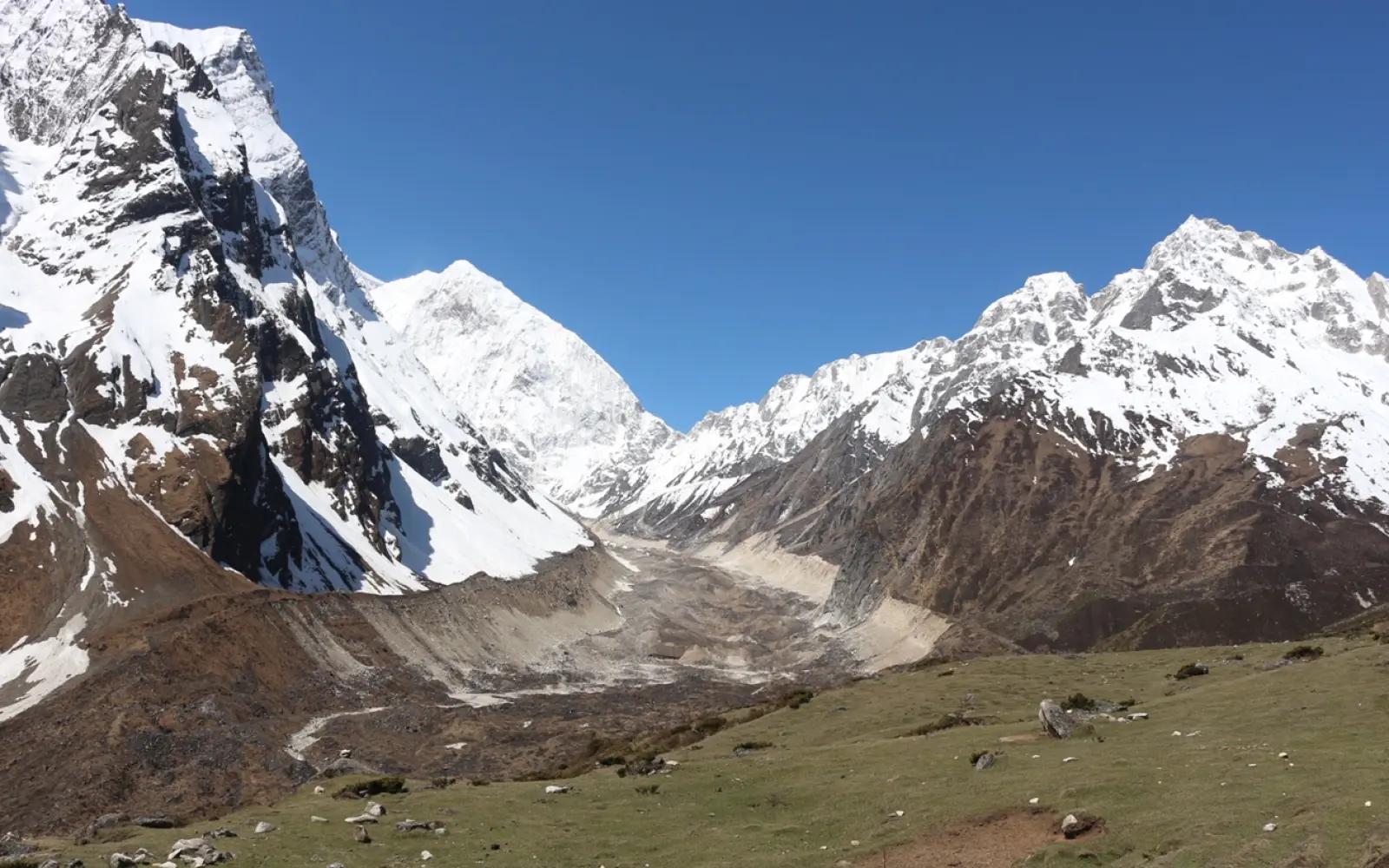
Side Trip Math: Adding distance to Manaslu Base Camp and Birendra Lake
Turn some of your acclimatization days into fantastic extra side trips for rewarding added distance and spectacular views. Adding side-trips from Samagaon makes one of your acclimatization days particularly rewarding while increasing your overall circuit mileage. Take either the 12 km (7.4 mile) round trip hike up to Manaslu Base Camp, or the more gentle 3 km (1.8 mile) sidetrack over to Birendra glacial lake (Birendra Tal).
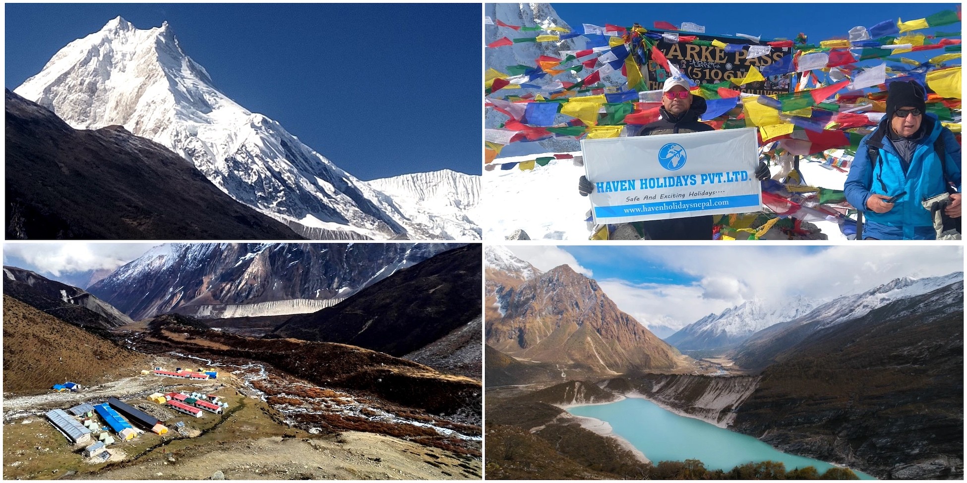
Birendra Lake – a stunning glacial jewel beneath the towering slopes of Manaslu
Here, your hike to Manaslu Base Camp involves trekking over moraine and allows incredible, close-up views of the massive 8,163 m (26,781 ft) peak. In comparison, Birendra Tal is an easy, gentle walk to a striking glacial lake with impossibly turquoise water. Both side-trips make for perfect acclimatisation, and fantastic photo opportunities.
Highlights of the Samagaon side trips :
Distance of Manaslu Base Camp hike: 12 km (7.4 miles) return.
Distance of Birendra Tal walk: 3 km (1.8 miles) return.
Easily added to your overall trek to increase distance.
Side Trip
Distance | Walking time
Elevation gain | Difficulty
Manaslu Base Camp
12 km (7.4 mi) | 5-7 hours
Significant | Moderate-Challenging
Birendra Lake
3 km (1.8 mi) | 1.5-2 hours
Moderate | Easy
Combination of both
15 km total | 7-9 hours
- | Challenging
Side trip distance impact :
Here, it's a recommendation of the Haven Holidays guides to take one of these side-trips for improved acclimatization ahead of your high pass. The choice you make between these options should largely be dependent on your own level of fitness and the weather on the day.
In summary, side-tripping to Manaslu Base Camp and Birendra Lake means there’s plenty of scope to add valuable distance to your trek with minimum added days and maximum rewards. Good treks become spectacular with this addition; contact Haven Holidays today to plan your customized Manaslu Circuit trek with the side trips included.
Staging the Pass: Moving the Footprint from Samagaon to Samdo and Dharmasala
Meanwhile, your body preparation wisely begins at this stage with stages planned carefully on short, gentle sections to move your footprint away from Samagaon up towards the high pass. The short distances between trekking camps in these planned, shallow stages have been specifically designed for acclimatization before tackling Larkya pass. First you trek 8 km (5 miles) to the village of Samdo and then take the further 11.5 km (7.1 miles) to your high altitude camping point at Dharmasala.
Dharmasala – the final stop before crossing the legendary Larke Pass.
Likewise, the stage from Samagaon to Samdo follows fairly flat, level terrain across typical Tibetan-style villages and open valley floors. After Samdo, the trail ascends more steeply to Dharmasala, getting closer to the pass and revealing views towards it. Each of these short day stages will provide your body time to acclimatize safely to the altitude and thinner air.
Highlights of the Samagaon to Dharmasala Stages :
Samagaon to Samdo: 8 km (5 miles)
Samdo to Dharmasala: 11.5 km (7.1 miles)
Establishing a high altitude staging point at Dharmasala
Short distances at higher altitude purposefully designed for acclimatisation
The change in landscape at higher altitude up towards the alpine zone
Section
Distance | Elevation Range
Walking time | Purpose
Samagaon to Samdo
8 km (5 miles) | 3,530 to 3,875 m
3-4 hours | Initial, gentle acclimatisation
Samdo to Dharmasala
11.5 km (7.1mi) | up to 4,460 m (14,633 ft)
5-6 hours | Final elevation gain before pass
Two-day Total
19.5 km | Significant
8-10 hours | Safe progression before the pass.
Distance Profile of The Planned Stages :
In fact, these carefully short stages of trekking up towards the pass are built into all itineraries by Haven Holidays in order to safely prepare you and give your body the best possible chance to acclimatise.
In summary, staging the pass from Samagaon up to Samdo and then Dharmasala are important stages which combine clever trekking planning to maximize acclimatization so you get to experience the challenging pass crossing in a healthy condition. Contact Haven Holidays today to design your Manaslu Circuit trek with excellent, professional acclimatisation.
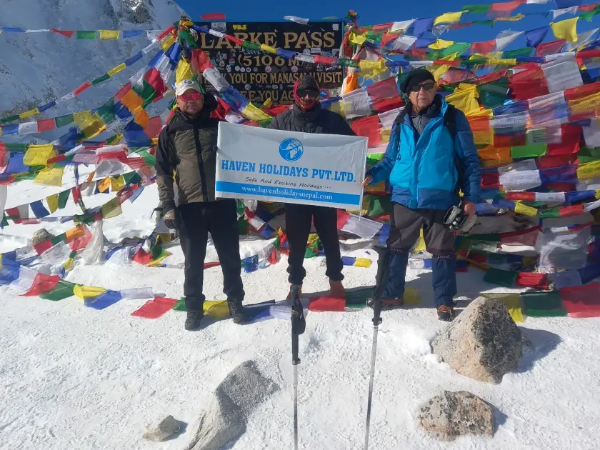
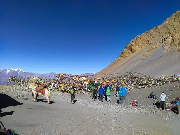
Taming the Longest Day: The Immense Trek over Larkya La Pass to Bhimtang
Meanwhile, this day will undoubtedly be the crucible of your trek-a point where those abstract map lines suddenly transform into a testament to human endurance. The journey from the exposed and frozen accommodations at Dharmasala, over the highest pass, and down into the expansive valley of Bhimtang, demands immense physical and mental effort. Without doubt, this is the toughest stretch of the entire trip and will challenge you in every way possible.
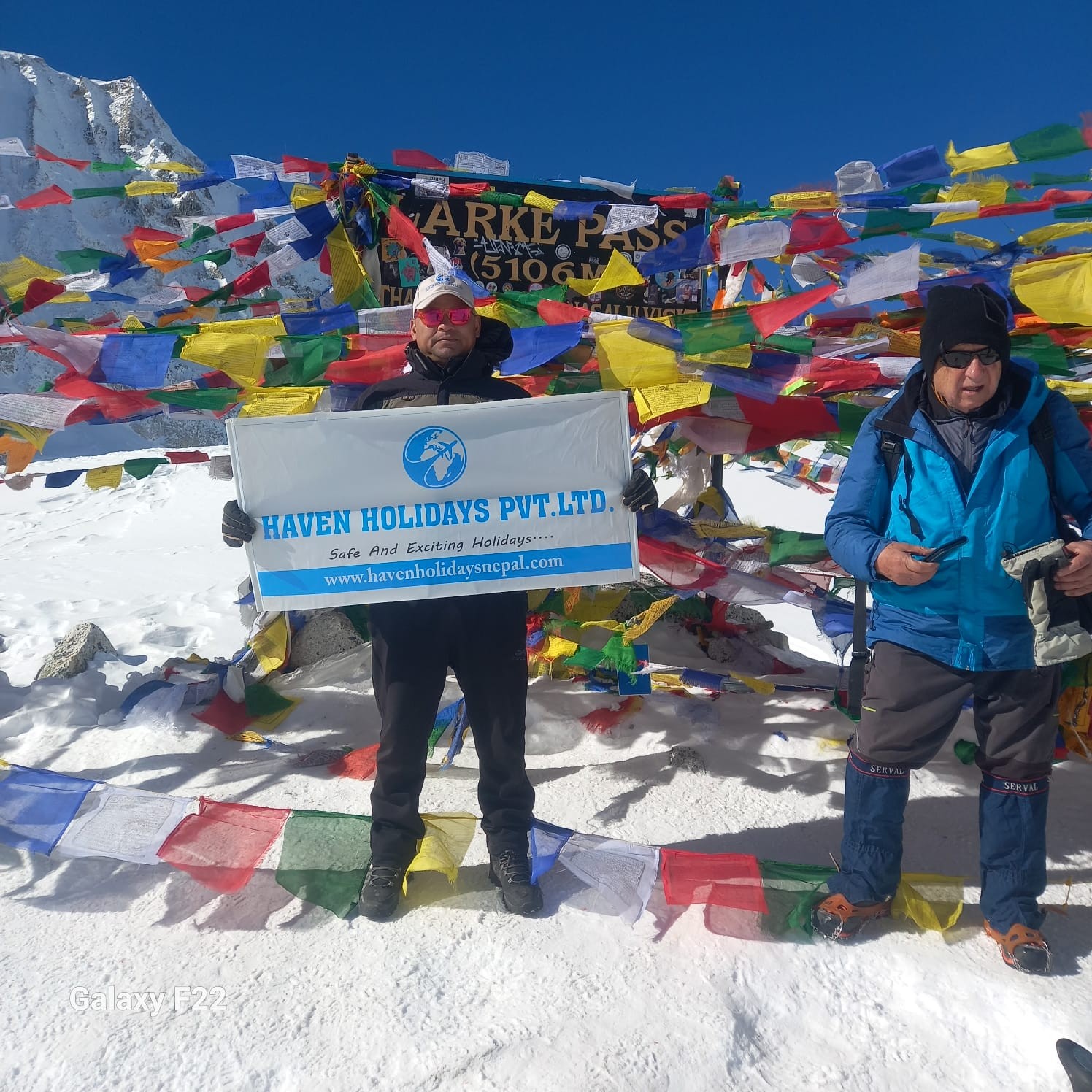
Larke Pass – the breathtaking high point of the Manaslu Circuit Trek.
[Larkya La Pass Summit: 5,160m](Steep, High-Impact Descent) (Slow Pre-Dawn Climb)
[Dharmasala Base Camp: 4,460m] [Bhimtang Alpine Basin: 3,720m]
Total Day Distance: 24.5 km / 15 mi
Actually, this grueling route from Dharmasala to Bhimtang via Larkya La spans 24.5 km (15 mi) through stark and inhospitable terrain. Beginning at 3 AM in complete darkness, this is a 8 to 10 hour endurance feat. The distance km miles you will cross on the Frozen Pass will take you over lateral moraines and snowfields/ice. Indeed, this is by far the longest day on the Manaslu Circuit.
Landmarks of the High Pass :
The Pre-Dawn Push: Leaving the frigid teahouse at Dharmasala by headlamp to climb slowly along side the Larkya Glacier-the cold will make layered technical clothing and insulated water bottles essential.
The Glacial Moraine Grind: The path continues through rocky and steep ridges, and the thin air will force you to take small, steady steps and maintain a controlled heart-rate.
The Prayer Flags at the Summit: You will reach the Larkya La Pass at 5,160m (16,929 ft) covered in a riot of prayer flags and with spectacular views of Himlung Himal, Kang Guru and the giant walls of Annapurna II.
The High-Impact Descent: From the summit, the path immediately drops 1,440 vertical meters down through loose scree and rock to the vibrant green alpine basin of Bhimtang at 3,720m (12,204 ft).
Alpine Route Segment
Elevation Metric | Segment Distance
Est. Walking Time | Trail Terrain & Footing
Dharmasala Camp
4,460 m / 14,632 ft | 0.0 km / 0.0 mi
03:00 AM Start | Frozen dirt paths, loose gravel, and cold stone stairs.
Larkya La Summit
5,160 m / 16,929 ft | 10.2 km / 6.3 mi
4-5 Hours Up | Hard-packed snowfields, slick glacial ice, and loose scree ridges.
Bhimtang Basin
3,720 m / 12,204 ft | 14.3 km / 8.9 mi
4-5 Hours Down | Steep rock switchbacks, loose moraine shale, and alpine grass.
Route Profile: Larkya La Pass Crossing :
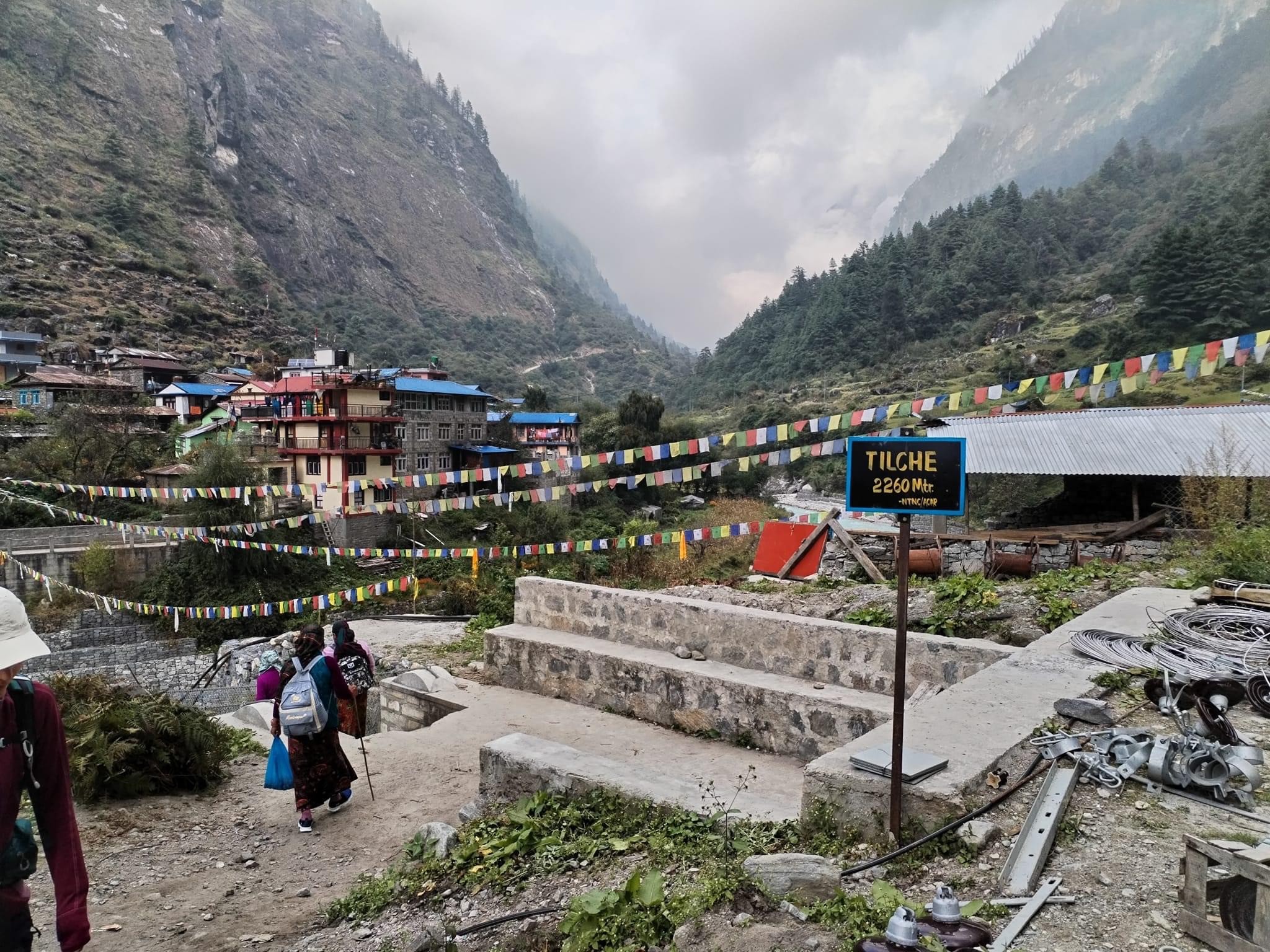
The Retreat Outflow: Through Tilije to the Junction of Dharapani
Having conquered the highest part of the trek, Larkya Pass the descent into the valleys on this day will be a long, pleasant ramble. Leaving the dramatic scenery of Bhimtang, you follow the flow of the Dudh Khola river system all the way to the confluence at the end of the Manaslu Circuit trail.
Tilche Village – a peaceful Himalayan settlement nestled among forests and mountains.
[Bhimtang Base: 3,720 m](19.0 km / 11.8 mi Descent through Pine Forests)
[Tilije Gurung Village: 2,300 m](1.5 km / 0.9 mi Final Gorge Stretch)
[Dharapani Junction: 1,860 m] Connection to Annapurna Circuit Jeep Road
Here, the route from Bhimtang to Tilije distance is 19 km (11.8 mi), through ancient rhododendron woods, dense pine forest and terraced farmland. A final 1.5km (0.9mi) trail, after the village of Tilije, takes you directly to the Annapurna Circuit junction of Dharapani where the loop ends.
Navigating the Final Valley Outflow :
The Forest Trail: Leaving Bhimtang, you descend through dense pine and oak forest, where the increased atmosphere at lower altitude offers welcome ease of breathing.
The Village Approach: The trail descends to the stone-paved lanes of Tilije village at 2,300m (7,545ft) where you will find a welcoming Gurung community and a couple of stone teahouses.
The Junction of Travel: A final suspension bridge over the Marsyangdi River takes you to the town of Dharapani at 1,860m (6,102ft). The Tilije to Dharapani km miles route brings you straight to the jeep-road junction for the Annapurna Circuit, and thus marks the end of your trekking journey around Manaslu and your connection to local transportation to Besisahar and onward to Kathmandu.
Exit Trail Checkpoint
Elevation Metric | Cumulative Distance
Section Duration | Local Landscape Microclimate
Bhimtang High Meadow
3,720 m / 12,204 ft | 0.0 km / 0.0 mi
Departure | Alpine pastures set against ice falls and glacial lakes.
Tilije Stone Village
2,300 m / 7,545 ft | 19.0 km / 11.8 mi
5-6 Hours | Thick pine forests, mossy root trails, and terraced fields.
Dharapani Junction
1,860 m / 6,102 ft | 20.5 km / 12.7 mi
45 Mins | Steep river gorges and busy mountain jeep transport hubs.
Elevation Profile: Bhimtang Valley Outflow to Roadhead :
Customizing Your Odyssey: Variations in Tsum Valley Extension Distance
Take your Manaslu Circuit Trek experience a step further, deeper into remoteness and spirit, with the sacred Tsum Valley extension. This alternative, off-the-beaten-path route provides an oasis of peace within one of the most pristine regions of Nepal. Adding the Tsum Valley extension will add an extra 50 to 60 km (31 to 37 miles) to your journey, along with 4 to 5 more days of trekking, making it a substantial 230+ km wilderness odyssey.
Mu Gompa – the highest and most sacred monastery in the remote Tsum Valley.
Here, starting from Jagat or Philim on the standard route, you will take a turn into the secluded Tsum Valley, an area steeped in ancient Buddhist monasteries, traditional Tibetan-style villages, and stunning alpine meadows. You will traverse deeper into the hidden valley before rejoining the main circuit. The added mileage is significant, but the reward of incredible solitude, deep Buddhist culture, and breathtaking mountain panoramas off the main trail is immense.
Manaslu Circuit with Tsum Valley Extension Highlights :
Extra distance: 50-60 km (31-37 miles)
Additional days: 4-5 trekking days
Total extended mileage: 230+ km
Experience sacred monasteries and pristine landscapes
Ideal for experienced trekkers seeking a true wilderness odyssey
Route Configuration
Total Distance
Duration | Best For
Standard Manaslu Circuit
177 km (110 miles)
14-16 days | Classic remote circuit
With Tsum Valley Extension
230+ km (143+ miles)
18-21 days | Adventurous explorers
Extension Distance Comparison :
Most importantly, Haven Holidays will ensure that the Tsum Valley detour is skillfully integrated into the trek with proper pacing and necessary permits to provide you with an extended and seamless journey.
In conclusion, personalizing your Odyssey with the Tsum Valley extension will transform the standard Manaslu Circuit into an epic once-in-a-lifetime adventure. The additional mileage will translate to deeper cultural understanding and greater serenity. Contact Haven Holidays today to plan your ideal Manaslu Circuit with Tsum Valley extension.
Conclusion: Your Manaslu Circuit Distance Tracking Sheet (Day-by-Day)
To plan your Manaslu Circuit Trek efficiently, use this clean, scannable day-by-day distance tracking sheet. This trail itinerary grid will be your practical pocket guide to the standard 177 km route.
Here, the standard Manaslu Circuit Trek is precisely 177 kilometers (110 miles) and typically completed over 12 to 14 days of active walking, from Machha Khola to the trail intersection at Dharapani.
Day | Route Segment
Distance | Miles
Walking Hours | Key Highlights
1 | Machha Khola to Jagat
22 km | 13.7
7-8 hrs | River gorges & first steps
2 | Jagat to Deng
18-20 km | 11-12.4
6-7 hrs | Budhi Gandaki trail
3 | Deng to Namrung
15-17 km | 9.3-10.5
6-7 hrs | Entering Tibetan culture zone
4 | Namrung to Samagaon
16-18 km | 10-11
6-7 hrs | Approaching Manaslu views
5 | Samagaon (Acclimatization)
8-12 km | 5-7.5
4-6 hrs | Manaslu BC & Birendra Lake (side trips)
6 | Samagaon to Samdo
8 km | 5
3-4 hrs | Short strategic stage
7 | Samdo to Dharmasala
11.5 km | 7.1
5-6 hrs | High altitude staging.
8 | Dharmasala - Larkya La - Bimthang
18-20 km | 11-12.4
8-10 hrs | High pass crossing
9-12| Bimthang to Dharapani
35-40 km | 22-25
5-7 hrs/day | Descent & circuit completion
Total | Full Circuit
177 km | 110 miles
12-14 Days| Complete trans-Himalayan loop
Manaslu Circuit Distance Reference :
Actually, this daily kilometer breakdown checklist will help you monitor your progress and mentally prepare for each stage. The Manaslu Circuit is a perfect blend of challenge, culture, and untouched wilderness.
Manaslu Circuit elevation chart – climb from lush river valleys to the 5,106 m Larke Pass before descending into the Annapurna region.
In conclusion, the Manaslu Circuit Trek with its 177 km distance is an unforgettable Himalayan adventure. Regardless of whether you stick to the classic route or choose to add extensions, careful planning is key to a successful trip. Contact Haven Holidays today to book your fully supported Manaslu Circuit Trek with expert guides, necessary permits, and comfortable teahouses.
One of Nepal's ultimate wilderness journeys, the Manaslu Circuit Trek encircles the world's eighth-highest peak. To prepare sufficiently, trekkers need a good grasp of its mileage and terrain.
Manaslu Circuit Trek Total Distance-FAQs
1. What is the standard Manaslu Circuit Trek total distance? The typical Manaslu Circuit Trek total distance clocks in at approximately 177 kilometers (110 miles) following the classic path. The trek begins down in the Budhi Gandaki valley, a lower Himalayan foothills terrain, and terminates once you merge with the Annapurna Circuit route at Dharapani.
2. How many kilometers do you walk daily on the Manaslu route? During a standard itinerary, your Manaslu Circuit Trek daily walking distance averages 12 to 18 kilometers (7 to 11 miles) per day. While lower altitude segments tend to cover more distance over gentler terrain, higher elevations have significantly shorter walking days for acclimatization.
3. How many days does it take to cover the Manaslu Circuit Trek total distance? A typical trekking itinerary will require 12 to 14 days of active walking to complete the Manaslu Circuit Trek total distance. Accounting for travel to and from the remote trailheads, the full trip lasts about 15 to 16 days total.
4. What is the longest walking day on the Manaslu Circuit itinerary? The most strenuous and lengthiest section on the Manaslu Circuit Trek total distance is the crossing over Larkya Pass, covering approximately 22 to 25 kilometers. This 8 to 10 hour journey will take you from Dharmasala up to a high altitude of 5,106 meters before a steep descent to Bimthang.
5. Does the Manaslu Circuit Trek total distance include vehicle travel? No, the standard 177-kilometer figure is purely for the pedestrian path. It does not factor in the 160-kilometer journey by 4WD vehicle from Kathmandu to the starting point at Machha Khola, nor the return journey from Dharapani back to the capital.
6. How much distance do optional side trips add to the Manaslu trek? Taking a few side excursions along the route can increase the Manaslu Circuit Trek total distance to 190 or 200 kilometers. Popular acclimatization side trips from Samagaun to Manaslu Base Camp, Birendra Lake, or Pungyen Gompa usually involve about 8 to 15 additional kilometers of mountain hiking.
7. Where does the active walking distance officially begin and end? The trekking trail officially begins at Machha Khola (as recent road construction allows) or Soti Khola. It is a continuous trek encircling the entire Manaslu massif, which concludes at Dharapani, where you catch your onward transport back toward civilization.
8. How does the Manaslu Trek distance compare to the Everest Base Camp Trek? The Manaslu Circuit Trek total distance of around 177 kilometers is longer than the standard Everest Base Camp Trek route (round trip of about 130 kilometers). As a continuous loop, it requires longer stints of high-altitude trekking than a typical out-and-back route.
9. Can the Manaslu Circuit Trek total distance be shortened using roads? The expansion of the jeep track in the lower valleys does offer a slight shortcut, pushing your starting point up to Machha Khola and shaving about 14 kilometers off the traditional path. However, the remote core between Jagat and Bimthang remains accessible by foot only.
10. What is the total distance of the combined Manaslu and Tsum Valley Trek? If you opt to incorporate a side trip to the isolated Tsum Valley into your journey, the Manaslu Circuit Trek total distance extends to roughly 230 to 250 kilometers. This extended cultural trek takes a minimum of 18 to 22 days to safely complete.
11. What is the highest point reached along the Manaslu walking route? The highest point of the Manaslu Circuit Trek total distance is the summit of Larkya Pass at 5,106 meters (16,752 feet). This high alpine pass is the toughest challenge on the entire trek.
12. How many hours do you walk per day to complete the circuit? To maintain a good pace on the Manaslu Circuit Trek distance, you can expect to walk 5 to 7 hours daily. As your altitude increases over 3,000 meters, you will slow down to conserve your breathing, so pace yourself accordingly.
13. What is the trail terrain like across the Manaslu distance? The 177-kilometer loop offers a wildly varied trail terrain. Initially, you'll traverse riverbeds, through sub-tropical forests, and over numerous suspension bridges. Higher up, the terrain becomes significantly more challenging with narrow cliffside walkways, glacial moraines, and scree slopes near the pass.
14. Are there rest days built into the Manaslu Circuit distance? A proper Manaslu Circuit Trek itinerary incorporates at least one dedicated acclimatization day, usually at Samagaun (3,530 meters). Although you will not trek along the main circuit route this day, a short hike is recommended to help your body adjust to the altitude.
15. What are the walking distances for the final acclimatization stages? The trekking distances are kept shorter at the high-altitude staging points. The segment from Samagaun to Samdo covers around 8 kilometers (approximately 4 hours). The next segment from Samdo to the high camp at Dharmasala is only 6 to 11 kilometers (approximately 4 hours) and should be taken slowly.
16. How much total elevation gain occurs over the Manaslu distance? Over the Manaslu Circuit Trek distance, you will experience a total elevation gain of over 4,200 vertical meters. This starts at the relatively low elevation of Machha Khola (900 meters) and climbs all the way up to Larkya Pass (5,106 meters).
17. Is the Manaslu Circuit Trek total distance safe for beginner trekkers? The Manaslu Circuit Trek total distance and the high altitude make it quite a challenging trek, even if it doesn't involve technical climbing. Beginners will need to be in good physical condition and have some prior experience with multi-day mountain trekking to attempt it safely.
18. What is the distance from the pass down to the end of the trek? Once you've crossed Larkya La, you'll make a significant descent through alpine meadows and rhododendron forests. From Bimthang, you'll cover 37 kilometers over two days to reach your final destination of Dharapani.
19. Can I complete the Manaslu Circuit Trek distance without a guide? No, the Manaslu region is designated a restricted trekking area by the government, and you are legally required to trek with a licensed guide and a minimum of two other trekkers. This is necessary to be able to clear checkpoints along the route.
20. What is the best season to cover the Manaslu Trek distance? The optimal times to complete the Manaslu Circuit Trek total distance are in autumn (September to November) and spring (March to May). During these months, the weather is generally stable, pass snow is minimal, and the mornings offer clear views of the magnificent Mount Manaslu.

0.81855800 1738673284.webp)